ATL: KIRK - Remnants - Discussion

Moderator: S2k Moderators

Message
Author
tolakram
Admin
Admin
Posts: 20009
Age: 62
Joined: Sun Aug 27, 2006 8:23 pm
Location: Florence, KY (name is Mark)

Re: ATL: KIRK - Remnants - Discussion

#341 Postby tolakram » Wed Sep 26, 2018 5:44 am

brohavwx wrote:
Aric Dunn wrote:Well I suppose I will be the one to point out the obvious. And in no way is this "bashing" or " questioning" or anything of the sorts... only a direct observation.

So lets assume that it is passed the advisory time.

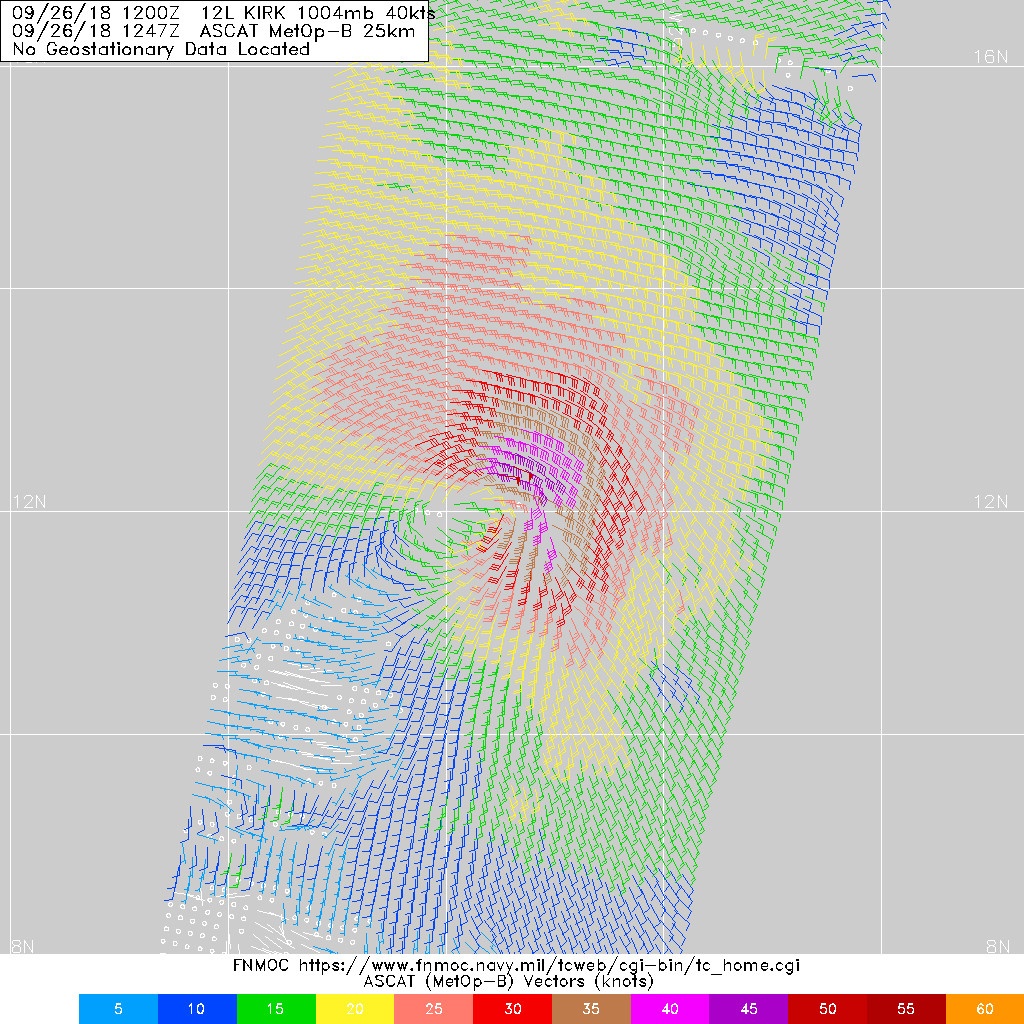
A little timeline... NHC uses ASCAT to upgrade the wave to KIRK. then 24 hours after ASCAT shows an open wave the NHC finally decides to downgrade. then for nearly 2 days relies solely on ASCAT(since the large amount of convection made it difficult to use sat) to determine it is still an open wave... now ASCAT shows a defined closed circ with stronger winds and larger structure than it has ever had but waits to upgrade?

waiting for another ASCAT ? when the first upgrade only took 1 ASCAT to be enough evidence... knowing shear will soon increase and ?? waiting for recon?? leaving the islands with less than 48 hours ( regardless if its a TS or a cat 5).

Well hopefully the 2am outlook will explain something..


As one of my guys just said ... this is "defeating the whole purpose of having the title 'Potential Tropical Cyclone' (PTC)" that the NHC came out with last year or was it the year before. Not to mention we are now under the 48 hours for Barbados at the least.


It's now about 48 hours until the storm crosses the islands. I suspect it would be a PTC if it wasn't upgraded. I'm glad you understand my points about being respectful.
2 likes   
M a r k
- - - - -
Join us in chat: Storm2K Chatroom Invite. Android and IOS apps also available.

The posts in this forum are NOT official forecasts and should not be used as such. Posts are NOT endorsed by any professional institution or STORM2K.org. For official information and forecasts, please refer to NHC and NWS products.

tolakram
Admin
Admin
Posts: 20009
Age: 62
Joined: Sun Aug 27, 2006 8:23 pm
Location: Florence, KY (name is Mark)

Re: ATL: KIRK - Remnants - Discussion

#342 Postby tolakram » Wed Sep 26, 2018 5:48 am

Aric Dunn wrote:up to 90% .... they are just going to wait it out.

despite the evidence.


This is where it crosses the line. Do not tell us what the NHC is going to do, tell us what you observe. I use this as an example of where frustration with the NHC turns into bashing. You do not have all their data and you do not know what their plans are, who they are talking to, or the exact reasons why they are not upgrading. Sorry Aric, but sometimes the backhanded comments by you and others get a little out of hand.
3 likes   
M a r k
- - - - -
Join us in chat: Storm2K Chatroom Invite. Android and IOS apps also available.

The posts in this forum are NOT official forecasts and should not be used as such. Posts are NOT endorsed by any professional institution or STORM2K.org. For official information and forecasts, please refer to NHC and NWS products.

User avatar
Emmett_Brown
Category 5
Category 5
Posts: 1432
Joined: Wed Aug 24, 2005 9:10 pm
Location: Sarasota FL

Re: ATL: KIRK - Tropical Storm - Discussion

#343 Postby Emmett_Brown » Wed Sep 26, 2018 6:23 am

The shear that we were expecting in the immediate vicinity of Kirk is oriented in a way that it is helping to vent him. As the NHC notes in their discussion, the shear is actually going to lessen over the next 24 hours over Kirk, making intensification a possibility before the islands. Inevitably, the shear will weaken the system, but it is fascinating to watch how these interactions play out. Kirk's anticyclone has seemed to push the shear axis just enough to give him some breathing room for the moment.

Also, Kirk's rapid forward motion has slowed to a still brisk 18mph, which reduced relative shear and allowed organization. Some models had hinted at strengthening before the islands. Recon will be interesting for sure!
1 likes   

User avatar
drezee
S2K Supporter
S2K Supporter
Posts: 3664
Joined: Mon Jun 09, 2003 12:49 pm
Location: FL

Re: ATL: KIRK - Tropical Storm - Discussion

#344 Postby drezee » Wed Sep 26, 2018 6:53 am

So, I think recon will be quite surprising this AM...Kirk is making CDO formations that are quite violent.
2 likes   

Aric Dunn
Category 5
Category 5
Posts: 21238
Age: 42
Joined: Sun Sep 19, 2004 9:58 pm
Location: Ready for the Chase.
Contact:

Re: ATL: KIRK - Remnants - Discussion

#345 Postby Aric Dunn » Wed Sep 26, 2018 7:07 am

tolakram wrote:
Aric Dunn wrote:up to 90% .... they are just going to wait it out.

despite the evidence.


This is where it crosses the line. Do not tell us what the NHC is going to do, tell us what you observe. I use this as an example of where frustration with the NHC turns into bashing. You do not have all their data and you do not know what their plans are, who they are talking to, or the exact reasons why they are not upgrading. Sorry Aric, but sometimes the backhanded comments by you and others get a little out of hand.

Well I suppose i should have written a complete sentence. Figured it was implied.

They (at the time) are likely just going to wait it out (like they usually do for recon) despite the current(meaning last night)evidence.

Was no bashing at all and only a direct observation of what they usually do and that is wait for recon if possible.
:D :wink:

Which it appears I was wrong.... they did not wait for recon this time.
3 likes   
Note: If I make a post that is brief. Please refer back to previous posts for the analysis or reasoning. I do not re-write/qoute what my initial post said each time.
If there is nothing before... then just ask :)

Space & Atmospheric Physicist, Embry-Riddle Aeronautical University,
I believe the sky is falling...

brohavwx
Tropical Depression
Tropical Depression
Posts: 74
Age: 63
Joined: Thu Jun 21, 2018 7:16 pm
Location: Barbados
Contact:

Re: ATL: KIRK - Remnants - Discussion

#346 Postby brohavwx » Wed Sep 26, 2018 8:16 am

tolakram wrote:
brohavwx wrote:
Aric Dunn wrote:Well I suppose I will be the one to point out the obvious. And in no way is this "bashing" or " questioning" or anything of the sorts... only a direct observation.

So lets assume that it is passed the advisory time.

A little timeline... NHC uses ASCAT to upgrade the wave to KIRK. then 24 hours after ASCAT shows an open wave the NHC finally decides to downgrade. then for nearly 2 days relies solely on ASCAT(since the large amount of convection made it difficult to use sat) to determine it is still an open wave... now ASCAT shows a defined closed circ with stronger winds and larger structure than it has ever had but waits to upgrade?

waiting for another ASCAT ? when the first upgrade only took 1 ASCAT to be enough evidence... knowing shear will soon increase and ?? waiting for recon?? leaving the islands with less than 48 hours ( regardless if its a TS or a cat 5).

Well hopefully the 2am outlook will explain something..


As one of my guys just said ... this is "defeating the whole purpose of having the title 'Potential Tropical Cyclone' (PTC)" that the NHC came out with last year or was it the year before. Not to mention we are now under the 48 hours for Barbados at the least.


It's now about 48 hours until the storm crosses the islands. I suspect it would be a PTC if it wasn't upgraded. I'm glad you understand my points about being respectful.


Actually, at about 400 miles (now, maybe a bit less) east of Barbados at 18 mph as per NHC estimate we are now well under 20 hours from the starting effects ... but thankfully they have raised us direct to TS Warning ... (I have some of our Govt officials, including people from the other islands, on my own FB forum - and know a few personally - and maybe they heeded my quiet but firm advice from late last night - its not my first rodeo)

Since 5 AM ...

The government of Barbados has issued a Tropical Storm Warning for
Dominica. The government of France has issued a Tropical Storm
Warning for Guadeloupe and Martinique.

SUMMARY OF WATCHES AND WARNINGS IN EFFECT:

A Tropical Storm Warning is in effect for...
* Barbados
* St. Lucia
* Dominica
* Martinique
* Guadeloupe

A Tropical Storm Watch is in effect for...
* St. Vincent and the Grenadines
Last edited by brohavwx on Wed Sep 26, 2018 8:22 am, edited 1 time in total.
1 likes   

Aric Dunn
Category 5
Category 5
Posts: 21238
Age: 42
Joined: Sun Sep 19, 2004 9:58 pm
Location: Ready for the Chase.
Contact:

Re: ATL: KIRK - Tropical Storm - Discussion

#347 Postby Aric Dunn » Wed Sep 26, 2018 8:20 am

Im not sure if the islands do soundings or not. but per recon at about the 400mb level is currently showing very light ssw winds around the islands.

so definitely some credence to the shear dropping for the next 24 hours at least in the mid levels.

Image
Last edited by Aric Dunn on Wed Sep 26, 2018 8:36 am, edited 1 time in total.
0 likes   
Note: If I make a post that is brief. Please refer back to previous posts for the analysis or reasoning. I do not re-write/qoute what my initial post said each time.
If there is nothing before... then just ask :)

Space & Atmospheric Physicist, Embry-Riddle Aeronautical University,
I believe the sky is falling...

LarryWx
S2K Supporter
S2K Supporter
Posts: 6305
Joined: Sun Sep 07, 2003 2:04 pm
Location: GA

Re: ATL: KIRK - Tropical Storm - Discussion

#348 Postby LarryWx » Wed Sep 26, 2018 8:36 am

Aric Dunn wrote:Im not sure if the islands do soundings or not. but per recon at about the 600mb level is showing very light ssw winds.

so definitely some credence to the shear dropping for the next 24 hours at least in the mid levels.

https://image.ibb.co/hJ0WsU/recon_AF305_0112_A_KIRK.png


Would strengthening mean we have to watch for possible further north track like GFS, ICON, Navgem, some CDN ens members, and HWRF have? These all have him 17N to 18N near or just S of PR vs the near 15.5N of the NHC track well south of PR. Or are they all likely out to lunch, regardless?
0 likes   
Personal Forecast Disclaimer:
The posts in this forum are NOT official forecasts and should not be used as such. They are just the opinion of the poster and may or may not be backed by sound meteorological data. They are NOT endorsed by any professional institution or storm2k.org. For official information, please refer to the NHC and NWS products.

Aric Dunn
Category 5
Category 5
Posts: 21238
Age: 42
Joined: Sun Sep 19, 2004 9:58 pm
Location: Ready for the Chase.
Contact:

Re: ATL: KIRK - Tropical Storm - Discussion

#349 Postby Aric Dunn » Wed Sep 26, 2018 8:40 am

LarryWx wrote:
Aric Dunn wrote:Im not sure if the islands do soundings or not. but per recon at about the 400mb level is showing very light ssw winds.

so definitely some credence to the shear dropping for the next 24 hours at least in the mid levels.

https://image.ibb.co/hJ0WsU/recon_AF305_0112_A_KIRK.png


Would strengthening mean we have to watch for possible further north track like GFS, ICON, Navgem, some CDN ens members, and HWRF have? These all have him 17N to 18N near or just S of PR vs the near 15.5N of the NHC track well south of PR. Or are they all likely out to lunch, regardless?


A stronger system would likely take a more wnw track. but at least right now even if it initially takes a more wnw track it will still run into heavy shear that will most likely tear it apart before it reaches PR
1 likes   
Note: If I make a post that is brief. Please refer back to previous posts for the analysis or reasoning. I do not re-write/qoute what my initial post said each time.
If there is nothing before... then just ask :)

Space & Atmospheric Physicist, Embry-Riddle Aeronautical University,
I believe the sky is falling...

Aric Dunn
Category 5
Category 5
Posts: 21238
Age: 42
Joined: Sun Sep 19, 2004 9:58 pm
Location: Ready for the Chase.
Contact:

Re: ATL: KIRK - Tropical Storm - Discussion

#350 Postby Aric Dunn » Wed Sep 26, 2018 8:51 am

REcon will be in the storm soon.. I would wager winds are in the 60mph range.
0 likes   
Note: If I make a post that is brief. Please refer back to previous posts for the analysis or reasoning. I do not re-write/qoute what my initial post said each time.
If there is nothing before... then just ask :)

Space & Atmospheric Physicist, Embry-Riddle Aeronautical University,
I believe the sky is falling...

brohavwx
Tropical Depression
Tropical Depression
Posts: 74
Age: 63
Joined: Thu Jun 21, 2018 7:16 pm
Location: Barbados
Contact:

Re: ATL: KIRK - Tropical Storm - Discussion

#351 Postby brohavwx » Wed Sep 26, 2018 8:52 am

Aric Dunn wrote:Im not sure if the islands do soundings or not. but per recon at about the 600mb level is currently showing very light ssw winds around the islands.


We have a Rawinsonde Station here in Barbados and I am sure the other islands have too, but getting the data from our own local Met Office can be akin to going for a dental degree - if you get my tooth-pulling analogy.

The U.S. Naval Research Laboratory web site used to keep the soundings for us but that link has disappeared and I have been trying to located where it might be found now. The closest I can get is the University of Wyoming site with TFFR in Guadeloupe ... TTPP Piarco in Trinidad may a bit far south but still might be helpful, nothing for us TBPB and the other islands. From last night's soundings - this morning's 8AM are probably still being compiled - show some high winds from the ENE at the 700 mb level and switch to westerly over the 200 mb over Trinidad; about same for Guadeloupe but lower wind speeds.

http://weather.uwyo.edu/cgi-bin/sounding?region=naconf&TYPE=TEXT%3ALIST&YEAR=2018&MONTH=09&FROM=2600&TO=2600&STNM=78897

http://weather.uwyo.edu/cgi-bin/sounding?region=naconf&TYPE=TEXT%3ALIST&YEAR=2018&MONTH=09&FROM=2600&TO=2600&STNM=78970
1 likes   

brohavwx
Tropical Depression
Tropical Depression
Posts: 74
Age: 63
Joined: Thu Jun 21, 2018 7:16 pm
Location: Barbados
Contact:

Re: ATL: KIRK - Tropical Storm - Discussion

#352 Postby brohavwx » Wed Sep 26, 2018 8:53 am

brohavwx wrote:
Aric Dunn wrote:Im not sure if the islands do soundings or not. but per recon at about the 600mb level is currently showing very light ssw winds around the islands.


We have a Rawinsonde Station here in Barbados and I am sure the other islands have too, but getting the data from our own local Met Office can be akin to going for a dental degree - if you get my tooth-pulling analogy.

The U.S. Naval Research Laboratory web site used to keep the soundings for us but that link has disappeared and I have been trying to located where it might be found now. The closest I can get these days is the University of Wyoming site with TFFR in Guadeloupe ... TTPP Piarco in Trinidad may a bit far south but still might be helpful, nothing for us TBPB and the other islands. From last night's soundings - this morning's 8AM are probably still being compiled - show some high winds from the ENE at the 700 mb level and switch to westerly over the 200 mb over Trinidad; about same for Guadeloupe but lower wind speeds.

http://weather.uwyo.edu/cgi-bin/sounding?region=naconf&TYPE=TEXT%3ALIST&YEAR=2018&MONTH=09&FROM=2600&TO=2600&STNM=78897

http://weather.uwyo.edu/cgi-bin/sounding?region=naconf&TYPE=TEXT%3ALIST&YEAR=2018&MONTH=09&FROM=2600&TO=2600&STNM=78970
0 likes   

Aric Dunn
Category 5
Category 5
Posts: 21238
Age: 42
Joined: Sun Sep 19, 2004 9:58 pm
Location: Ready for the Chase.
Contact:

Re: ATL: KIRK - Tropical Storm - Discussion

#353 Postby Aric Dunn » Wed Sep 26, 2018 8:59 am

Also to note. though Kirk is definitely trying to wrap the convection around it still appears as though that has not occurred.

latest microwave. lopsided but the center is surrounded by the convection just very little on the west side.

Image
0 likes   
Note: If I make a post that is brief. Please refer back to previous posts for the analysis or reasoning. I do not re-write/qoute what my initial post said each time.
If there is nothing before... then just ask :)

Space & Atmospheric Physicist, Embry-Riddle Aeronautical University,
I believe the sky is falling...

User avatar
blp
Category 5
Category 5
Posts: 2840
Age: 46
Joined: Thu Sep 09, 2004 7:51 pm
Location: Miami, FL
Contact:

Re: ATL: KIRK - Tropical Storm - Discussion

#354 Postby blp » Wed Sep 26, 2018 9:06 am

Looks like some 50-55 wind barbs on this.

Image
1 likes   
The following post is NOT an official forecast and should not be used as such. It is just the opinion of the poster and may or may not be backed by sound meteorological data. It is NOT endorsed by any professional institution including storm2k.org For Official Information please refer to the NHC and NWS products.

Aric Dunn
Category 5
Category 5
Posts: 21238
Age: 42
Joined: Sun Sep 19, 2004 9:58 pm
Location: Ready for the Chase.
Contact:

Re: ATL: KIRK - Tropical Storm - Discussion

#355 Postby Aric Dunn » Wed Sep 26, 2018 9:07 am

brohavwx wrote:
Aric Dunn wrote:Im not sure if the islands do soundings or not. but per recon at about the 600mb level is currently showing very light ssw winds around the islands.


We have a Rawinsonde Station here in Barbados and I am sure the other islands have too, but getting the data from our own local Met Office can be akin to going for a dental degree - if you get my tooth-pulling analogy.

The U.S. Naval Research Laboratory web site used to keep the soundings for us but that link has disappeared and I have been trying to located where it might be found now. The closest I can get is the University of Wyoming site with TFFR in Guadeloupe ... TTPP Piarco in Trinidad may a bit far south but still might be helpful, nothing for us TBPB and the other islands. From last night's soundings - this morning's 8AM are probably still being compiled - show some high winds from the ENE at the 700 mb level and switch to westerly over the 200 mb over Trinidad; about same for Guadeloupe but lower wind speeds.

http://weather.uwyo.edu/cgi-bin/sounding?region=naconf&TYPE=TEXT%3ALIST&YEAR=2018&MONTH=09&FROM=2600&TO=2600&STNM=78897

http://weather.uwyo.edu/cgi-bin/sounding?region=naconf&TYPE=TEXT%3ALIST&YEAR=2018&MONTH=09&FROM=2600&TO=2600&STNM=78970


thanks.,
looks like they dont update all that often most recent is from 00z. 14 hours ago.
0 likes   
Note: If I make a post that is brief. Please refer back to previous posts for the analysis or reasoning. I do not re-write/qoute what my initial post said each time.
If there is nothing before... then just ask :)

Space & Atmospheric Physicist, Embry-Riddle Aeronautical University,
I believe the sky is falling...

Aric Dunn
Category 5
Category 5
Posts: 21238
Age: 42
Joined: Sun Sep 19, 2004 9:58 pm
Location: Ready for the Chase.
Contact:

Re: ATL: KIRK - Tropical Storm - Discussion

#356 Postby Aric Dunn » Wed Sep 26, 2018 9:13 am

per sat the Center looks about 12.1N 53.6W ish.
0 likes   
Note: If I make a post that is brief. Please refer back to previous posts for the analysis or reasoning. I do not re-write/qoute what my initial post said each time.
If there is nothing before... then just ask :)

Space & Atmospheric Physicist, Embry-Riddle Aeronautical University,
I believe the sky is falling...

Aric Dunn
Category 5
Category 5
Posts: 21238
Age: 42
Joined: Sun Sep 19, 2004 9:58 pm
Location: Ready for the Chase.
Contact:

Re: ATL: KIRK - Tropical Storm - Discussion

#357 Postby Aric Dunn » Wed Sep 26, 2018 9:14 am

recon down to operational.. well to the west of the center. already 40kt winds..

maybe 60mph was a little conservative on my part..
0 likes   
Note: If I make a post that is brief. Please refer back to previous posts for the analysis or reasoning. I do not re-write/qoute what my initial post said each time.
If there is nothing before... then just ask :)

Space & Atmospheric Physicist, Embry-Riddle Aeronautical University,
I believe the sky is falling...

User avatar
SoupBone
Category 5
Category 5
Posts: 3111
Joined: Tue Sep 20, 2005 5:24 pm

Re: ATL: KIRK - Tropical Storm - Discussion

#358 Postby SoupBone » Wed Sep 26, 2018 9:16 am

How many times this year have we seen shear helping a system? I recall observing it several times so far. Eventually, Kirk's luck will run out though. Way too much 40-50kts of shear in his way.
1 likes   
Personal Forecast Disclaimer:
The posts in this forum are NOT official forecast and should not be used as such. They are just the opinion of the poster and may or may not be backed by sound meteorological data. They are NOT endorsed by any professional institution or storm2k.org. For official information, please refer to the NHC and NWS products.

Aric Dunn
Category 5
Category 5
Posts: 21238
Age: 42
Joined: Sun Sep 19, 2004 9:58 pm
Location: Ready for the Chase.
Contact:

Re: ATL: KIRK - Tropical Storm - Discussion

#359 Postby Aric Dunn » Wed Sep 26, 2018 9:24 am

pressure extrap 1002mb and still west of the center.

998mb maybe ? 65mph in the ne quad?
0 likes   
Note: If I make a post that is brief. Please refer back to previous posts for the analysis or reasoning. I do not re-write/qoute what my initial post said each time.
If there is nothing before... then just ask :)

Space & Atmospheric Physicist, Embry-Riddle Aeronautical University,
I believe the sky is falling...

Aric Dunn
Category 5
Category 5
Posts: 21238
Age: 42
Joined: Sun Sep 19, 2004 9:58 pm
Location: Ready for the Chase.
Contact:

Re: ATL: KIRK - Tropical Storm - Discussion

#360 Postby Aric Dunn » Wed Sep 26, 2018 9:35 am

Well they missed the center by a little bit. so looks like 1000 to 1001 mb ..

with a large area of 45 kt winds in the SE quad.

NE quad likely to have higher. I still say 60 to 65 mph.
2 likes   
Note: If I make a post that is brief. Please refer back to previous posts for the analysis or reasoning. I do not re-write/qoute what my initial post said each time.
If there is nothing before... then just ask :)

Space & Atmospheric Physicist, Embry-Riddle Aeronautical University,
I believe the sky is falling...


Return to “2018”

Who is online

Users browsing this forum: No registered users and 2 guests