Broad area of disturbed weather in the Western Caribbean Sea (Is INVEST 91L)
Moderator: S2k Moderators
Forum rules

The posts in this forum are NOT official forecasts and should not be used as such. They are just the opinion of the poster and may or may not be backed by sound meteorological data. They are NOT endorsed by any professional institution or STORM2K. For official information, please refer to products from the National Hurricane Center and National Weather Service.
-
toad strangler

- S2K Supporter

- Posts: 4546
- Joined: Sun Jul 28, 2013 3:09 pm
- Location: Earth
- Contact:
Re: Broad area of disturbed weather in the southwestern Caribbean Sea
NAVY!

0 likes
My Weather Station
https://www.wunderground.com/dashboard/pws/KFLPORTS603
https://www.wunderground.com/dashboard/pws/KFLPORTS603
-
toad strangler
- S2K Supporter
- Posts: 4546
- Joined: Sun Jul 28, 2013 3:09 pm
- Location: Earth
- Contact:
Re: Broad area of disturbed weather in the southwestern Caribbean Sea
LarryWx wrote:toad strangler wrote:Euro doesn't even show a low at 850 mb at 216
The Euro’s lack of strengthening makes sense to me as it is handling the high shear correctly unlike the FV3. Anyone disagree?
Tidbits doesn't show Euro shear maps. I assume they are screaming like the GFS?
0 likes
My Weather Station
https://www.wunderground.com/dashboard/pws/KFLPORTS603
https://www.wunderground.com/dashboard/pws/KFLPORTS603
-
AJC3

- Admin

- Posts: 4153
- Age: 62
- Joined: Tue Aug 31, 2004 7:04 pm
- Location: Ballston Spa, New York
- Contact:
Re: Broad area of disturbed weather in the southwestern Caribbean Sea
An important feature that I haven't seen discussed in this thread yet, and one I think will play a key role in the eventual strength and track of this system is the energy that rotates southward around the western side of Leslie. This trough gets left behind, well east of the Bahamas, on Friday as Leslie gets kicked out to the NE. The trough (or weakly closed mid-upper low) then gets trapped beneath the strong eastern CONUS/western Atlantic ridge to its north and retrogrades W-WSW this weekend. This creates a fairly substantial weakness of some sort to the north and northeast of whatever does develop over the western Caribbean, which would likely impact where and how fast the system eventually moves
Additionally, it also could create some unfavorable shear conditions, especially if it's centered to the N-NE of the Caribbean "mess" (per the slower retrogression of the 12Z OP-GFS. The faster retrogression shown by the 12Z OP-ECM places this trough to the N-NW, which would likely be a little less hostile (more of divergent shear).
In any event, it would probably be a good idea to keep tabs on this feature in the models over the upcoming week.
Here are some model comparisions from 120hr through 168hr. Because of the coarse (60M) resolution of these panels, they really don't give you a good feel at all when it comes to the position and especially the strength/orientation of this trough. If these panels were 10M resolution, it would be much, much better...
120hr

144hr

168hr

192hr (NAVGEM only goes out to 180hr)

Additionally, it also could create some unfavorable shear conditions, especially if it's centered to the N-NE of the Caribbean "mess" (per the slower retrogression of the 12Z OP-GFS. The faster retrogression shown by the 12Z OP-ECM places this trough to the N-NW, which would likely be a little less hostile (more of divergent shear).
In any event, it would probably be a good idea to keep tabs on this feature in the models over the upcoming week.
Here are some model comparisions from 120hr through 168hr. Because of the coarse (60M) resolution of these panels, they really don't give you a good feel at all when it comes to the position and especially the strength/orientation of this trough. If these panels were 10M resolution, it would be much, much better...
120hr
144hr
168hr
192hr (NAVGEM only goes out to 180hr)
9 likes

Re: Broad area of disturbed weather in the southwestern Caribbean Sea
From Bob Henson's blog at weather underground this morning:
Time to watch the Caribbean for development
It’s October, a time of year when the western and central Caribbean Sea typically becomes the Atlantic’s most dangerous breeding ground for hurricanes. So far in 2018, the Caribbean has seen high wind shear and limited hurricane activity due to the presence of a strong subtropical jet stream. However, this may change early next week, when the subtropical jet stream is predicted to lift to the north so that it is positioned over Cuba. This will create a region of lower wind shear over the central and western Caribbean, and recent runs of the GFS and European model have been suggesting that a large area of low pressure will form there this weekend. This low will have the potential to develop into a tropical depression early next week, as predicted by over 30% of the 70 ensemble members of the 0Z Monday GFS and European models. The track such a storm might take is anyone’s guess at this point, and we’ll just have to watch how the models depict the evolution of this potential threat in coming days.
1 likes
-
TheStormExpert
Re: Broad area of disturbed weather in the southwestern Caribbean Sea
SFLcane wrote:TheStormExpert wrote:SFLcane wrote:Very plausible track if you asked me with that massive ridge overhead.
https://www.imageupload.co.uk/images/2018/10/01/yep.gif
Track plausible, strength not so much.
Conditions north of cuba in the bahamas would be favorable so if there is any development down in the carribean look out.
The FV3-GFS has been just as bad, if not worse than the current GFS. Still remember the phantom-cane it had in the Gulf I believe back in late-May or early-June.
0 likes
-
SFLcane

- S2K Supporter
- Posts: 10281
- Age: 48
- Joined: Sat Jun 05, 2010 1:44 pm
- Location: Lake Worth Florida
Re: Broad area of disturbed weather in the southwestern Caribbean Sea
AJC3 wrote:An important feature that I haven't seen discussed in this thread yet, and one I think will play a key role in the eventual strength and track of this system is the energy that rotates southward around the western side of Leslie. This trough gets left behind, well east of the Bahamas, on Friday as Leslie gets kicked out to the NE. The trough (or weakly closed mid-upper low) then gets trapped beneath the strong eastern CONUS/western Atlantic ridge to its north and retrogrades W-WSW this weekend. This creates a fairly substantial weakness of some sort to the north and northeast of whatever does develop over the western Caribbean, which would likely impact where and how fast the system eventually moves
Additionally, it also could create some unfavorable shear conditions, especially if it's centered to the N-NE of the Caribbean "mess" (per the slower retrogression of the 12Z OP-GFS. The faster retrogression shown by the 12Z OP-ECM places this trough to the N-NW, which would likely be a little less hostile (more of divergent shear).
In any event, it would probably be a good idea to keep tabs on this feature in the models over the upcoming week.
Thank you for this AJC3
1 likes
-
floridasun78
- Category 5

- Posts: 3755
- Joined: Sun May 17, 2009 10:16 pm
- Location: miami fl
Re: Broad area of disturbed weather in the southwestern Caribbean Sea
now we wait see nhc pick it up likely wont until late tue ot wed
0 likes
Re: Broad area of disturbed weather in the southwestern Caribbean Sea
toad strangler wrote:LarryWx wrote:toad strangler wrote:Euro doesn't even show a low at 850 mb at 216
The Euro’s lack of strengthening makes sense to me as it is handling the high shear correctly unlike the FV3. Anyone disagree?
Tidbits doesn't show Euro shear maps. I assume they are screaming like the GFS?
Yes until the low gets to off the E coast, when shear drops a lot. While in FL straits, it is 30-40 dropping to 20-30 knots overhead!
Last edited by LarryWx on Mon Oct 01, 2018 2:30 pm, edited 3 times in total.
0 likes
Personal Forecast Disclaimer:
The posts in this forum are NOT official forecasts and should not be used as such. They are just the opinion of the poster and may or may not be backed by sound meteorological data. They are NOT endorsed by any professional institution or storm2k.org. For official information, please refer to the NHC and NWS products.
The posts in this forum are NOT official forecasts and should not be used as such. They are just the opinion of the poster and may or may not be backed by sound meteorological data. They are NOT endorsed by any professional institution or storm2k.org. For official information, please refer to the NHC and NWS products.
-
'CaneFreak

- Category 5
- Posts: 1487
- Joined: Mon Jun 05, 2006 10:50 am
- Location: New Bern, NC
Re: Broad area of disturbed weather in the southwestern Caribbean Sea
Low level vorticity was increasing earlier this morning and now has diminished and split apart again. Going to be a lot of sitting and waiting for the next several days.

Last edited by 'CaneFreak on Mon Oct 01, 2018 2:34 pm, edited 1 time in total.
0 likes
Re: Broad area of disturbed weather in the southwestern Caribbean Sea
NCEP 12z ensemble probabilties of tropical cyclone formation are near 100% in the SW caribbean sea over the next 120 hours.
http://www.emc.ncep.noaa.gov/gmb/tpm/emchurr/tcgen/
http://www.emc.ncep.noaa.gov/gmb/tpm/emchurr/tcgen/
0 likes
Re: Broad area of disturbed weather in the southwestern Caribbean Sea
TheStormExpert wrote:SFLcane wrote:TheStormExpert wrote:Track plausible, strength not so much.
Conditions north of cuba in the bahamas would be favorable so if there is any development down in the carribean look out.
The FV3-GFS has been just as bad, if not worse than the current GFS. Still remember the phantom-cane it had in the Gulf I believe back in late-May or early-June.
Actually the FV3-GFS performed the best of the models during Florence - on par or even better than the ECM. I wouldn't discount it as its a vast improvement over the current GFS.
1 likes
Re: Broad area of disturbed weather in the southwestern Caribbean Sea
ronjon wrote:TheStormExpert wrote:SFLcane wrote:
Conditions north of cuba in the bahamas would be favorable so if there is any development down in the carribean look out.
The FV3-GFS has been just as bad, if not worse than the current GFS. Still remember the phantom-cane it had in the Gulf I believe back in late-May or early-June.
Actually the FV3-GFS performed the best of the models during Florence - on par or even better than the ECM. I wouldn't discount it as its a vast improvement over the current GFS.
Strengthwise too? Did it weaken her to a cat 1 before landfall?
0 likes
Personal Forecast Disclaimer:
The posts in this forum are NOT official forecasts and should not be used as such. They are just the opinion of the poster and may or may not be backed by sound meteorological data. They are NOT endorsed by any professional institution or storm2k.org. For official information, please refer to the NHC and NWS products.
The posts in this forum are NOT official forecasts and should not be used as such. They are just the opinion of the poster and may or may not be backed by sound meteorological data. They are NOT endorsed by any professional institution or storm2k.org. For official information, please refer to the NHC and NWS products.
-
gatorcane

- S2K Supporter
- Posts: 23708
- Age: 48
- Joined: Sun Mar 13, 2005 3:54 pm
- Location: Boca Raton, FL
Re: Broad area of disturbed weather in the southwestern Caribbean Sea
TheStormExpert wrote:SFLcane wrote:TheStormExpert wrote:Track plausible, strength not so much.
Conditions north of cuba in the bahamas would be favorable so if there is any development down in the carribean look out.
The FV3-GFS has been just as bad, if not worse than the current GFS. Still remember the phantom-cane it had in the Gulf I believe back in late-May or early-June.
I would think they have been tweaking the model periodically so it is probably better now than several months ago.
0 likes
Re: Broad area of disturbed weather in the southwestern Caribbean Sea
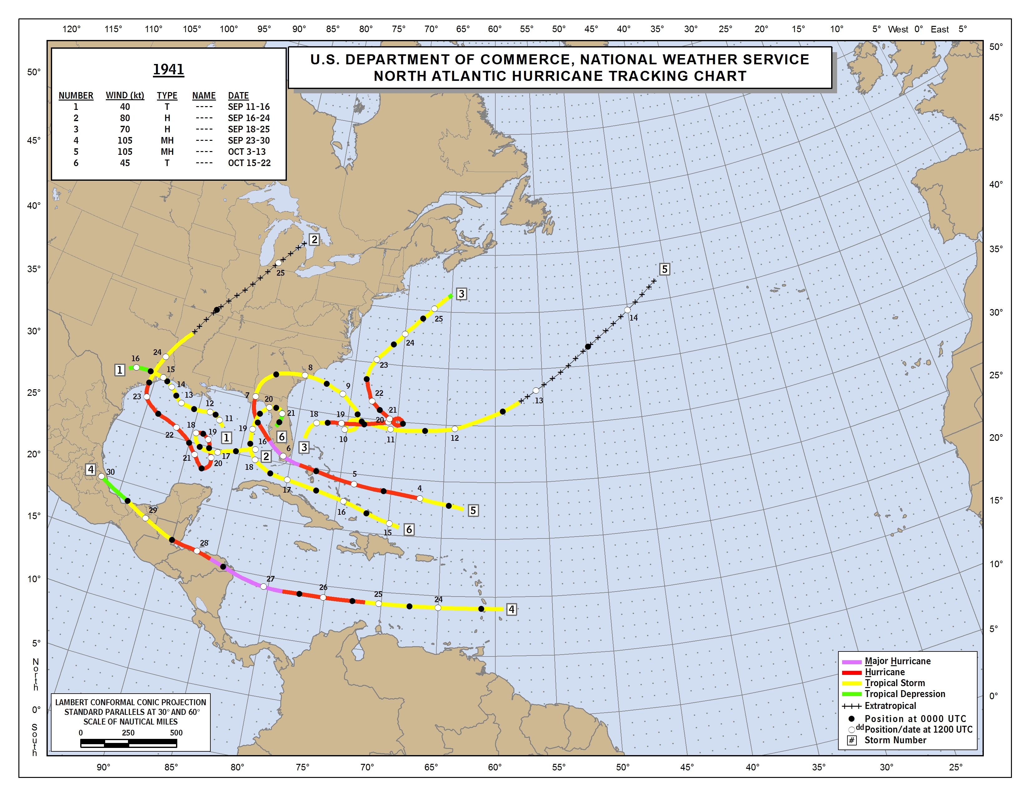
We're lucky to have El Nino upping shear overall. That should lower the chance for anything too strong if it were to come off the ATL into FL/SE vs how it would have been w/o Nino. However, climo is a tool and isn't about absolutes. There are always exceptions, including where a TC finds a slot of low shear. Case in point: the early Oct major H that slammed S FL from the E 10/6/1941 during El Nino:
https://www.nhc.noaa.gov/data/tracks/tracks-at-1941.png
https://www.nhc.noaa.gov/data/tracks/tracks-at-1941.png
1 likes
Personal Forecast Disclaimer:
The posts in this forum are NOT official forecasts and should not be used as such. They are just the opinion of the poster and may or may not be backed by sound meteorological data. They are NOT endorsed by any professional institution or storm2k.org. For official information, please refer to the NHC and NWS products.
The posts in this forum are NOT official forecasts and should not be used as such. They are just the opinion of the poster and may or may not be backed by sound meteorological data. They are NOT endorsed by any professional institution or storm2k.org. For official information, please refer to the NHC and NWS products.
-
SFLcane
- S2K Supporter
- Posts: 10281
- Age: 48
- Joined: Sat Jun 05, 2010 1:44 pm
- Location: Lake Worth Florida
Re: Broad area of disturbed weather in the southwestern Caribbean Sea
12z EPS has about 5 hurricanes surrounding FL so still rather active.
0 likes
-
toad strangler
- S2K Supporter
- Posts: 4546
- Joined: Sun Jul 28, 2013 3:09 pm
- Location: Earth
- Contact:
Re: Broad area of disturbed weather in the southwestern Caribbean Sea
SFLcane wrote:12z EPS has about 5 hurricanes surrounding FL so still rather active.
All at once?
0 likes
My Weather Station
https://www.wunderground.com/dashboard/pws/KFLPORTS603
https://www.wunderground.com/dashboard/pws/KFLPORTS603
Re: Broad area of disturbed weather in the southwestern Caribbean Sea
toad strangler wrote:SFLcane wrote:12z EPS has about 5 hurricanes surrounding FL so still rather active.
All at once?
Besides 2 E coast scrapers, I counted 5 H hits on FL, all Big Bend to Sarasota. 3 on 10/11 and 2 on 10/16.
1 likes
Personal Forecast Disclaimer:
The posts in this forum are NOT official forecasts and should not be used as such. They are just the opinion of the poster and may or may not be backed by sound meteorological data. They are NOT endorsed by any professional institution or storm2k.org. For official information, please refer to the NHC and NWS products.
The posts in this forum are NOT official forecasts and should not be used as such. They are just the opinion of the poster and may or may not be backed by sound meteorological data. They are NOT endorsed by any professional institution or storm2k.org. For official information, please refer to the NHC and NWS products.

Re: Broad area of disturbed weather in the southwestern Caribbean Sea
LarryWx wrote:toad strangler wrote:SFLcane wrote:12z EPS has about 5 hurricanes surrounding FL so still rather active.
All at once?
Besides 2 E coast scrapers, I counted 5 H hits on FL, all Big Bend to Sarasota. 3 on 10/11 and 2 on 10/16.
It's like machine gun rapid fire hurricanes!
0 likes
Personal Forecast Disclaimer:
The posts in this forum are NOT official forecast and should not be used as such. They are just the opinion of the poster and may or may not be backed by sound meteorological data. They are NOT endorsed by any professional institution or storm2k.org. For official information, please refer to the NHC and NWS products.
The posts in this forum are NOT official forecast and should not be used as such. They are just the opinion of the poster and may or may not be backed by sound meteorological data. They are NOT endorsed by any professional institution or storm2k.org. For official information, please refer to the NHC and NWS products.
-
stormlover2013
Re: Broad area of disturbed weather in the southwestern Caribbean Sea
Still don't think anything major, looks wet that's about it, CMC, NAVY, ICON are the ones going over board about it and we know what happens when they do lol meaning those models aren't good so can't trust them long term
0 likes
Re: Broad area of disturbed weather in the southwestern Caribbean Sea
Are there any models beside Euro, GFS, UK that we can trust won't overstrengthen in high shear?
0 likes
Personal Forecast Disclaimer:
The posts in this forum are NOT official forecasts and should not be used as such. They are just the opinion of the poster and may or may not be backed by sound meteorological data. They are NOT endorsed by any professional institution or storm2k.org. For official information, please refer to the NHC and NWS products.
The posts in this forum are NOT official forecasts and should not be used as such. They are just the opinion of the poster and may or may not be backed by sound meteorological data. They are NOT endorsed by any professional institution or storm2k.org. For official information, please refer to the NHC and NWS products.
Who is online
Users browsing this forum: hcane27 and 263 guests