Broad area of disturbed weather in the Western Caribbean Sea (Is INVEST 91L)

This is the general tropical discussion area. Anyone can take their shot at predicting a storms path.

Moderator: S2k Moderators

Forum rules

The posts in this forum are NOT official forecasts and should not be used as such. They are just the opinion of the poster and may or may not be backed by sound meteorological data. They are NOT endorsed by any professional institution or STORM2K. For official information, please refer to products from the National Hurricane Center and National Weather Service.

Help Support Storm2K
Message
Author
Aric Dunn
Category 5
Category 5
Posts: 21238
Age: 42
Joined: Sun Sep 19, 2004 9:58 pm
Location: Ready for the Chase.
Contact:

Re: Broad area of disturbed weather in the southwestern Caribbean Sea

#161 Postby Aric Dunn » Mon Oct 01, 2018 3:26 pm

LarryWx wrote:Are there any models beside Euro, GFS, UK that we can trust won't overstrengthen in high shear?


The models that are intensifying it dont have high shear. the upper environment just plays out differently.

Like I have mentioned already pay attention to the current upper low heading to the Yucutan.

there is variance between how that current upper low plays out and a second upper low that develops and retrogrades ( AJC3 also mentioned this previously) west later in the week. the second one cant come in if the first one does not move or die.

so right now looking at the models past 48 hours is pointless to make any rational decision.

if this current upper low shifts farther west and wnw that will make a conducive environment to see something develop faster ( in the next couple days) if it parks itself about where it is like the GFS and euro say then continued shear as it meanders north and slow development possible.

so we just have to wait and look for some short term trends that might lead to some long term better solutions. i.e if we see something consolidate quicker and not broad.
3 likes   
Note: If I make a post that is brief. Please refer back to previous posts for the analysis or reasoning. I do not re-write/qoute what my initial post said each time.
If there is nothing before... then just ask :)

Space & Atmospheric Physicist, Embry-Riddle Aeronautical University,
I believe the sky is falling...

LarryWx
S2K Supporter
S2K Supporter
Posts: 6301
Joined: Sun Sep 07, 2003 2:04 pm
Location: GA

Re: Broad area of disturbed weather in the southwestern Caribbean Sea

#162 Postby LarryWx » Mon Oct 01, 2018 3:38 pm

SSTs: https://www.nhc.noaa.gov/tafb/sst_loop/14_atl.png

The worry is that IF this gets into fav shear, these SSTs of 29-30C off SE/Gulf, which are as warm as the W Car and are normal for Aug, will provide extra fuel. Look at the Big Bend: over 30C, hottest in entire basin! This is not normal.
0 likes   
Personal Forecast Disclaimer:
The posts in this forum are NOT official forecasts and should not be used as such. They are just the opinion of the poster and may or may not be backed by sound meteorological data. They are NOT endorsed by any professional institution or storm2k.org. For official information, please refer to the NHC and NWS products.

User avatar
SFLcane
S2K Supporter
S2K Supporter
Posts: 10163
Age: 47
Joined: Sat Jun 05, 2010 1:44 pm
Location: Lake Worth Florida

Re: Broad area of disturbed weather in the southwestern Caribbean Sea

#163 Postby SFLcane » Mon Oct 01, 2018 3:47 pm

You can already see convection increasing down there...

Image
0 likes   

TheStormExpert

Re: Broad area of disturbed weather in the southwestern Caribbean Sea

#164 Postby TheStormExpert » Mon Oct 01, 2018 3:53 pm

LarryWx wrote:
toad strangler wrote:
SFLcane wrote:12z EPS has about 5 hurricanes surrounding FL so still rather active.


All at once?

:lol:


Besides 2 E coast scrapers, I counted 5 H hits on FL, all Big Bend to Sarasota. 3 on 10/11 and 2 on 10/16.

Hopefully those two are wrong as that’s my birthday. :lol:
0 likes   

User avatar
AtlanticWind
S2K Supporter
S2K Supporter
Posts: 1887
Age: 66
Joined: Sun Aug 08, 2004 9:57 pm
Location: Plantation,Fla

Re: Broad area of disturbed weather in the southwestern Caribbean Sea

#165 Postby AtlanticWind » Mon Oct 01, 2018 3:55 pm

LarryWx wrote:Are there any models beside Euro, GFS, UK that we can trust won't overstrengthen in high shear?

You can't trust any models that much over 72 hours when it comes to genesis
0 likes   

Aric Dunn
Category 5
Category 5
Posts: 21238
Age: 42
Joined: Sun Sep 19, 2004 9:58 pm
Location: Ready for the Chase.
Contact:

Re: Broad area of disturbed weather in the southwestern Caribbean Sea

#166 Postby Aric Dunn » Mon Oct 01, 2018 4:01 pm

Currently that upper low the last 8 hours has been moving at a pretty good clip to the w.
in response to that you can the outflow from the convection go from blowing off to the NE now expanding N and NW as an anticyclone builds across the SW carrib.

Image
0 likes   
Note: If I make a post that is brief. Please refer back to previous posts for the analysis or reasoning. I do not re-write/qoute what my initial post said each time.
If there is nothing before... then just ask :)

Space & Atmospheric Physicist, Embry-Riddle Aeronautical University,
I believe the sky is falling...

Abdullah
Category 1
Category 1
Posts: 379
Joined: Sat Sep 08, 2018 4:28 pm
Location: Miramar, FL

Re: Broad area of disturbed weather in the southwestern Caribbean Sea

#167 Postby Abdullah » Mon Oct 01, 2018 4:02 pm

LarryWx wrote:SSTs: https://www.nhc.noaa.gov/tafb/sst_loop/14_atl.png

The worry is that IF this gets into fav shear, these SSTs of 29-30C off SE/Gulf, which are as warm as the W Car and are normal for Aug, will provide extra fuel. Look at the Big Bend: over 30C, hottest in entire basin! This is not normal.


Does anyone know the SST(Sea Surface Temperature)s Wilma intensified on?
Also, why the big difference between the FV3 and GFS? The FV3 is obviously not the new model, which, as someone earlier stated, is projected to come out 2019.

Regular GFS :darrow: Nothing at all. The whole model.
Image
The FV3 :darrow: Brings 972 mB Hurricane into SouthEast Florida
Image
Last edited by Abdullah on Mon Oct 01, 2018 4:24 pm, edited 1 time in total.
0 likes   

User avatar
gatorcane
S2K Supporter
S2K Supporter
Posts: 23691
Age: 47
Joined: Sun Mar 13, 2005 3:54 pm
Location: Boca Raton, FL

Re: Broad area of disturbed weather in the southwestern Caribbean Sea

#168 Postby gatorcane » Mon Oct 01, 2018 4:04 pm

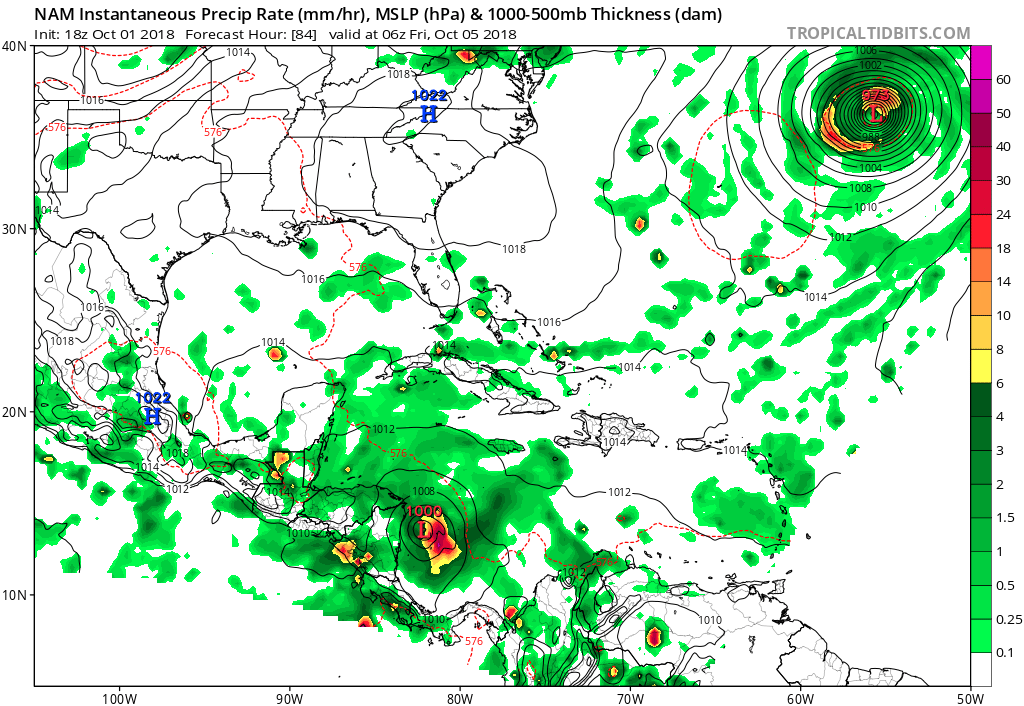
18Z NAM much more bullish:

Image
0 likes   

Aric Dunn
Category 5
Category 5
Posts: 21238
Age: 42
Joined: Sun Sep 19, 2004 9:58 pm
Location: Ready for the Chase.
Contact:

Re: Broad area of disturbed weather in the southwestern Caribbean Sea

#169 Postby Aric Dunn » Mon Oct 01, 2018 4:08 pm

gatorcane wrote:18Z NAM much more bullish:

https://i.postimg.cc/43wQYczk/nam_mslp_pcpn_watl_28.png


yes. compare the sterngth and position of the current up low from 12z to 18z you will see why.
:)
1 likes   
Note: If I make a post that is brief. Please refer back to previous posts for the analysis or reasoning. I do not re-write/qoute what my initial post said each time.
If there is nothing before... then just ask :)

Space & Atmospheric Physicist, Embry-Riddle Aeronautical University,
I believe the sky is falling...

Aric Dunn
Category 5
Category 5
Posts: 21238
Age: 42
Joined: Sun Sep 19, 2004 9:58 pm
Location: Ready for the Chase.
Contact:

Re: Broad area of disturbed weather in the southwestern Caribbean Sea

#170 Postby Aric Dunn » Mon Oct 01, 2018 4:17 pm

Abdullah wrote:
LarryWx wrote:SSTs: https://www.nhc.noaa.gov/tafb/sst_loop/14_atl.png

The worry is that IF this gets into fav shear, these SSTs of 29-30C off SE/Gulf, which are as warm as the W Car and are normal for Aug, will provide extra fuel. Look at the Big Bend: over 30C, hottest in entire basin! This is not normal.


Does anyone know the SST(Sea Surface Temperature)s Wilma intensified on?
Also, why the big difference between the FV3 and GFS? The FV3 is obviously not the new model, which, as someone earlier stated, is projected to come out.

Regular GFS :darrow: Nothing at all. The whole model.
http://i66.tinypic.com/2is9kq8.png
The FV3 :darrow: Brings 972 mB Hurricane into SouthEast Florida
http://i64.tinypic.com/15z2lft.png


what do you mean the FV3 gfs is not new ?

it very much is. it is the GFS built around the Finite Volume core (in this case version 3 I believe it has been in testing for years in various incarnations?). the resolution among many other things are new and improved.

its actually fun way to resolve some issues with various differential equation solutions using some geometry based algebraic methods. nothing new there really but the computations are slightly faster I suppose and you can get better resolution in smaller spatial grids.
0 likes   
Note: If I make a post that is brief. Please refer back to previous posts for the analysis or reasoning. I do not re-write/qoute what my initial post said each time.
If there is nothing before... then just ask :)

Space & Atmospheric Physicist, Embry-Riddle Aeronautical University,
I believe the sky is falling...

Abdullah
Category 1
Category 1
Posts: 379
Joined: Sat Sep 08, 2018 4:28 pm
Location: Miramar, FL

Re: Broad area of disturbed weather in the southwestern Caribbean Sea

#171 Postby Abdullah » Mon Oct 01, 2018 4:30 pm

Aric Dunn wrote:
Abdullah wrote:
LarryWx wrote:SSTs: https://www.nhc.noaa.gov/tafb/sst_loop/14_atl.png

The worry is that IF this gets into fav shear, these SSTs of 29-30C off SE/Gulf, which are as warm as the W Car and are normal for Aug, will provide extra fuel. Look at the Big Bend: over 30C, hottest in entire basin! This is not normal.


Does anyone know the SST(Sea Surface Temperature)s Wilma intensified on?
Also, why the big difference between the FV3 and GFS? The FV3 is obviously not the new model, which, as someone earlier stated, is projected to come out 2019.

Regular GFS :darrow: Nothing at all. The whole model.
http://i66.tinypic.com/2is9kq8.png
The FV3 :darrow: Brings 972 mB Hurricane into SouthEast Florida
http://i64.tinypic.com/15z2lft.png


what do you mean the FV3 gfs is not new ?

it very much is. it is the GFS built around the Finite Volume core (in this case version 3 I believe it has been in testing for years in various incarnations?). the resolution among many other things are new and improved.

its actually fun way to resolve some issues with various differential equation solutions using some geometry based algebraic methods. nothing new there really but the computations are slightly faster I suppose and you can get better resolution in smaller spatial grids.


No, I'm talking about the newer one. the 2019 one. As said earlier in the thread, someone was saying that they missed a bit, and what was the FV3, is it the new one. The next person said it'll come out 2019.

I've scoured this thread 3 times for that and I still can't find it.

EDIT: found it

ronjon wrote:
DESTRUCTION5 wrote:
SFLcane wrote:Very plausible track if you asked me with that massive ridge overhead.

https://www.imageupload.co.uk/images/2018/10/01/yep.gif


I must have missed the memo sometime...is this model considered the new GFS?


Will be starting in 2019.
1 likes   

jlauderdal
S2K Supporter
S2K Supporter
Posts: 7182
Joined: Wed May 19, 2004 5:46 am
Location: NE Fort Lauderdale
Contact:

Re: RE: Re: Broad area of disturbed weather in the southwestern Caribbean Sea

#172 Postby jlauderdal » Mon Oct 01, 2018 4:55 pm

South floridians know the drill with hits this far out
Abdullah wrote:
LarryWx wrote:SSTs: https://www.nhc.noaa.gov/tafb/sst_loop/14_atl.png

The worry is that IF this gets into fav shear, these SSTs of 29-30C off SE/Gulf, which are as warm as the W Car and are normal for Aug, will provide extra fuel. Look at the Big Bend: over 30C, hottest in entire basin! This is not normal.


Does anyone know the SST(Sea Surface Temperature)s Wilma intensified on?
Also, why the big difference between the FV3 and GFS? The FV3 is obviously not the new model, which, as someone earlier stated, is projected to come out 2019.

Regular GFS :darrow: Nothing at all. The whole model.
Image
The FV3 :darrow: Brings 972 mB Hurricane into SouthEast Florida
Image
0 likes   

Aric Dunn
Category 5
Category 5
Posts: 21238
Age: 42
Joined: Sun Sep 19, 2004 9:58 pm
Location: Ready for the Chase.
Contact:

Re: Broad area of disturbed weather in the southwestern Caribbean Sea

#173 Postby Aric Dunn » Mon Oct 01, 2018 5:03 pm

well would you look at that.. the 18z GFS takes that current upper low and moves it wnw into southern gulf. in response, there is a much more coherent vort moving in the NW carrib. looking much more reasonable so far.

does not do too much on intensity mostly because it looks to be partially over land.
0 likes   
Note: If I make a post that is brief. Please refer back to previous posts for the analysis or reasoning. I do not re-write/qoute what my initial post said each time.
If there is nothing before... then just ask :)

Space & Atmospheric Physicist, Embry-Riddle Aeronautical University,
I believe the sky is falling...

Dean4Storms
S2K Supporter
S2K Supporter
Posts: 6358
Age: 62
Joined: Sun Aug 31, 2003 1:01 pm
Location: Miramar Bch. FL

Re: Broad area of disturbed weather in the southwestern Caribbean Sea

#174 Postby Dean4Storms » Mon Oct 01, 2018 5:05 pm

Starting to see more and more model agreement on some form of a Low down there and some of the highest TC Heat Potential resides currently over the Western Carib. Sea in the whole Atlantic Basin. We've seen heavily sheared systems spin up down there when the TCHP is this high so not ruling out a hurricane that is for sure. The fact that the 12z ECM OP does little also does not rule out development, it's been known to be late to the party down there in the past.
0 likes   

User avatar
Nimbus
Category 5
Category 5
Posts: 5300
Joined: Mon Jul 19, 2004 10:54 am

Re: Broad area of disturbed weather in the southwestern Caribbean Sea

#175 Postby Nimbus » Mon Oct 01, 2018 5:05 pm

Butterfly effect is better modeled with newer technology or is there a limit?
I thought there were hard limits to chaos theory that would render newer models just as inaccurate.
0 likes   

AutoPenalti
Category 5
Category 5
Posts: 4030
Age: 29
Joined: Mon Aug 17, 2015 4:16 pm
Location: Ft. Lauderdale, Florida

Re: Broad area of disturbed weather in the southwestern Caribbean Sea

#176 Postby AutoPenalti » Mon Oct 01, 2018 5:22 pm

If model runs were precise on strength and location, this thread wouldn’t be 8 pages long. :cheesy:
3 likes   
The posts in this forum are NOT official forecasts and should not be used as such. They are just the opinion of the poster and may or may not be backed by sound meteorological data. They are NOT endorsed by any professional institution or STORM2K. For official information, please refer to products from the NHC and NWS.


Model Runs Cheat Sheet:
GFS (5:30 AM/PM, 11:30 AM/PM)
HWRF, GFDL, UKMET, NAVGEM (6:30-8:00 AM/PM, 12:30-2:00 AM/PM)
ECMWF (1:45 AM/PM)

TCVN
is a weighted averaged

Aric Dunn
Category 5
Category 5
Posts: 21238
Age: 42
Joined: Sun Sep 19, 2004 9:58 pm
Location: Ready for the Chase.
Contact:

Re: Broad area of disturbed weather in the southwestern Caribbean Sea

#177 Postby Aric Dunn » Mon Oct 01, 2018 5:26 pm

well at least the first 120 hours were reasonable.. now we are back to a string of pearls for the 18z gfs.

but a notable change either way.
0 likes   
Note: If I make a post that is brief. Please refer back to previous posts for the analysis or reasoning. I do not re-write/qoute what my initial post said each time.
If there is nothing before... then just ask :)

Space & Atmospheric Physicist, Embry-Riddle Aeronautical University,
I believe the sky is falling...

User avatar
ronjon
Category 5
Category 5
Posts: 4822
Joined: Fri Aug 19, 2005 5:17 pm
Location: Hernando Beach, FL

Re: Broad area of disturbed weather in the southwestern Caribbean Sea

#178 Postby ronjon » Mon Oct 01, 2018 5:28 pm

Abdullah wrote:
Aric Dunn wrote:
Abdullah wrote:
Does anyone know the SST(Sea Surface Temperature)s Wilma intensified on?
Also, why the big difference between the FV3 and GFS? The FV3 is obviously not the new model, which, as someone earlier stated, is projected to come out 2019.

Regular GFS :darrow: Nothing at all. The whole model.
http://i66.tinypic.com/2is9kq8.png
The FV3 :darrow: Brings 972 mB Hurricane into SouthEast Florida
http://i64.tinypic.com/15z2lft.png


what do you mean the FV3 gfs is not new ?

it very much is. it is the GFS built around the Finite Volume core (in this case version 3 I believe it has been in testing for years in various incarnations?). the resolution among many other things are new and improved.

its actually fun way to resolve some issues with various differential equation solutions using some geometry based algebraic methods. nothing new there really but the computations are slightly faster I suppose and you can get better resolution in smaller spatial grids.


No, I'm talking about the newer one. the 2019 one. As said earlier in the thread, someone was saying that they missed a bit, and what was the FV3, is it the new one. The next person said it'll come out 2019.

I've scoured this thread 3 times for that and I still can't find it.

EDIT: found it

ronjon wrote:
DESTRUCTION5 wrote:
I must have missed the memo sometime...is this model considered the new GFS?


Will be starting in 2019.


The FV3 is scheduled to completely replace the existing GFS in 2019. It's commonly called the parallel GFS now.
0 likes   

Aric Dunn
Category 5
Category 5
Posts: 21238
Age: 42
Joined: Sun Sep 19, 2004 9:58 pm
Location: Ready for the Chase.
Contact:

Re: Broad area of disturbed weather in the southwestern Caribbean Sea

#179 Postby Aric Dunn » Mon Oct 01, 2018 5:32 pm

lol the GFS looks like a petri dish of cells undergoing mitosis .....:P
1 likes   
Note: If I make a post that is brief. Please refer back to previous posts for the analysis or reasoning. I do not re-write/qoute what my initial post said each time.
If there is nothing before... then just ask :)

Space & Atmospheric Physicist, Embry-Riddle Aeronautical University,
I believe the sky is falling...

User avatar
gatorcane
S2K Supporter
S2K Supporter
Posts: 23691
Age: 47
Joined: Sun Mar 13, 2005 3:54 pm
Location: Boca Raton, FL

Re: Broad area of disturbed weather in the southwestern Caribbean Sea

#180 Postby gatorcane » Mon Oct 01, 2018 5:41 pm

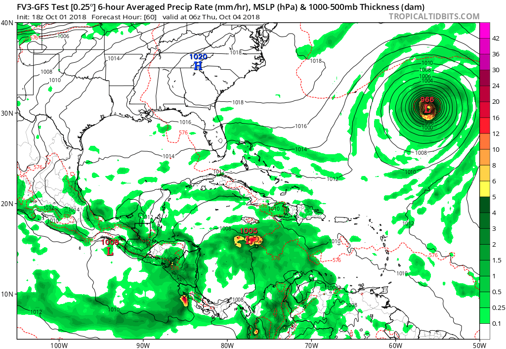
FV3 GFS going with a 1005mb low in just 60 hours:

Image
0 likes   


Return to “Talkin' Tropics”

Who is online

Users browsing this forum: abajan, gib and 22 guests