Broad area of disturbed weather in the Western Caribbean Sea (Is INVEST 91L)
Moderator: S2k Moderators
Forum rules

The posts in this forum are NOT official forecasts and should not be used as such. They are just the opinion of the poster and may or may not be backed by sound meteorological data. They are NOT endorsed by any professional institution or STORM2K. For official information, please refer to products from the National Hurricane Center and National Weather Service.

Re: Broad area of disturbed weather in the southwestern Caribbean Sea
Jamaica buoy reporting 1009.5 mb
0 likes
Re: Broad area of disturbed weather in the southwestern Caribbean Sea
COAMPS spins it up in about 90 hrs.
Heading to the Yucatan Channel.

Heading to the Yucatan Channel.
0 likes
-
AutoPenalti
- Category 5

- Posts: 4091
- Age: 29
- Joined: Mon Aug 17, 2015 4:16 pm
- Location: Ft. Lauderdale, Florida
Re: Broad area of disturbed weather in the southwestern Caribbean Sea
GFS 06z has nothing at HR 198 except a 1010mb low off the SE Bahamas.
@216, developing TS heading WNW/W towards George Town.
@216, developing TS heading WNW/W towards George Town.
0 likes
The posts in this forum are NOT official forecasts and should not be used as such. They are just the opinion of the poster and may or may not be backed by sound meteorological data. They are NOT endorsed by any professional institution or STORM2K. For official information, please refer to products from the NHC and NWS.
Model Runs Cheat Sheet:
GFS (5:30 AM/PM, 11:30 AM/PM)
HWRF, GFDL, UKMET, NAVGEM (6:30-8:00 AM/PM, 12:30-2:00 AM/PM)
ECMWF (1:45 AM/PM)
TCVN is a weighted averaged
-
northjaxpro

- S2K Supporter

- Posts: 8900
- Joined: Mon Sep 27, 2010 11:21 am
- Location: Jacksonville, FL
Re: Broad area of disturbed weather in the southwestern Caribbean Sea
Now things are getting a bit interesting down there now. NHC now giving probs now and the good ole yellow circle on our disturbed area.
Here we go.....
Here we go.....
1 likes
NEVER, EVER SAY NEVER in the tropics and weather in general, and most importantly, with life itself!!
________________________________________________________________________________________
Fay 2008 Beryl 2012 Debby 2012 Colin 2016 Hermine 2016 Julia 2016 Matthew 2016 Irma 2017 Dorian 2019
________________________________________________________________________________________
Fay 2008 Beryl 2012 Debby 2012 Colin 2016 Hermine 2016 Julia 2016 Matthew 2016 Irma 2017 Dorian 2019
-
AutoPenalti
- Category 5
- Posts: 4091
- Age: 29
- Joined: Mon Aug 17, 2015 4:16 pm
- Location: Ft. Lauderdale, Florida
Re: Broad area of disturbed weather in the southwestern Caribbean Sea
Looks like the 1004mb low near the Bahamas disappears @228 and instead another meandering 1004mb low takes over near the Yucatan.
0 likes
The posts in this forum are NOT official forecasts and should not be used as such. They are just the opinion of the poster and may or may not be backed by sound meteorological data. They are NOT endorsed by any professional institution or STORM2K. For official information, please refer to products from the NHC and NWS.
Model Runs Cheat Sheet:
GFS (5:30 AM/PM, 11:30 AM/PM)
HWRF, GFDL, UKMET, NAVGEM (6:30-8:00 AM/PM, 12:30-2:00 AM/PM)
ECMWF (1:45 AM/PM)
TCVN is a weighted averaged
Re: Broad area of disturbed weather in the southwestern Caribbean Sea
Another cylinder firing up.
Off-the-scale shortwave albedo.
Very dense, high-altitude cirrus.

Off-the-scale shortwave albedo.
Very dense, high-altitude cirrus.
Last edited by GCANE on Tue Oct 02, 2018 5:45 am, edited 1 time in total.
0 likes
-
AutoPenalti
- Category 5
- Posts: 4091
- Age: 29
- Joined: Mon Aug 17, 2015 4:16 pm
- Location: Ft. Lauderdale, Florida
Re: Broad area of disturbed weather in the southwestern Caribbean Sea
@276, nothing but a sheared mess towards SW Florida.
Cyclonic PV's looks like two lows colliding with each other right on Florida.
Cyclonic PV's looks like two lows colliding with each other right on Florida.
0 likes
The posts in this forum are NOT official forecasts and should not be used as such. They are just the opinion of the poster and may or may not be backed by sound meteorological data. They are NOT endorsed by any professional institution or STORM2K. For official information, please refer to products from the NHC and NWS.
Model Runs Cheat Sheet:
GFS (5:30 AM/PM, 11:30 AM/PM)
HWRF, GFDL, UKMET, NAVGEM (6:30-8:00 AM/PM, 12:30-2:00 AM/PM)
ECMWF (1:45 AM/PM)
TCVN is a weighted averaged
-
northjaxpro
- S2K Supporter
- Posts: 8900
- Joined: Mon Sep 27, 2010 11:21 am
- Location: Jacksonville, FL
Re: Broad area of disturbed weather in the southwestern Caribbean Sea
I am intrigued a bit looking ahead as I see this potential of this disturbance slowly materializing andl evolving in a couple of days . Probably will be lopsided TC in a shear environment. However, we indeed may see better upper level conditions once the system gets out of the Caribbean, whether if it is in the SE Gulf or off the Florida East Coast as we enter this upcoming weekend.
0 likes
NEVER, EVER SAY NEVER in the tropics and weather in general, and most importantly, with life itself!!
________________________________________________________________________________________
Fay 2008 Beryl 2012 Debby 2012 Colin 2016 Hermine 2016 Julia 2016 Matthew 2016 Irma 2017 Dorian 2019
________________________________________________________________________________________
Fay 2008 Beryl 2012 Debby 2012 Colin 2016 Hermine 2016 Julia 2016 Matthew 2016 Irma 2017 Dorian 2019

Re: Broad area of disturbed weather in the southwestern Caribbean Sea
Most of the Euro's ensembles have track towards the GOM and not east of FL, which a good 80% of them now show development.

Last edited by NDG on Tue Oct 02, 2018 6:23 am, edited 2 times in total.
0 likes
-
toad strangler

- S2K Supporter
- Posts: 4546
- Joined: Sun Jul 28, 2013 3:09 pm
- Location: Earth
- Contact:
Re: Broad area of disturbed weather in the southwestern Caribbean Sea
00z JMA - Shows nothing
00z CMC - 198 hours Cat 1 into LA
00z Euro - ENDS at 240 hours Depression / TS E of Vero Beach off shore
06z ICON - ENDS at 120 hours Weak L meandering in circles W of Jamaica
06z GFS - Does not develop anything in the near and mid term
06z NAVGEM - Major Hurricane just W of E Cuba in the Yucatan Channel
06z FV3 GFS - Depression moving NW through S FL at 180 hours
So, models are all over the place in development, intensity, and track.
That's to be expected.
2 likes
My Weather Station
https://www.wunderground.com/dashboard/pws/KFLPORTS603
https://www.wunderground.com/dashboard/pws/KFLPORTS603
-
toad strangler
- S2K Supporter
- Posts: 4546
- Joined: Sun Jul 28, 2013 3:09 pm
- Location: Earth
- Contact:
Re: Broad area of disturbed weather in the southwestern Caribbean Sea
NDG wrote:Most of the Euro's ensembles have track towards the GOM and not east of FL, which a good 80% of them now show development.
A healthy dose of those ensembles look like the 00z CMC into the general area of LA
0 likes
My Weather Station
https://www.wunderground.com/dashboard/pws/KFLPORTS603
https://www.wunderground.com/dashboard/pws/KFLPORTS603
Re: Broad area of disturbed weather in the southwestern Caribbean Sea
00Z GFS, initializes warm core at +54 hr.
Waiting for the graphics on the 06Z run.

Waiting for the graphics on the 06Z run.
0 likes

Re: Broad area of disturbed weather in the southwestern Caribbean Sea
Let's see now ... which M named storm comes to mind when talking about systems in the Western Caribbean in October? Oh yeah: Mitch!
1 likes
Re: Broad area of disturbed weather in the southwestern Caribbean Sea
Closer look at the Euro's ensembles, after day 7 they are all over.

1 likes
-
toad strangler
- S2K Supporter
- Posts: 4546
- Joined: Sun Jul 28, 2013 3:09 pm
- Location: Earth
- Contact:
Re: Broad area of disturbed weather in the southwestern Caribbean Sea
abajan wrote:Let's see now ... which M named storm comes to mind when talking about systems in the Western Caribbean in October? Oh yeah: Mitch!
Not to get off topic but Mitch was expected to turn N and head towards the YP and quite possible an early version of Wilma. Modeling at the time suggested he would do that. BUT, he turned S and ravaged CA. Interestingly enough the remnants did eventually kick NE after meandering over land and cut through South FL as a depression like system. Dumped 10" plus in N Palm Beach County.
Last edited by toad strangler on Tue Oct 02, 2018 7:00 am, edited 1 time in total.
1 likes
My Weather Station
https://www.wunderground.com/dashboard/pws/KFLPORTS603
https://www.wunderground.com/dashboard/pws/KFLPORTS603
-
Emmett_Brown

- Category 5
- Posts: 1433
- Joined: Wed Aug 24, 2005 9:10 pm
- Location: Sarasota FL
Re: Broad area of disturbed weather in the southwestern Caribbean Sea
I think the most intense convection that we are observing this morning is actually Kirk's remnants.
4 likes

Re: Broad area of disturbed weather in the southwestern Caribbean Sea
1 likes
-
gatorcane

- S2K Supporter
- Posts: 23708
- Age: 48
- Joined: Sun Mar 13, 2005 3:54 pm
- Location: Boca Raton, FL
Re: Broad area of disturbed weather in the southwestern Caribbean Sea
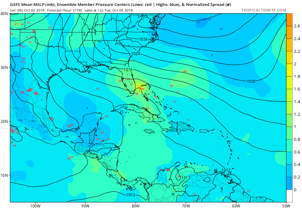
The GFS ensembles show several around the vicinity of South Florida in a week:
0 likes
-
Hypercane_Kyle

- Category 5
- Posts: 3465
- Joined: Sat Mar 07, 2015 7:58 pm
- Location: Cape Canaveral, FL
Re: Broad area of disturbed weather in the southwestern Caribbean Sea
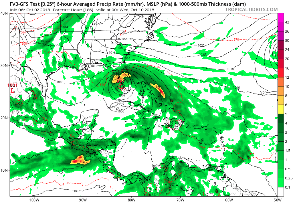
Worth noting the strongest ECMWF ensemble members are basically showing what the FV3-GFS is showing.
0 likes
My posts are my own personal opinion, defer to the National Hurricane Center (NHC) and other NOAA products for decision making during hurricane season.
-
gatorcane
- S2K Supporter
- Posts: 23708
- Age: 48
- Joined: Sun Mar 13, 2005 3:54 pm
- Location: Boca Raton, FL
Re: Broad area of disturbed weather in the southwestern Caribbean Sea
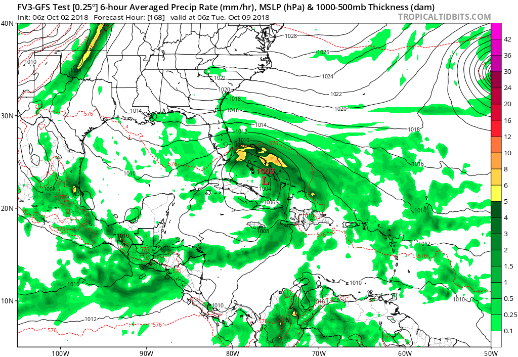
FV3 GFS into South Florida with a messy system but looks to be organizing:
0 likes
Who is online
Users browsing this forum: Teban54 and 227 guests