CPAC: WALAKA - Post-Tropical
Moderator: S2k Moderators
-
CrazyC83
- Professional-Met

- Posts: 34311
- Joined: Tue Mar 07, 2006 11:57 pm
- Location: Deep South, for the first time!
Re: CPAC: WALAKA - Hurricane
I'm guessing the peak intensity will be placed at 1800Z at 145 kt. ERC, upwelling or a touch of shear?
0 likes


Re: CPAC: WALAKA - Hurricane
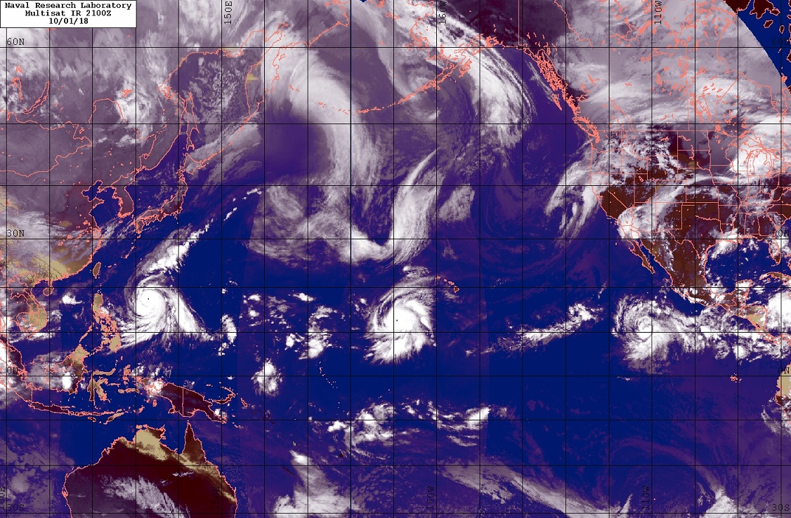
Cat 5 pair in the Western and Central Pacific
10 likes
The above post and any post by Ntxw is NOT an official forecast and should not be used as such. It is just the opinion of the poster and may or may not be backed by sound meteorological data. It is NOT endorsed by any professional institution including Storm2k. For official information, please refer to NWS products.
Help support Storm2K!

-
1900hurricane

- Category 5

- Posts: 6063
- Age: 34
- Joined: Fri Feb 06, 2015 12:04 pm
- Location: Houston, TX
- Contact:
Re: CPAC: WALAKA - Hurricane
I might have to look into the rarity of two simultaneous Pacific category 5s on either side of the International Date Line. It's possible this is a first time event.
7 likes
Contract Meteorologist. TAMU & MSST. Fiercely authentic, one of a kind. We are all given free will, so choose a life meant to be lived. We are the Masters of our own Stories.
Opinions expressed are mine alone.
Follow me on Twitter at @1900hurricane : Read blogs at https://1900hurricane.wordpress.com/
Opinions expressed are mine alone.
Follow me on Twitter at @1900hurricane : Read blogs at https://1900hurricane.wordpress.com/
-
bob rulz
- Category 5
- Posts: 1711
- Age: 35
- Joined: Sat Jan 28, 2006 7:30 pm
- Location: Salt Lake City, Utah
Re: CPAC: WALAKA - Hurricane
I did a quick check by looking for when East or Central Pacific hurricanes were at category 5 intensity, and cross-referencing them with the West Pacific (easier to look at the East Pacific first since cat 5 storms are much rarer there). The only thing I found that was close was on October 18, 2009, when Hurricane Rick was at 155kt at 1200Z and 140kt at 1800Z, and Typhoon Lupit was at 135kt according to the JTWC (so close!). This also shows Lupit reaching 140kt at 0Z on 10/19, but Rick had fallen to 125kt.
Hurricane Rick: https://www.nhc.noaa.gov/data/tcr/EP202009_Rick.pdf
Typhoon Lupit: http://www.metoc.navy.mil/jtwc/jtwc.htm ... rn-pacific (storm #22 of 2009 in the .zip file)
Feel free to let us know if you find anything else though, since my research wasn't particularly exhaustive! Either way, this is for sure a moment to be remembered if you're into historical tropical cyclone facts.
Last edited by bob rulz on Tue Oct 02, 2018 12:18 am, edited 1 time in total.
5 likes
-
HurricaneRyan
- Category 3

- Posts: 844
- Age: 32
- Joined: Sun Dec 05, 2010 3:05 pm
Re: CPAC: WALAKA - Hurricane
Still looks great not bothering anybody.
4 likes
The above post and any post by Ntxw is NOT an official forecast and should not be used as such. It is just the opinion of the poster and may or may not be backed by sound meteorological data. It is NOT endorsed by any professional institution including Storm2k. For official information, please refer to NWS products.
Help support Storm2K!
Help support Storm2K!

Re: CPAC: WALAKA - Hurricane
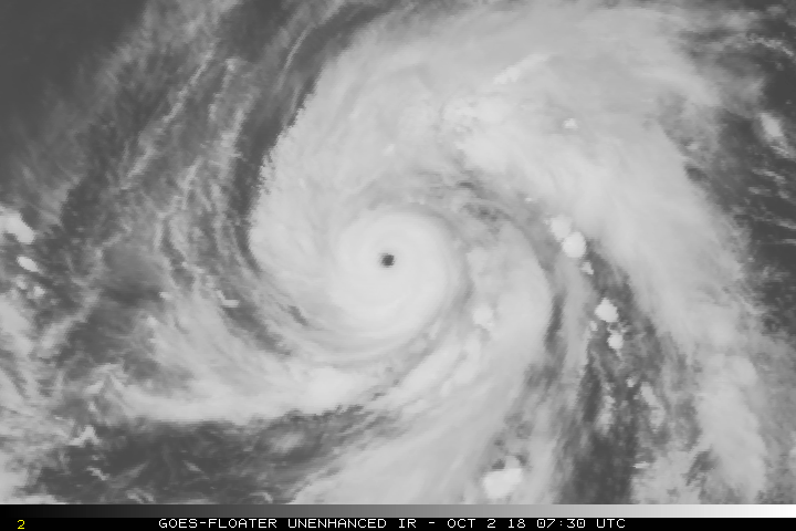
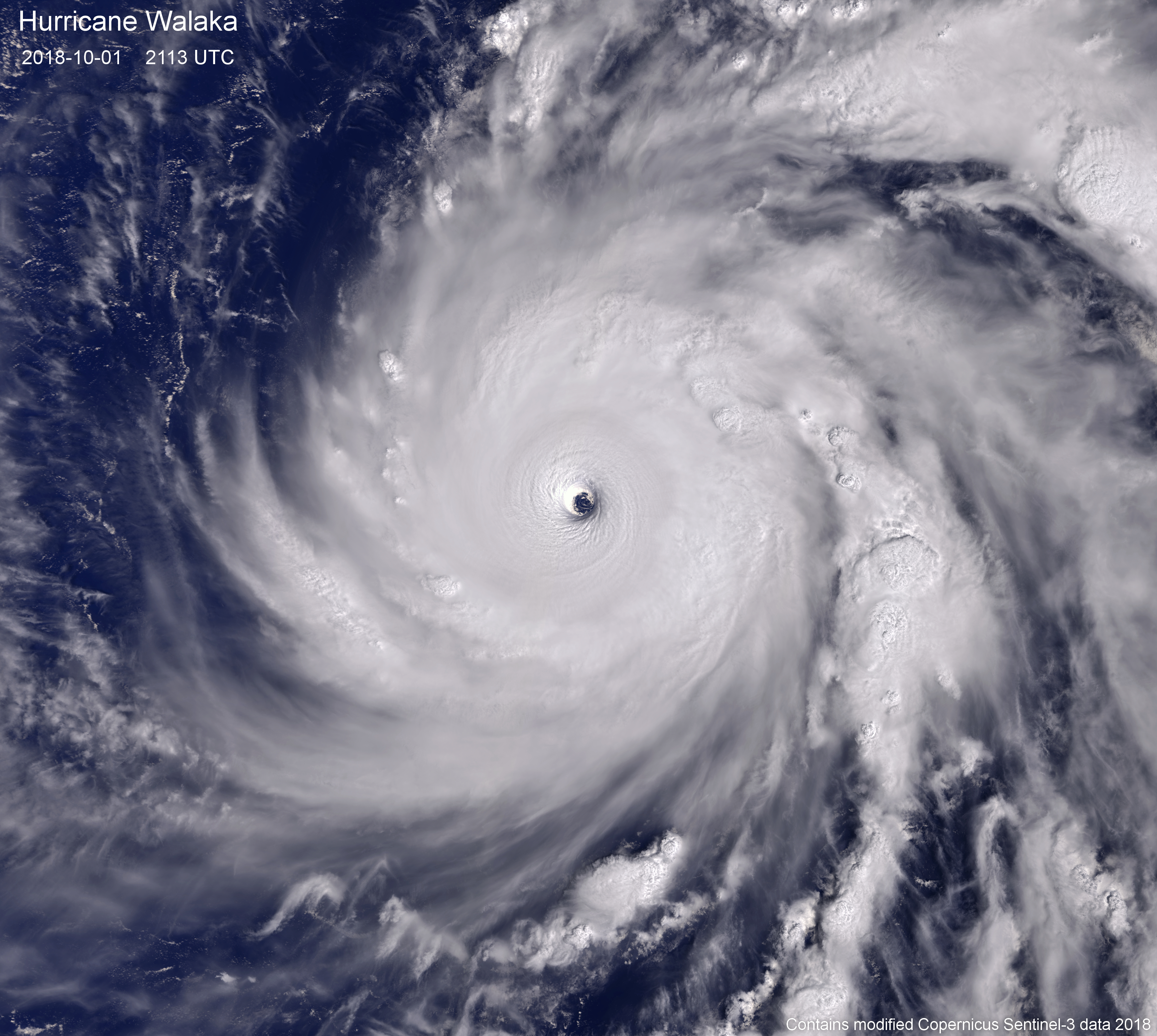
Well, this has to be one of my favourite Sentinel-3 images so far. Absolutely stunning storm!
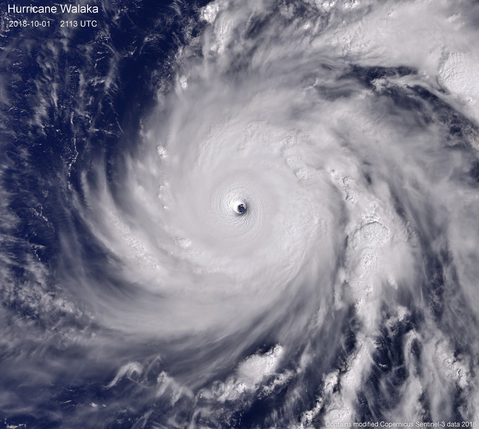
Close-up of the CDO:

Maximum resolution of the eye:

Here is the link to the original full-resolution image (3480 x 3116 px): https://c2.staticflickr.com/2/1963/31178804578_d3f80ca3f1_o.png
Close-up of the CDO:
Maximum resolution of the eye:
Here is the link to the original full-resolution image (3480 x 3116 px): https://c2.staticflickr.com/2/1963/31178804578_d3f80ca3f1_o.png
13 likes
-
hurricanes1234
- Category 5
- Posts: 2908
- Joined: Sat Jul 28, 2012 6:19 pm
- Location: Trinidad and Tobago
Re: CPAC: WALAKA - Hurricane
Just look at the absolutely perfect clarity of that eye. Thanks a lot for sharing that image!
Also, thanks to Chris90 and Highteeld for the links to the image sites yesterday.
Also, thanks to Chris90 and Highteeld for the links to the image sites yesterday.
2 likes
PLEASE NOTE: With the exception of information from weather agencies that I may copy and paste here, my posts will NEVER be official, since I am NOT a meteorologist. They are solely my amateur opinion, and may or may not be accurate. Therefore, please DO NOT use them as official details, particularly when making important decisions. Thank you.


Re: CPAC: WALAKA - Hurricane
Cat 5 ?
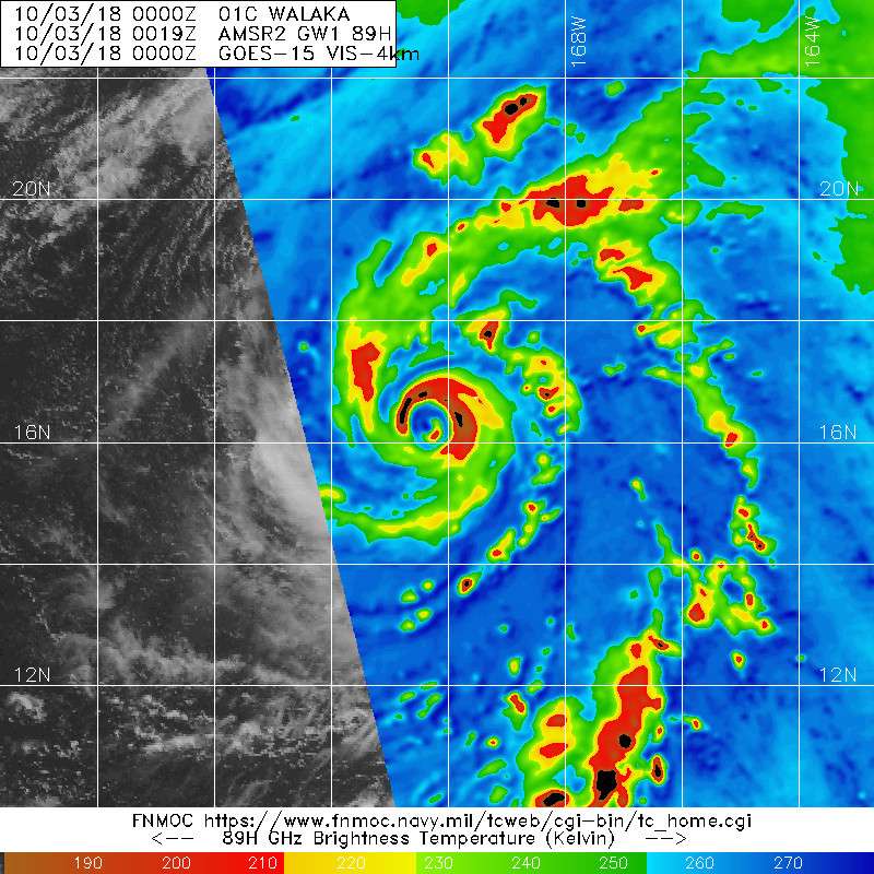
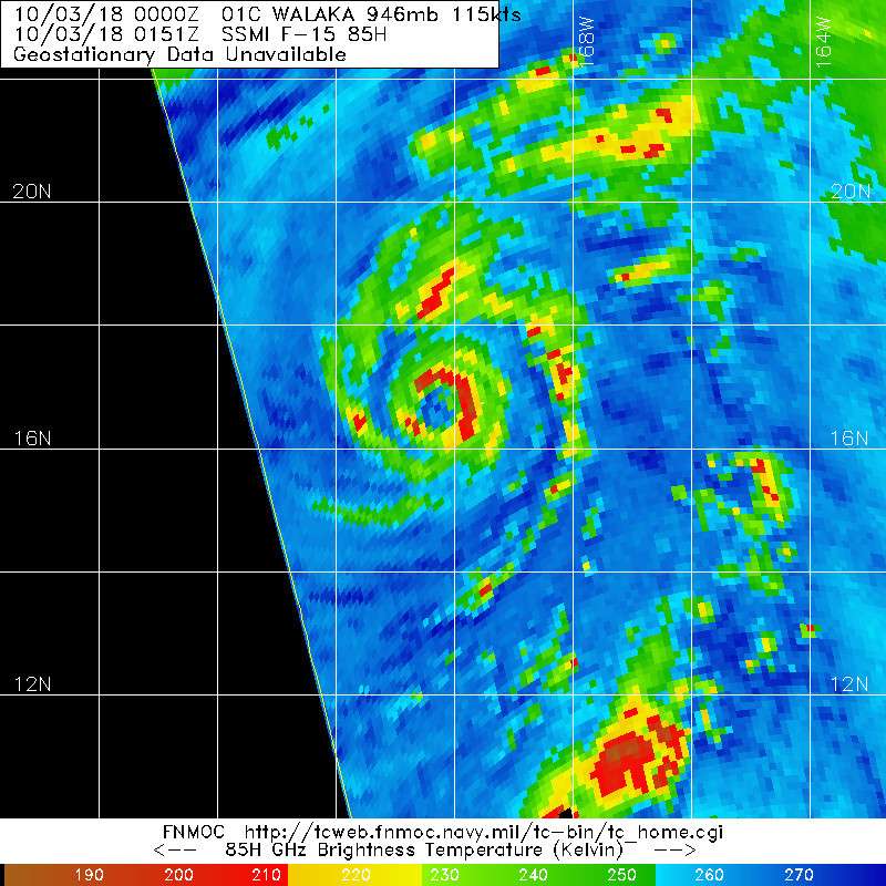
...WALAKA WEAKENS SLIGHTLY BUT REMAINS A DANGEROUS CATEGORY 5
HURRICANE HEADING TOWARD JOHNSTON ISLAND...
SUMMARY OF 500 AM HST...1500 UTC...INFORMATION
----------------------------------------------
LOCATION...14.7N 170.0W
ABOUT 140 MI...230 KM SSW OF JOHNSTON ISLAND
ABOUT 915 MI...1475 KM WSW OF HONOLULU HAWAII
MAXIMUM SUSTAINED WINDS...155 MPH...250 KM/H
PRESENT MOVEMENT...N OR 350 DEGREES AT 10 MPH...17 KM/H
MINIMUM CENTRAL PRESSURE...927 MB...27.38 INCHES
2 likes
-
storm_in_a_teacup

- Category 1

- Posts: 496
- Age: 33
- Joined: Wed Aug 16, 2017 5:01 pm
- Location: Huntsville, Alabama (originally from Houston)
- Contact:
Re: CPAC: WALAKA - Hurricane
WAcyclone wrote:Well, this has to be one of my favourite Sentinel-3 images so far. Absolutely stunning storm!
https://c2.staticflickr.com/2/1963/31178804578_27b971bc7f_h.jpg
Close-up of the CDO:
https://c2.staticflickr.com/2/1973/45050938971_64e71bb953_o.jpg
Maximum resolution of the eye:
https://i.imgur.com/AJLZ88d.jpg
Here is the link to the original full-resolution image (3480 x 3116 px): https://c2.staticflickr.com/2/1963/31178804578_d3f80ca3f1_o.png
Aaaaaaah! So fluffy! It’s like a vortex of angry down pillows!
The swirls in the eye even make it look like an eye. Definitely saving this one as a reference for art purposes!
5 likes
I know I can't straddle the atmosphere...just a tiny storm in your teacup, girl.
-
shiny-pebble
- Category 1
- Posts: 299
- Joined: Thu Jul 05, 2018 1:38 pm
Re: CPAC: WALAKA - Hurricane
Is something wrong on my end or has the latest advisory not been posted yet?
Sent from my LG-H700 using Tapatalk
Sent from my LG-H700 using Tapatalk
0 likes
Not an meteorologist! Just someone who is interested in weather. Please refer to the NHC and local weather officials to make decisions.
-Jack
-Jack
-
AnnularCane

- S2K Supporter

- Posts: 2949
- Joined: Thu Jun 08, 2006 9:18 am
- Location: Wytheville, VA
Re: CPAC: WALAKA - Hurricane
storm_in_a_teacup wrote:WAcyclone wrote:Well, this has to be one of my favourite Sentinel-3 images so far. Absolutely stunning storm!
https://c2.staticflickr.com/2/1963/31178804578_27b971bc7f_h.jpg
Close-up of the CDO:
https://c2.staticflickr.com/2/1973/45050938971_64e71bb953_o.jpg
Maximum resolution of the eye:
https://i.imgur.com/AJLZ88d.jpg
Here is the link to the original full-resolution image (3480 x 3116 px): https://c2.staticflickr.com/2/1963/31178804578_d3f80ca3f1_o.png
Aaaaaaah! So fluffy! It’s like a vortex of angry down pillows!
The swirls in the eye even make it look like an eye. Definitely saving this one as a reference for art purposes!
Someone's in love!
0 likes
-
storm_in_a_teacup
- Category 1
- Posts: 496
- Age: 33
- Joined: Wed Aug 16, 2017 5:01 pm
- Location: Huntsville, Alabama (originally from Houston)
- Contact:
Re: CPAC: WALAKA - Hurricane
AnnularCane wrote:storm_in_a_teacup wrote:WAcyclone wrote:Well, this has to be one of my favourite Sentinel-3 images so far. Absolutely stunning storm!
https://c2.staticflickr.com/2/1963/31178804578_27b971bc7f_h.jpg
Close-up of the CDO:
https://c2.staticflickr.com/2/1973/45050938971_64e71bb953_o.jpg
Maximum resolution of the eye:
https://i.imgur.com/AJLZ88d.jpg
Here is the link to the original full-resolution image (3480 x 3116 px): https://c2.staticflickr.com/2/1963/31178804578_d3f80ca3f1_o.png
Aaaaaaah! So fluffy! It’s like a vortex of angry down pillows!
The swirls in the eye even make it look like an eye. Definitely saving this one as a reference for art purposes!
Someone's in love!
I mean, sometimes I wonder what I would look like if I wasn't confined to the teacup
[please forgive me]
3 likes
I know I can't straddle the atmosphere...just a tiny storm in your teacup, girl.
-
AnnularCane
- S2K Supporter
- Posts: 2949
- Joined: Thu Jun 08, 2006 9:18 am
- Location: Wytheville, VA
Re: CPAC: WALAKA - Hurricane
storm_in_a_teacup wrote:AnnularCane wrote:storm_in_a_teacup wrote:
Aaaaaaah! So fluffy! It’s like a vortex of angry down pillows!
The swirls in the eye even make it look like an eye. Definitely saving this one as a reference for art purposes!
Someone's in love!
I mean, sometimes I wonder what I would look like if I wasn't confined to the teacup
[please forgive me]
You're forgiven.
1 likes
-
mrbagyo

- Category 5
- Posts: 3963
- Age: 33
- Joined: Thu Apr 12, 2012 9:18 am
- Location: 14.13N 120.98E
- Contact:
Re: CPAC: WALAKA - Hurricane
Eyewall replacement is almost Done!
1 likes
The posts in this forum are NOT official forecast and should not be used as such. They are just the opinion of the poster and may or may not be backed by sound meteorological data. They are NOT endorsed by any professional institution or storm2k.org. For official information, please refer to RSMC, NHC and NWS products.
-
mrbagyo
- Category 5
- Posts: 3963
- Age: 33
- Joined: Thu Apr 12, 2012 9:18 am
- Location: 14.13N 120.98E
- Contact:
Re: CPAC: WALAKA - Hurricane
ERC complete
Let's see Walaka's one last Hurrah

Let's see Walaka's one last Hurrah
1 likes
The posts in this forum are NOT official forecast and should not be used as such. They are just the opinion of the poster and may or may not be backed by sound meteorological data. They are NOT endorsed by any professional institution or storm2k.org. For official information, please refer to RSMC, NHC and NWS products.
-
mrbagyo
- Category 5
- Posts: 3963
- Age: 33
- Joined: Thu Apr 12, 2012 9:18 am
- Location: 14.13N 120.98E
- Contact:
Re: CPAC: WALAKA - Hurricane
Raw T now up to 7.1 again
What a Comeback
What a Comeback
0 likes
The posts in this forum are NOT official forecast and should not be used as such. They are just the opinion of the poster and may or may not be backed by sound meteorological data. They are NOT endorsed by any professional institution or storm2k.org. For official information, please refer to RSMC, NHC and NWS products.
-
mrbagyo
- Category 5
- Posts: 3963
- Age: 33
- Joined: Thu Apr 12, 2012 9:18 am
- Location: 14.13N 120.98E
- Contact:
Re: CPAC: WALAKA - Hurricane
Probably between 130-135 knots again
0 likes
The posts in this forum are NOT official forecast and should not be used as such. They are just the opinion of the poster and may or may not be backed by sound meteorological data. They are NOT endorsed by any professional institution or storm2k.org. For official information, please refer to RSMC, NHC and NWS products.
-
mrbagyo
- Category 5
- Posts: 3963
- Age: 33
- Joined: Thu Apr 12, 2012 9:18 am
- Location: 14.13N 120.98E
- Contact:
Re: CPAC: WALAKA - Hurricane
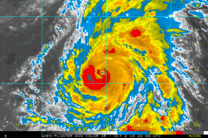
Current Intensity Analysis
UW - CIMSS
ADVANCED DVORAK TECHNIQUE
ADT-Version 9.0
Tropical Cyclone Intensity Algorithm
----- Current Analysis -----
Date : 03 OCT 2018 Time : 090000 UTC
Lat : 17:57:00 N Lon : 170:04:48 W
CI# /Pressure/ Vmax
6.9 / 921.2mb/137.4kt
Final T# Adj T# Raw T#
6.9 7.1 7.1
Estimated radius of max. wind based on IR : 28 km
Center Temp : +12.2C Cloud Region Temp : -73.8C
Scene Type : EYE
Subtropical Adjustment : OFF
Extratropical Adjustment : OFF
Positioning Method : ARCHER POSITIONING
Ocean Basin : EAST PACIFIC
Dvorak CI > MSLP Conversion Used : CKZ Method
Tno/CI Rules : Constraint Limits : NO LIMIT
Weakening Flag : OFF
Rapid Dissipation Flag : OFF
C/K/Z MSLP Estimate Inputs :
- Average 34 knot radii : 135nmi
- Environmental MSLP : 1007mb
Satellite Name : GOES15
Satellite Viewing Angle : 45.0 degrees
0 likes
The posts in this forum are NOT official forecast and should not be used as such. They are just the opinion of the poster and may or may not be backed by sound meteorological data. They are NOT endorsed by any professional institution or storm2k.org. For official information, please refer to RSMC, NHC and NWS products.
Re: CPAC: WALAKA - Hurricane
Being underestimated. CPHC goes with 115 knots and doesn't forecast any strengthening
Hurricane Walaka Discussion Number 15...Corrected
NWS Central Pacific Hurricane Center Honolulu HI CP012018
1100 PM HST Tue Oct 02 2018
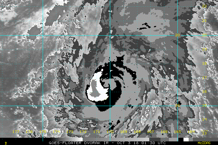
Walaka's eye remains somewhat ragged in infrared satellite imagery
early this evening. However, a 0528Z SSMS pass continued to show a
well defined eye surrounded by a complete eyewall. The degradation
of the system in conventional satellite imagery is likely the
result of increasing vertical wind shear from the southwest. The
latest subjective Dvorak current intensity estimates from JTWC and
PHFO were 6.0/115 kt and 5.5/102 kt from SAB. The UW-CIMSS ADT
estimate was also 6.0/115 kt. Based on these estimates, we will
maintain Walaka's initial intensity at 115 kt for this advisory.
The initial motion for this advisory is 005/11 kt. Walaka is being
steered towards a vertically-stacked low pressure area near 31N
170W. Walaka is expected to soon begin accelerating toward the
north-northeast as it gets caught up in the outer circulation along
the southeastern and eastern periphery of this deep low. Once Walaka
gets closer to this extratropical feature, the track guidance
indicates its forward motion will slow in the 36 to 48 hour time.
It may make a brief bend back toward the north-northwest, then track
rapidly northeastward between 72 and 96 hours as the circulation
becomes more shallow. The track guidance remains in remarkably good
agreement considering the rather complex interaction between Walaka
and the extratropical low. This latest track forecast is very close
to the previous advisory package.
As the vertical wind shear near Walaka becomes increasingly hostile
during the next 24 to 36 hours, steady weakening is forecast.
Although the shear diminishes somewhat beyond 36 hours, the tropical
cyclone will begin moving over increasingly cool sea surface
temperatures and reduced ocean heat content. There is some
uncertainty about how Walaka's interaction with the extratropical
low will affect its intensity. The global models seem to be in good
agreement that some semblance of a warm core system will remain
after Walaka interaction with the extratropical low. Therefore, the
current forecast maintains Walaka as a tropical cyclone through 96
hours. It would not be surprising if the system becomes
extratropical sooner. The latest intensity forecast shows a slower
rate of weakening than most of the dynamical models, which is in
best agreement with the ECMWF through 48 hours, then aligns with the
SHIPS guidance afterward. The current intensity forecast is also
very close to the previous advisory package.
FORECAST POSITIONS AND MAX WINDS
INIT 03/0900Z 18.1N 170.0W 115 KT 130 MPH
12H 03/1800Z 20.4N 169.2W 110 KT 125 MPH
24H 04/0600Z 23.9N 167.8W 105 KT 120 MPH
36H 04/1800Z 27.5N 167.1W 90 KT 105 MPH
48H 05/0600Z 29.9N 167.4W 80 KT 90 MPH
72H 06/0600Z 33.5N 165.0W 60 KT 70 MPH
96H 07/0600Z 41.5N 158.5W 50 KT 60 MPH
120H 08/0600Z 51.0N 146.0W 30 KT 35 MPH...POST-TROP/EXTRATROP
$$
Forecaster Houston
NWS Central Pacific Hurricane Center Honolulu HI CP012018
1100 PM HST Tue Oct 02 2018
Walaka's eye remains somewhat ragged in infrared satellite imagery
early this evening. However, a 0528Z SSMS pass continued to show a
well defined eye surrounded by a complete eyewall. The degradation
of the system in conventional satellite imagery is likely the
result of increasing vertical wind shear from the southwest. The
latest subjective Dvorak current intensity estimates from JTWC and
PHFO were 6.0/115 kt and 5.5/102 kt from SAB. The UW-CIMSS ADT
estimate was also 6.0/115 kt. Based on these estimates, we will
maintain Walaka's initial intensity at 115 kt for this advisory.
The initial motion for this advisory is 005/11 kt. Walaka is being
steered towards a vertically-stacked low pressure area near 31N
170W. Walaka is expected to soon begin accelerating toward the
north-northeast as it gets caught up in the outer circulation along
the southeastern and eastern periphery of this deep low. Once Walaka
gets closer to this extratropical feature, the track guidance
indicates its forward motion will slow in the 36 to 48 hour time.
It may make a brief bend back toward the north-northwest, then track
rapidly northeastward between 72 and 96 hours as the circulation
becomes more shallow. The track guidance remains in remarkably good
agreement considering the rather complex interaction between Walaka
and the extratropical low. This latest track forecast is very close
to the previous advisory package.
As the vertical wind shear near Walaka becomes increasingly hostile
during the next 24 to 36 hours, steady weakening is forecast.
Although the shear diminishes somewhat beyond 36 hours, the tropical
cyclone will begin moving over increasingly cool sea surface
temperatures and reduced ocean heat content. There is some
uncertainty about how Walaka's interaction with the extratropical
low will affect its intensity. The global models seem to be in good
agreement that some semblance of a warm core system will remain
after Walaka interaction with the extratropical low. Therefore, the
current forecast maintains Walaka as a tropical cyclone through 96
hours. It would not be surprising if the system becomes
extratropical sooner. The latest intensity forecast shows a slower
rate of weakening than most of the dynamical models, which is in
best agreement with the ECMWF through 48 hours, then aligns with the
SHIPS guidance afterward. The current intensity forecast is also
very close to the previous advisory package.
FORECAST POSITIONS AND MAX WINDS
INIT 03/0900Z 18.1N 170.0W 115 KT 130 MPH
12H 03/1800Z 20.4N 169.2W 110 KT 125 MPH
24H 04/0600Z 23.9N 167.8W 105 KT 120 MPH
36H 04/1800Z 27.5N 167.1W 90 KT 105 MPH
48H 05/0600Z 29.9N 167.4W 80 KT 90 MPH
72H 06/0600Z 33.5N 165.0W 60 KT 70 MPH
96H 07/0600Z 41.5N 158.5W 50 KT 60 MPH
120H 08/0600Z 51.0N 146.0W 30 KT 35 MPH...POST-TROP/EXTRATROP
$$
Forecaster Houston
0 likes
Who is online
Users browsing this forum: No registered users and 100 guests