Broad area of disturbed weather in the Western Caribbean Sea (Is INVEST 91L)

This is the general tropical discussion area. Anyone can take their shot at predicting a storms path.

Moderator: S2k Moderators

Forum rules

The posts in this forum are NOT official forecasts and should not be used as such. They are just the opinion of the poster and may or may not be backed by sound meteorological data. They are NOT endorsed by any professional institution or STORM2K. For official information, please refer to products from the National Hurricane Center and National Weather Service.

Help Support Storm2K
Message
Author
User avatar
boca
Category 5
Category 5
Posts: 6367
Age: 60
Joined: Mon Dec 15, 2003 8:49 am
Location: Boca Raton,FL

Re: Broad area of disturbed weather in the Western Caribbean Sea

#641 Postby boca » Thu Oct 04, 2018 12:48 pm

TheStormExpert wrote:
sunnyday wrote:So, has Fl dodged another bullet?

Definitely not. Climatology a track towards FL would be favored in October. Though I think anywhere west of Pensacola is a highest risk at the moment.


I think South Florida is probably the least likely to get this, but we still have to watch since it’s October. To be politically correct no one is out of the woods,just my personal opinion.
Last edited by boca on Thu Oct 04, 2018 12:53 pm, edited 1 time in total.
0 likes   

User avatar
toad strangler
S2K Supporter
S2K Supporter
Posts: 4543
Joined: Sun Jul 28, 2013 3:09 pm
Location: Earth
Contact:

Re: Broad area of disturbed weather in the Western Caribbean Sea

#642 Postby toad strangler » Thu Oct 04, 2018 12:50 pm

I certainly don't have the balls to declare any area over another without a storm yet.
3 likes   

User avatar
blp
Category 5
Category 5
Posts: 2840
Age: 46
Joined: Thu Sep 09, 2004 7:51 pm
Location: Miami, FL
Contact:

Re: Broad area of disturbed weather in the Western Caribbean Sea

#643 Postby blp » Thu Oct 04, 2018 12:51 pm

Still offshore. Will it put the brakes or head inland. Next few hours are key.

https://col.st/H49Rs
1 likes   
The following post is NOT an official forecast and should not be used as such. It is just the opinion of the poster and may or may not be backed by sound meteorological data. It is NOT endorsed by any professional institution including storm2k.org For Official Information please refer to the NHC and NWS products.

Aric Dunn
Category 5
Category 5
Posts: 21238
Age: 42
Joined: Sun Sep 19, 2004 9:58 pm
Location: Ready for the Chase.
Contact:

Re: Broad area of disturbed weather in the Western Caribbean Sea

#644 Postby Aric Dunn » Thu Oct 04, 2018 12:52 pm

blp wrote:Still offshore.

https://col.st/H49Rs

.
it will be shortly and it is weakening. start looking to the east.
1 likes   
Note: If I make a post that is brief. Please refer back to previous posts for the analysis or reasoning. I do not re-write/qoute what my initial post said each time.
If there is nothing before... then just ask :)

Space & Atmospheric Physicist, Embry-Riddle Aeronautical University,
I believe the sky is falling...

TheStormExpert

Re: Broad area of disturbed weather in the Western Caribbean Sea

#645 Postby TheStormExpert » Thu Oct 04, 2018 12:53 pm

Up to 40% @ 5 days on the 2pm TWO.

Tropical Weather Outlook
NWS National Hurricane Center Miami FL
200 PM EDT Thu Oct 4 2018

For the North Atlantic...Caribbean Sea and the Gulf of Mexico:

The National Hurricane Center is issuing advisories on Hurricane
Leslie, located over the central Atlantic Ocean.

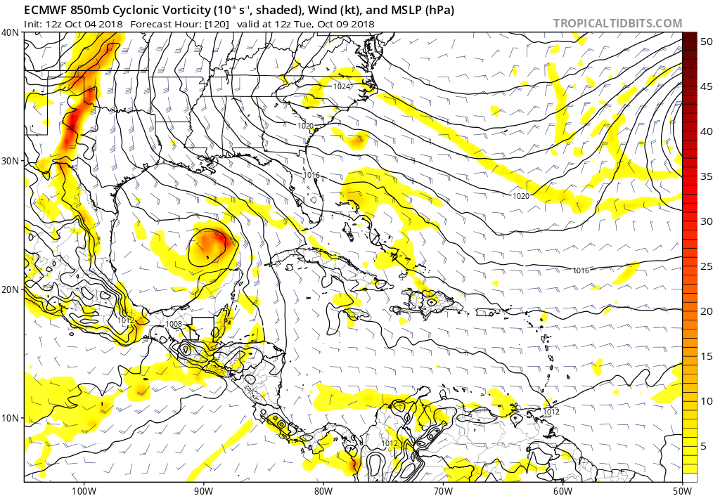
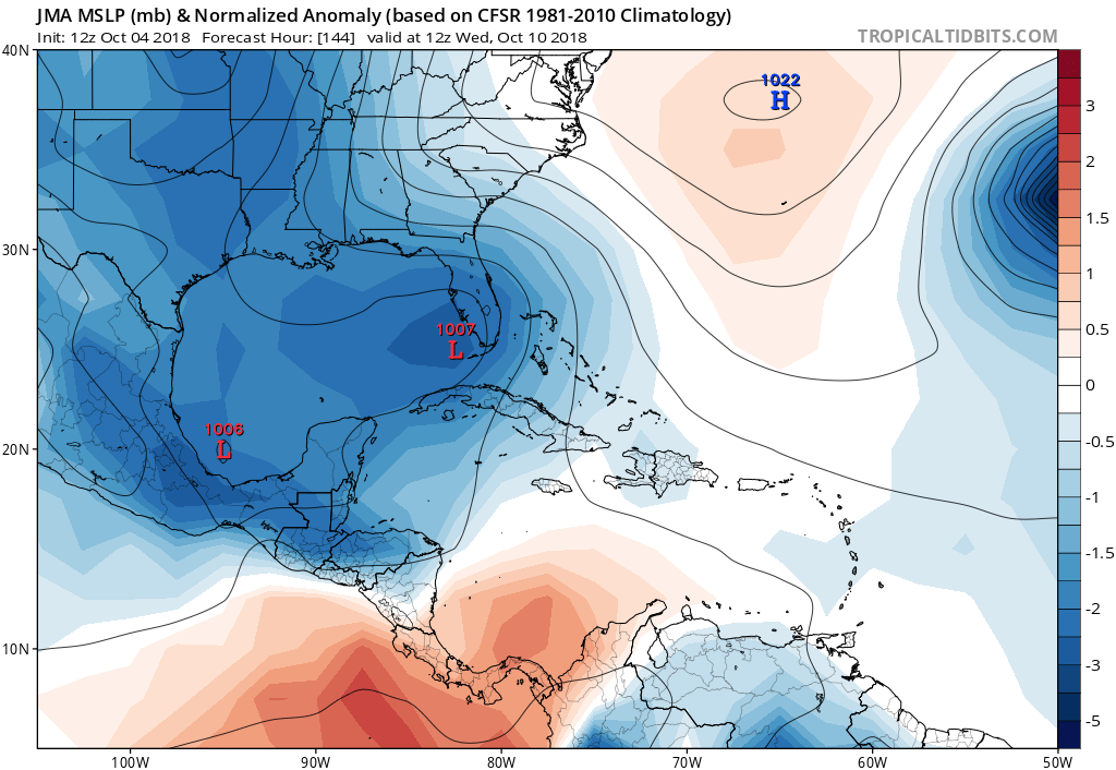
1. A broad low pressure area centered near the northeastern coasts of
Nicaragua and Honduras is producing an extensive area of
disorganized clouds and thunderstorms over the central and western
Caribbean Sea, as well as portions of Central America. While
surface pressures are relatively low in the area, upper-level winds
are currently not favorable for tropical cyclone formation.
Environmental conditions could become less hostile by late this
weekend or early next week, and a tropical depression could form as
the system moves slowly northwestward across the northwestern
Caribbean Sea and the southern Gulf of Mexico.
* Formation chance through 48 hours...low...near 0 percent.
* Formation chance through 5 days...medium...40 percent.

Forecaster Beven


Image
0 likes   

User avatar
SFLcane
S2K Supporter
S2K Supporter
Posts: 10163
Age: 47
Joined: Sat Jun 05, 2010 1:44 pm
Location: Lake Worth Florida

Re: Broad area of disturbed weather in the Western Caribbean Sea

#646 Postby SFLcane » Thu Oct 04, 2018 12:55 pm

toad strangler wrote:I certainly don't have the balls to declare any area over another without a storm yet.


Has Florida dogged another bullet? There isn’t even a well defined surface low as of yet like come on. If you want to get threatened by a tropical just in sfl sw Caribbean is your prime spot in October. Let’s get a full fletched tc going first before we start saying it’s heading towards the gulfcoast etc. still plenty of shear this will most likely be a very lobsided system with most of its weather to the east.
0 likes   

User avatar
SoupBone
Category 5
Category 5
Posts: 3111
Joined: Tue Sep 20, 2005 5:24 pm

Re: Broad area of disturbed weather in the Western Caribbean Sea

#647 Postby SoupBone » Thu Oct 04, 2018 1:03 pm

So where's our weather history experts today? When's the last time, the western and central gulf coast did not see a single cool/cold front of substance in October?
0 likes   
Personal Forecast Disclaimer:
The posts in this forum are NOT official forecast and should not be used as such. They are just the opinion of the poster and may or may not be backed by sound meteorological data. They are NOT endorsed by any professional institution or storm2k.org. For official information, please refer to the NHC and NWS products.

fox13weather
Professional-Met
Professional-Met
Posts: 161
Joined: Tue Sep 20, 2005 7:49 pm

Re: Broad area of disturbed weather in the Western Caribbean Sea

#648 Postby fox13weather » Thu Oct 04, 2018 1:13 pm

SoupBone wrote:So where's our weather history experts today? When's the last time, the western and central gulf coast did not see a single cool/cold front of substance in October?


Not unusual at all to not have a cold front until mid to late October. All it takes is a ridge in the southeast, which there is now, and have been many times in the past....
1 likes   

AutoPenalti
Category 5
Category 5
Posts: 4030
Age: 29
Joined: Mon Aug 17, 2015 4:16 pm
Location: Ft. Lauderdale, Florida

Re: Broad area of disturbed weather in the Western Caribbean Sea

#649 Postby AutoPenalti » Thu Oct 04, 2018 1:19 pm

sunnyday wrote:So, has Fl dodged another bullet?

Umm, no. This is still 10+ days out...
1 likes   
The posts in this forum are NOT official forecasts and should not be used as such. They are just the opinion of the poster and may or may not be backed by sound meteorological data. They are NOT endorsed by any professional institution or STORM2K. For official information, please refer to products from the NHC and NWS.


Model Runs Cheat Sheet:
GFS (5:30 AM/PM, 11:30 AM/PM)
HWRF, GFDL, UKMET, NAVGEM (6:30-8:00 AM/PM, 12:30-2:00 AM/PM)
ECMWF (1:45 AM/PM)

TCVN
is a weighted averaged

User avatar
gatorcane
S2K Supporter
S2K Supporter
Posts: 23691
Age: 47
Joined: Sun Mar 13, 2005 3:54 pm
Location: Boca Raton, FL

Re: Broad area of disturbed weather in the Western Caribbean Sea

#650 Postby gatorcane » Thu Oct 04, 2018 1:19 pm

Looks like it could end up similar to Nate of last year where the ridge protected peninsula Florida even in October:

Image
0 likes   

User avatar
gatorcane
S2K Supporter
S2K Supporter
Posts: 23691
Age: 47
Joined: Sun Mar 13, 2005 3:54 pm
Location: Boca Raton, FL

Re: Broad area of disturbed weather in the Western Caribbean Sea

#651 Postby gatorcane » Thu Oct 04, 2018 1:22 pm

Euro looks like it is ramping up in Southern Gulf:

Image
0 likes   

User avatar
tarheelprogrammer
S2K Supporter
S2K Supporter
Posts: 1793
Joined: Mon Mar 28, 2016 9:25 pm
Location: Raleigh, NC area (Garner, NC)

Re: Broad area of disturbed weather in the Western Caribbean Sea

#652 Postby tarheelprogrammer » Thu Oct 04, 2018 1:34 pm

gatorcane wrote:Euro looks like it is ramping up in Southern Gulf:

https://i.postimg.cc/DwytGmYt/ecmwf_uv850_vort_watl_6.png


Much weaker at 12z than 0z at hour 144 on the ECMWF.
0 likes   
My posts are not official forecasts. They are just my opinion and may or may not be backed by sound meteorological data. They are NOT endorsed by any professional institution or storm2k.org. For official information, please refer to the NHC and NWS products.

stormlover2013

Re: Broad area of disturbed weather in the Western Caribbean Sea

#653 Postby stormlover2013 » Thu Oct 04, 2018 1:37 pm

I could see that euro track if the cold front comes, that's climatology written all over it.
0 likes   

Aric Dunn
Category 5
Category 5
Posts: 21238
Age: 42
Joined: Sun Sep 19, 2004 9:58 pm
Location: Ready for the Chase.
Contact:

Re: Broad area of disturbed weather in the Western Caribbean Sea

#654 Postby Aric Dunn » Thu Oct 04, 2018 1:38 pm

tarheelprogrammer wrote:
gatorcane wrote:Euro looks like it is ramping up in Southern Gulf:

https://i.postimg.cc/DwytGmYt/ecmwf_uv850_vort_watl_6.png


Much weaker at 12z than 0z at hour 144 on the ECMWF.
.
Because it is much faster. by roughly 120 to 144 hours the 00z euro was still in the southern gulf.

12z it is already in northern gulf and turning.

this is because it initialized the current LLC that will die over land.

things are going to change quite a bit still with timing since we dont have a defined area yet.
3 likes   
Note: If I make a post that is brief. Please refer back to previous posts for the analysis or reasoning. I do not re-write/qoute what my initial post said each time.
If there is nothing before... then just ask :)

Space & Atmospheric Physicist, Embry-Riddle Aeronautical University,
I believe the sky is falling...

stormlover2013

Re: Broad area of disturbed weather in the Western Caribbean Sea

#655 Postby stormlover2013 » Thu Oct 04, 2018 1:40 pm

yeah this was a much quicker run and little more west
0 likes   

User avatar
Steve
S2K Supporter
S2K Supporter
Posts: 9620
Joined: Sat Apr 05, 2003 11:41 pm
Location: Not a state-caster

Re: Broad area of disturbed weather in the Western Caribbean Sea

#656 Postby Steve » Thu Oct 04, 2018 1:40 pm

blp wrote:12z Ukmet now inline with the others. Goes into the North Gulfcoast

NEW TROPICAL CYCLONE FORECAST TO DEVELOP AFTER 102 HOURS

FORECAST POSITION AT T+102 : 22.3N 91.8W

LEAD CENTRAL MAXIMUM WIND
VERIFYING TIME TIME POSITION PRESSURE (MB) SPEED (KNOTS)
-------------- ---- -------- ------------- -------------

0000UTC 09.10.2018 108 23.5N 92.3W 1001 32
1200UTC 09.10.2018 120 25.1N 92.1W 999 33
0000UTC 10.10.2018 132 28.4N 91.7W 996 40
1200UTC 10.10.2018 144 32.5N 90.5W 995 33


Looks significantly farther west than the EC/CMC solutions. It's more the Lili side of things.
0 likes   

User avatar
Steve
S2K Supporter
S2K Supporter
Posts: 9620
Joined: Sat Apr 05, 2003 11:41 pm
Location: Not a state-caster

Re: Broad area of disturbed weather in the Western Caribbean Sea

#657 Postby Steve » Thu Oct 04, 2018 1:45 pm

AutoPenalti wrote:
sunnyday wrote:So, has Fl dodged another bullet?

Umm, no. This is still 10+ days out...


I'm not disagreeing with you, but I don't think it's 10+ days at this point - more like 7/8.
0 likes   

User avatar
gatorcane
S2K Supporter
S2K Supporter
Posts: 23691
Age: 47
Joined: Sun Mar 13, 2005 3:54 pm
Location: Boca Raton, FL

Re: Broad area of disturbed weather in the Western Caribbean Sea

#658 Postby gatorcane » Thu Oct 04, 2018 1:48 pm

Low-resolution JMA has a more climatological track into SW Florida heading NNE:

Image
0 likes   

stormlover2013

Re: Broad area of disturbed weather in the Western Caribbean Sea

#659 Postby stormlover2013 » Thu Oct 04, 2018 1:50 pm

has center forming way way east of other models
0 likes   

User avatar
tarheelprogrammer
S2K Supporter
S2K Supporter
Posts: 1793
Joined: Mon Mar 28, 2016 9:25 pm
Location: Raleigh, NC area (Garner, NC)

Re: Broad area of disturbed weather in the Western Caribbean Sea

#660 Postby tarheelprogrammer » Thu Oct 04, 2018 1:51 pm

Aric Dunn wrote:
tarheelprogrammer wrote:
gatorcane wrote:Euro looks like it is ramping up in Southern Gulf:

https://i.postimg.cc/DwytGmYt/ecmwf_uv850_vort_watl_6.png


Much weaker at 12z than 0z at hour 144 on the ECMWF.
.
Because it is much faster. by roughly 120 to 144 hours the 00z euro was still in the southern gulf.

12z it is already in northern gulf and turning.

this is because it initialized the current LLC that will die over land.

things are going to change quite a bit still with timing since we dont have a defined area yet.


Oh okay, I didn't know. Still getting caught up. All I know is keep this away from the Carolinas. Thanks. :lol:
1 likes   
My posts are not official forecasts. They are just my opinion and may or may not be backed by sound meteorological data. They are NOT endorsed by any professional institution or storm2k.org. For official information, please refer to the NHC and NWS products.


Return to “Talkin' Tropics”

Who is online

Users browsing this forum: Cdenton12, cstrunk, Google Adsense [Bot], ouragans, Steve H., Ulf and 36 guests