Broad area of disturbed weather in the Western Caribbean Sea (Is INVEST 91L)

This is the general tropical discussion area. Anyone can take their shot at predicting a storms path.

Moderator: S2k Moderators

Forum rules

The posts in this forum are NOT official forecasts and should not be used as such. They are just the opinion of the poster and may or may not be backed by sound meteorological data. They are NOT endorsed by any professional institution or STORM2K. For official information, please refer to products from the National Hurricane Center and National Weather Service.

Help Support Storm2K
Message
Author
User avatar
Steve
S2K Supporter
S2K Supporter
Posts: 9620
Joined: Sat Apr 05, 2003 11:41 pm
Location: Not a state-caster

Re: Broad area of disturbed weather in the Western Caribbean Sea

#701 Postby Steve » Thu Oct 04, 2018 5:57 pm

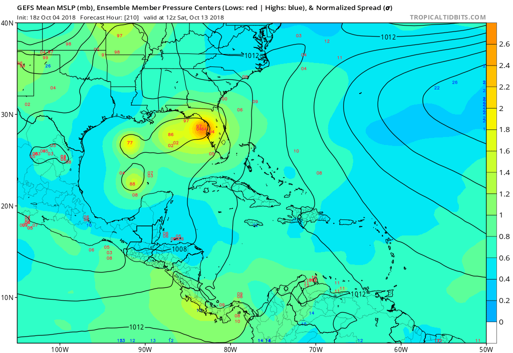
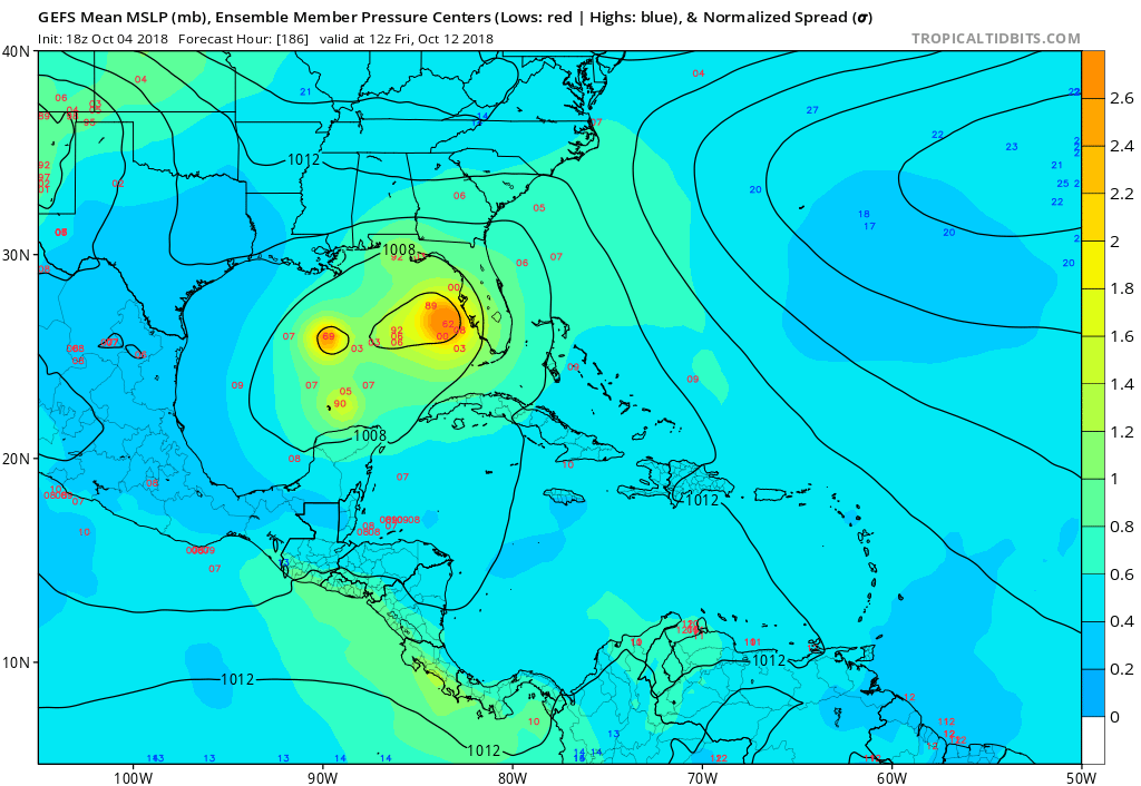
Dean4Storms wrote:Not liking the general solutions of a TC toward the upper Gulf Coast with me being just 10 miles east of Destin. Guess I need to prep the RV this weekend just in case we need to bug out.


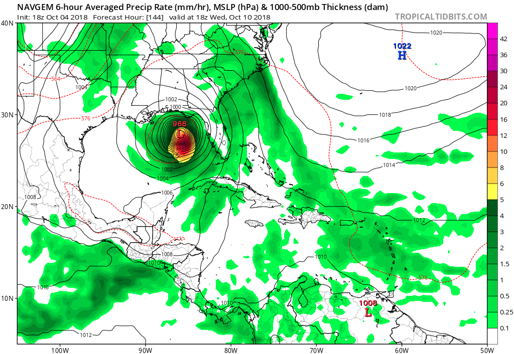
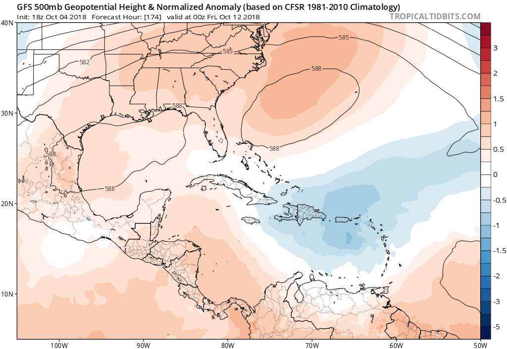
Prepping is the right thing to do,but the likelihood of anything stronger than a fading 2 would surprise me. NEward landfalling North Gulf solutions rarely are a grave threat into the fall. I think a higher end tropical storm or hurricane Cat 1 could be in the cards. But butted up against shear/a front, you could see something intensifying across the Gulf then weakening north of 26/27. Think Opal (but not starting as far west or as strong) which got to a 4 or so but over the loop current but fell off to a 3 landfalling. There were other processes at work with it because we had 50moh winds here due to the super tight isobars. It also, like Juan in 1985, ushered in the fall.

If you live in the RV, that’s a different situation obviously.
1 likes   

User avatar
wxman57
Moderator-Pro Met
Moderator-Pro Met
Posts: 22978
Age: 67
Joined: Sat Jun 21, 2003 8:06 pm
Location: Houston, TX (southwest)

Re: Broad area of disturbed weather in the Western Caribbean Sea

#702 Postby wxman57 » Thu Oct 04, 2018 6:01 pm

AutoPenalti wrote:
robbielyn wrote:
boca wrote:South Florida is in the safe zone according to wxman57.We could use the rain.
maybe on your side of the coast but not the west side

That's a pretty bold statement for something this far out in time and has yet to develop some sort of LLC.


I'm just making a forecast based on the best-available information. I've been forecasting tropical cyclones worldwide since 1980, before most of the members here were alive. Our clients have to take actions up to 7-10 days ahead of a possible impact (not a guaranteed impact). We cannot wait until recon flies out there Monday afternoon and finds a depression to make a forecast. All indications are that the high pressure along the east U.S. coast will be strong enough to keep it west of the FL Peninsula. Even if the high wasn't strong enough and the disturbance tracked near S. FL, all that Florida would get would be rain as it moved across Cuba into S. Florida. They may still get rain as it passes well west. Not much of a chance to develop if it doesn't cross the Gulf. I'm just not concerned about a TS or H hitting south Florida. I know we can't be 100% confident until it develops and is heading for land, but the odds are pretty good that south FL is going to be OK.
13 likes   

User avatar
SFLcane
S2K Supporter
S2K Supporter
Posts: 10163
Age: 47
Joined: Sat Jun 05, 2010 1:44 pm
Location: Lake Worth Florida

Re: Broad area of disturbed weather in the Western Caribbean Sea

#703 Postby SFLcane » Thu Oct 04, 2018 6:13 pm

Thx 57 that high pressure system has been parked across the southeast for weeks. If this waits to develop till the gulf it may never amount to much other then a weak sheared T.S. As you have been stating that shear in the gulf and Caribbean is not going anywhere.
1 likes   

User avatar
cycloneye
Admin
Admin
Posts: 145292
Age: 68
Joined: Thu Oct 10, 2002 10:54 am
Location: San Juan, Puerto Rico

Re: Broad area of disturbed weather in the Western Caribbean Sea

#704 Postby cycloneye » Thu Oct 04, 2018 6:19 pm

8 PM TWO:

Surface observations and satellite data indicate that an area of low
pressure is located near Cabo Gracias a Dios on the eastern border
of Honduras and Nicaragua. This system is accompanied by an
extensive area of disturbed weather extending from Central America
eastward through Hispaniola. Upper-level winds are not currently
favorable for tropical cyclone formation, but environmental
conditions are forecast to become less hostile and a tropical
depression could form by late this weekend or early next week in the
northwestern Caribbean Sea or the southern Gulf of Mexico as the
system moves slowly northwestward. Regardless of tropical cyclone
formation, this disturbance will continue to bring torrential rains
primarily to portions of Central America and the Yucatan peninsula
during the next few days.
* Formation chance through 48 hours...low...near 10 percent.
* Formation chance through 5 days...medium...50 percent.
0 likes   
Visit the Caribbean-Central America Weather Thread where you can find at first post web cams,radars
and observations from Caribbean basin members Click Here

OuterBanker
S2K Supporter
S2K Supporter
Posts: 1731
Joined: Wed Feb 26, 2003 10:53 am
Location: Nags Head, NC
Contact:

Re: Broad area of disturbed weather in the Western Caribbean Sea

#705 Postby OuterBanker » Thu Oct 04, 2018 6:20 pm

wxman57 wrote:
AutoPenalti wrote:
robbielyn wrote: maybe on your side of the coast but not the west side

That's a pretty bold statement for something this far out in time and has yet to develop some sort of LLC.


I'm just making a forecast based on the best-available information. I've been forecasting tropical cyclones worldwide since 1980, before most of the members here were alive. Our clients have to take actions up to 7-10 days ahead of a possible impact (not a guaranteed impact). We cannot wait until recon flies out there Monday afternoon and finds a depression to make a forecast. All indications are that the high pressure along the east U.S. coast will be strong enough to keep it west of the FL Peninsula. Even if the high wasn't strong enough and the disturbance tracked near S. FL, all that Florida would get would be rain as it moved across Cuba into S. Florida. They may still get rain as it passes well west. Not much of a chance to develop if it doesn't cross the Gulf. I'm just not concerned about a TS or H hitting south Florida. I know we can't be 100% confident until it develops and is heading for land, but the odds are pretty good that south FL is going to be OK.


Waxman, my biggest concern is that this will be a broad east weighted storm that interacts with the front producing copious amounts of rain in the already inundated areas of NC.
0 likes   

User avatar
gatorcane
S2K Supporter
S2K Supporter
Posts: 23691
Age: 47
Joined: Sun Mar 13, 2005 3:54 pm
Location: Boca Raton, FL

Re: Broad area of disturbed weather in the Western Caribbean Sea (8 PM TWO: 10%/50%)

#706 Postby gatorcane » Thu Oct 04, 2018 6:31 pm

We have some GFS ensembles bringing a hurricane near Tampa:

Image
1 likes   

User avatar
gatorcane
S2K Supporter
S2K Supporter
Posts: 23691
Age: 47
Joined: Sun Mar 13, 2005 3:54 pm
Location: Boca Raton, FL

Re: Broad area of disturbed weather in the Western Caribbean Sea (8 PM TWO: 10%/50%)

#707 Postby gatorcane » Thu Oct 04, 2018 6:34 pm

The GEFS ensembles that landfall near Tampa get close to landfall in SW Florida:


Image
0 likes   

User avatar
Nimbus
Category 5
Category 5
Posts: 5300
Joined: Mon Jul 19, 2004 10:54 am

Re: Broad area of disturbed weather in the Western Caribbean Sea

#708 Postby Nimbus » Thu Oct 04, 2018 6:35 pm

ScottNAtlanta wrote:

The one in the Pacific moving NE looks like it could be the one that comes across and develops It seems the most organized


The 18Z GFS is showing a Pacific storm later in the forecast but doesn't seem to show anything in the Gulf of Mexico? Other models really don't have anything specific to initialize yet but it does look like the building high will track it west of S FL. You never know about gulf storms, digging troughs can occur when systems stall and the upper level winds have time to change.
0 likes   

User avatar
gatorcane
S2K Supporter
S2K Supporter
Posts: 23691
Age: 47
Joined: Sun Mar 13, 2005 3:54 pm
Location: Boca Raton, FL

Re: Broad area of disturbed weather in the Western Caribbean Sea

#709 Postby gatorcane » Thu Oct 04, 2018 7:27 pm

NAVGEM shifts east:

Image
0 likes   

User avatar
wxman57
Moderator-Pro Met
Moderator-Pro Met
Posts: 22978
Age: 67
Joined: Sat Jun 21, 2003 8:06 pm
Location: Houston, TX (southwest)

Re: Broad area of disturbed weather in the Western Caribbean Sea

#710 Postby wxman57 » Thu Oct 04, 2018 7:29 pm

OuterBanker wrote:Wxman, my biggest concern is that this will be a broad east weighted storm that interacts with the front producing copious amounts of rain in the already inundated areas of NC.


That could well happen. After it moves inland it will likely be moving northeast. There is the potential for more heavy rain across the Carolinas late next week.
1 likes   

User avatar
gatorcane
S2K Supporter
S2K Supporter
Posts: 23691
Age: 47
Joined: Sun Mar 13, 2005 3:54 pm
Location: Boca Raton, FL

Re: Broad area of disturbed weather in the Western Caribbean Sea (8 PM TWO: 10%/50%)

#711 Postby gatorcane » Thu Oct 04, 2018 7:31 pm

gatorcane wrote:The GEFS ensembles that landfall near Tampa get close to landfall in SW Florida:


https://i.postimg.cc/9QhBJ3Ld/gfs-ememb_lowlocs_watl_32.png


Seems the ensembles that take longer to eject out of the Caribbean are over or near peninsula Florida on a NE track. There is a weakness that could be there around 1 week from now or a little longer if the GFS is right:

Image
1 likes   

User avatar
gatorcane
S2K Supporter
S2K Supporter
Posts: 23691
Age: 47
Joined: Sun Mar 13, 2005 3:54 pm
Location: Boca Raton, FL

Re: Broad area of disturbed weather in the Western Caribbean Sea

#712 Postby gatorcane » Thu Oct 04, 2018 8:47 pm

New vorticity forming east of the stronger one near coast:

Image
2 likes   

User avatar
CourierPR
Category 5
Category 5
Posts: 1335
Age: 71
Joined: Tue Aug 31, 2004 7:53 pm
Location: Pompano Beach, Florida

Re: Broad area of disturbed weather in the Western Caribbean Sea

#713 Postby CourierPR » Thu Oct 04, 2018 8:57 pm

[quote="gatorcane"]New vorticity forming east of the stronger one near coast:

Might that vorticity take over and produce a center, thus initiating development?
1 likes   

User avatar
NDG
S2K Supporter
S2K Supporter
Posts: 15446
Joined: Sun Jul 09, 2006 10:14 pm
Location: Orlando, FL

Re: Broad area of disturbed weather in the Western Caribbean Sea

#714 Postby NDG » Thu Oct 04, 2018 9:12 pm

The reason this will not be a threat to the FL Peninsula, one heck of an unusual 594dm mid level off of the mid Atlantic in place by early next week to mid next week thanks to the persistent +NAO pattern.

Image
Image
2 likes   

User avatar
Ivanhater
Storm2k Moderator
Storm2k Moderator
Posts: 11160
Age: 38
Joined: Fri Jul 01, 2005 8:25 am
Location: Pensacola

Re: Broad area of disturbed weather in the Western Caribbean Sea

#715 Postby Ivanhater » Thu Oct 04, 2018 9:23 pm

There were years when the persistent east coast trough was in place....what a change
0 likes   
Michael

User avatar
northjaxpro
S2K Supporter
S2K Supporter
Posts: 8900
Joined: Mon Sep 27, 2010 11:21 am
Location: Jacksonville, FL

Re: Broad area of disturbed weather in the Western Caribbean Sea

#716 Postby northjaxpro » Thu Oct 04, 2018 9:24 pm

:uarrow: That is a massive ridge should it verify. Positive NAO. really set in place.

Whatever develops down in the Csribbean will in all likelihood be a potential Gulf threat from Pensacola and points westward.

Crazy anomolous pattern right now, more like early August than early October.
1 likes   
NEVER, EVER SAY NEVER in the tropics and weather in general, and most importantly, with life itself!!

________________________________________________________________________________________

Fay 2008 Beryl 2012 Debby 2012 Colin 2016 Hermine 2016 Julia 2016 Matthew 2016 Irma 2017 Dorian 2019

User avatar
SFLcane
S2K Supporter
S2K Supporter
Posts: 10163
Age: 47
Joined: Sat Jun 05, 2010 1:44 pm
Location: Lake Worth Florida

Re: Broad area of disturbed weather in the Western Caribbean Sea

#717 Postby SFLcane » Thu Oct 04, 2018 9:25 pm

Yep that about sums it up NDG it’s highly unlikely what ever comes north impacts Florida with other then some rain. Summer time continues around here for the foreseeable future.
1 likes   

User avatar
SFLcane
S2K Supporter
S2K Supporter
Posts: 10163
Age: 47
Joined: Sat Jun 05, 2010 1:44 pm
Location: Lake Worth Florida

Re: Broad area of disturbed weather in the Western Caribbean Sea

#718 Postby SFLcane » Thu Oct 04, 2018 9:28 pm

[quote="Ivanhater"]There were years when the persistent east coast trough was in place....what a change

Very thankful it’s been a slow year in terms of named storms cause things could have gotten very ugly with that monster ridge parked of the southeast.
0 likes   

User avatar
Emmett_Brown
Category 5
Category 5
Posts: 1432
Joined: Wed Aug 24, 2005 9:10 pm
Location: Sarasota FL

Re: Broad area of disturbed weather in the Western Caribbean Sea

#719 Postby Emmett_Brown » Thu Oct 04, 2018 9:31 pm

That is definitely a ridge that would block any move toward FL early next week. However, the models (mostly their ensembles) that do show a FL approach are those that develop the system a little later, giving the ridge an opportunity to shift E slightly, and the trough time to swing through and create a weakness. It's all about how long it takes for the low to form and start moving N. The pattern the models are depicting isn't changing that much from yesterday to today... more that the storm is forming and moving up more quickly.
5 likes   

User avatar
northjaxpro
S2K Supporter
S2K Supporter
Posts: 8900
Joined: Mon Sep 27, 2010 11:21 am
Location: Jacksonville, FL

Re: Broad area of disturbed weather in the Western Caribbean Sea

#720 Postby northjaxpro » Thu Oct 04, 2018 9:56 pm

Emmett_Brown wrote:That is definitely a ridge that would block any move toward FL early next week. However, the models (mostly their ensembles) that do show a FL approach are those that develop the system a little later, giving the ridge an opportunity to shift E slightly, and the trough time to swing through and create a weakness. It's all about how long it takes for the low to form and start moving N. The pattern the models are depicting isn't changing that much from yesterday to today... more that the storm is forming and moving up more quickly.


Well said Emmett. Timing and placement of ridge/development of storm will say a lot down the road.
1 likes   
NEVER, EVER SAY NEVER in the tropics and weather in general, and most importantly, with life itself!!

________________________________________________________________________________________

Fay 2008 Beryl 2012 Debby 2012 Colin 2016 Hermine 2016 Julia 2016 Matthew 2016 Irma 2017 Dorian 2019


Return to “Talkin' Tropics”

Who is online

Users browsing this forum: Google Adsense [Bot], StormWeather, Ulf, USTropics and 41 guests