On the winter thread. Check it out
Texas Fall 2018
Moderator: S2k Moderators
Forum rules
The posts in this forum are NOT official forecast and should not be used as such. They are just the opinion of the poster and may or may not be backed by sound meteorological data. They are NOT endorsed by any professional institution or STORM2K.
- Haris
- Category 5

- Posts: 1814
- Joined: Mon Nov 27, 2017 8:19 pm
- Location: ( Bee Cave) West Austin, Texas
Re: Texas Fall 2018
I posted the newest poama model snowfall forecast for December 2018...
On the winter thread. Check it out
On the winter thread. Check it out
3 likes
Weather geek and a storm spotter in West Austin. Not a degreed meteorologist. Big snow fan. Love rain and cold! Despise heat!
Re: Texas Fall 2018
It is still very warm and humid across the state. Dew points are sitting quite high with high pwats. It will not take much for a heavy rain event. WPC emphasizes some extreme rainfall in NW Texas into Oklahoma. I suspect with time this will slowly shift east/southeast.
High level moisture will stream up from the tropical Pacific (Sergio) this week along with a frontal boundary. Eventually Sergio will make it's way into the Baja many days later and inject more moisture but beyond the 5 day forecast period.
High level moisture will stream up from the tropical Pacific (Sergio) this week along with a frontal boundary. Eventually Sergio will make it's way into the Baja many days later and inject more moisture but beyond the 5 day forecast period.
1 likes
The above post and any post by Ntxw is NOT an official forecast and should not be used as such. It is just the opinion of the poster and may or may not be backed by sound meteorological data. It is NOT endorsed by any professional institution including Storm2k. For official information, please refer to NWS products.
Re: Texas Fall 2018

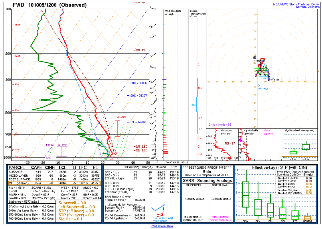
Does this qualify as a multilayered cap?
1 likes
The above post and any post by dhweather is NOT an official forecast and should not be used as such. It is just the opinion of the poster and may or may not be backed by sound meteorological data. It is NOT endorsed by any professional institution including storm2k.org. For official information, please refer to NWS products.
- Haris
- Category 5

- Posts: 1814
- Joined: Mon Nov 27, 2017 8:19 pm
- Location: ( Bee Cave) West Austin, Texas
Re: Texas Fall 2018
Afternoon European has 3,000 - 4,000 cape over SCTX Tuesday....
Shows a very impressive likely squall line from Oklahoma- Dallas - Austin
2” for Austin! Yes please
Shows a very impressive likely squall line from Oklahoma- Dallas - Austin
2” for Austin! Yes please
1 likes
Weather geek and a storm spotter in West Austin. Not a degreed meteorologist. Big snow fan. Love rain and cold! Despise heat!
-
weatherdude1108
- Category 5

- Posts: 4228
- Joined: Tue Dec 13, 2011 1:04 pm
- Location: Northwest Austin/Cedar Park, TX
Re: Texas Fall 2018
0 likes
The preceding post is NOT an official forecast, and should not be used as such. It is only the opinion of the poster and may or may not be backed by sound meteorological data. It is NOT endorsed by any professional institution including storm2k.org. For Official Information please refer to the NHC and NWS products.
-
weatherdude1108
- Category 5

- Posts: 4228
- Joined: Tue Dec 13, 2011 1:04 pm
- Location: Northwest Austin/Cedar Park, TX
Re: Texas Fall 2018
EWX:
000
FXUS64 KEWX 052014
AFDEWX
Area Forecast Discussion
National Weather Service Austin/San Antonio TX
314 PM CDT Fri Oct 5 2018
.SHORT TERM (Tonight through Saturday Night)...
A few light showers are ongoing across portions of the coastal plains
early this afternoon. Radar trends along with most of the hi-res
model guidance suggest most activity will remain east of the
I-35/I-37 corridors this afternoon. With this in mind, we did reduce
rain chances slightly along the I-35 corridor for the remainder of
today. Most areas should remain dry this evening, but as the low-
level jet strengthens, we do expect a few showers will develop
during the early morning hours on Saturday. For Saturday afternoon,
rain chances will be favored along and east of the I-35 corridor as
moisture levels will be higher across the mentioned region. With the
subtropical ridge axis to our east loosing some strength, we could
see a little increase in coverage of showers and storms for Saturday
afternoon compared to the last couple of days.
&&
.LONG TERM (Sunday through Friday)...
On Sunday, a lead shortwave trough axis will approach from the west.
This should help to weaken the upper ridge to our east and begin to
allow for a little more active southwest flow aloft to the region.
Rain chances will increase slightly on Sunday with scattered showers
and storms expected, especially during the afternoon hours. Rain
chances are then to set to increase Monday and Tuesday as the main
upper trough axis moves in from the west. We also continue to monitor
for tropical development in the Gulf during the middle of the
upcoming week. As of now, it appears any tropical activity that
develops in the Gulf should remain east of our region.
Rain chances will decrease quickly on Wednesday and Thursday as the
upper trough axis moves east of the region. Much drier air behind
the upper trough axis will move in and bring dry weather to our area.
For late next week, the medium range models show good agreement in
bringing the remnants of Hurricane Sergio into the desert southwest
or southern Rockies by early Friday morning. For now, we will only
mention a chance of rain across portions of the southern Edwards
Plateau and Rio Grande plains and leave the remainder of the region
dry.
&&
0 likes
The preceding post is NOT an official forecast, and should not be used as such. It is only the opinion of the poster and may or may not be backed by sound meteorological data. It is NOT endorsed by any professional institution including storm2k.org. For Official Information please refer to the NHC and NWS products.
-
weatherdude1108
- Category 5

- Posts: 4228
- Joined: Tue Dec 13, 2011 1:04 pm
- Location: Northwest Austin/Cedar Park, TX
Re: Texas Fall 2018
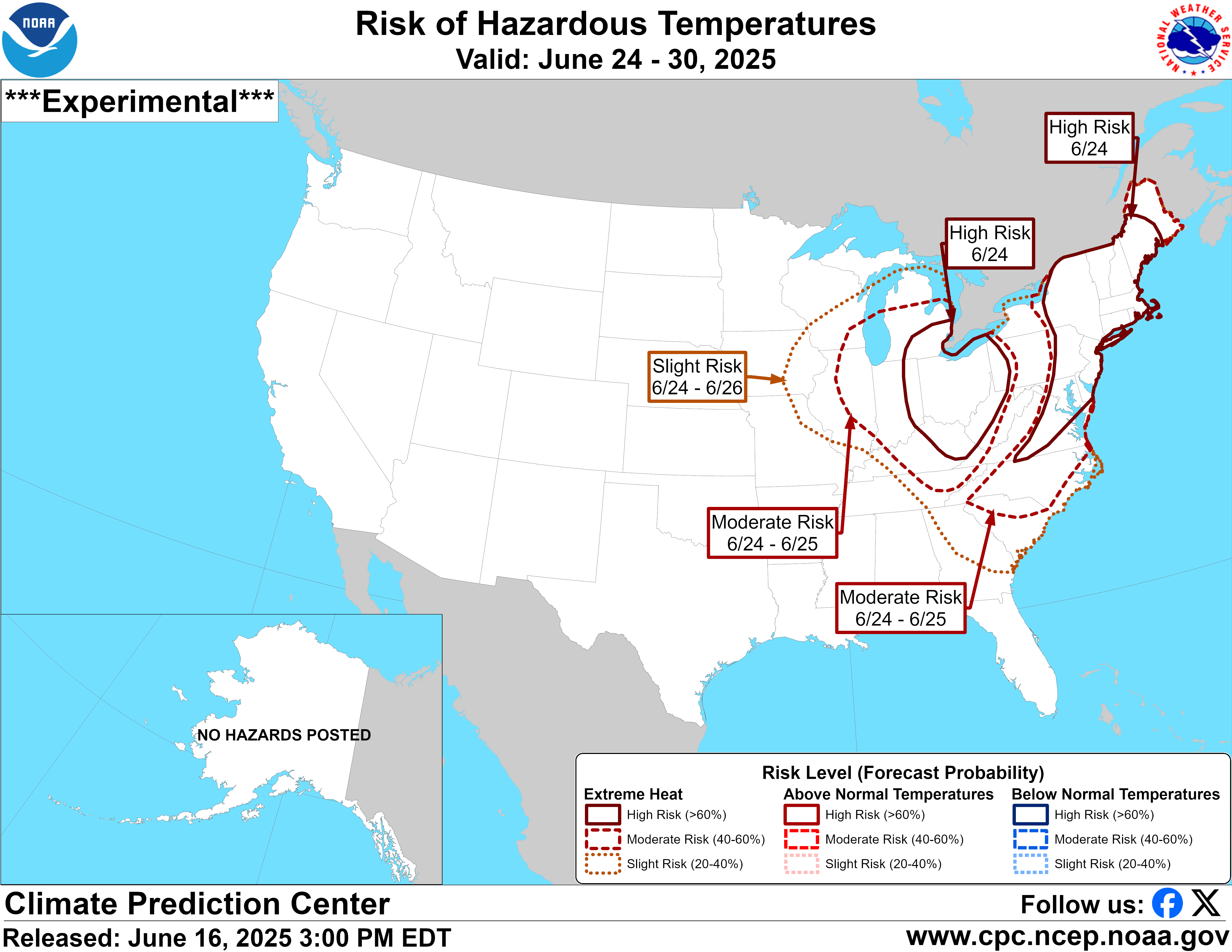
Interesting about the slight risk of hazardous temperatures, as far down as south central Texas.


2 likes
The preceding post is NOT an official forecast, and should not be used as such. It is only the opinion of the poster and may or may not be backed by sound meteorological data. It is NOT endorsed by any professional institution including storm2k.org. For Official Information please refer to the NHC and NWS products.
-
Brent
- S2K Supporter

- Posts: 38740
- Age: 37
- Joined: Sun May 16, 2004 10:30 pm
- Location: Tulsa Oklahoma
- Contact:
Re: Texas Fall 2018
still 60s for highs next weekend forecast on TV
Could it actually verify this time?
Could it actually verify this time?
1 likes
#neversummer
Re: Texas Fall 2018
Brent wrote:still 60s for highs next weekend forecast on TV
Could it actually verify this time?
Just saw that. In one week we could be tracking the arrival of a bona fide fall front. Oh please, oh please, oh please.
1 likes
- starsfan65
- Category 2

- Posts: 738
- Age: 48
- Joined: Thu Dec 17, 2015 1:18 pm
- Location: Garland,Tx
Re: Texas Fall 2018
Brent wrote:still 60s for highs next weekend forecast on TV
Could it actually verify this time?
Channel 8 doesn't show that
0 likes
-
Brent
- S2K Supporter

- Posts: 38740
- Age: 37
- Joined: Sun May 16, 2004 10:30 pm
- Location: Tulsa Oklahoma
- Contact:
Re: Texas Fall 2018
starsfan65 wrote:Brent wrote:still 60s for highs next weekend forecast on TV
Could it actually verify this time?
Channel 8 doesn't show that
Channel 5 had it
end of the 18z GFS has a snowstorm for the Panhandle

1 likes
#neversummer
Re: Texas Fall 2018
Hey, sorry I've been MIA lately, things have been hectic in my life but looks like its starting to settle down so expect to see me around more often. Got just a little over 6 inches for September and about an inch to start off October. Looking forward to seeing how the rest of this month pans out for rainfall.
4 likes
Resident Rain Miser
I am a weather hobbyist living 3.5 miles south of Downtown Austin and in no way or fashion should anything I say concerning forecasts be taken seriously. Please check your local NWS for accurate weather forecasting and conditions.
I am a weather hobbyist living 3.5 miles south of Downtown Austin and in no way or fashion should anything I say concerning forecasts be taken seriously. Please check your local NWS for accurate weather forecasting and conditions.
-
Brent
- S2K Supporter

- Posts: 38740
- Age: 37
- Joined: Sun May 16, 2004 10:30 pm
- Location: Tulsa Oklahoma
- Contact:
Re: Texas Fall 2018
GFS has multiple days where Dallas would struggle to 70 for a high starting next weekend
The heat and humidity days are numbered...
The heat and humidity days are numbered...
1 likes
#neversummer
-
DFW Stormwatcher
- Tropical Storm

- Posts: 243
- Age: 55
- Joined: Sun Dec 27, 2009 10:35 pm
- Location: Keller, Tx
Re: Texas Fall 2018
starsfan65 wrote:Brent wrote:still 60s for highs next weekend forecast on TV
Could it actually verify this time?
Channel 8 doesn't show that
Channel 8 hasn't had a real meteorologists since Steve McCauley left, Channel 5 has several weathermen hat are more on point. No station gets all of the weather chasing tools channel 5 has without some true dorks on board:) They're the only ones with a mobile doppler truck and a storm truck in North Texas.
1 likes
Disclaimer: This is not an official weather forecast. I am only an amateur weather enthusiast therefore any weather forecasts or opinions should be taken with a grain of salt. Hook em Horns!
-
DFW Stormwatcher
- Tropical Storm

- Posts: 243
- Age: 55
- Joined: Sun Dec 27, 2009 10:35 pm
- Location: Keller, Tx
Re: Texas Fall 2018
DFW Stormwatcher wrote:starsfan65 wrote:Brent wrote:still 60s for highs next weekend forecast on TV
Could it actually verify this time?
Channel 8 doesn't show that
Channel 8 hasn't had a real meteorologist since Steve McCauley left, Channel 5 has several weathermen hat are more on point. No station gets all of the weather chasing tools channel 5 has without some true dorks on board:) They're the only ones with a mobile doppler truck and a storm truck in North Texas.
0 likes
Disclaimer: This is not an official weather forecast. I am only an amateur weather enthusiast therefore any weather forecasts or opinions should be taken with a grain of salt. Hook em Horns!
-
DFW Stormwatcher
- Tropical Storm

- Posts: 243
- Age: 55
- Joined: Sun Dec 27, 2009 10:35 pm
- Location: Keller, Tx
Re: Texas Fall 2018
DFW Stormwatcher wrote:DFW Stormwatcher wrote:starsfan65 wrote:Channel 8 doesn't show that
Channel 8 hasn't had a real meteorologist since Steve McCauley left, Channel 5 has several weathermen that are more on point. No station gets all of the weather chasing tools channel 5 has without some true dorks on board:) They're the only ones with a mobile doppler truck and a storm truck in North Texas.
0 likes
Disclaimer: This is not an official weather forecast. I am only an amateur weather enthusiast therefore any weather forecasts or opinions should be taken with a grain of salt. Hook em Horns!
- Haris
- Category 5

- Posts: 1814
- Joined: Mon Nov 27, 2017 8:19 pm
- Location: ( Bee Cave) West Austin, Texas
Re: Texas Fall 2018
Gotta a very heavy storm out in W Austin this morning.
A quick .64" fell @ my location.

A quick .64" fell @ my location.
4 likes
Weather geek and a storm spotter in West Austin. Not a degreed meteorologist. Big snow fan. Love rain and cold! Despise heat!
Re: Texas Fall 2018
Who is ready for the first real strong TX cold front? As much as I dislike cold weather.............unless it snows.......the first strong cold front is always refreshing and finishes off any late season NW GOM tropical threats for the season.
2 likes
The following post is NOT an official forecast and should not be used as such. It is just the opinion of the poster and may or may not be backed by sound meteorological data. It is NOT endorsed by any professional institution including storm2k.org For Official Information please refer to the NHC and NWS products.
- Haris
- Category 5

- Posts: 1814
- Joined: Mon Nov 27, 2017 8:19 pm
- Location: ( Bee Cave) West Austin, Texas
Re: Texas Fall 2018
12z GFS has Sergio recurving into TX and I mean.... a deluge beyond 


3 likes
Weather geek and a storm spotter in West Austin. Not a degreed meteorologist. Big snow fan. Love rain and cold! Despise heat!
Re: Texas Fall 2018
Haris wrote:12z GFS has Sergio recurving into TX and I mean.... a deluge beyond

I just saw this. Caught me by surprise no doubt. Idk what to think of it though. It kinda came outta nowhere to me lol
0 likes
Return to “USA & Caribbean Weather”
Who is online
Users browsing this forum: TomballEd and 66 guests


