
ATL: MICHAEL - Models
Moderator: S2k Moderators
-
ColdMiser123

- Professional-Met

- Posts: 905
- Age: 29
- Joined: Mon Sep 26, 2016 3:26 pm
- Location: Northeast US
Re: ATL: MICHAEL - Models
Most of the eastern tracks are slower, and thus are stronger, having more time over water. This is a result of the shifting upper level steering pattern with a weakening ridge to the northeast of Michael.
3 likes
B.S., M.S., Meteorology & Atmospheric Science
Re: ATL: MICHAEL - Models
ColdMiser123 wrote:Most of the eastern tracks are slower, and thus are stronger, having more time over water. This is a result of the shifting upper level steering pattern with a weakening ridge to the northeast of Michael.
https://i.imgur.com/WkiLEX7.png
If you were to extend out through day 10, you'd see the mean track through day 10 is shifted further SE.
0 likes
Personal Forecast Disclaimer:
The posts in this forum are NOT official forecasts and should not be used as such. They are just the opinion of the poster and may or may not be backed by sound meteorological data. They are NOT endorsed by any professional institution or storm2k.org. For official information, please refer to the NHC and NWS products.
The posts in this forum are NOT official forecasts and should not be used as such. They are just the opinion of the poster and may or may not be backed by sound meteorological data. They are NOT endorsed by any professional institution or storm2k.org. For official information, please refer to the NHC and NWS products.

Re: ATL: MICHAEL - Models
18Z Early Models.
If what recon is finding is legit, shift everything east a bit.

If what recon is finding is legit, shift everything east a bit.
0 likes
-
gatorcane

- S2K Supporter

- Posts: 23708
- Age: 48
- Joined: Sun Mar 13, 2005 3:54 pm
- Location: Boca Raton, FL
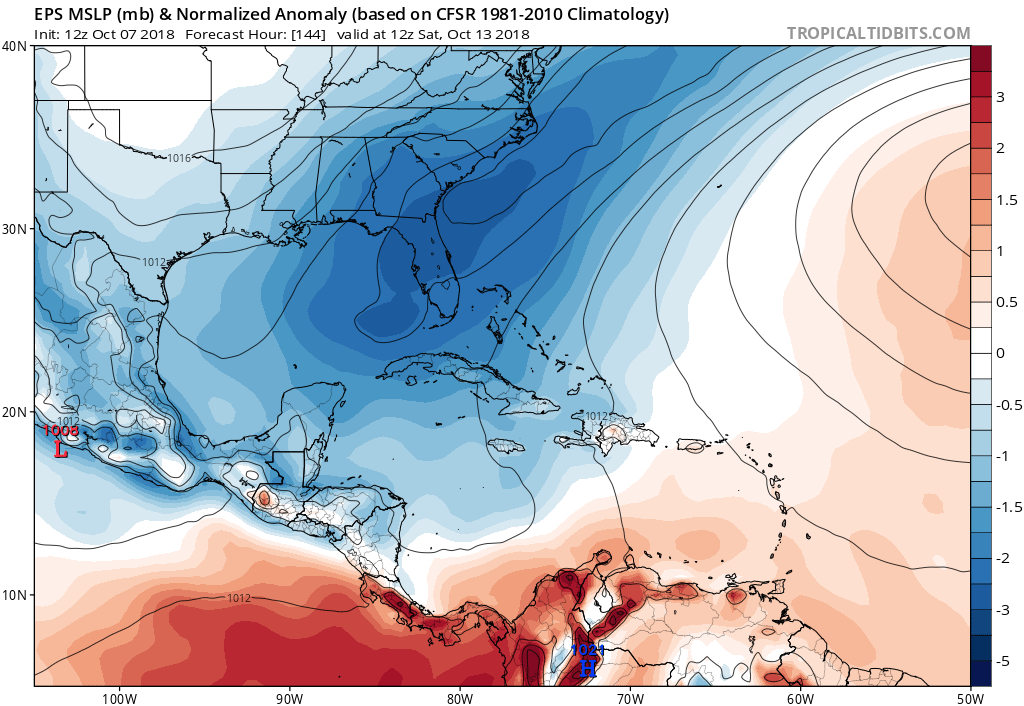
Re: ATL: MICHAEL - Models
12Z Euro ensembles with some members in the Eastern Gulf and down into Central Florida till 6 days from now:
0 likes

Re: ATL: MICHAEL - Models
gatorcane wrote:12Z Euro ensembles with some members in the Eastern Gulf and down into Central Florida till 6 days from now:
https://i.postimg.cc/1zccg3pf/ecmwf-ens_mslpa_Norm_watl_7.png
0 likes
Just then the wind came squalling through the door,
But who can the weather command?
But who can the weather command?
-
gatorcane
- S2K Supporter
- Posts: 23708
- Age: 48
- Joined: Sun Mar 13, 2005 3:54 pm
- Location: Boca Raton, FL
Re: ATL: MICHAEL - Models
Wow a number of Euro ensembles take this north of Tampa now on an ENE track with two landfalling just north of the Tampa area. A strong system would cause some problems for Tampa with the onshore flow even if landfall was Cedar Key.
Last edited by gatorcane on Sun Oct 07, 2018 3:26 pm, edited 1 time in total.
0 likes

Re: ATL: MICHAEL - Models
Not sure if it was mentioned that the 18z SHIPS now calls for Michael to be at 80 knots at landfall, up 30 knots from just 24 hrs ago so who is not to think that it will continue to go up on its intensity forecast.

0 likes
Re: ATL: MICHAEL - Models
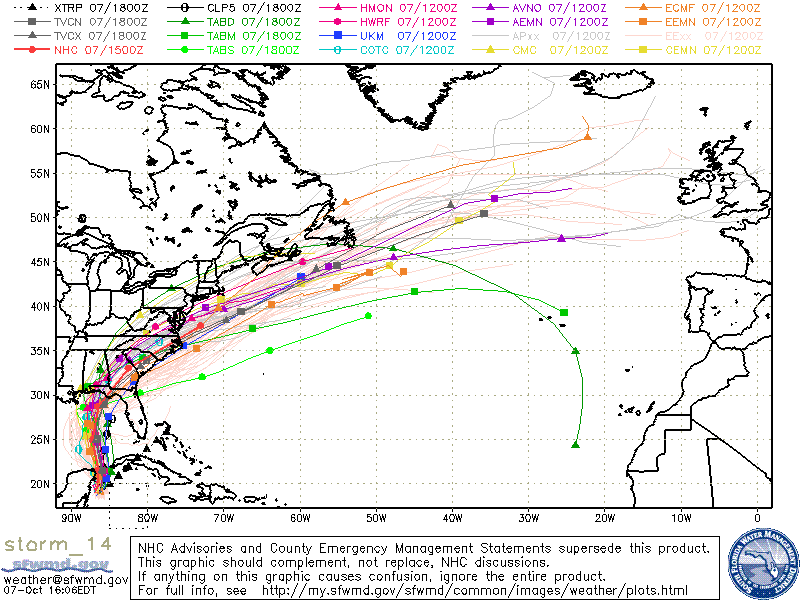
One striking thing about the Euro ensembles, look how many show major hurricane, and how east heavy those majors are:

1 likes

-
OuterBanker
- S2K Supporter
- Posts: 1761
- Joined: Wed Feb 26, 2003 10:53 am
- Location: Nags Head, NC
- Contact:
Re: ATL: MICHAEL - Models
BobHarlem wrote:One striking thing about the Euro ensembles, look how many show major hurricane, and how east heavy those majors are:
https://i.imgur.com/TEyF2HF.jpg
Wow, been busy and away from here all day. Last night I thought Michael would ride the mountains. This Euro ensemble looks like a coast rider after hitting the panhandle. This looks like potential trouble for Fl. GA. SC. and NC. Of course that's only one run.
0 likes

Re: ATL: MICHAEL - Models
BobHarlem wrote:One striking thing about the Euro ensembles, look how many show major hurricane, and how east heavy those majors are:
https://i.imgur.com/TEyF2HF.jpg
I was looking at that. The stronger system which this one looks like it will be is on the eastern side.
0 likes
The following post is NOT an official forecast and should not be used as such. It is just the opinion of the poster and may or may not be backed by sound meteorological data. It is NOT endorsed by any professional institution including storm2k.org For Official Information please refer to the NHC and NWS products.

Re: ATL: MICHAEL - Models
0 likes
-
DestinHurricane

- Category 4

- Posts: 935
- Joined: Tue May 01, 2018 8:05 am
- Location: New York, NY
Re: ATL: MICHAEL - Models
DestinHurricane wrote:18Z GFS a tad NW and stronger at 36 hours
At hour 30, the 18Z GFS is at 22.5N, 86.4W vs the 12Z GFS 36 hour of 23.1N, 86.1W. So, the 18Z GFS so far is SSW of the 12Z GFS position.
Edit hour 48 nearly identical to the 12Z.
0 likes
Personal Forecast Disclaimer:
The posts in this forum are NOT official forecasts and should not be used as such. They are just the opinion of the poster and may or may not be backed by sound meteorological data. They are NOT endorsed by any professional institution or storm2k.org. For official information, please refer to the NHC and NWS products.
The posts in this forum are NOT official forecasts and should not be used as such. They are just the opinion of the poster and may or may not be backed by sound meteorological data. They are NOT endorsed by any professional institution or storm2k.org. For official information, please refer to the NHC and NWS products.

Re: ATL: MICHAEL - Models
LarryWx wrote:DestinHurricane wrote:18Z GFS a tad NW and stronger at 36 hours
At hour 30, the 18Z GFS is at 22.5N, 86.4W vs the 12Z GFS 36 hour of 23.1N, 86.1W. So, the 18Z GFS so far is SSW of the 12Z GFS position.
Was this run initialized at the new center location?
0 likes

Re: ATL: MICHAEL - Models
Really bizarre to see a full 24 hr difference in landfall between the GFS and ECM just 72 hrs out. Not sure Ive seen anything that large between our two major models before.
0 likes
Re: ATL: MICHAEL - Models
Interesting part about the 18z GFS run is that it was started further west based on the old LLC.
0 likes
Re: ATL: MICHAEL - Models
pgoss11 wrote:LarryWx wrote:DestinHurricane wrote:18Z GFS a tad NW and stronger at 36 hours
At hour 30, the 18Z GFS is at 22.5N, 86.4W vs the 12Z GFS 36 hour of 23.1N, 86.1W. So, the 18Z GFS so far is SSW of the 12Z GFS position.
Was this run initialized at the new center location?
Kind of between them at 18.9N, 85.8W.
Edit: Then it moves NNW to 19.7N, 86.1W at hour 6 or 8 PM EDT this evening. The actual 8 PM position would be very nice to know!
Last edited by LarryWx on Sun Oct 07, 2018 4:51 pm, edited 3 times in total.
0 likes
Personal Forecast Disclaimer:
The posts in this forum are NOT official forecasts and should not be used as such. They are just the opinion of the poster and may or may not be backed by sound meteorological data. They are NOT endorsed by any professional institution or storm2k.org. For official information, please refer to the NHC and NWS products.
The posts in this forum are NOT official forecasts and should not be used as such. They are just the opinion of the poster and may or may not be backed by sound meteorological data. They are NOT endorsed by any professional institution or storm2k.org. For official information, please refer to the NHC and NWS products.
-
cycloneye

- Admin

- Posts: 149167
- Age: 69
- Joined: Thu Oct 10, 2002 10:54 am
- Location: San Juan, Puerto Rico
Re: ATL: MICHAEL - Models
NDG wrote:Interesting part about the 18z GFS run is that it was started further west based on the old LLC.
On the other hand,it began at 999 mbs and that was the pressure of the second LLC.
0 likes
Visit the Caribbean-Central America Weather Thread where you can find at first post web cams,radars
and observations from Caribbean basin members Click Here
and observations from Caribbean basin members Click Here
Re: ATL: MICHAEL - Models
NDG wrote:Interesting part about the 18z GFS run is that it was started further west based on the old LLC.
That is an important point to consider as the run comes out.
May have to discount it.
0 likes
Who is online
Users browsing this forum: No registered users and 9 guests