ATL: MICHAEL - Post-Tropical - Discussion
Moderator: S2k Moderators
-
SFLcane

- S2K Supporter

- Posts: 10281
- Age: 48
- Joined: Sat Jun 05, 2010 1:44 pm
- Location: Lake Worth Florida
Re: ATL: MICHAEL - Hurricane - Discussion
I'am with GBPackMan here by no means the gulf looks ideal for RI. Inhibiting factors such as strong winds aloft from the west, along with dry air ingestion, are going to likely keep the system tilted with height. I just don't see a prime setup where you should seek explosive development.
0 likes
-
tolakram
- Admin

- Posts: 20186
- Age: 62
- Joined: Sun Aug 27, 2006 8:23 pm
- Location: Florence, KY (name is Mark)
Re: ATL: MICHAEL - Hurricane - Discussion
xironman wrote:GBPackMan wrote: Add in the fall temperatures over land in the southeastern US dipping into the 60s at night getting drawn into the storm.
I took a look at Columbus GA http://www.nws.noaa.gov/cgi-bin/mos/getmav.pl?sta=KCSG and it is still pretty warm an humid. Low Wednesday around 75 and dews close to 70.
We've only gotten down to the upper 60's up here in Cincinnati as well. It's mid summer weather in October.
2 likes
M a r k
- - - - -
Join us in chat: Storm2K Chatroom Invite. Android and IOS apps also available.
The posts in this forum are NOT official forecasts and should not be used as such. Posts are NOT endorsed by any professional institution or STORM2K.org. For official information and forecasts, please refer to NHC and NWS products.

Re: Common sense for Panhandle folks and others
Salute!
TNX, Gulf and Blow. Good to hear from locals who have prolly been thru a few of these things.
Vet of Erin (tree thru roof), Opal (crushed a car and a dozen trees down that missed house and truck), Dennis, and many others since 1985.
One must evaluate the risks before doing anything rash. I see many folks thinking that all of the coast will look like Waveland, MS after Katrina or Holly Beach in Louisiana after Rita: see:
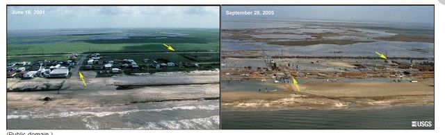
or, https://www.usgs.gov/media/images/and-a ... -louisiana
And that's the reason for number one on your evaluation:
Is your abode directly on the coast AND less than 25 or 30 feet MSL?
Unless the storm is very weak AND to your east, but instead is to your west, then get outta dodge and come back later. Here in the Panhandle until eastern Bay and those counties further east, we have the highest coastline in the state. At many places, within 200 feet we're above 25 feet or higher!!!! Where the "Truman Show" was filmed is a good example ( Seaside). So many surges are not a problem for us, but the wind. Those below 15 or 20 feet MSL have a problem, as the waves will ride on top of the 10 foot surge. I have a friend in Pass Christian, MS at 18 or 20 feet counting his pilings, and his Katrina water got to the ceiling on his living level. He was a mile from the coast and had good trees, so no waves beating on him. Others a half mile inland at Waveland were gone except for pipes sticking outta the slabs.
What kinda trees do you have and how are they situated? The long leaf pines and spanish oaks do not live to be 200 or 250 years old if they are wimps and blow down in one of the storms they will see in their lifetime. Short leaf pines and laurel oaks will go down easily, especially if you have lottsa rain ahead of landfall and during the storm. We learned the hard way in Erin and Opal. So boarding up a bit might prevent windblown debris damage, but not that 60 foot shortleaf pine that comes thru the roof.
So last thing from the short list is to evaluate how reliable is your electricity/gas/water and what you can do? We cooked just fine after several storms and took hot showers due to our gas utilities. Doesn't hurt to clean and fill a bathtub in case there's a break or contamination in normal supply. Generators are neat for very short times, like a day or so unless you have a 100 gallon tank in your yard or have it run by natural gas. On the day after you will see folks siphoning gasoline and using their boat gas and so on. Be ready to go without electricity for three or more days in any case. Freezer food will keep for days unless you keep peeking inside the door. Microwave dinners are not good, duh???? A good BBQ and full propane tank(s) is essential. Coleman gear is also great.
Finally, do not count on your cell phone!!!! Have a cheap landline contract and a cheap old phone. Even with a good phone line your walkaround doofers will not work 'cause the base station isn't powered.. As I drove 200 miles to rescue my 85 year old parents just north of New Orleans after Katrina, and I passed dozens of cell towers but no comm possible. OTOH, I talked with Dad as the eye passed overhead and trees had fallen and still falling. That ohone worked with lines laying in the street until some jackass cut it with his bobcat.
;nuf philosophy, as we're filling gas tanks and stocking the pantry.
Gums sends...
TNX, Gulf and Blow. Good to hear from locals who have prolly been thru a few of these things.
Vet of Erin (tree thru roof), Opal (crushed a car and a dozen trees down that missed house and truck), Dennis, and many others since 1985.
One must evaluate the risks before doing anything rash. I see many folks thinking that all of the coast will look like Waveland, MS after Katrina or Holly Beach in Louisiana after Rita: see:
or, https://www.usgs.gov/media/images/and-a ... -louisiana
And that's the reason for number one on your evaluation:
Is your abode directly on the coast AND less than 25 or 30 feet MSL?
Unless the storm is very weak AND to your east, but instead is to your west, then get outta dodge and come back later. Here in the Panhandle until eastern Bay and those counties further east, we have the highest coastline in the state. At many places, within 200 feet we're above 25 feet or higher!!!! Where the "Truman Show" was filmed is a good example ( Seaside). So many surges are not a problem for us, but the wind. Those below 15 or 20 feet MSL have a problem, as the waves will ride on top of the 10 foot surge. I have a friend in Pass Christian, MS at 18 or 20 feet counting his pilings, and his Katrina water got to the ceiling on his living level. He was a mile from the coast and had good trees, so no waves beating on him. Others a half mile inland at Waveland were gone except for pipes sticking outta the slabs.
What kinda trees do you have and how are they situated? The long leaf pines and spanish oaks do not live to be 200 or 250 years old if they are wimps and blow down in one of the storms they will see in their lifetime. Short leaf pines and laurel oaks will go down easily, especially if you have lottsa rain ahead of landfall and during the storm. We learned the hard way in Erin and Opal. So boarding up a bit might prevent windblown debris damage, but not that 60 foot shortleaf pine that comes thru the roof.
So last thing from the short list is to evaluate how reliable is your electricity/gas/water and what you can do? We cooked just fine after several storms and took hot showers due to our gas utilities. Doesn't hurt to clean and fill a bathtub in case there's a break or contamination in normal supply. Generators are neat for very short times, like a day or so unless you have a 100 gallon tank in your yard or have it run by natural gas. On the day after you will see folks siphoning gasoline and using their boat gas and so on. Be ready to go without electricity for three or more days in any case. Freezer food will keep for days unless you keep peeking inside the door. Microwave dinners are not good, duh???? A good BBQ and full propane tank(s) is essential. Coleman gear is also great.
Finally, do not count on your cell phone!!!! Have a cheap landline contract and a cheap old phone. Even with a good phone line your walkaround doofers will not work 'cause the base station isn't powered.. As I drove 200 miles to rescue my 85 year old parents just north of New Orleans after Katrina, and I passed dozens of cell towers but no comm possible. OTOH, I talked with Dad as the eye passed overhead and trees had fallen and still falling. That ohone worked with lines laying in the street until some jackass cut it with his bobcat.
;nuf philosophy, as we're filling gas tanks and stocking the pantry.
Gums sends...
Last edited by Gums on Mon Oct 08, 2018 2:31 pm, edited 1 time in total.
7 likes

Re: ATL: MICHAEL - Hurricane - Discussion
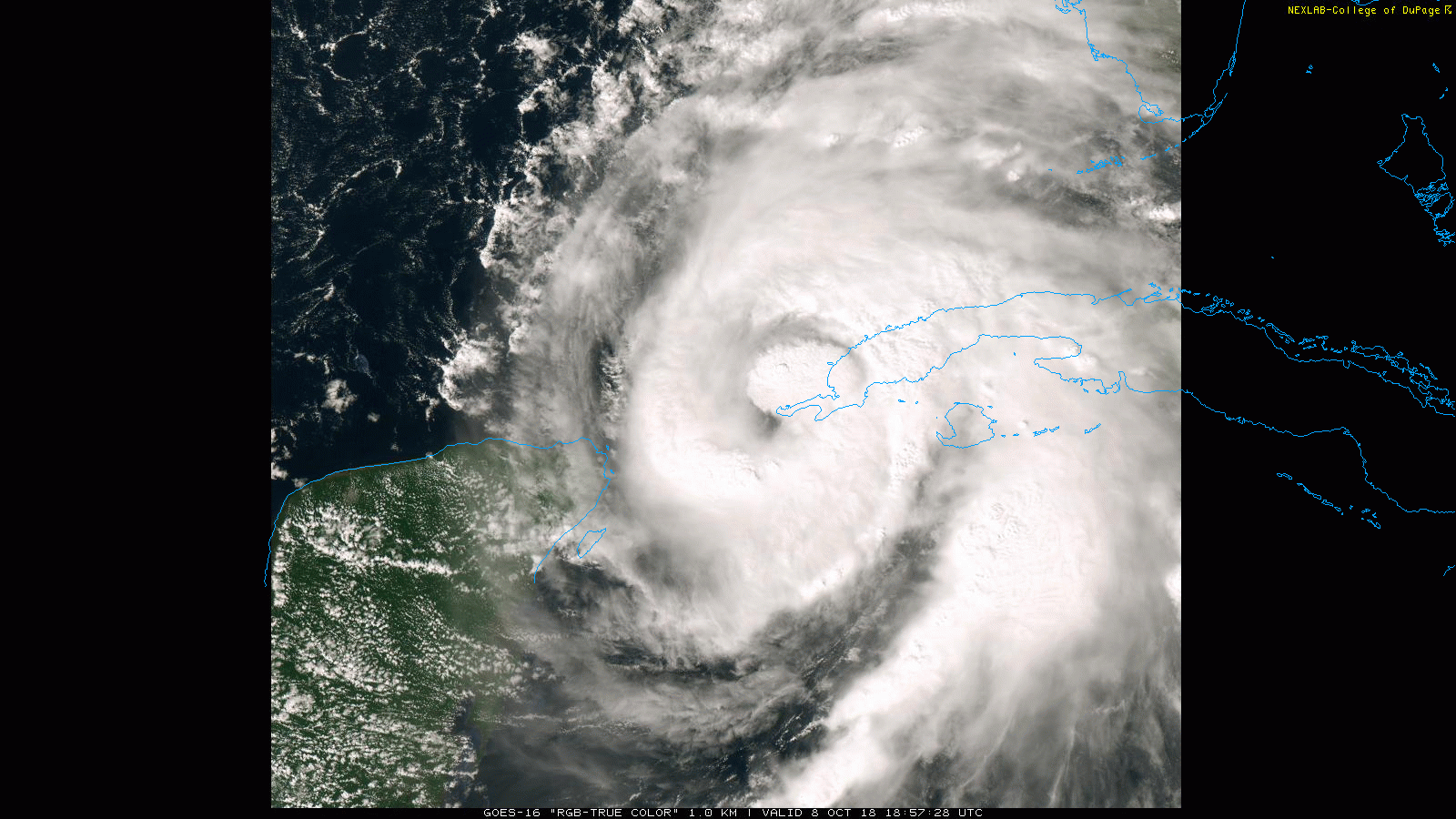
What is really worrying me is the fact that Michael is already down to 978mb and producing 80kt fl winds with a still flabby core...
That is a bit of a warning sign to me...what happens if the core does tighten up?
That is a bit of a warning sign to me...what happens if the core does tighten up?
1 likes
Personal Forecast Disclaimer:
The posts in this forum are NOT official forecast and should not be used as such. They are just the opinion of the poster and may or may not be backed by sound meteorological data. They are NOT endorsed by any professional institution or storm2k.org. For official information, please refer to the NHC and NWS products
The posts in this forum are NOT official forecast and should not be used as such. They are just the opinion of the poster and may or may not be backed by sound meteorological data. They are NOT endorsed by any professional institution or storm2k.org. For official information, please refer to the NHC and NWS products

Re: ATL: MICHAEL - Hurricane - Discussion
Some explosive convection rotating around to the north, looks like it's trying to mix out the dry air.
1 likes
The above post is not official and should not be used as such. It is the opinion of the poster and may or may not be backed by sound meteorological data. It is not endorsed by any professional institution or storm2k.org. For official information, please refer to the NHC and NWS products.
Re: ATL: MICHAEL - Hurricane - Discussion
SFLcane wrote:I'am with GBPackMan here by no means the gulf looks ideal for RI. Inhibiting factors such as strong winds aloft from the west, along with dry air ingestion, are going to likely keep the system tilted with height. I just don't see a prime setup where you should seek explosive development.
It does not look super dry

2 likes
-
GBPackMan
Re: ATL: MICHAEL - Hurricane - Discussion
artist wrote:GBPackMan wrote:tolakram wrote:
I don't mind you giving an opinion, but can you really back up this statement? HWRF is one of the few models to show consistent intensity skill at 3 days. The NHC goes over these stats every year, you can find them on their web page.
That's 110kts at landfall. Can you identify the other models you used?
https://imgur.com/ENW4YVt
Some models do well at path, not so much at directional speed or intensity, some do well with intensity but not so much the path or speed, etc. HWRF is one that has done well with intensity, but not so well with path or movement speed. This is where GFS and the Euro model have fared better the last few years.
So looking at the models that have a fairly consistent past accuracy with intensity, points to a high likelihood of a strong Cat 1 being the most likely scenario, with possible bump into Cat 2 before dropping off 12-18h before landfall. Almost all of them show the intensity either leveling or dropping off from 36-48h (from 12z Oct 8 model runs). The 18z should be coming out soon so this may change.
Still, with the cooler night time autumn air over the southeastern US, plus the cooler outflow from the jet stream with the southern point slowly adjusting NNE getting drawn into the storm around 24h before landfall, this points to a decent weakening. This is why I believe a weak Cat 2, then approx 24h before landfall the cooler drier air being drawn in weakening it to 80-90mph max winds within a narrow area of the eye.
I personally think you might be forgetting the storm surge effect.
Most of the panhandle is sandy ground with fairly heavy pine tree forests and plenty of uninhabited swamp areas which is natures way of handling water overflow. We can get 2-4" of rain within 1-2 hours and things could be dry 2 hours later. This sand is able to handle this amount of water much better than the clay or dirt soils further inland.
Where the coastal areas will see some storm surge, this threat is primarily along the coastal areas, inland is a much lower impact aside from flash flooding in low lying areas that tend to flood anyways during a heavy summer thunderstorm.
From Tallahassee area to the coast is actually quite an elevation increase (essentially is Appalachian foothills), but the Apalachicola area is low lying and very swampy so much more prone to storm surge effects. The Apalachee Bay coastal area (area south of Tallahassee) is primarily uninhabited state/federal lands, so what is not foot hills, is uninhabited swamp land.
2 likes
-
supercane4867
- Category 5

- Posts: 4966
- Joined: Wed Nov 14, 2012 10:43 am
-
GBPackMan
Re: ATL: MICHAEL - Hurricane - Discussion
xironman wrote:SFLcane wrote:I'am with GBPackMan here by no means the gulf looks ideal for RI. Inhibiting factors such as strong winds aloft from the west, along with dry air ingestion, are going to likely keep the system tilted with height. I just don't see a prime setup where you should seek explosive development.
It does not look super dry
https://i.imgur.com/5ayMAfV.png
That model was reliant on the southern end of the jet stream moving NNE from western TX, which has not yet happened. That means additional inflow of drier air will likely be seen with the better 18z models, which in turn means a slight decrease in intensity models.
0 likes
-
AutoPenalti
- Category 5
- Posts: 4091
- Age: 29
- Joined: Mon Aug 17, 2015 4:16 pm
- Location: Ft. Lauderdale, Florida
Re: ATL: MICHAEL - Hurricane - Discussion
That’s one hell of a gravity wave.
2 likes
The posts in this forum are NOT official forecasts and should not be used as such. They are just the opinion of the poster and may or may not be backed by sound meteorological data. They are NOT endorsed by any professional institution or STORM2K. For official information, please refer to products from the NHC and NWS.
Model Runs Cheat Sheet:
GFS (5:30 AM/PM, 11:30 AM/PM)
HWRF, GFDL, UKMET, NAVGEM (6:30-8:00 AM/PM, 12:30-2:00 AM/PM)
ECMWF (1:45 AM/PM)
TCVN is a weighted averaged
-
ScottNAtlanta

- Category 5
- Posts: 2535
- Joined: Sat May 25, 2013 3:11 pm
- Location: Atlanta, GA
Re: ATL: MICHAEL - Hurricane - Discussion
SFLcane wrote:I'am with GBPackMan here by no means the gulf looks ideal for RI. Inhibiting factors such as strong winds aloft from the west, along with dry air ingestion, are going to likely keep the system tilted with height. I just don't see a prime setup where you should seek explosive development.
I see absolutely no sign of westward shear or midlevel shear on satellite right now

2 likes
The posts in this forum are NOT official forecast and should not be used as such. They are just the opinion of the poster and may or may not be backed by sound meteorological data. They are NOT endorsed by any professional institution or storm2k.org. For official information, please refer to the NHC and NWS products.
-
wxman57

- Moderator-Pro Met

- Posts: 23175
- Age: 68
- Joined: Sat Jun 21, 2003 8:06 pm
- Location: Houston, TX (southwest)
Re: ATL: MICHAEL - Hurricane - Discussion
chaser1 wrote:
The difference is amazing between max (Cat 3) surge near Panama City vs. Apalachca Bay. Didn't realize there'd be that much of a difference. In addition to the shallower waters further east, I suppose there's also the fact that a greater forcing of water "pile-up" would exist to the east, whereas further west along the Panhandle the increased storm surge can at least spread out a greater distance perpendicular to the coastline?
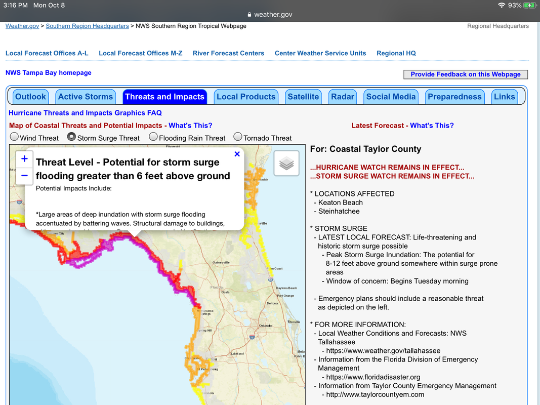
One key factor in storm surge calculations is called the "Shoaling Factor". The shoaling factor relates to the distance offshore to the 10-fathom depth (60 ft). The closer to the coast that 10-fathom depth, the less the storm surge threat. Note that for Pensacola to Panama City, the multiplier in the storm surge calculation is only about 0.4. Compare that to 1.8 in Vermilion Bay or 1.75 on the Mississippi Coast (or the 1.1 to 1.2 in Apalachee Bay). The shoaling factor is one of the more significant factors in storm surge height.
Here's a graphic I made from a similar chart in my old (very old) Mariner's Shore Protection Manual. The calculation methods in that manual still work well today.

5 likes

-
cycloneye

- Admin
- Posts: 149719
- Age: 69
- Joined: Thu Oct 10, 2002 10:54 am
- Location: San Juan, Puerto Rico
Re: ATL: MICHAEL - Hurricane - Discussion
3 likes
Visit the Caribbean-Central America Weather Thread where you can find at first post web cams,radars
and observations from Caribbean basin members Click Here
and observations from Caribbean basin members Click Here
Re: ATL: MICHAEL - Hurricane - Discussion
GBPackMan wrote:xironman wrote:SFLcane wrote:I'am with GBPackMan here by no means the gulf looks ideal for RI. Inhibiting factors such as strong winds aloft from the west, along with dry air ingestion, are going to likely keep the system tilted with height. I just don't see a prime setup where you should seek explosive development.
It does not look super dry
https://i.imgur.com/5ayMAfV.png
That model was reliant on the southern end of the jet stream moving NNE from western TX, which has not yet happened. That means additional inflow of drier air will likely be seen with the better 18z models, which in turn means a slight decrease in intensity models.
Interesting. One question, why would the 18z model be better? The synoptic flight has just started and normally the off runs (06z, 18z) have less fresh data to ingest. Normally I ignore the off hour models, but I am a mid latitude guy.
2 likes

Re: ATL: MICHAEL - Hurricane - Discussion
Very rapid warming of the eye from those two towers.
Just brushing the tip of Cuba.
Will likely not even phase it.

Just brushing the tip of Cuba.
Will likely not even phase it.
2 likes
-
jlauderdal
- S2K Supporter
- Posts: 7240
- Joined: Wed May 19, 2004 5:46 am
- Location: NE Fort Lauderdale
- Contact:
Re: ATL: MICHAEL - Hurricane - Discussion
flat like florida, zero effect on inflow and off to the gulfGCANE wrote:Very rapid warming of the eye from those two towers.
Just brushing the tip of Cuba.
Will likely not even phase it.
http://i67.tinypic.com/35chok1.jpg
3 likes
Re: ATL: MICHAEL - Hurricane - Discussion
I'm thinking part of the inner cores problem is it's being disrupted by western Cuba, especially because of its size. I think it's presentation will improve once it gets away from Cuba.
Ps. For those saying no effect, not sure I agree, especially on a weak formative eyewall, i bet it looks a world better in 12hrs...
Ps. For those saying no effect, not sure I agree, especially on a weak formative eyewall, i bet it looks a world better in 12hrs...
Last edited by KWT on Mon Oct 08, 2018 2:17 pm, edited 1 time in total.
1 likes
Personal Forecast Disclaimer:
The posts in this forum are NOT official forecast and should not be used as such. They are just the opinion of the poster and may or may not be backed by sound meteorological data. They are NOT endorsed by any professional institution or storm2k.org. For official information, please refer to the NHC and NWS products
The posts in this forum are NOT official forecast and should not be used as such. They are just the opinion of the poster and may or may not be backed by sound meteorological data. They are NOT endorsed by any professional institution or storm2k.org. For official information, please refer to the NHC and NWS products
Re: ATL: MICHAEL - Hurricane - Discussion
That's the biggest hot tower so far.
I got a feeling it won't be the last.
I got a feeling it won't be the last.
1 likes

Who is online
Users browsing this forum: No registered users and 39 guests