130 KT FL winds!! I am completely in awe. I have not been speechless like this since tracking Patricia's historic RI a couple of years ago in the Eastern Pacific.
Historic tropical cyclone Michael and one I am so terrified for everyone dealing with this monster out in the Panhandle and Big Bend region. Godspeed!!!
ATL: MICHAEL - Post-Tropical - Discussion
Moderator: S2k Moderators
-
northjaxpro

- S2K Supporter

- Posts: 8900
- Joined: Mon Sep 27, 2010 11:21 am
- Location: Jacksonville, FL
Re: ATL: MICHAEL - Hurricane - Discussion
Last edited by northjaxpro on Tue Oct 09, 2018 7:37 pm, edited 3 times in total.
3 likes
NEVER, EVER SAY NEVER in the tropics and weather in general, and most importantly, with life itself!!
________________________________________________________________________________________
Fay 2008 Beryl 2012 Debby 2012 Colin 2016 Hermine 2016 Julia 2016 Matthew 2016 Irma 2017 Dorian 2019
________________________________________________________________________________________
Fay 2008 Beryl 2012 Debby 2012 Colin 2016 Hermine 2016 Julia 2016 Matthew 2016 Irma 2017 Dorian 2019
-
cycloneye

- Admin

- Posts: 149716
- Age: 69
- Joined: Thu Oct 10, 2002 10:54 am
- Location: San Juan, Puerto Rico
Re: ATL: MICHAEL - Hurricane - Discussion
00z Best Track up to 110 kts
AL, 14, 2018101000, , BEST, 0, 266N, 865W, 110, 950, HU
AL, 14, 2018101000, , BEST, 0, 266N, 865W, 110, 950, HU
3 likes
Visit the Caribbean-Central America Weather Thread where you can find at first post web cams,radars
and observations from Caribbean basin members Click Here
and observations from Caribbean basin members Click Here
-
La Sirena

- Category 1

- Posts: 308
- Joined: Sun Aug 21, 2016 4:02 pm
- Location: Formerly of the Keys, back home in East TN
Re: ATL: MICHAEL - Hurricane - Discussion
EquusStorm wrote:Ugh, just a horrible feeling all around with this going to surely come ashore at high intensity. Many 2005/Patricia/last-September flashbacks; didn't expect the US to be so hard hit this year. It's been a jaw dropping year for pretty much the whole NHem.
I am 86 miles N of PCB. I’m sickened for them. I’m a bit shocked for us. We’ve prepped. So many people didn’t leave this area....so many people evacuated to this area. Just...wow.
3 likes
The posts in this forum are NOT official forecasts and should not be used as such. They are just the opinion of the poster and may or may not be backed by sound meteorological data. They are NOT endorsed by any professional institution or STORM2K. For official information, please refer to products from the NHC and NWS.
Hurricane Irma,Hurricane Michael, Hurricane Helene
Re: ATL: MICHAEL - Hurricane - Discussion
Hypercane_Kyle wrote:This is quickly turning into the worst possible scenario for the FL Panhandle. This could easily be 155mph at peak considering the rapid increase in organization.
I hope that doesn't come to pass.
0 likes


-
supercane4867
- Category 5

- Posts: 4966
- Joined: Wed Nov 14, 2012 10:43 am
Re: ATL: MICHAEL - Hurricane - Discussion
northjaxpro wrote:130 KT FL winds!! I am completely in awe. I have not been speechless like this since tracking Patricia a couple of year ago in tge Eastern Pacific.
Historic tropical cyclone and one I am so terrified everyone dealing with this monster out in the Panhandle and Big Bend region. Godspeed!!!
Not downplaying this storm but I think I was more speechless when the 160kt SFMR came out from Irma
0 likes

Re: ATL: MICHAEL - Hurricane - Discussion
I haven’t been able to follow Michael as much as I usually like to. NE turn into the generally SW facing coast will reveal some new surge dynamics for the mid-Panhandle. Gonna be rough.
0 likes
-
Condor

- Tropical Depression

- Posts: 86
- Joined: Wed Sep 12, 2018 3:10 pm
- Location: International Space Station
Re: ATL: MICHAEL - Hurricane - Discussion
StormPyrate wrote:supercane4867 wrote:130KT FL level. THIS IS CAT4
Im new so easily confused how do you have a cat 4 with an open eye? is that even possible or is it just different indicators not lining up
I would not say the eye is open
http://tropic.ssec.wisc.edu/real-time/mimtc/2018_14L/web/basicGifDisplay.html
1 likes
The following post is NOT an official forecast and should not be used as such. It is just the opinion of the poster and may or may not be backed by sound meteorological data. It is NOT endorsed by any professional institution including storm2k.org For Official Information please refer to the NHC and NWS products.
-
Blizzard96x

- Tropical Depression
- Posts: 84
- Joined: Wed Aug 19, 2015 4:34 am

Re: ATL: MICHAEL - Hurricane - Discussion
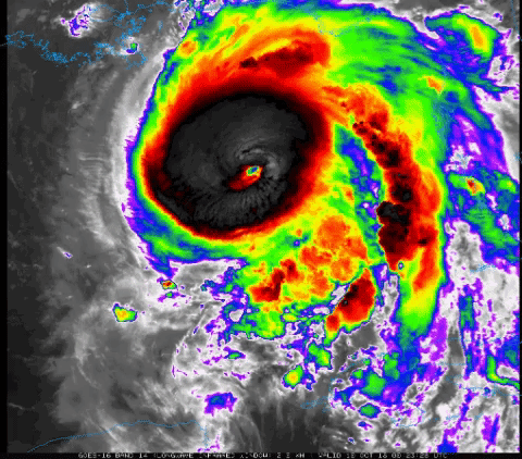
2018OCT10 000038 6.3 932.1 122.2 6.3 7.4 7.4 NO LIMIT OFF OFF OFF OFF -23.81 -77.60 EYE -99 IR 47.2 26.63 86.55 ARCHER GOES16 33.6
1 likes
ヤンデレ女が寝取られるているのを見たい!!!
ECMWF ensemble NWPAC plots: https://ecmwfensnwpac.imgbb.com/
Multimodel NWPAC plots: https://multimodelnwpac.imgbb.com/
GFS Ensemble NWPAC plots (16 & 35 day forecast): https://gefsnwpac.imgbb.com/
Plots updated automatically
ECMWF ensemble NWPAC plots: https://ecmwfensnwpac.imgbb.com/
Multimodel NWPAC plots: https://multimodelnwpac.imgbb.com/
GFS Ensemble NWPAC plots (16 & 35 day forecast): https://gefsnwpac.imgbb.com/
Plots updated automatically
-
supercane4867
- Category 5
- Posts: 4966
- Joined: Wed Nov 14, 2012 10:43 am
Re: ATL: MICHAEL - Hurricane - Discussion
Hayabusa wrote:2018OCT10 000038 6.3 932.1 122.2 6.3 7.4 7.4 NO LIMIT OFF OFF OFF OFF -23.81 -77.60 EYE -99 IR 47.2 26.63 86.55 ARCHER GOES16 33.6
A raw T# of 7.4 is one of the highest observed values in GOM
3 likes
-
northjaxpro
- S2K Supporter
- Posts: 8900
- Joined: Mon Sep 27, 2010 11:21 am
- Location: Jacksonville, FL
Re: ATL: MICHAEL - Hurricane - Discussion
supercane4867 wrote:northjaxpro wrote:130 KT FL winds!! I am completely in awe. I have not been speechless like this since tracking Patricia a couple of year ago in tge Eastern Pacific.
Historic tropical cyclone and one I am so terrified everyone dealing with this monster out in the Panhandle and Big Bend region. Godspeed!!!
Not downplaying this storm but I think I was more speechless when the 160kt SFMR came out from Irma
Yeah I remembered that report. Insane indeed.from Irma last year at her peak.. But, you don't often see super intense tropical cyclones like Michael in the Northeast GOM very often that is for darn sure!
Last edited by northjaxpro on Tue Oct 09, 2018 7:44 pm, edited 2 times in total.
2 likes
NEVER, EVER SAY NEVER in the tropics and weather in general, and most importantly, with life itself!!
________________________________________________________________________________________
Fay 2008 Beryl 2012 Debby 2012 Colin 2016 Hermine 2016 Julia 2016 Matthew 2016 Irma 2017 Dorian 2019
________________________________________________________________________________________
Fay 2008 Beryl 2012 Debby 2012 Colin 2016 Hermine 2016 Julia 2016 Matthew 2016 Irma 2017 Dorian 2019
-
Chris_in_Tampa
- Category 5
- Posts: 5101
- Age: 42
- Joined: Thu Jun 21, 2007 11:06 pm
- Location: Tampa, Florida, USA
- Contact:
Re: ATL: MICHAEL - Hurricane - Discussion
951mb, 19 knots of surface wind
UZNT13 KWBC 100028
XXAA 60008 99267 70865 08166 99951 27832 15019 00951 ///// /////
92244 26032 18020 85989 23248 19516 88999 77999
31313 09608 80015
61616 NOAA2 1214A MICHAEL OB 11
62626 CENTER MBL WND 17520 AEV 33668 DLM WND 19017 950751 WL150 1
6021 078 REL 2668N08651W 001524 SPG 2671N08650W 002059 =
XXBB 60008 99267 70865 08166 00951 27832 11850 23248 22751 19040
21212 00951 15019 11941 16023 22930 16519 33915 19019 44868 19020
55850 19516 66818 21016 77794 19014 88766 21514 99751 21015
31313 09608 80015
61616 NOAA2 1214A MICHAEL OB 11
62626 CENTER MBL WND 17520 AEV 33668 DLM WND 19017 950751 WL150 1
6021 078 REL 2668N08651W 001524 SPG 2671N08650W 002059 =
1 likes
-
CrazyC83
- Professional-Met

- Posts: 34316
- Joined: Tue Mar 07, 2006 11:57 pm
- Location: Deep South, for the first time!
Re: ATL: MICHAEL - Hurricane - Discussion
supercane4867 wrote:Hayabusa wrote:2018OCT10 000038 6.3 932.1 122.2 6.3 7.4 7.4 NO LIMIT OFF OFF OFF OFF -23.81 -77.60 EYE -99 IR 47.2 26.63 86.55 ARCHER GOES16 33.6
A raw T# of 7.4 is one of the highest observed values in GOM
It may BE the highest. I can't remember even Katrina or Rita having such cold cloud tops (but they had much better defined eyes). Wilma was probably the last storm to have that (if they could read the mini-pinhole) but that was at a much lower latitude.
1 likes

Re: ATL: MICHAEL - Hurricane - Discussion
Incredible finding by the NOAA recon in the NE quadrant, 150 mph at flight level is mind boggling and to think it has another 12-18 hours or so to keep strengthening.
1 likes
Re: ATL: MICHAEL - Hurricane - Discussion
Irma had days over the Atlantic. Michael had a day.
5 likes

Re: ATL: MICHAEL - Hurricane - Discussion
supercane4867 wrote:Hayabusa wrote:2018OCT10 000038 6.3 932.1 122.2 6.3 7.4 7.4 NO LIMIT OFF OFF OFF OFF -23.81 -77.60 EYE -99 IR 47.2 26.63 86.55 ARCHER GOES16 33.6
A raw T# of 7.4 is one of the highest observed values in GOM
Insanity!!!!!


1 likes
Who is online
Users browsing this forum: No registered users and 113 guests