ATL: MICHAEL - Post-Tropical - Discussion

Moderator: S2k Moderators

Message
Author
User avatar
terstorm1012
S2K Supporter
S2K Supporter
Posts: 1314
Age: 43
Joined: Fri Sep 10, 2004 5:36 pm
Location: Millersburg, PA

Re: ATL: MICHAEL - Hurricane - Discussion

#3781 Postby terstorm1012 » Wed Oct 10, 2018 2:11 pm

shiny-pebble wrote:How did Michael attain such a low pressure but not reach Cat 5? It wasn't too large either

Sent from my LG-H700 using Tapatalk


Winds sometimes lag behind pressure and since the lowest pressure occurred right at landfall, officially (for now) landfall intensity is 155mph.

I say for now because some evidence does exist for 135+kt surface winds, and we'll see in the post-analysis report. 2mph doesn't make a difference though, in terms of the catastrophic impact occurring right now.
1 likes   
my posts in this forum are NOT official forecast and should not be used as such. They are just my opinion (to which I welcome challenges!) and may or may not be backed by sound meteorological data. They are NOT endorsed by any professional institution or storm2k.org. For official information, please refer to the NHC and NWS products

supercane4867
Category 5
Category 5
Posts: 4966
Joined: Wed Nov 14, 2012 10:43 am

Re: ATL: MICHAEL - Hurricane - Discussion

#3782 Postby supercane4867 » Wed Oct 10, 2018 2:11 pm

shiny-pebble wrote:How did Michael attain such a low pressure but not reach Cat 5? It wasn't too large either

Sent from my LG-H700 using Tapatalk

Could be upgraded to CAT5 in post-season. 5kt is not much of a difference anyway
1 likes   

User avatar
Kazmit
Category 5
Category 5
Posts: 2124
Age: 22
Joined: Mon Jul 25, 2016 8:49 am
Location: Williamsburg, VA / Bermuda

Re: ATL: MICHAEL - Hurricane - Discussion

#3783 Postby Kazmit » Wed Oct 10, 2018 2:11 pm

shiny-pebble wrote:How did Michael attain such a low pressure but not reach Cat 5? It wasn't too large either

Sent from my LG-H700 using Tapatalk

I think it did reach cat 5 briefly, there's some evidence to support it. We'll have to see in post season analysis.
1 likes   
Igor 2010, Sandy 2012, Fay 2014, Gonzalo 2014, Joaquin 2015, Nicole 2016, Humberto 2019

I am only a tropical weather enthusiast. My predictions are not official and may or may not be backed by sound meteorological data. For official information, please refer to the NHC and NWS products.

supercane4867
Category 5
Category 5
Posts: 4966
Joined: Wed Nov 14, 2012 10:43 am

Re: ATL: MICHAEL - Hurricane - Discussion

#3784 Postby supercane4867 » Wed Oct 10, 2018 2:12 pm

Image
2 likes   

User avatar
NWFL56
Tropical Low
Tropical Low
Posts: 43
Joined: Thu Aug 25, 2016 4:42 pm

Re: ATL: MICHAEL - Hurricane - Discussion

#3785 Postby NWFL56 » Wed Oct 10, 2018 2:12 pm

Steve wrote:
HurricaneBrain wrote:
NDG wrote:His car got carried away or being moved around by the surge now!!!!!!

Link?


Brain,

The link has been posted like 15 times in the last few pages. It's nothing but the car bobbing. Bout to crash into another house.
https://livestormchasing.com/stream/brett.adair


The link isn't working for a lot of us. No idea why.
0 likes   

rhwxgeek
Tropical Low
Tropical Low
Posts: 39
Joined: Wed Oct 10, 2018 10:18 am

Re: ATL: MICHAEL - Hurricane - Discussion

#3786 Postby rhwxgeek » Wed Oct 10, 2018 2:13 pm

Tornado Warning as far south as Sarasota/Bradenton area

Tornado Warning
Tornado Warning
FLC081-115-101915-
/O.NEW.KTBW.TO.W.0007.181010T1857Z-181010T1915Z/

BULLETIN - EAS ACTIVATION REQUESTED
Tornado Warning
National Weather Service Tampa Bay Area Ruskin FL
257 PM EDT WED OCT 10 2018

The National Weather Service in Ruskin has issued a

* Tornado Warning for...
Central Manatee County in west central Florida...
Northern Sarasota County in west central Florida...

* Until 315 PM EDT.

* At 256 PM EDT, a severe thunderstorm capable of producing a tornado
was located over Sarasota Bradenton Airport, or near Sarasota,
moving northeast at 35 mph.

HAZARD...Tornado.

SOURCE...Radar indicated rotation.

IMPACT...Flying debris will be dangerous to those caught without
shelter. Mobile homes will be damaged or destroyed.
Damage to roofs, windows, and vehicles will occur. Tree
damage is likely.

* This dangerous storm will be near...
The Meadows around 300 PM EDT.
Lakewood Ranch around 305 PM EDT.

Other locations impacted by this tornadic thunderstorm include Desoto
Lakes.

PRECAUTIONARY/PREPAREDNESS ACTIONS...

TAKE COVER NOW! Move to an interior room on the lowest floor of a
sturdy building. Avoid windows. If you are outdoors, in a mobile
home, or in a vehicle, move to the closest substantial shelter and
protect yourself from flying debris.

&&

LAT...LON 2733 8255 2737 8260 2750 8248 2743 8237
TIME...MOT...LOC 1856Z 220DEG 30KT 2738 8254

TORNADO...RADAR INDICATED
HAIL...0.00IN

$$

TBW
1 likes   

User avatar
WxGuy1
Professional-Met
Professional-Met
Posts: 538
Joined: Sat Oct 22, 2005 12:55 pm
Location: Oklahoma

Re: ATL: MICHAEL - Hurricane - Discussion

#3787 Postby WxGuy1 » Wed Oct 10, 2018 2:15 pm

KC7NEC wrote:The two "good" things about this storm is its moving through very quickly and its daytime. Likely it will be safe enough and still light that rescues can begin in a few hours.

Not a Official or meteorologist. All opinions and statements are my own. Consult the experts.


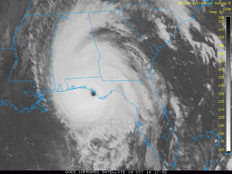
If there's any less-than-really-terrible news, it's that Michael has taken one of the "best" paths for minimizing the population in the right hemisphere of the eyewall (where the winds are almost always the strongest). You can pull up Google Earth or look at the satellite data in Google Maps and see that the area east of Panama City is mostly rural with extremely low population density (<10 people per sq. mile in areas). Of course, for those in the way, it doesn't really "help" at all, but, from a human impact perspective, this is a heck of a lot better of an outcome than if the hurricane made landfall 20-30 miles farther west, putting the much-more-populated Panama City area in the right eyewall with onshore winds.
Image
With a ~15 mph motion to the NE, a symmetric wind field would result in winds on the west side of the storm being ~30 mph weaker than on the east side. So, 150-155 mph max near Mexico Beach but ~120-125 mph max near Panama City. Add in the fact that the west side, in this case, had offshore flow (which is almost always meaningfully weaker than onshore flow -- it's way the strongest winds are almost always limited to areas right near the coast), and Panama City dodged a catastrophic bullet. That's of little consolation to those who will come back out to damaged or destroyed houses, but at least there are far fewer of those people than there would have been otherwise.
6 likes   

rhwxgeek
Tropical Low
Tropical Low
Posts: 39
Joined: Wed Oct 10, 2018 10:18 am

Re: ATL: MICHAEL - Hurricane - Discussion

#3788 Postby rhwxgeek » Wed Oct 10, 2018 2:16 pm

Starting to see some damage out of Panama City. Brick structures with significant damage...

 https://twitter.com/StormVisuals/status/1050101176681881600


1 likes   

User avatar
dhweather
S2K Supporter
S2K Supporter
Posts: 6199
Joined: Sat Aug 14, 2004 9:29 pm
Location: Heath, TX
Contact:

Re: ATL: MICHAEL - Hurricane - Discussion

#3789 Postby dhweather » Wed Oct 10, 2018 2:16 pm

Adair's car was submerged by the storm surge. He and his friend left the vehicle seeking higher ground as the storm surge rolled in, and left the video running. It kept working until the electronics got wet, then the stream died.
1 likes   
The above post and any post by dhweather is NOT an official forecast and should not be used as such. It is just the opinion of the poster and may or may not be backed by sound meteorological data. It is NOT endorsed by any professional institution including storm2k.org. For official information, please refer to NWS products.

Mouton
S2K Supporter
S2K Supporter
Posts: 221
Age: 79
Joined: Sat Jul 30, 2011 8:13 am
Location: Amelia Island Florida

Re: ATL: MICHAEL - Hurricane - Discussion

#3790 Postby Mouton » Wed Oct 10, 2018 2:17 pm

We just got a warning up in Nassau County.
1 likes   

User avatar
La Sirena
Category 1
Category 1
Posts: 307
Joined: Sun Aug 21, 2016 4:02 pm
Location: Formerly of the Keys, back home in East TN

Re: ATL: MICHAEL - Hurricane - Discussion

#3791 Postby La Sirena » Wed Oct 10, 2018 2:18 pm

NativeFloridaGirl wrote:
La Sirena wrote:
meriland29 wrote:i don't see any signs of it weakening....at all...since inland. Can someone verify that? are cities 30 miles inland going to get pretty much cat 5 weather just like the coast?

I would like to know lol. We’re 86 miles N of PCB roughly. We have a huge branch that came through our pool cage at 10 am CST. Lost internet and cable at noon. We know it’s gojng to get a lot worse later for us. Looking at some pretty crazy winds.


And everyone is talking about how it’s going to turn Northeast. When? I’m also in Dothan and huge branches are already crashing all around my house. My internet also went out around noon and now the power is blinking. I’m concerned that Michael isn’t playing by the rules.

No kidding he’s not even delivered his worst yet to is in Dothan. Hang tight y’all.
1 likes   
The posts in this forum are NOT official forecasts and should not be used as such. They are just the opinion of the poster and may or may not be backed by sound meteorological data. They are NOT endorsed by any professional institution or STORM2K. For official information, please refer to products from the NHC and NWS.

rhwxgeek
Tropical Low
Tropical Low
Posts: 39
Joined: Wed Oct 10, 2018 10:18 am

Re: ATL: MICHAEL - Hurricane - Discussion

#3792 Postby rhwxgeek » Wed Oct 10, 2018 2:20 pm

Tornado warnings spreading into South Central GA already, tornado warning for Perry, GA area. For perspective that is about 30 miles south of Macon.

Also this video out of Mexico Beach from Ginger Zee of ABC.

 https://twitter.com/Ginger_Zee/status/1050101892167151616


2 likes   

User avatar
birdwomn
Category 1
Category 1
Posts: 419
Joined: Wed Aug 11, 2004 8:04 pm
Location: Pinellas County FL

Re: ATL: MICHAEL - Hurricane - Discussion

#3793 Postby birdwomn » Wed Oct 10, 2018 2:22 pm

0 likes   

storminabox
Category 1
Category 1
Posts: 263
Joined: Sun Jul 09, 2017 10:50 pm

Re: ATL: MICHAEL - Hurricane - Discussion

#3794 Postby storminabox » Wed Oct 10, 2018 2:23 pm

So much for a dead hurricane season. Truly a mesmerizing storm!
4 likes   

taveanator
Tropical Low
Tropical Low
Posts: 10
Joined: Mon May 23, 2011 3:56 pm

Re: ATL: MICHAEL - Hurricane - Discussion

#3795 Postby taveanator » Wed Oct 10, 2018 2:24 pm

Here's the cached video:

https://www.facebook.com/foxsanantonio/ ... 649794753/
&
https://www.facebook.com/foxsanantonio/ ... 334103158/

and here's where they ended up:

https://www.google.com/maps/@29.919818, ... 312!8i6656

Looks like a fairly modern house, so I'm cautiously optimistic.
Last edited by taveanator on Wed Oct 10, 2018 2:28 pm, edited 1 time in total.
2 likes   

User avatar
cycloneye
Admin
Admin
Posts: 143891
Age: 68
Joined: Thu Oct 10, 2002 10:54 am
Location: San Juan, Puerto Rico

Re: ATL: MICHAEL - Hurricane - Discussion

#3796 Postby cycloneye » Wed Oct 10, 2018 2:24 pm

This is the crew that flew the last mission. Kudos to all from Air Force and NOAA that made an amazing work collecting the data.

 https://twitter.com/JeremyDeHart53d/status/1050103589048344576


13 likes   
Visit the Caribbean-Central America Weather Thread where you can find at first post web cams,radars
and observations from Caribbean basin members Click Here

User avatar
Kingarabian
S2K Supporter
S2K Supporter
Posts: 15829
Joined: Sat Aug 08, 2009 3:06 am
Location: Honolulu, Hawaii

Re: ATL: MICHAEL - Hurricane - Discussion

#3797 Postby Kingarabian » Wed Oct 10, 2018 2:25 pm

Prayers to all those affect by Michael. What a season it has been...
2 likes   
RIP Kobe Bryant

Smith,J
Tropical Wave
Tropical Wave
Posts: 6
Joined: Thu Aug 02, 2007 6:48 am

Re: ATL: MICHAEL - Hurricane - Discussion

#3798 Postby Smith,J » Wed Oct 10, 2018 2:26 pm

Buck wrote:Eager to see photos and hear reports of Cape San Blas, Port St. Joe, Indian Pass, etc. Places very near and dear to my heart.


I wonder if Indian Pass Raw Bar is gone????
0 likes   

User avatar
HurricaneEnzo
Category 2
Category 2
Posts: 739
Joined: Wed Mar 14, 2018 12:18 pm
Location: Newport, NC (Hurricane Alley)

Re: ATL: MICHAEL - Hurricane - Discussion

#3799 Postby HurricaneEnzo » Wed Oct 10, 2018 2:27 pm

Looks like Georgia will be getting its strongest Hurricane since 1898. Perhaps the strongest in recorded history depending on how well Michael continues to hold together. Didn't come from the Atlantic side either but the Gulf side. Crazy stuff.
5 likes   
Bertha 96' - Fran 96' - Bonnie 98' - Dennis 99' - Floyd 99' - Isabel 03' - Alex 04' - Ophelia 05' - Irene 11' - Arthur 14' - Matthew 16' - Florence 18' - Dorian 19' - Isaias 20' (countless other tropical storms and Hurricane swipes)

I am not a Professional Met just an enthusiast. Get your weather forecasts from the Pros!

Chris_in_Tampa
Category 5
Category 5
Posts: 5075
Age: 41
Joined: Thu Jun 21, 2007 11:06 pm
Location: Tampa, Florida, USA
Contact:

Re: ATL: MICHAEL - Hurricane - Discussion

#3800 Postby Chris_in_Tampa » Wed Oct 10, 2018 2:30 pm

Jim Williams starting to drive around:
https://www.pscp.tv/HurricaneCity/
0 likes   


Return to “2018”

Who is online

Users browsing this forum: No registered users and 53 guests