AL, 14, 2018101200, , BEST, 0, 365N, 777W, 45, 988, TS
ATL: MICHAEL - Post-Tropical - Discussion
Moderator: S2k Moderators
-
cycloneye

- Admin

- Posts: 149500
- Age: 69
- Joined: Thu Oct 10, 2002 10:54 am
- Location: San Juan, Puerto Rico
Re: ATL: MICHAEL - Tropical Storm - Discussion
MIchael still alive as a Tropical Storm.
2 likes
Visit the Caribbean-Central America Weather Thread where you can find at first post web cams,radars
and observations from Caribbean basin members Click Here
and observations from Caribbean basin members Click Here
-
USTropics
- Professional-Met

- Posts: 2738
- Joined: Sun Aug 12, 2007 3:45 am
- Location: Florida State University
Re: ATL: MICHAEL - Tropical Storm - Discussion
A lot of these homes I'm seeing on google streets (where there are just slabs left) are one story, wood framed houses. You can see in this video the surge has pushed some of these houses into the main street (there are boats that were carried on top of roofs as well).
https://www.youtube.com/watch?v=lh-MPQvM5bI
I've put google maps in the center of where the drone takes off at, you can follow it along the path with google maps. It's quite devastating how many homes have been completely wiped off of their foundations:
https://www.google.com/maps/@29.9521219,-85.4244482,650a,35y,270h/data=!3m1!1e3
1 likes
-
otowntiger
- Category 5

- Posts: 1932
- Joined: Tue Aug 31, 2004 7:06 pm
Re: ATL: MICHAEL - Tropical Storm - Discussion
nascarfan999 wrote:Personally I believe there is strong enough evidence for an upgrade to cat 5 with the most detailed case laid out by one of our pros late last night several pages back. That said, one thing I want to point out is to keep in mind that the destruction several posters today have referred to as their reason for an upgrade is the damage in Mexico Beach. However, I would argue that a lot of the "total destruction" that is there was due to the surge as much if not more than the wind.
Have you seen some of the chaser video? The wind was every bit as destructive as the surge. At 155mph the storm was essentially a giant tornado rolling thru.
1 likes
-
cycloneye
- Admin
- Posts: 149500
- Age: 69
- Joined: Thu Oct 10, 2002 10:54 am
- Location: San Juan, Puerto Rico
Re: ATL: MICHAEL - Tropical Storm - Discussion
Josh says between Maria and MIchael chases, the ladder one was more violent.
https://twitter.com/iCyclone/status/1050561277028982784
https://twitter.com/iCyclone/status/1050561277028982784
3 likes
Visit the Caribbean-Central America Weather Thread where you can find at first post web cams,radars
and observations from Caribbean basin members Click Here
and observations from Caribbean basin members Click Here
-
nascarfan999
- Tropical Low

- Posts: 44
- Joined: Fri Sep 02, 2016 1:36 pm
Re: ATL: MICHAEL - Tropical Storm - Discussion
otowntiger wrote:nascarfan999 wrote:Personally I believe there is strong enough evidence for an upgrade to cat 5 with the most detailed case laid out by one of our pros late last night several pages back. That said, one thing I want to point out is to keep in mind that the destruction several posters today have referred to as their reason for an upgrade is the damage in Mexico Beach. However, I would argue that a lot of the "total destruction" that is there was due to the surge as much if not more than the wind.
Have you seen some of the chaser video? The wind was every bit as destructive as the surge. At 155mph the storm was essentially a giant tornado rolling thru.
Since you skipped my first sentence, let me reiterate that "Personally I believe there is strong enough evidence for an upgrade to cat 5". I just wanted to remind people that the Mexico Beach damage was aided by the surge.
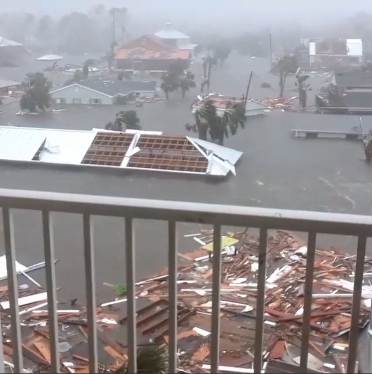
On that note, I don't know how accurate it is, but Google Earth shows an elevation of much of Mexico Beach between the ocean and Highway 98 as being 10-11 feet. Considering the below picture shows water near some rooflines, I would think that water is 8-10 feet above the ground and thus around 20 feet above sea level. I couldn't find the exact location of the below picture to confirm, so maybe it is a touch lower, but almost every structure looks to be at 7 feet or above (again, based on Google Earth).
https://twitter.com/paulstorms/status/1050097048689631232
3 likes
-
SconnieCane
- Category 5
- Posts: 1013
- Joined: Thu Aug 02, 2018 5:29 pm
- Location: Madison, WI
Re: ATL: MICHAEL - Tropical Storm - Discussion
Some of the most dramatic eyewall and damage video I've seen yet. For some reason won't embed.
https://www.youtube.com/watch?v=YrSMz9DZX8o
https://www.youtube.com/watch?v=YrSMz9DZX8o
8 likes
Re: ATL: MICHAEL - Tropical Storm - Discussion
Satellite/Aerial photos from today of the area
https://storms.ngs.noaa.gov/storms/mich ... /-85.40288
St. Joseph's Peninsula is no longer a peninsula.
https://twitter.com/cfhc/status/1050578049316610048
https://storms.ngs.noaa.gov/storms/mich ... /-85.40288
St. Joseph's Peninsula is no longer a peninsula.
https://twitter.com/cfhc/status/1050578049316610048
Last edited by BobHarlem on Thu Oct 11, 2018 9:45 pm, edited 1 time in total.
6 likes
-
DestinHurricane

- Category 4

- Posts: 935
- Joined: Tue May 01, 2018 8:05 am
- Location: New York, NY
Re: ATL: MICHAEL - Tropical Storm - Discussion
Agua wrote:DestinHurricane wrote:Guy who works for my family's painting company genuinely believes "the government is making the hurricanes stronger" More BS than flat earthers.
Let me say I agree, but my mind has wandered back to the time of Katrina.
This was when it was TD 10 - it may have even been *before* it dissapated, then reorganized as TD 10.
There was some poster on here that kept repeating something about it was going to destroy New Orleans and would bring complete destruction. Seems like, and I could be conflating something here, but seems like the poster was suggesting he/she was Russian and that it was being directed by Russia(?). Whoever it was was not offering any meteorological rationale whatsoever. I know that is all nuts, and the poster was banned pretty quickly, but does any one else remember this incident? After the storm, I obviously had many other things to be concerned with, but every once in a while, my mind will go back to that eerie and strangely accurate prediction.
Were the posts deleted?
0 likes
Michael 2018
-
supercane4867
- Category 5
- Posts: 4966
- Joined: Wed Nov 14, 2012 10:43 am
Re: ATL: MICHAEL - Tropical Storm - Discussion
Brett Adair with Live Storms Media have uploaded many good damage videos
https://www.youtube.com/watch?v=7y-ARvbdBvQ
https://www.youtube.com/watch?v=bkbR0RjwmiQ
https://www.youtube.com/watch?v=7h9GhPHoSTc
https://www.youtube.com/watch?v=13UoLG4assM
https://www.youtube.com/watch?v=nNvQY10gtT4
https://www.youtube.com/watch?v=13UoLG4assM
https://www.youtube.com/watch?v=7y-ARvbdBvQ
https://www.youtube.com/watch?v=bkbR0RjwmiQ
https://www.youtube.com/watch?v=7h9GhPHoSTc
https://www.youtube.com/watch?v=13UoLG4assM
https://www.youtube.com/watch?v=nNvQY10gtT4
https://www.youtube.com/watch?v=13UoLG4assM
0 likes


Re: ATL: MICHAEL - Tropical Storm - Discussion
DestinHurricane wrote:Agua wrote:DestinHurricane wrote:Guy who works for my family's painting company genuinely believes "the government is making the hurricanes stronger" More BS than flat earthers.
Let me say I agree, but my mind has wandered back to the time of Katrina.
This was when it was TD 10 - it may have even been *before* it dissapated, then reorganized as TD 10.
There was some poster on here that kept repeating something about it was going to destroy New Orleans and would bring complete destruction. Seems like, and I could be conflating something here, but seems like the poster was suggesting he/she was Russian and that it was being directed by Russia(?). Whoever it was was not offering any meteorological rationale whatsoever. I know that is all nuts, and the poster was banned pretty quickly, but does any one else remember this incident? After the storm, I obviously had many other things to be concerned with, but every once in a while, my mind will go back to that eerie and strangely accurate prediction.
Were the posts deleted?

0 likes
Andy D
(For official information, please refer to the NHC and NWS products.)
(For official information, please refer to the NHC and NWS products.)
-
floridasun78
- Category 5
- Posts: 3755
- Joined: Sun May 17, 2009 10:16 pm
- Location: miami fl
Re: ATL: MICHAEL - Tropical Storm - Discussion
afb look homestead afb after andrew (afb mean afbforce base)
1 likes
-
Meteorcane

- Category 2

- Posts: 559
- Joined: Thu Jul 21, 2011 6:49 am
- Location: North Platte Nebraska
Re: ATL: MICHAEL - Tropical Storm - Discussion
SIAP
NOAA has released their post-storm satellite imagery mosaic, if you want to see the damage imagery stitched together (obviously with mediocre resolution relative to helicopter/drone footage). https://storms.ngs.noaa.gov/storms/michael/index.html#19/30.14238/-85.60311
The gradients in damage are pretty striking, resulting first and foremost from where the eyewall impacted for example there is a transition from Cat 1-2 type damage on Panama City beach to Cat 3 damage in Panama City proper. Also you can notice a lot of smaller-scale gradients in damage likely resulting from microscale storm/terrain features (such as mesovorticies), and building construction.
Similar to what we have observed so far from better resolution imagery it looks like Tyndall AFB, and the Callaway area were the most significantly impacted from a pure wind damage standpoint, I would say the damage there is solid Cat.4. I should note it is really tough to assess wind damage in areas east of the center (e.g. Mexico Beach and St.Joe Beach) because of the effects of the surge. However, I would not be surprised if given the convective structure of the eyewall at the time of landfall that locations on the western/northern side of the eyewall experienced similar if not greater winds than areas in the usually favored right-front quadrant received.
4 likes
-
bamajammer4eva
- Category 4
- Posts: 907
- Joined: Sun Apr 18, 2010 3:21 am
- Location: Ozark, AL
Re: ATL: MICHAEL - Tropical Storm - Discussion
It seems this was all just a poor ignored Michael throwing a temper tantrum! In 2000 he crashed ashore in Newfoundland as a category 1 with 85 mph winds and the NHC called him a wimp (lost tropical characteristics). He's 18 now and got his revenge. I have a suspicion however that he'll still be forbidden from storm name rotation from here on out after this behavior! 
HURRICANE MICHAEL SPECIAL DISCUSSION NUMBER 14
NATIONAL WEATHER SERVICE MIAMI FL
830 PM EDT THU OCT 19 2000
SURFACE OBSERVATIONS INDICATE THAT MICHAEL ACQUIRED A FRONTAL
STRUCTURE JUST BEFORE REACHING NEWFOUNDLAND AND IS NO LONGER A
TROPICAL CYCLONE. THIS WILL BE THE LAST ADVISORY ON MICHAEL. THE
FRONTAL CYCLONE REMNANT LOW IS CURRENTLY OVER LAND AND MOVING AT
020/40. THERE WAS A RECENT REPORT OF 70 KT AT AN ELEVATION OF 35
METERS JUST TO THE RIGHT OF THE CENTER BEFORE IT MADE LANDFALL.
FORECASTER FRANKLIN
FORECAST POSITIONS AND MAX WINDS
INITIAL 20/0030Z 48.5N 56.5W 75 KTS...EXTRATROPICAL...
2 likes
-
bamajammer4eva
- Category 4
- Posts: 907
- Joined: Sun Apr 18, 2010 3:21 am
- Location: Ozark, AL
Re: ATL: MICHAEL - Tropical Storm - Discussion
Wow i followed the link posted above and cant believe the scenes. Here is Pineapple Willy's which actually looks salvageable and the unfortunate condo I stayed in a few years ago 

0 likes
-
Meteorcane
- Category 2
- Posts: 559
- Joined: Thu Jul 21, 2011 6:49 am
- Location: North Platte Nebraska
Re: ATL: MICHAEL - Tropical Storm - Discussion
bamajammer4eva wrote:Wow i followed the link posted above and cant believe the scenes. Here is Pineapple Willy's which actually looks salvageable and the unfortunate condo I stayed in a few years ago
https://i.imgur.com/Re6ZPbK.png
Lol nice catch, clearly their image mosaicking technique is not perfect.
1 likes
-
tolakram
- Admin
- Posts: 20186
- Age: 62
- Joined: Sun Aug 27, 2006 8:23 pm
- Location: Florence, KY (name is Mark)
Re: ATL: MICHAEL - Tropical Storm - Discussion
DestinHurricane wrote:Agua wrote:DestinHurricane wrote:Guy who works for my family's painting company genuinely believes "the government is making the hurricanes stronger" More BS than flat earthers.
Let me say I agree, but my mind has wandered back to the time of Katrina.
This was when it was TD 10 - it may have even been *before* it dissapated, then reorganized as TD 10.
There was some poster on here that kept repeating something about it was going to destroy New Orleans and would bring complete destruction. Seems like, and I could be conflating something here, but seems like the poster was suggesting he/she was Russian and that it was being directed by Russia(?). Whoever it was was not offering any meteorological rationale whatsoever. I know that is all nuts, and the poster was banned pretty quickly, but does any one else remember this incident? After the storm, I obviously had many other things to be concerned with, but every once in a while, my mind will go back to that eerie and strangely accurate prediction.
Were the posts deleted?
Moved, and warnings issued or posters banned.
Let me be perfectly clear, even to those who are just having fun with some of this conspiracy crap. It's a fine line between just mentioning some crazy stupid thing and then enabling other posters to start piling on to the quacked conspiracy theory of the week. There's plenty of other places on the interweb if people feel like it's fun to talk about, but not here.
10 likes
M a r k
- - - - -
Join us in chat: Storm2K Chatroom Invite. Android and IOS apps also available.
The posts in this forum are NOT official forecasts and should not be used as such. Posts are NOT endorsed by any professional institution or STORM2K.org. For official information and forecasts, please refer to NHC and NWS products.
-
USTropics
- Professional-Met
- Posts: 2738
- Joined: Sun Aug 12, 2007 3:45 am
- Location: Florida State University
Re: ATL: MICHAEL - Post-Tropical - Discussion
Created a 140 frame gif animation from Michael's initiation in the Caribbean through today (large image size ~70mb, in GEO Color):
https://cardse.net/i/2018/10/12/5429d3c93570a2e97a8194bcc60f9ac1.gif
https://cardse.net/i/2018/10/12/5429d3c93570a2e97a8194bcc60f9ac1.gif
6 likes
-
cycloneye
- Admin
- Posts: 149500
- Age: 69
- Joined: Thu Oct 10, 2002 10:54 am
- Location: San Juan, Puerto Rico
Re: ATL: MICHAEL - Post-Tropical - Discussion
Sad news to report as the death toll rises to 12.Rest in peace their souls.
https://twitter.com/Reuters/status/1050722797746626560
https://twitter.com/Reuters/status/1050722797746626560
0 likes
Visit the Caribbean-Central America Weather Thread where you can find at first post web cams,radars
and observations from Caribbean basin members Click Here
and observations from Caribbean basin members Click Here
-
PandaCitrus
- Category 1

- Posts: 424
- Joined: Mon Sep 04, 2017 2:44 pm
Re: ATL: MICHAEL - Post-Tropical - Discussion
On that note, I don't know how accurate it is, but Google Earth shows an elevation of much of Mexico Beach between the ocean and Highway 98 as being 10-11 feet. Considering the below picture shows water near some rooflines, I would think that water is 8-10 feet above the ground and thus around 20 feet above sea level. I couldn't find the exact location of the below picture to confirm, so maybe it is a touch lower, but almost every structure looks to be at 7 feet or above (again, based on Google Earth).
You are correct. I went to google earth and compared to the NOAA satellite imagery of the damage posted earlier. All of the homes I see that are now concrete slabs with nothing but foundations were on at least 8 feet elevation. And many of them were higher. 9 feet to 10 feet. Some were 12 feet.
Considering the SLOSH model for Cat 5 maxes out at 20 feet in this area. If the google elevations are accurate, it's possible the surge was approaching 20 feet in certain areas to do this damage.
0 likes
-
PandaCitrus
- Category 1
- Posts: 424
- Joined: Mon Sep 04, 2017 2:44 pm
Re: ATL: MICHAEL - Post-Tropical - Discussion
Another data point for surge.
On the NOAA damage map, this area is at 19 and 20 feet elevation according to Google Earth. It is further south of Mexico Beach. The homes appear to have wind damage and the Surge appears to have reached US 98 (Elevation 19 and 20 feet) and broken it apart in certain sections.
https://storms.ngs.noaa.gov/storms/mich ... /-85.39830
0 likes
Who is online
Users browsing this forum: No registered users and 189 guests