I have a feeling that we may well see a powerful, late-October system that curves into Mexico à la Patricia (2015). The long-range ECMWF is hinting at this.
Given favourably low vertical wind shear and the largely undisturbed thermocline offshore of Mexico, a compact, stacked system could intensify explosively.
2018 EPAC Season
Moderator: S2k Moderators
Forum rules

The posts in this forum are NOT official forecasts and should not be used as such. They are just the opinion of the poster and may or may not be backed by sound meteorological data. They are NOT endorsed by any professional institution or STORM2K. For official information, please refer to products from the National Hurricane Center and National Weather Service.
-
Shell Mound
- Category 5

- Posts: 2432
- Age: 33
- Joined: Thu Sep 07, 2017 3:39 pm
- Location: St. Petersburg, FL → Scandinavia
Re: 2018 EPAC Season
Last edited by Shell Mound on Fri Oct 12, 2018 3:33 pm, edited 1 time in total.
3 likes
CVW / MiamiensisWx / Shell Mound
The posts in this forum are NOT official forecasts and should not be used as such. They are just the opinion of the poster and may or may not be backed by sound meteorological data. They are NOT endorsed by any professional institution or STORM2K. For official information, please refer to products from the NHC and NWS.


Re: 2018 EPAC Season
Shell Mound wrote:I have a feeling that we may well see a powerful, late-October system that curves into Mexico à la Patricia (2015). The long-range ECMWF is hinting at this.
We've been waiting for this to show up. It's been lurking in the background. It's almost signature El Nino to get something very strong paralleling the southwest Mexican coast late in the season Like Linda, Rick, and Patricia.
2 likes
The above post and any post by Ntxw is NOT an official forecast and should not be used as such. It is just the opinion of the poster and may or may not be backed by sound meteorological data. It is NOT endorsed by any professional institution including Storm2k. For official information, please refer to NWS products.
Help support Storm2K!
-
Shell Mound
- Category 5
- Posts: 2432
- Age: 33
- Joined: Thu Sep 07, 2017 3:39 pm
- Location: St. Petersburg, FL → Scandinavia
Re: 2018 EPAC Season
Ntxw wrote:Shell Mound wrote:I have a feeling that we may well see a powerful, late-October system that curves into Mexico à la Patricia (2015). The long-range ECMWF is hinting at this.
We've been waiting for this to show up. It's been lurking in the background. It's almost signature El Nino to get something very strong paralleling the southwest Mexican coast late in the season Like Linda, Rick, and Patricia.
Let's say Michael is posthumously upgraded to Cat-5 status (140 knots) at landfall and we get the most prolific ACE index for the EPAC on record and a Cat-5, late-October system makes landfall on the Pacific side of Mexico. The very fact that this even has a possibility, however slim, of verifying makes one pause. This kind of combination would be quite remarkable, given a well-above-average EPAC and a slightly-above-average Atlantic, with El Niño present. As it currently stands, 2018 will easily go down as among the rarest, most remarkable, and, unfortunately, destructive EPAC/Atlantic combinations on record. Somehow, Michael would make a fitting and harrowing parallel to a sister system on the Pacific coast of Mexico. (Another ridiculous fact: the 2018 EPAC name list contains "Yolanda," which was the Filipino designation for Typhoon Haiyan in 2013. "Willa," which sounds a bit like Wilma, is also on this year's EPAC list. The upcoming name is "Tara.")
3 likes
CVW / MiamiensisWx / Shell Mound
The posts in this forum are NOT official forecasts and should not be used as such. They are just the opinion of the poster and may or may not be backed by sound meteorological data. They are NOT endorsed by any professional institution or STORM2K. For official information, please refer to products from the NHC and NWS.
Re: 2018 EPAC Season
Shell Mound wrote:Ntxw wrote:Shell Mound wrote:I have a feeling that we may well see a powerful, late-October system that curves into Mexico à la Patricia (2015). The long-range ECMWF is hinting at this.
We've been waiting for this to show up. It's been lurking in the background. It's almost signature El Nino to get something very strong paralleling the southwest Mexican coast late in the season Like Linda, Rick, and Patricia.
Let's say Michael is posthumously upgraded to Cat-5 status (140 knots) at landfall and we get the most prolific ACE index for the EPAC on record and a Cat-5, late-October system makes landfall on the Pacific side of Mexico. The very fact that this even has a possibility, however slim, of verifying makes one pause. This kind of combination would be quite remarkable, given a well-above-average EPAC and a slightly-above-average Atlantic, with El Niño present. As it currently stands, 2018 will easily go down as among the rarest, most remarkable, and, unfortunately, destructive EPAC/Atlantic combinations on record. Somehow, Michael would make a fitting and harrowing parallel to a sister system on the Pacific coast of Mexico. (Another ridiculous fact: the 2018 EPAC name list contains "Yolanda," which was the Filipino designation for Typhoon Haiyan in 2013. "Willa," which sounds a bit like Wilma, is also on this year's EPAC list. The upcoming name is "Tara.")
It's no doubt warming SSTs have played a significant role. The poleward expansion of the Hadley cell and SSTs moving north/warming have extended, as well as allowed a better life for such systems. The tropics have moved northward some. Your typical "El Nino" or "La Nina" patterns don't work entirely the same way as it has in years past.
7 likes
The above post and any post by Ntxw is NOT an official forecast and should not be used as such. It is just the opinion of the poster and may or may not be backed by sound meteorological data. It is NOT endorsed by any professional institution including Storm2k. For official information, please refer to NWS products.
Help support Storm2K!
Help support Storm2K!
Re: 2018 EPAC Season
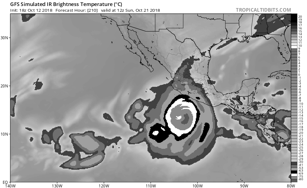
Here is "Tara" on the 18z GFS in the holy waters of the EPAC intensifying quickly.
6 likes
The above post and any post by Ntxw is NOT an official forecast and should not be used as such. It is just the opinion of the poster and may or may not be backed by sound meteorological data. It is NOT endorsed by any professional institution including Storm2k. For official information, please refer to NWS products.
Help support Storm2K!
Help support Storm2K!
-
cycloneye

- Admin

- Posts: 149508
- Age: 69
- Joined: Thu Oct 10, 2002 10:54 am
- Location: San Juan, Puerto Rico
Re: 2018 EPAC Season
0 likes
Visit the Caribbean-Central America Weather Thread where you can find at first post web cams,radars
and observations from Caribbean basin members Click Here
and observations from Caribbean basin members Click Here
Re: 2018 EPAC Season
In a weird twist 98E the models do try to develop before being enveloped or mingling with the big one behind it. It's possible 98E may become Tara first, making the second larger one as Vicente.
However only the 0z suite really tried to do this so waiting game and see.
However only the 0z suite really tried to do this so waiting game and see.
3 likes
The above post and any post by Ntxw is NOT an official forecast and should not be used as such. It is just the opinion of the poster and may or may not be backed by sound meteorological data. It is NOT endorsed by any professional institution including Storm2k. For official information, please refer to NWS products.
Help support Storm2K!
Help support Storm2K!
-
cycloneye
- Admin
- Posts: 149508
- Age: 69
- Joined: Thu Oct 10, 2002 10:54 am
- Location: San Juan, Puerto Rico
Re: 2018 EPAC Season
I guess the one the models develop as a strong hurricane will begin to be mentioned in the next TWO as 12z GFS is inside 5 days now.

0 likes
Visit the Caribbean-Central America Weather Thread where you can find at first post web cams,radars
and observations from Caribbean basin members Click Here
and observations from Caribbean basin members Click Here
-
cycloneye
- Admin
- Posts: 149508
- Age: 69
- Joined: Thu Oct 10, 2002 10:54 am
- Location: San Juan, Puerto Rico
Re: 2018 EPAC Season
Already at 969 mbs at 168 hours.

0 likes
Visit the Caribbean-Central America Weather Thread where you can find at first post web cams,radars
and observations from Caribbean basin members Click Here
and observations from Caribbean basin members Click Here
-
cycloneye
- Admin
- Posts: 149508
- Age: 69
- Joined: Thu Oct 10, 2002 10:54 am
- Location: San Juan, Puerto Rico
Re: 2018 EPAC Season
Down to 942 mbs in 192 hours.

0 likes
Visit the Caribbean-Central America Weather Thread where you can find at first post web cams,radars
and observations from Caribbean basin members Click Here
and observations from Caribbean basin members Click Here
-
cycloneye
- Admin
- Posts: 149508
- Age: 69
- Joined: Thu Oct 10, 2002 10:54 am
- Location: San Juan, Puerto Rico
Re: 2018 EPAC Season
Getting closer to Patricia 2015 territory.922 mbs at 216 hours.

0 likes
Visit the Caribbean-Central America Weather Thread where you can find at first post web cams,radars
and observations from Caribbean basin members Click Here
and observations from Caribbean basin members Click Here
-
cycloneye
- Admin
- Posts: 149508
- Age: 69
- Joined: Thu Oct 10, 2002 10:54 am
- Location: San Juan, Puerto Rico
Re: 2018 EPAC Season
Is a big threat to Los Cabos/BCS and Sinaloa if it goes that way and be this strong. An Odile 2014 type that the area saw.

0 likes
Visit the Caribbean-Central America Weather Thread where you can find at first post web cams,radars
and observations from Caribbean basin members Click Here
and observations from Caribbean basin members Click Here
-
cycloneye
- Admin
- Posts: 149508
- Age: 69
- Joined: Thu Oct 10, 2002 10:54 am
- Location: San Juan, Puerto Rico
Re: 2018 EPAC Season
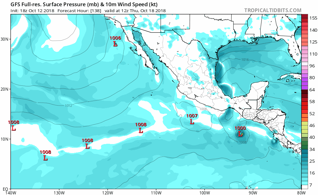
Here is the first mention.
A low pressure area is forecast to develop a few hundred miles south
of the southeastern coast of Mexico around the middle of next week.
Environmental conditions are expected to be somewhat favorable for
development of the system while it moves generally westward, well
offshore the coast of Mexico.
* Formation chance through 48 hours...low...near 0 percent.
* Formation chance through 5 days...low...20 percent
0 likes
Visit the Caribbean-Central America Weather Thread where you can find at first post web cams,radars
and observations from Caribbean basin members Click Here
and observations from Caribbean basin members Click Here
-
EquusStorm
- Category 5
- Posts: 1649
- Age: 35
- Joined: Thu Nov 07, 2013 1:04 pm
- Location: Jasper, AL
- Contact:
Re: 2018 EPAC Season
This year could be our best chance in a long time to get past the W and enter the auxiliary XYZ, if we remain active into November
1 likes
Colors of lost purpose on the canvas of irrelevance
Not a meteorologist, in fact more of an idiot than anything. You should probably check with the NHC or a local NWS office for official information.
Not a meteorologist, in fact more of an idiot than anything. You should probably check with the NHC or a local NWS office for official information.
-
Kingarabian

- S2K Supporter

- Posts: 16366
- Joined: Sat Aug 08, 2009 3:06 am
- Location: Honolulu, Hawaii
Re: 2018 EPAC Season
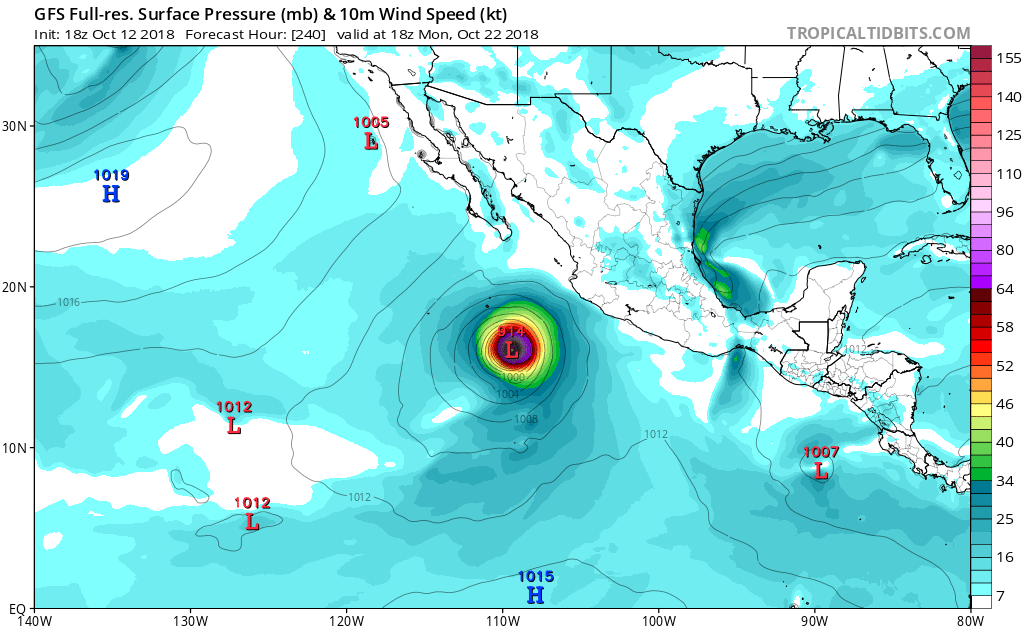
cycloneye wrote:Getting closer to Patricia 2015 territory.922 mbs at 216 hours.
https://i.imgur.com/pBc7TVI.png
May have a shot at being the strongest storm of the 2018 EPAC season. Don't think the GFS showed any sub 900 pressures for Patricia in its developing stages.
5 likes
RIP Kobe Bryant
-
cycloneye
- Admin
- Posts: 149508
- Age: 69
- Joined: Thu Oct 10, 2002 10:54 am
- Location: San Juan, Puerto Rico
Re: 2018 EPAC Season
18z GFS is stronger than 12z.At 192 hours,926 mbs at 18z vs 942 mbs at 12z.

0 likes
Visit the Caribbean-Central America Weather Thread where you can find at first post web cams,radars
and observations from Caribbean basin members Click Here
and observations from Caribbean basin members Click Here
-
cycloneye
- Admin
- Posts: 149508
- Age: 69
- Joined: Thu Oct 10, 2002 10:54 am
- Location: San Juan, Puerto Rico
Re: 2018 EPAC Season
Below the 920's.

0 likes
Visit the Caribbean-Central America Weather Thread where you can find at first post web cams,radars
and observations from Caribbean basin members Click Here
and observations from Caribbean basin members Click Here
-
SconnieCane
- Category 5
- Posts: 1013
- Joined: Thu Aug 02, 2018 5:29 pm
- Location: Madison, WI

Re: 2018 EPAC Season
It would be fitting if Tara formed first and the big one was named Vicente. It's been the male names this year that have been reaching for or achieving Cat 5 status. Hector, Lane, Norman, and I believe Walaka is traditionally a male name as well.
I would just like to see the basin reach the Greek. Might as well do that too while breaking the ACE record. Hopefully all future storms stay away from Mexico though. Some of these model runs are looking ominous for Mexico/Baja.
I would just like to see the basin reach the Greek. Might as well do that too while breaking the ACE record. Hopefully all future storms stay away from Mexico though. Some of these model runs are looking ominous for Mexico/Baja.
2 likes
Solar Aquarian
Lunar Cancerian
 Sagittarian
Lunar Cancerian
-
cycloneye
- Admin
- Posts: 149508
- Age: 69
- Joined: Thu Oct 10, 2002 10:54 am
- Location: San Juan, Puerto Rico
Re: 2018 EPAC Season
A low pressure area is forecast to develop a few hundred miles south
of the southeastern coast of Mexico around the middle of next week.
Environmental conditions are expected to be somewhat favorable for
development of the system while it moves generally westward,
parallel to the coast of Mexico.
* Formation chance through 48 hours...low...near 0 percent.
* Formation chance through 5 days...low...30 percent.
0 likes
Visit the Caribbean-Central America Weather Thread where you can find at first post web cams,radars
and observations from Caribbean basin members Click Here
and observations from Caribbean basin members Click Here
Who is online
Users browsing this forum: Category5Kaiju and 202 guests