WPAC: YUTU - Post-Tropical
Moderator: S2k Moderators

Re: WPAC: YUTU - Tropical Storm
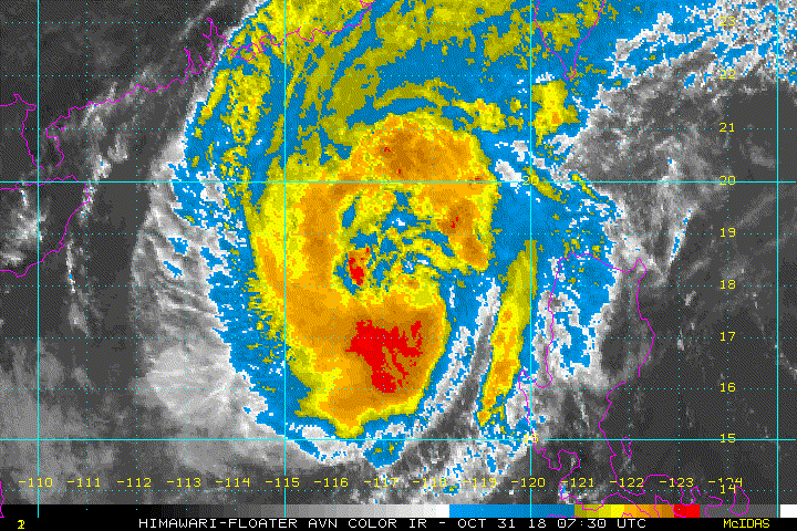
Looking a little more organized right now.
0 likes
Very useful information on the Dvorak Technique --
https://severe.worldweather.wmo.int/TCF ... kBeven.pdf
https://severe.worldweather.wmo.int/TCF ... kBeven.pdf
-
mrbagyo

- Category 5

- Posts: 3963
- Age: 33
- Joined: Thu Apr 12, 2012 9:18 am
- Location: 14.13N 120.98E
- Contact:
Re: WPAC: YUTU - Tropical Storm
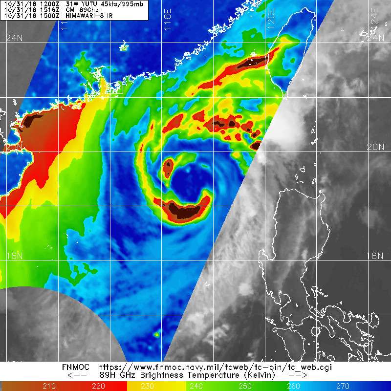
Getting a boost from trough interaction.
Looking pretty good
Looking pretty good
0 likes
The posts in this forum are NOT official forecast and should not be used as such. They are just the opinion of the poster and may or may not be backed by sound meteorological data. They are NOT endorsed by any professional institution or storm2k.org. For official information, please refer to RSMC, NHC and NWS products.
-
mrbagyo
- Category 5
- Posts: 3963
- Age: 33
- Joined: Thu Apr 12, 2012 9:18 am
- Location: 14.13N 120.98E
- Contact:
Re: WPAC: YUTU - Tropical Storm
0 likes
The posts in this forum are NOT official forecast and should not be used as such. They are just the opinion of the poster and may or may not be backed by sound meteorological data. They are NOT endorsed by any professional institution or storm2k.org. For official information, please refer to RSMC, NHC and NWS products.
-
1900hurricane

- Category 5
- Posts: 6063
- Age: 34
- Joined: Fri Feb 06, 2015 12:04 pm
- Location: Houston, TX
- Contact:
Re: WPAC: YUTU - Tropical Storm
Looks to be quickly dissipating now.
0 likes
Contract Meteorologist. TAMU & MSST. Fiercely authentic, one of a kind. We are all given free will, so choose a life meant to be lived. We are the Masters of our own Stories.
Opinions expressed are mine alone.
Follow me on Twitter at @1900hurricane : Read blogs at https://1900hurricane.wordpress.com/
Opinions expressed are mine alone.
Follow me on Twitter at @1900hurricane : Read blogs at https://1900hurricane.wordpress.com/
-
1900hurricane
- Category 5
- Posts: 6063
- Age: 34
- Joined: Fri Feb 06, 2015 12:04 pm
- Location: Houston, TX
- Contact:
Re: WPAC: YUTU - Tropical Storm
How the mighty have fallen.

2 likes
Contract Meteorologist. TAMU & MSST. Fiercely authentic, one of a kind. We are all given free will, so choose a life meant to be lived. We are the Masters of our own Stories.
Opinions expressed are mine alone.
Follow me on Twitter at @1900hurricane : Read blogs at https://1900hurricane.wordpress.com/
Opinions expressed are mine alone.
Follow me on Twitter at @1900hurricane : Read blogs at https://1900hurricane.wordpress.com/
-
doomhaMwx

- Category 5
- Posts: 2487
- Age: 27
- Joined: Tue Apr 18, 2017 4:01 am
- Location: Baguio/Benguet, Philippines
- Contact:
Re: WPAC: YUTU - Tropical Depression


TD
Issued at 06:45 UTC, 2 November 2018
<Analysis at 06 UTC, 2 November>
Scale -
Intensity -
TD
Center position N21°00' (21.0°)
E116°00' (116.0°)
Direction and speed of movement Almost stationary
Central pressure 1006 hPa
Issued at 06:45 UTC, 2 November 2018
<Analysis at 06 UTC, 2 November>
Scale -
Intensity -
TD
Center position N21°00' (21.0°)
E116°00' (116.0°)
Direction and speed of movement Almost stationary
Central pressure 1006 hPa
0 likes
-
1900hurricane
- Category 5
- Posts: 6063
- Age: 34
- Joined: Fri Feb 06, 2015 12:04 pm
- Location: Houston, TX
- Contact:
Re: WPAC: YUTU - Post-Tropical

0 likes
Contract Meteorologist. TAMU & MSST. Fiercely authentic, one of a kind. We are all given free will, so choose a life meant to be lived. We are the Masters of our own Stories.
Opinions expressed are mine alone.
Follow me on Twitter at @1900hurricane : Read blogs at https://1900hurricane.wordpress.com/
Opinions expressed are mine alone.
Follow me on Twitter at @1900hurricane : Read blogs at https://1900hurricane.wordpress.com/
-
1900hurricane
- Category 5
- Posts: 6063
- Age: 34
- Joined: Fri Feb 06, 2015 12:04 pm
- Location: Houston, TX
- Contact:
Re: WPAC: YUTU - Post-Tropical
0 likes
Contract Meteorologist. TAMU & MSST. Fiercely authentic, one of a kind. We are all given free will, so choose a life meant to be lived. We are the Masters of our own Stories.
Opinions expressed are mine alone.
Follow me on Twitter at @1900hurricane : Read blogs at https://1900hurricane.wordpress.com/
Opinions expressed are mine alone.
Follow me on Twitter at @1900hurricane : Read blogs at https://1900hurricane.wordpress.com/
-
euro6208
Re: WPAC: YUTU - Post-Tropical
Assessment found Super Typhoon Yutu brought gusts up to 200 mph
A more complete and detailed report on the findings of the Yutu Meteorological Assessment Team, along with additional pictures, figures and tables, will soon be posted on the WERI website at www.weriguam.org and on the WFO Guam website at www.weather.gov/GUM.
Yutu’s satellite intensity estimate peaked at 178 mph as a Category 5 storm just prior to landfall over Tinian and the southern half of Saipan, the assessment states. That value seems to establish the upper limit of the maximum intensity while over the islands.
All official ground-based instrumentation failed on Tinian and Saipan as the winds in the storm surged well-above 100 mph, the release states.
A more complete and detailed report on the findings of the Yutu Meteorological Assessment Team, along with additional pictures, figures and tables, will soon be posted on the WERI website at www.weriguam.org and on the WFO Guam website at www.weather.gov/GUM.
0 likes
-
CrazyC83
- Professional-Met

- Posts: 34315
- Joined: Tue Mar 07, 2006 11:57 pm
- Location: Deep South, for the first time!
Re: WPAC: YUTU - Post-Tropical
euro6208 wrote:Assessment found Super Typhoon Yutu brought gusts up to 200 mphYutu’s satellite intensity estimate peaked at 178 mph as a Category 5 storm just prior to landfall over Tinian and the southern half of Saipan, the assessment states. That value seems to establish the upper limit of the maximum intensity while over the islands.
All official ground-based instrumentation failed on Tinian and Saipan as the winds in the storm surged well-above 100 mph, the release states.
A more complete and detailed report on the findings of the Yutu Meteorological Assessment Team, along with additional pictures, figures and tables, will soon be posted on the WERI website at http://www.weriguam.org and on the WFO Guam website at http://www.weather.gov/GUM.
Did any pressure readings get captured? Without any other data, I would set the intensity at 150 kt.
0 likes
Re: WPAC: YUTU - Post-Tropical
Study: Yutu rivaled Karen
Lander was on Saipan during the passage of the typhoon and set up a rain gauge and a barometer at his location in San Vicente. All official ground-based instrumentation failed on Tinian and Saipan as the winds surged well above 100mph. The minimum pressure in San Vicente dropped to 921.7 millibars (mb), according to Lander’s findings.
After necessary adjustments, the pressure was used to estimate the minimum central surface pressure of Yutu, which was found to be somewhere in the range of 905-910 mb. His rain gauge recorded about 10 inches of rainfall during the storm, which was used to supplement the 2.66 inches of rainfall recorded up to midnight at the Francisco C. Ada/Saipan International Airport.
3 likes
Personal Forecast Disclaimer:
The posts in this forum are NOT official forecast and should not be used as such. They are just the opinion of the poster and may or may not be backed by sound meteorological data. They are NOT endorsed by any professional institution or storm2k.org. For official information, please refer to RSMC and NWS products.
The posts in this forum are NOT official forecast and should not be used as such. They are just the opinion of the poster and may or may not be backed by sound meteorological data. They are NOT endorsed by any professional institution or storm2k.org. For official information, please refer to RSMC and NWS products.
-
1900hurricane
- Category 5
- Posts: 6063
- Age: 34
- Joined: Fri Feb 06, 2015 12:04 pm
- Location: Houston, TX
- Contact:
Re: WPAC: YUTU - Post-Tropical
With that data, I'd probably keep peak intensity at 155 kt for Yutu. Using KZC and an estimated 905 mb pressure, I get about 150 kt using both JTWC and regressed JMA wind radii, and about 155 kt using JTWC's radius of the outermost closed isobar. Satellite estimates were also in the 155-160 kt range. 155 kt overlaps in both of these intensity estimate intervals as well as matches the operational estimate, so I see no reason to change it personally.
1 likes
Contract Meteorologist. TAMU & MSST. Fiercely authentic, one of a kind. We are all given free will, so choose a life meant to be lived. We are the Masters of our own Stories.
Opinions expressed are mine alone.
Follow me on Twitter at @1900hurricane : Read blogs at https://1900hurricane.wordpress.com/
Opinions expressed are mine alone.
Follow me on Twitter at @1900hurricane : Read blogs at https://1900hurricane.wordpress.com/
-
euro6208
Re: WPAC: YUTU - Post-Tropical
Downgraded to 150 knots.

0 likes
Very useful information on the Dvorak Technique --
https://severe.worldweather.wmo.int/TCF ... kBeven.pdf
https://severe.worldweather.wmo.int/TCF ... kBeven.pdf
Re: WPAC: YUTU - Typhoon
CrazyC83 wrote:Given the large size, I would have to suspect the pressure is below 900 mb right now. I would personally go with an intensity of 150 kt right now.
Strong bump/10, but this is actually what the revised JTWC best track went with XD.
0 likes
Very useful information on the Dvorak Technique --
https://severe.worldweather.wmo.int/TCF ... kBeven.pdf
https://severe.worldweather.wmo.int/TCF ... kBeven.pdf
Who is online
Users browsing this forum: No registered users and 74 guests