Florida Weather
Moderator: S2k Moderators
Forum rules

The posts in this forum are NOT official forecast and should not be used as such. They are just the opinion of the poster and may or may not be backed by sound meteorological data. They are NOT endorsed by any professional institution or STORM2K.
-
gatorcane

- S2K Supporter

- Posts: 23708
- Age: 48
- Joined: Sun Mar 13, 2005 3:54 pm
- Location: Boca Raton, FL
Re: Florida Weather
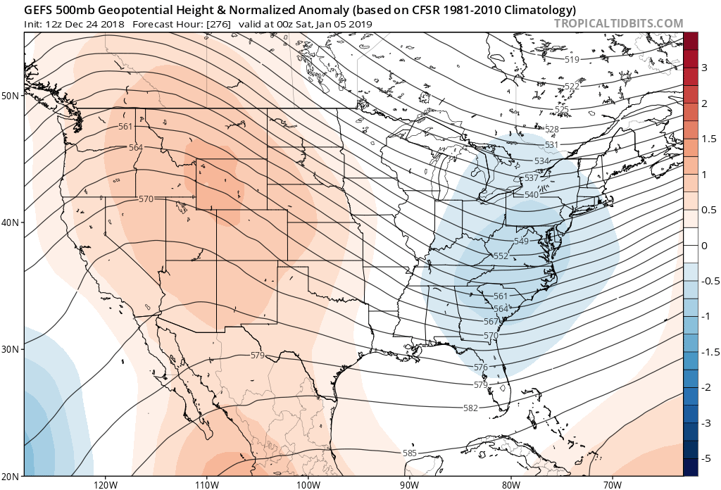
The GFS ensembles are depicting lowering of heights over the Eastern US in the long-range with a big ridge over the Western US. Still looking like a significant cool down for Florida come January and some of the model runs are bringing 850MB freezing temps down into Central Florida so this setup bears watching. Got a ways to go before we know exact details:
0 likes
Re: Florida Weather
Looks pretty warm and muggy (by December standards) after Christmas through New Year's. There's really not a cold blast in sight yet although the anomalous warmth we're about to experience should moderate to some extent.
1 likes
-
northjaxpro

- S2K Supporter
- Posts: 8900
- Joined: Mon Sep 27, 2010 11:21 am
- Location: Jacksonville, FL
Re: Florida Weather
Merry Christmas to all of my Storm2K family here across the peninsula!!!
Merry Christmas to everyone on the Storm2K forum!!
BTW, I hope you all are enjoying the mild weather we are having now and it will continue. across the peninsula through just past the New Year's holiday .
However, looking at the 06Z GFS FV3 run this morning, after January 2, the entire Eastern CONUS, including Florida, in all likelihood, will be under a full assault from Old Man Winter! He is coming big time by the middle and late portions of next week!
Also, I mentioned a few posts back on this thread about the potential of wintry precip next week as well over the Deep South. The prospects of that occuring also are gradually increasing as well. I have been following this closely as well on the Deep South Winter Thread.
1 likes
NEVER, EVER SAY NEVER in the tropics and weather in general, and most importantly, with life itself!!
________________________________________________________________________________________
Fay 2008 Beryl 2012 Debby 2012 Colin 2016 Hermine 2016 Julia 2016 Matthew 2016 Irma 2017 Dorian 2019
________________________________________________________________________________________
Fay 2008 Beryl 2012 Debby 2012 Colin 2016 Hermine 2016 Julia 2016 Matthew 2016 Irma 2017 Dorian 2019

Re: Florida Weather
Merry Christmas northjaxpro and everyone else. Yep, a nice stretch of warm wx will be in tap for the FL Peninsula through at least New Year's Day, just what the tourists ordered as they flock into our area during their winter break.
By this time last year we were starting to talk about the potential wintry wx across northern FL and southern GA in early January, which brought the first freeze to central FL, two nights in a row.
The GFS FV3 is the only outlier right now forecasting freezing temps for northern FL late next week, will watch if the Euro and old GFS comes along with it.
0 likes
-
northjaxpro
- S2K Supporter
- Posts: 8900
- Joined: Mon Sep 27, 2010 11:21 am
- Location: Jacksonville, FL
Re: Florida Weather
Yeah, the Southeast Georgia Winter Storm last January 3,, 2018 is among my great coups, if not the very best forecasting feat I have garnered here on Storm2K for sure. I snuffed that storm out 12 days in advance of that event. I had great fun tracking the evolution of that storm NDG and we both ended up road tripping that one as well to see the snow.
We may have another similar event in the Deep South next week as well. I am monitoring that closely..
Last edited by northjaxpro on Tue Dec 25, 2018 10:15 am, edited 1 time in total.
1 likes
NEVER, EVER SAY NEVER in the tropics and weather in general, and most importantly, with life itself!!
________________________________________________________________________________________
Fay 2008 Beryl 2012 Debby 2012 Colin 2016 Hermine 2016 Julia 2016 Matthew 2016 Irma 2017 Dorian 2019
________________________________________________________________________________________
Fay 2008 Beryl 2012 Debby 2012 Colin 2016 Hermine 2016 Julia 2016 Matthew 2016 Irma 2017 Dorian 2019
Re: Florida Weather
The GFS was the first to show the freezing temps across central FL, Euro had a big fail with the system in its medium range, the NAM did pretty good in the short range with the snow event.
0 likes
-
northjaxpro
- S2K Supporter
- Posts: 8900
- Joined: Mon Sep 27, 2010 11:21 am
- Location: Jacksonville, FL
Re: Florida Weather
NDG wrote::uarrow: I found the archive for the epic snow event starting on page 600, you did indeed sniffed it out even well ahead of the models'.
The GFS was the first to show the freezing temps across central FL, Euro had a big fail with the system in its medium range, the NAM did pretty good in the short range with the snow event.
Yeah, I really stuck my neck out big time then recognizing the strength of the +PNA, despite the + NAO, which had been in place up until late December last year. I stuck by the GFS when conventional wisdom and everyone else went with the EURO before the evolution of that event. It just so happened to pay off that occasion for me. I was just going on pure gut instincts on my part with regards for both the cold air outbreak and the Southeast Georgia storm. It indeed was fun this exact time last year for me forecasting that event NDG!
It is because of this event last year and also Hurricane Joaquin in 2015 as reasons I admit, as to my admiration to the GFS, especially in the winter months
Also, I agree NDG the NAM in the very short term did a great job with the Southeast Georgia Winter Storm as well. NAM is a very good winter time synoptics model in short term forecasting. I love analyzing that model for winter events. It also performed very well with the NC/VA. major winter storm back on Dec 8-10.
0 likes
NEVER, EVER SAY NEVER in the tropics and weather in general, and most importantly, with life itself!!
________________________________________________________________________________________
Fay 2008 Beryl 2012 Debby 2012 Colin 2016 Hermine 2016 Julia 2016 Matthew 2016 Irma 2017 Dorian 2019
________________________________________________________________________________________
Fay 2008 Beryl 2012 Debby 2012 Colin 2016 Hermine 2016 Julia 2016 Matthew 2016 Irma 2017 Dorian 2019
Re: Florida Weather
0 likes
-
northjaxpro
- S2K Supporter
- Posts: 8900
- Joined: Mon Sep 27, 2010 11:21 am
- Location: Jacksonville, FL
Re: Florida Weather
NDG wrote::uarrow: Yes, the GFS has been doing better while the Euro has been doing not so good at times. However, the Euro did an excellent job on Joaquin’s track once it was formed while the GFS was wrongly forecasting it to track towards the Carolinas causing all the panic.
Yes, the EURO track wise did well with Joaquin. This was another instance in which I went with my gut instinct with regards to development of Joaquin when no models showed any in the medium range from it being an ULL. However, if my memory serves me right, the GFS was the first major model at finally picking up on development of Joaquin from an ULL into a tropical cyclone, which of course, went on to become a deadly, major Cat 4 one at that!
1 likes
NEVER, EVER SAY NEVER in the tropics and weather in general, and most importantly, with life itself!!
________________________________________________________________________________________
Fay 2008 Beryl 2012 Debby 2012 Colin 2016 Hermine 2016 Julia 2016 Matthew 2016 Irma 2017 Dorian 2019
________________________________________________________________________________________
Fay 2008 Beryl 2012 Debby 2012 Colin 2016 Hermine 2016 Julia 2016 Matthew 2016 Irma 2017 Dorian 2019
-
gatorcane
- S2K Supporter
- Posts: 23708
- Age: 48
- Joined: Sun Mar 13, 2005 3:54 pm
- Location: Boca Raton, FL
Re: Florida Weather
Check out Pompano Beach Airpark last night which shows the moderating effect of the Gulf Stream. Temperature rose 7F between 3:53 and 4:53 in the morning as winds shifted to the NE:
25 04:53 NE 7 10.00 Mostly Cloudy BKN043 70 56 61% NA NA 30.14 1020.7
25 03:53 N 7 10.00 A Few Clouds FEW044 63 59 87% NA NA 30.14
https://w1.weather.gov/data/obhistory/KPMP.html
25 04:53 NE 7 10.00 Mostly Cloudy BKN043 70 56 61% NA NA 30.14 1020.7
25 03:53 N 7 10.00 A Few Clouds FEW044 63 59 87% NA NA 30.14
https://w1.weather.gov/data/obhistory/KPMP.html
0 likes
-
FlaWeatherDude

- Tropical Storm

- Posts: 115
- Age: 41
- Joined: Wed Oct 10, 2018 2:57 pm
- Location: Orlando, FL.
Re: Florida Weather
Tonights the last night central florida is in the 50's until after New Years Eve. Better enjoy it lol.
0 likes
"Windy has wings to fly above the clouds".
-
gatorcane
- S2K Supporter
- Posts: 23708
- Age: 48
- Joined: Sun Mar 13, 2005 3:54 pm
- Location: Boca Raton, FL
Re: Florida Weather
Wow the GFS has joined the other models and brings a really cold airmass into Florida in about 8-10 days. 
Still a long way to go and we by no means have any run to run consistency on this.
Still a long way to go and we by no means have any run to run consistency on this.
0 likes
-
TheStormExpert
Re: Florida Weather
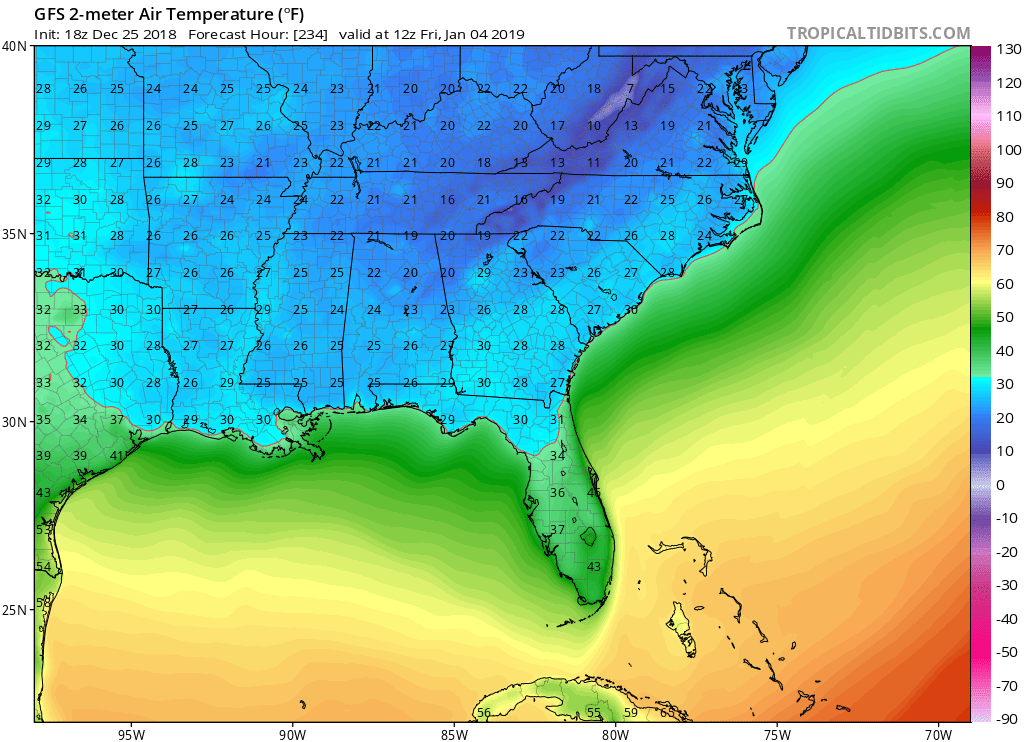
gatorcane wrote:Wow the GFS has joined the other models and brings a really cold airmass into Florida in about 8-10 days.
Still a long way to go and we by no means have any run to run consistency on this.
https://i.postimg.cc/nc4pdCKs/gfs-T2m-seus-40.png
Now we just need the Euro to jump onboard.
0 likes
Re: Florida Weather
The latest GFS V3 has dropped the freezing Arctic blast for FL late next week.
0 likes

Re: Florida Weather
Extended forecast seems to bring a front through in about 2 weeks, but appears to be barely significant with morning lows in the mid-upper 50s.
If you like cold January weather in South Florida, this is not what you want to read from NWS Miami:
"However, above 800 mb, the ridge of high pressure across the
Bahamas and greater Antilles mentioned earlier strengthens through
the weekend while it is centered closer to South Florida. In
fact, anomaly tables based on ensemble data indicate standardized
anomalies greater than 1-2.0 for heights above 850 mb across the
region through much of the period with pattern beginning to break
down towards middle of next week. This means that front moving
across southeast Friday and into the weekend never quite makes it
this far south as it bumps against this blocking high pressure
system."
0 likes
Re: Florida Weather
As the SSWE is happening the MJO is getting ready to amplify over phases 6 & 7 over the next 10 days or so which usually means a warm pattern for the eastern US, we may have to wait until it reaches phase 8 closer to the 14 day range.
0 likes
-
northjaxpro
- S2K Supporter
- Posts: 8900
- Joined: Mon Sep 27, 2010 11:21 am
- Location: Jacksonville, FL
Re: Florida Weather
Right now, the models are having difficulty locking into a solution with the pattern. I have since yesterday been perplexed by the changes I have seen with the models. I would not trust any model solution past 5 days right now.
We will eventually see a cold spell at some point across the peninsula within the next 10-14 days. It is just the questions of timing and magnitude of the cold in which hopefully the models will find some agreement about soon.
We will eventually see a cold spell at some point across the peninsula within the next 10-14 days. It is just the questions of timing and magnitude of the cold in which hopefully the models will find some agreement about soon.
0 likes
NEVER, EVER SAY NEVER in the tropics and weather in general, and most importantly, with life itself!!
________________________________________________________________________________________
Fay 2008 Beryl 2012 Debby 2012 Colin 2016 Hermine 2016 Julia 2016 Matthew 2016 Irma 2017 Dorian 2019
________________________________________________________________________________________
Fay 2008 Beryl 2012 Debby 2012 Colin 2016 Hermine 2016 Julia 2016 Matthew 2016 Irma 2017 Dorian 2019
-
SFLcane

- S2K Supporter
- Posts: 10281
- Age: 48
- Joined: Sat Jun 05, 2010 1:44 pm
- Location: Lake Worth Florida
Re: Florida Weather
NDG wrote:The latest GFS V3 has dropped the freezing Arctic blast for FL late next week.
Of course it did horrible model...
0 likes
Re: Florida Weather
When the only evidence of cold is GFS fantasy runs...it probably isn't happening. If there's no deep cold across the north there's no ammo in the cannon. CPC has normalish temps over the southeast on their latest 8-14 day depiction so some cooldown is on the table but unless and until we see some cold entering the northland I'd be disregarding any GFS cold blasts. If anything the flow looks persistently zonal...not a good set up to bring cold this way...yet..
0 likes
-
northjaxpro
- S2K Supporter
- Posts: 8900
- Joined: Mon Sep 27, 2010 11:21 am
- Location: Jacksonville, FL
Re: Florida Weather
There is enough agreement with the models going out at least through 168 hours, that a rather stout upper ridge for early January, will push a warm front well north of the peninsula by Monday afternoon.
Both Monday and New Year's Day will be unseasonably warm, as well as Wednesday of next week across the state. The southerly flow takes hold across the areai out ahead of the cold front most of next week.
.
The front will push back slowly to the south on Wednesday and Thursday of next week toward Florida., Rain will also move back in across North Florida along and just ahead of the cold front. The front will pass through North Florida Wednesday evening, or early Thursday morning, and later finally push down through the rest of the peninsula by next Friday. (Jan 4)
It will cool down appreciably behind this front next week, but nothing extremely drastic temperature-wise.
0 likes
NEVER, EVER SAY NEVER in the tropics and weather in general, and most importantly, with life itself!!
________________________________________________________________________________________
Fay 2008 Beryl 2012 Debby 2012 Colin 2016 Hermine 2016 Julia 2016 Matthew 2016 Irma 2017 Dorian 2019
________________________________________________________________________________________
Fay 2008 Beryl 2012 Debby 2012 Colin 2016 Hermine 2016 Julia 2016 Matthew 2016 Irma 2017 Dorian 2019
Return to “USA & Caribbean Weather”
Who is online
Users browsing this forum: wxman22, Yukon Cornelius and 119 guests