2019 Indicators: SST'S / Sal / MSLP / Steering / Shear / Instability (See updated graphics at first post)
Moderator: S2k Moderators
Forum rules

The posts in this forum are NOT official forecasts and should not be used as such. They are just the opinion of the poster and may or may not be backed by sound meteorological data. They are NOT endorsed by any professional institution or STORM2K. For official information, please refer to products from the National Hurricane Center and National Weather Service.
-
SconnieCane
- Category 5

- Posts: 1013
- Joined: Thu Aug 02, 2018 5:29 pm
- Location: Madison, WI
Re: 2019 Indicators: SST'S / Sal / MSLP / Steering / Shear / Instability (See updated graphics at first post)
1 likes
-
CyclonicFury

- Category 5
- Posts: 2038
- Age: 27
- Joined: Sun Jul 02, 2017 12:32 pm
- Location: NC
- Contact:
Re: 2019 Indicators: SST'S / Sal / MSLP / Steering / Shear / Instability (See updated graphics at first post)
cycloneye wrote:ECMWF Febuary update of MSLP for June,July and August.
https://i.imgur.com/v7SZsDv.png
When was the last time ECMWF showed below normal pressures over the Atlantic during the season? I'm pretty sure it has shown above average pressures every year since 2014. However it has a higher chance of verifying this year due to the possibility of El Niño.
5 likes
NCSU B.S. in Meteorology Class of 2021. Tropical weather blogger at http://www.cyclonicfury.com. My forecasts and thoughts are NOT official, for official forecasts please consult the National Hurricane Center.
-
Kingarabian

- S2K Supporter

- Posts: 16379
- Joined: Sat Aug 08, 2009 3:06 am
- Location: Honolulu, Hawaii
Re: 2019 Indicators: SST'S / Sal / MSLP / Steering / Shear / Instability (See updated graphics at first post)
cycloneye wrote:ECMWF Febuary update of MSLP for June,July and August.
https://i.imgur.com/v7SZsDv.png
Damn, looks pretty bad for me.
1 likes
RIP Kobe Bryant
-
NotSparta

- Professional-Met

- Posts: 1677
- Age: 24
- Joined: Fri Aug 18, 2017 8:24 am
- Location: Naples, FL
- Contact:
Re: 2019 Indicators: SST'S / Sal / MSLP / Steering / Shear / Instability (See updated graphics at first post)
Kingarabian wrote:cycloneye wrote:ECMWF Febuary update of MSLP for June,July and August.
https://i.imgur.com/v7SZsDv.png
Damn, looks pretty bad for me.
As is the usual for euro output
4 likes
This post was probably an opinion of mine, and in no way is official. Please refer to http://www.hurricanes.gov for official tropical analysis and advisories.
My website, with lots of tropical wx graphics, including satellite and recon: http://cyclonicwx.com
My website, with lots of tropical wx graphics, including satellite and recon: http://cyclonicwx.com
-
Kingarabian
- S2K Supporter
- Posts: 16379
- Joined: Sat Aug 08, 2009 3:06 am
- Location: Honolulu, Hawaii
-
Hypercane_Kyle

- Category 5
- Posts: 3465
- Joined: Sat Mar 07, 2015 7:58 pm
- Location: Cape Canaveral, FL
Re: 2019 Indicators: SST'S / Sal / MSLP / Steering / Shear / Instability (See updated graphics at first post)
ECMWF pretty much says that every year and is usually wrong, to be honest.
7 likes
My posts are my own personal opinion, defer to the National Hurricane Center (NHC) and other NOAA products for decision making during hurricane season.
-
AxaltaRacing24
- Category 5
- Posts: 1774
- Age: 25
- Joined: Wed Jul 27, 2016 11:14 am
- Location: Jupiter, FL
Re: 2019 Indicators: SST'S / Sal / MSLP / Steering / Shear / Instability (See updated graphics at first post)
Different year, same forecast.
5 likes
-
cycloneye

- Admin

- Posts: 149715
- Age: 69
- Joined: Thu Oct 10, 2002 10:54 am
- Location: San Juan, Puerto Rico
Re: 2019 Indicators: SST'S / Sal / MSLP / Steering / Shear / Instability (See updated graphics at first post)
Great discussions here.
https://twitter.com/EricBlake12/status/1098199212880203778
https://twitter.com/EricBlake12/status/1098201914896990209
https://twitter.com/TropicalTidbits/status/1098211597586182144
https://twitter.com/EricBlake12/status/1098213406795010048
https://twitter.com/cyclonicwx/status/1098212933857959936
https://twitter.com/AndyHazelton/status/1098215086450188288
https://twitter.com/EricBlake12/status/1098215580904144898
https://twitter.com/MichaelRLowry/status/1098275537179545602
https://twitter.com/EricBlake12/status/1098275757015601152
2 likes
Visit the Caribbean-Central America Weather Thread where you can find at first post web cams,radars
and observations from Caribbean basin members Click Here
and observations from Caribbean basin members Click Here
-
Hypercane_Kyle
- Category 5
- Posts: 3465
- Joined: Sat Mar 07, 2015 7:58 pm
- Location: Cape Canaveral, FL
Re: 2019 Indicators: SST'S / Sal / MSLP / Steering / Shear / Instability (See updated graphics at first post)
A simple glance at Nino 3.4 current trends and the NMME 3.4 model forecasts are enough to tell one how badly they're already doing at predicting the ENSO this year. Nino 3.4 would have to do a hard turn indeed right now to match any of the predicted model outputs. I think this year will be dead on neutral.
1 likes
My posts are my own personal opinion, defer to the National Hurricane Center (NHC) and other NOAA products for decision making during hurricane season.
-
cycloneye
- Admin
- Posts: 149715
- Age: 69
- Joined: Thu Oct 10, 2002 10:54 am
- Location: San Juan, Puerto Rico
Re: 2019 Indicators: SST'S / Sal / MSLP / Steering / Shear / Instability (See updated graphics at first post)
The warm uptick of the past few weeks in MDR are litterally over for now.


2 likes
Visit the Caribbean-Central America Weather Thread where you can find at first post web cams,radars
and observations from Caribbean basin members Click Here
and observations from Caribbean basin members Click Here
-
hurricanetrack

- HurricaneTrack.com
- Posts: 1781
- Joined: Tue Dec 02, 2003 10:46 pm
- Location: Wilmington, NC
- Contact:
Re: 2019 Indicators: SST'S / Sal / MSLP / Steering / Shear / Instability (See updated graphics at first post)
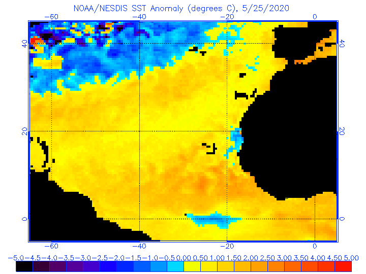
Strange how the CDAS looks nothing like the Noaa/NESDIS SST anomaly map. Huge difference here.
1 likes
-
CyclonicFury
- Category 5
- Posts: 2038
- Age: 27
- Joined: Sun Jul 02, 2017 12:32 pm
- Location: NC
- Contact:
Re: 2019 Indicators: SST'S / Sal / MSLP / Steering / Shear / Instability (See updated graphics at first post)
hurricanetrack wrote:https://www.ospo.noaa.gov/data/sst/anomaly/anomwne.gif
Strange how the CDAS looks nothing like the Noaa/NESDIS SST anomaly map. Huge difference here.
The NOAA/NESDIS map is warm biased because I think it uses a base period during the 1980s/early 1990s for its anomaly. However, the CDAS charts on Tropical Tidbits are noisy/prone to sharp changes and the sharp SSTA drop in the Atlantic MDR may just be temporary.
1 likes
NCSU B.S. in Meteorology Class of 2021. Tropical weather blogger at http://www.cyclonicfury.com. My forecasts and thoughts are NOT official, for official forecasts please consult the National Hurricane Center.
-
StruThiO

- Category 3

- Posts: 821
- Age: 26
- Joined: Fri Sep 15, 2017 5:51 am
- Location: Currently Portland, OR. Raised in Jax, FL.
Re: 2019 Indicators: SST'S / Sal / MSLP / Steering / Shear / Instability (See updated graphics at first post)
CyclonicFury wrote:
Strange how the CDAS looks nothing like the Noaa/NESDIS SST anomaly map. Huge difference here.
The NOAA/NESDIS map is warm biased because I think it uses a base period during the 1980s/early 1990s for its anomaly. However, the CDAS charts on Tropical Tidbits are noisy/prone to sharp changes and the sharp SSTA drop in the Atlantic MDR may just be temporary.
Wasn't there a SAL outbreak earlier this February? Perhaps that could be causing the noisy signal
0 likes
-
cycloneye
- Admin
- Posts: 149715
- Age: 69
- Joined: Thu Oct 10, 2002 10:54 am
- Location: San Juan, Puerto Rico
Re: 2019 Indicators: SST'S / Sal / MSLP / Steering / Shear / Instability (See updated graphics at first post)
StruThiO wrote:CyclonicFury wrote:
Strange how the CDAS looks nothing like the Noaa/NESDIS SST anomaly map. Huge difference here.
The NOAA/NESDIS map is warm biased because I think it uses a base period during the 1980s/early 1990s for its anomaly. However, the CDAS charts on Tropical Tidbits are noisy/prone to sharp changes and the sharp SSTA drop in the Atlantic MDR may just be temporary.
Wasn't there a SAL outbreak earlier this February? Perhaps that could be causing the noisy signal
Right now there is a good deal of SAL in MDR if you look at the graphic at first post.
2 likes
Visit the Caribbean-Central America Weather Thread where you can find at first post web cams,radars
and observations from Caribbean basin members Click Here
and observations from Caribbean basin members Click Here
-
NotSparta
- Professional-Met
- Posts: 1677
- Age: 24
- Joined: Fri Aug 18, 2017 8:24 am
- Location: Naples, FL
- Contact:
Re: 2019 Indicators: SST'S / Sal / MSLP / Steering / Shear / Instability (See updated graphics at first post)
cycloneye wrote:StruThiO wrote:CyclonicFury wrote:
Strange how the CDAS looks nothing like the Noaa/NESDIS SST anomaly map. Huge difference here.
The NOAA/NESDIS map is warm biased because I think it uses a base period during the 1980s/early 1990s for its anomaly. However, the CDAS charts on Tropical Tidbits are noisy/prone to sharp changes and the sharp SSTA drop in the Atlantic MDR may just be temporary.
Wasn't there a SAL outbreak earlier this February? Perhaps that could be causing the noisy signal
Right now there is a good deal of SAL in MDR if you look at the graphic at first post.
Since CDAS (& OISSTv2) use satellite estimates, they will show lower SSTs than actual, due to the aerosols in the air. However the NOAA/NESDIS maps are still biased warm
0 likes
This post was probably an opinion of mine, and in no way is official. Please refer to http://www.hurricanes.gov for official tropical analysis and advisories.
My website, with lots of tropical wx graphics, including satellite and recon: http://cyclonicwx.com
My website, with lots of tropical wx graphics, including satellite and recon: http://cyclonicwx.com

Re: 2019 Indicators: SST'S / Sal / MSLP / Steering / Shear / Instability (See updated graphics at first post)
Hey Luis, just a thought. Any consideration to open up the Annual 2019 Atlantic Season Activity Prediction contest earlier this year? Just throwing in my own vote for it given our eventual increase in discussion about the so many forecast and changing factors (ENSO, SAL, SST's, wind patterns, African rainfall, etc) as we move deeper into Spring and start eye-balling June 1st. Also, seems that we've lately seen an increase in sub-tropical development to the point that nothing would totally surprise me in terms of early baroclinic transformative development in some point within the Atlantic basin.
1 likes
Andy D
(For official information, please refer to the NHC and NWS products.)
(For official information, please refer to the NHC and NWS products.)
-
cycloneye
- Admin
- Posts: 149715
- Age: 69
- Joined: Thu Oct 10, 2002 10:54 am
- Location: San Juan, Puerto Rico
Re: 2019 Indicators: SST'S / Sal / MSLP / Steering / Shear / Instability (See updated graphics at first post)
chaser1 wrote:Hey Luis, just a thought. Any consideration to open up the Annual 2019 Atlantic Season Activity Prediction contest earlier this year? Just throwing in my own vote for it given our eventual increase in discussion about the so many forecast and changing factors (ENSO, SAL, SST's, wind patterns, African rainfall, etc) as we move deeper into Spring and start eye-balling June 1st. Also, seems that we've lately seen an increase in sub-tropical development to the point that nothing would totally surprise me in terms of early baroclinic transformative development in some point within the Atlantic basin.
Announcement: I will start the 2019 S2K poll on April 15 instead of May 1.
5 likes
Visit the Caribbean-Central America Weather Thread where you can find at first post web cams,radars
and observations from Caribbean basin members Click Here
and observations from Caribbean basin members Click Here
-
cycloneye
- Admin
- Posts: 149715
- Age: 69
- Joined: Thu Oct 10, 2002 10:54 am
- Location: San Juan, Puerto Rico
Re: 2019 Indicators: SST'S / Sal / MSLP / Steering / Shear / Instability (See updated graphics at first post)
0 likes
Visit the Caribbean-Central America Weather Thread where you can find at first post web cams,radars
and observations from Caribbean basin members Click Here
and observations from Caribbean basin members Click Here
-
TheStormExpert
Re: 2019 Indicators: SST'S / Sal / MSLP / Steering / Shear / Instability (See updated graphics at first post)
cycloneye wrote:https://twitter.com/MJVentrice/status/1104393404153319424
Where about in the North Atlantic? Tropics or Subtropics? Either way it would mean little to no difference likely in the outcome of things if you have a full blown El Niño like some are saying may come to fruition.
0 likes
-
CyclonicFury
- Category 5
- Posts: 2038
- Age: 27
- Joined: Sun Jul 02, 2017 12:32 pm
- Location: NC
- Contact:
Re: 2019 Indicators: SST'S / Sal / MSLP / Steering / Shear / Instability (See updated graphics at first post)
TheStormExpert wrote:cycloneye wrote:https://twitter.com/MJVentrice/status/1104393404153319424
Where about in the North Atlantic? Tropics or Subtropics? Either way it would mean little to no difference likely in the outcome of things if you have a full blown El Niño like some are saying may come to fruition.
I think even in a moderate-strong El Niño, a warm MDR would likely make the difference between a well below average season and a slightly below average season. Look at 2015 for this. The MDR was fairly active that season including a major hurricane. As long as the WAM remains strong as it has been in recent years, I don't think we will be looking at historic inactivity this season even if we have a strong El Niño.
2 likes
NCSU B.S. in Meteorology Class of 2021. Tropical weather blogger at http://www.cyclonicfury.com. My forecasts and thoughts are NOT official, for official forecasts please consult the National Hurricane Center.
Who is online
Users browsing this forum: No registered users and 200 guests