Invest 90Q
TXST21 KNES 240002
TCSSTL
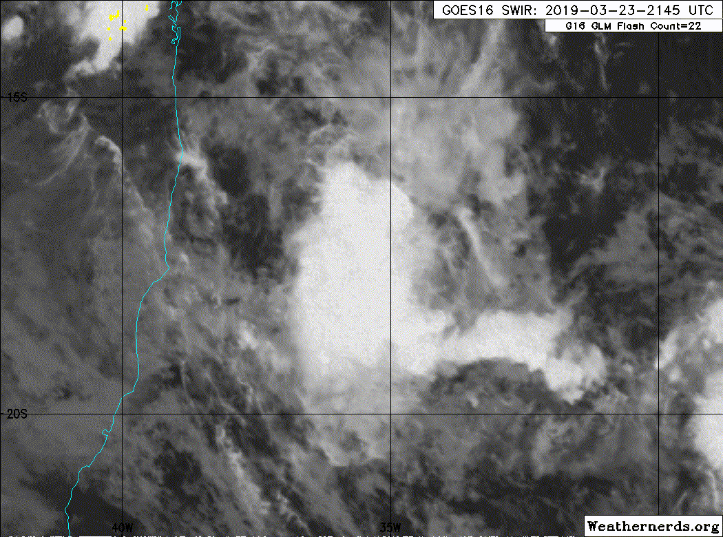
A. TROPICAL DISTURBANCE (90Q)
B. 23/2330Z
C. 17.6S
D. 36.0W
E. THREE/GOES-E
F. T1.0/1.0/D1.0/24HRS
G. IR/EIR/SWIR
H. REMARKS...WANING VISIBLE IMAGERY SHOWED A WELL-DEFINED LOW
LEVEL CIRCULATION WITH DEVELOPING CONVECTION OVER AND EAST OF THE
CENTER. CONVECTION HAS FLUCTUATED SOME SINCE THEN BUT MEASURES SLIGHTLY
MORE THAN 2/10 FOR A DT OF 1.0. MET AND PT ARE ALSO 1.0. FT IS BASED
ON DT.
I. ADDL POSITIONS
NIL
...TURK
SATL - IBA - Post-Tropical
Moderator: S2k Moderators
-
Nancy Smar

- Category 5

- Posts: 1081
- Age: 25
- Joined: Wed Aug 16, 2017 10:03 pm
SATL - IBA - Post-Tropical
2 likes
-
Sciencerocks
- Category 5
- Posts: 10194
- Age: 40
- Joined: Thu Jul 06, 2017 1:51 am
Re: SATL - Tropical Depression/INVEST 90Q
Looks like a depression
1. Well defined LLC
2. convection
I'd expect it to strengthen into a tropical storm tonight and peak around 50-55 knots.
1. Well defined LLC
2. convection
I'd expect it to strengthen into a tropical storm tonight and peak around 50-55 knots.
1 likes
-
Sciencerocks
- Category 5
- Posts: 10194
- Age: 40
- Joined: Thu Jul 06, 2017 1:51 am
-
TheAustinMan

- Category 5
- Posts: 1060
- Joined: Mon Jul 08, 2013 4:26 pm
- Location: Central TX / United States
Re: SATL - Tropical Depression/INVEST 90Q
A ScatSat pass at 22:30Z showed quality-controlled winds of 30 knots, with the strongest winds in the southeastern semicircle. Within the more uncertain convection there are higher sampled winds of 35 to 40 knots, though these have been automatically flagged as being more uncertain data points.
254 kB. Source: KNMI

254 kB. Source: KNMI
2 likes
Treat my opinions with a grain of salt. For official information see your local weather service.
“It's tough to make predictions, especially about the future.”
“It's tough to make predictions, especially about the future.”
-
CyclonicFury

- Category 5
- Posts: 2040
- Age: 27
- Joined: Sun Jul 02, 2017 12:32 pm
- Location: NC
- Contact:
Re: SATL - Tropical Depression/INVEST 90Q
Wow. The latest GFS is very aggressive with 90Q, bringing it to near hurricane strength.

The sounding shows a deep warm core, with a minimum pressure of 988 mb and maximum sustained winds of at least 55 kt. This is not your ordinary borderline SATL system.
The sounding shows a deep warm core, with a minimum pressure of 988 mb and maximum sustained winds of at least 55 kt. This is not your ordinary borderline SATL system.
1 likes
NCSU B.S. in Meteorology Class of 2021. Tropical weather blogger at http://www.cyclonicfury.com. My forecasts and thoughts are NOT official, for official forecasts please consult the National Hurricane Center.
-
Vince_and_Grace_fan

- Category 1

- Posts: 328
- Joined: Thu Nov 03, 2016 9:25 am
- Location: Szombathely (Hungary)

-
StruThiO

- Category 3

- Posts: 821
- Age: 26
- Joined: Fri Sep 15, 2017 5:51 am
- Location: Currently Portland, OR. Raised in Jax, FL.
Re: SATL - Tropical Depression/INVEST 90Q
This thing has great outflow. A hurricane is definitely possible, in my opinion.
0 likes
-
Sciencerocks
- Category 5
- Posts: 10194
- Age: 40
- Joined: Thu Jul 06, 2017 1:51 am
Re: SATL - Tropical Depression/INVEST 90Q
This is probably close to tropical storm strength within my opinion.
1 likes
-
TheAustinMan
- Category 5
- Posts: 1060
- Joined: Mon Jul 08, 2013 4:26 pm
- Location: Central TX / United States
Re: SATL - Tropical Depression/INVEST 90Q
The system has developed into a classical curved band structure with good outflow both equatorward and poleward supported by a well-positioned anticyclone aloft. At this point, I think it's clear we're looking at a bona fide tropical cyclone in the South Atlantic. The local environment remains favorable for intensification and we may see continued improvement throughout the day under modest wind shear (5-15 kt) and warm sea surface temperatures above 28C.
812 KB. Source: SSEC RealEarth

812 KB. Source: SSEC RealEarth
3 likes
Treat my opinions with a grain of salt. For official information see your local weather service.
“It's tough to make predictions, especially about the future.”
“It's tough to make predictions, especially about the future.”
-
Vince_and_Grace_fan
- Category 1
- Posts: 328
- Joined: Thu Nov 03, 2016 9:25 am
- Location: Szombathely (Hungary)
Re: SATL - Tropical Depression/INVEST 90Q
ASCAT found 35 kt wind vectors under the southeastern convective blob so it is a weak TS now, but the circulation is still a bit elongated as visible satellite images also suggest.

1 likes
-
Hypercane_Kyle

- Category 5
- Posts: 3465
- Joined: Sat Mar 07, 2015 7:58 pm
- Location: Cape Canaveral, FL
Re: SATL - Tropical Depression/INVEST 90Q
Looks 100% tropical. GFS takes it down to 993mb. Probably one of the most well-organized tropical cyclones in the Southern Atlantic. If it keeps up we could be looking at the 2nd ever recorded hurricane in the SATL.

1 likes
My posts are my own personal opinion, defer to the National Hurricane Center (NHC) and other NOAA products for decision making during hurricane season.
-
TheAustinMan
- Category 5
- Posts: 1060
- Joined: Mon Jul 08, 2013 4:26 pm
- Location: Central TX / United States
Re: SATL - IBA - Tropical Storm
At 16 UTC, the Brazilian Navy (the de facto agency for the South Atlantic) declared the system to be a tropical storm with winds of 35 kt and central pressure of 1008 mb, designating it with the name Iba. The system remains a disturbance in NHC/JTWC ATCF.
WARNING NR 208/2019
SPECIAL WARNING
ISSUED AT 1600 UTC - SUN - 24/MAR/2019
TROPICAL STORM "IBA" WITH ESTIMATED CENTRAL PRESSURE OF 1008 HPA AT 18.5S036W AND ESTIMATED MAXIMUM WINDS 35 KT. FORECAST: WIND SE/NE FORCE 7/9 (28-47 KNOTS) WITH GUSTS IN THE EAST SECTOR OF THE SYSTEM AND WIND SW/S FORCE 7 (28-33 KNOTS) NEAR THE COAST OVER AREA ECHO SOUTH OF 16S AND OVER AREA DELTA NORTH OF 23S.
ESTIMATED POSITION:
241800 UTC: 18.5S036.5W - 1008 HPA – ESTIMATED MAXIMUM SUSTAINED WIND 30-35 KNOTS - TROPICAL STORM
250000 UTC: 19S036.5W - 1008 HPA – ESTIMATED MAXIMUM SUSTAINED WIND 35-40 KNOTS - TROPICAL STORM
250600 UTC: 19S037W - 1008 HPA – ESTIMATED MAXIMUM SUSTAINED WIND 40-45 KNOTS - TROPICAL STORM
251200 UTC: 19.5S037W - 1008 HPA – ESTIMATED MAXIMUM SUSTAINED WIND 40-45 KNOTS - TROPICAL STORM
THIS WARNING REPLACES THE WARNING NR 205/2019.
2 likes
Treat my opinions with a grain of salt. For official information see your local weather service.
“It's tough to make predictions, especially about the future.”
“It's tough to make predictions, especially about the future.”
-
CyclonicFury
- Category 5
- Posts: 2040
- Age: 27
- Joined: Sun Jul 02, 2017 12:32 pm
- Location: NC
- Contact:
Re: SATL - IBA - Tropical Storm
JTWC/NHC still have it as 90Q, but this is the first SATL Tropical Storm since 2010!
1 likes
NCSU B.S. in Meteorology Class of 2021. Tropical weather blogger at http://www.cyclonicfury.com. My forecasts and thoughts are NOT official, for official forecasts please consult the National Hurricane Center.


Re: SATL - IBA - Tropical Storm
A disturbance to the NW of Iba also has a nice spin, better visible on a loop

0 likes
-
jaguarjace

- Category 4

- Posts: 975
- Age: 31
- Joined: Sat Jun 11, 2011 7:38 am
- Location: Khon Kaen, Thailand
Re: SATL - IBA - Tropical Storm

1 likes
Owner of the Tropical Archive YouTube channel
Web Developer at Force Thirteen
Twitter/X : @force13_support
Web Developer at Force Thirteen
Twitter/X : @force13_support
-
AJC3

- Admin

- Posts: 4156
- Age: 62
- Joined: Tue Aug 31, 2004 7:04 pm
- Location: Ballston Spa, New York
- Contact:
Re: SATL - IBA - Tropical Storm
It's odd to see them use a frontal cyclone model for Iba in the surface analysis. They're must be used to placing fronts on any type of low.
2 likes
-
Dave C
- S2K Supporter

- Posts: 868
- Joined: Thu Sep 04, 2003 4:36 pm
- Location: Middleboro, Mass.(midway between Cape Cod and Boston)
Re: SATL - IBA - Tropical Storm
AJC3 wrote:It's odd to see them use a frontal cyclone model for Iba in the surface analysis. They're must be used to placing fronts on any type of low.
Actually the system with the fronts is to the south, it confused me too.Iba is north of there at 20 latitude
1 likes
-
AJC3
- Admin
- Posts: 4156
- Age: 62
- Joined: Tue Aug 31, 2004 7:04 pm
- Location: Ballston Spa, New York
- Contact:
Re: SATL - IBA - Tropical Storm
Dave C wrote:AJC3 wrote:It's odd to see them use a frontal cyclone model for Iba in the surface analysis. They're must be used to placing fronts on any type of low.
Actually the system with the fronts is to the south, it confused me too.Iba is north of there at 20 latitude
I only missed it by 22 degrees and two lows!
3 likes
-
Dave C
- S2K Supporter
- Posts: 868
- Joined: Thu Sep 04, 2003 4:36 pm
- Location: Middleboro, Mass.(midway between Cape Cod and Boston)
Re: SATL - IBA - Tropical Storm
AJC3 wrote:Dave C wrote:AJC3 wrote:It's odd to see them use a frontal cyclone model for Iba in the surface analysis. They're must be used to placing fronts on any type of low.
Actually the system with the fronts is to the south, it confused me too.Iba is north of there at 20 latitude
I only missed it by 22 degrees and two lows!


South America is a long continent, easy to get lost.
0 likes
-
tolakram
- Admin
- Posts: 20189
- Age: 62
- Joined: Sun Aug 27, 2006 8:23 pm
- Location: Florence, KY (name is Mark)
Re: SATL - IBA - Tropical Storm
1 likes
M a r k
- - - - -
Join us in chat: Storm2K Chatroom Invite. Android and IOS apps also available.
The posts in this forum are NOT official forecasts and should not be used as such. Posts are NOT endorsed by any professional institution or STORM2K.org. For official information and forecasts, please refer to NHC and NWS products.
Who is online
Users browsing this forum: No registered users and 60 guests