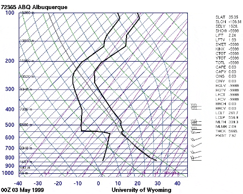
Perhaps the best example of EML is actually from May 1999. In my loop below, the first sounding is from the early evening of May 2nd in Albuquerque, NM. Note the steep lapse rates from the very well mixed boundary layer. The next image follows the wind barbs in the EML east to Amarillo. This sounding is from the morning of the next day, May 3rd. A cooler morning temperature with a higher dewpoint can be seen at the surface, but the EML just above that remains very well intact. The last image in the loop continues further east, from Norman that same evening. A warm moist layer can be seen below the EML, and in the presence of a convective trigger (in this case a dryline), some storms did manage to explosively develop. In fact, the weather balloon for this sounding was probably struck down by lightning in the anvil of a supercell approaching the Oklahoma City area while producing an F5 tornado. The main takeaway is that across all three soundings, the EML between 600-800 mb remains very well preserved.