#913 Postby weatherdude1108 » Tue Apr 23, 2019 4:19 pm
EWX discussion:
Area Forecast Discussion
National Weather Service Austin/San Antonio TX
354 PM CDT Tue Apr 23 2019
.SHORT TERM (Tonight through Wednesday Night)...
An active short term forecast is expected for South Central Texas.
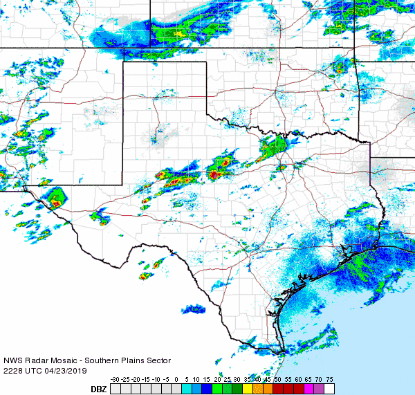
For tonight, Severe Thunderstorm Watch 95 is in effect for Val Verde
County through 11 PM CDT. Visible satellite imagery has shown nearly
persistent cloud cover across Val Verde County through the day, which
has helped limit overall destabilization, but nearly full insolation
along the Serranias del Burro have resulted in an agitated cumulus
field with the DRT radar showing developing showers. SPC Mesoanalysis
shows over 50 knots of southwesterly effective bulk shear,
encouraging additional thunderstorm organization. As these
thunderstorms become more organized, convection allowing models
indicate that these storms will make a run for the Rio Grande later
this evening. Despite the cloud cover, dew points in the upper 60s
are contributing to SBCAPEs in excess of 2500 J/kg which will help
storms maintain themselves as they approach the Rio Grande. This
will also allow them to advantage of steeper mid-level lapse rates
of 7 C/km and encourage a large hail threat for parts of Val Verde.
Farther north, convection continues to fire along a frontal boundary
draped roughly along Interstate 20. Higher resolution guidance has
been fairly consistent in advertising strong enough cold pool
development with these thunderstorms that the cold front may actually
be driven farther south than global guidance indicates by sunrise
(into Central Texas/the Hill Country). Should this happen, this will
set up the potential for training showers and thunderstorms as
increasing forcing from an upper low diving across Chihuahua tonight
into the Big Bend arrives. For the remainder of tonight, expect most
of the shower and thunderstorm activity to remain relegated to the
northern tier of counties with rainfall amounts up to one inch
possible.
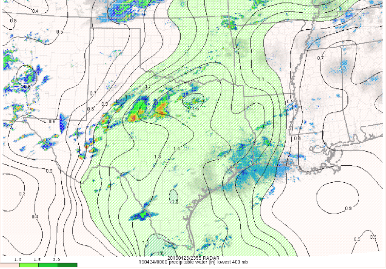
During the day Wednesday, the location of the aforementioned frontal
boundary will have huge implications for which areas see the heaviest
rainfall but expect the frontal boundary to be near the northern
border of the forecast area. The approach of the upper low will allow
for the left front quadrant of an upper level jet to nose into
Central Texas. While the initial approach of this upper level jet is
expected to be during the morning hours (usually the most stable time
of the day), increasing divergence aloft will help to accelerate rain
rates across portions of Central Texas and the Hill Country. With
forecast precipitable water values rising to near 1.5 inches,
enhanced lift, and a slow-moving frontal boundary, have concerns that
a localized flash flood threat may materialize for parts of the
eastern Hill Country into Central Texas and have issued a Flash Flood
Watch through the day Wednesday as a result. Current expectations
for rainfall amounts in the watch area are in the 2 to 4 inch range,
but isolated higher amounts in the 4 to 6 inch range appear possible
based on ensemble plumes and high resolution QPF output. Based on
these forecast amounts, rises to at least action stage on rivers and
creeks are also possible during the day Wednesday.
Despite persistent cloud cover during the day, at least some
destabilization during the peak of the diurnal cycle and strong
forcing for ascent will allow for some thunderstorm intensification
during the afternoon hours. Cannot rule out some large hail, but
expect gusty winds to be the main concern with freezing levels above
12,000 feet AGL and updrafts becoming water loaded as the
thunderstorms translate east. Backed surface flow in the vicinity of
the cold front may also create for an isolated tornado threat.
Analysis of dProg/dt trends during the evening hours show the upper
low beginning to accelerate away from the region and expect the flash
flood and severe threat to taper off during the evening as the main
system translates away from the region. A few showers and
thunderstorms may linger Wednesday night as the system moves farther
east.
&&
.LONG TERM (Thursday through Tuesday)...
The front and associated rain push out of the area by early Thursday
morning, leaving the region in a NW flow. A gradual dry and warming
period takes hold. As the subsequent surface high tails the front,
winds will veer to a SE flow early Saturday.
Broad ridging over the central CONUS will struggle to build over the
weekend due to an embedded stream feature resulting in zonal flow
aloft. The GFS is an outlier with handling this feature by deepening
it as it moves over the Northern Plains and Midwest, then tries to
bring a backdoor front into the region on Sunday. If this scenario
proves true, limited moisture return to over the area would only
result in a minimal amount of rain even if the forcing makes it to
southcentral Texas.
The warmest day of the forecast look to be either Sunday or Monday
with highs for I-35 sites reaching the mid to upper 80's and mid 90's
out west. With persistent SE flow for most of the long term period,
clouds return over the area by Monday with the possiblity of streamer
showers developing on Tuesday.
1 likes
The preceding post is NOT an official forecast, and should not be used as such. It is only the opinion of the poster and may or may not be backed by sound meteorological data. It is NOT endorsed by any professional institution including storm2k.org. For Official Information please refer to the NHC and NWS products.