Texas Spring 2019
Moderator: S2k Moderators
Forum rules

The posts in this forum are NOT official forecast and should not be used as such. They are just the opinion of the poster and may or may not be backed by sound meteorological data. They are NOT endorsed by any professional institution or STORM2K.

Re: Texas Spring 2019
That whole big line of cells is starting to curve southeast now it looks like.
0 likes
Graduate Meteorology Student at the University of Oklahoma!
All opinions independent of employers and the university.
All opinions independent of employers and the university.
 radar looks like its gonna be here awhile
-
rwfromkansas
- Category 5

- Posts: 3038
- Joined: Sat Aug 27, 2005 12:47 am
- Location: North Fort Worth
Re: Texas Spring 2019
Probably still a two-hour wait on the Tarrant side, and there is a big gap in between the line, so we will see who gets that over them.
But, it's going VERY slowly. Will dump a lot of rain if it doesn't weaken.
But, it's going VERY slowly. Will dump a lot of rain if it doesn't weaken.
0 likes
-
bubba hotep

- S2K Supporter

- Posts: 6014
- Joined: Wed Dec 28, 2016 1:00 am
- Location: Collin County Texas
Re: Texas Spring 2019

Nasty hail core with that cell SW of DFW
0 likes
Winter time post are almost exclusively focused on the DFW area.
-
bubba hotep
- S2K Supporter
- Posts: 6014
- Joined: Wed Dec 28, 2016 1:00 am
- Location: Collin County Texas
Re: Texas Spring 2019
Notice how fast that cell goes from nothing to warned with lots of lightning... watch that for tornado potential

3 likes
Winter time post are almost exclusively focused on the DFW area.
-
Brent
- S2K Supporter
- Posts: 38755
- Age: 37
- Joined: Sun May 16, 2004 10:30 pm
- Location: Tulsa Oklahoma
- Contact:
Re: Texas Spring 2019
this rain is prolific... its gonna add up quick
that lightning was interesting too
that lightning was interesting too
1 likes
#neversummer
-
bubba hotep
- S2K Supporter
- Posts: 6014
- Joined: Wed Dec 28, 2016 1:00 am
- Location: Collin County Texas
Re: Texas Spring 2019
Brent wrote:this rain is prolific... its gonna add up quick
that lightning was interesting too
Collin County is getting hammered! Pretty constant small hail with this cell.
1 likes
Winter time post are almost exclusively focused on the DFW area.
-
Brent
- S2K Supporter
- Posts: 38755
- Age: 37
- Joined: Sun May 16, 2004 10:30 pm
- Location: Tulsa Oklahoma
- Contact:
Re: Texas Spring 2019
bubba hotep wrote:Brent wrote:this rain is prolific... its gonna add up quick
that lightning was interesting too
Collin County is getting hammered! Pretty constant small hail with this cell.
SVR just popped up barely to my east
0 likes
#neversummer
-
bubba hotep
- S2K Supporter
- Posts: 6014
- Joined: Wed Dec 28, 2016 1:00 am
- Location: Collin County Texas
Re: Texas Spring 2019
bubba hotep wrote:Notice how fast that cell goes from nothing to warned with lots of lightning... watch that for tornado potential
https://i.ibb.co/h7d1hJJ/18732531.gif

0 likes
Winter time post are almost exclusively focused on the DFW area.
Re: Texas Spring 2019
I’m just in the bottom right corner of Denton County, about 3 miles northwest of the DNT and 121 intersection, and the rain just started hammering us. It seems like a bunch of smaller cells just generated as the big squall of storms rushed southward from the top of denton county into DFW
2 likes
Graduate Meteorology Student at the University of Oklahoma!
All opinions independent of employers and the university.
All opinions independent of employers and the university.
-
bubba hotep
- S2K Supporter
- Posts: 6014
- Joined: Wed Dec 28, 2016 1:00 am
- Location: Collin County Texas
Re: Texas Spring 2019
Budding supercells to the SW and a bowing line segment to the NW, FWD has their hands full tonight

1 likes
Winter time post are almost exclusively focused on the DFW area.
-
bubba hotep
- S2K Supporter
- Posts: 6014
- Joined: Wed Dec 28, 2016 1:00 am
- Location: Collin County Texas
Re: Texas Spring 2019
Not surprising

1 likes
Winter time post are almost exclusively focused on the DFW area.
-
HockeyTx82
- S2K Supporter
- Posts: 2797
- Joined: Tue Oct 27, 2009 11:17 am
- Location: Ponder, TX
Re: Texas Spring 2019
Why is there a hole over Denton county? Worked over from last night?
0 likes
Don't hold me accountable for anything I post on this forum. Leave the real forecasting up to the professionals.
Location: Ponder, TX (all observation posts are this location unless otherwise noted)
Location: Ponder, TX (all observation posts are this location unless otherwise noted)
-
Haris

- Category 5
- Posts: 1814
- Joined: Mon Nov 27, 2017 8:19 pm
- Location: ( Bee Cave) West Austin, Texas
Re: Texas Spring 2019
Yall are getting some cool weather. send it down our way in the coming days.  Stay Safe!
2 likes
Weather geek and a storm spotter in West Austin. Not a degreed meteorologist. Big snow fan. Love rain and cold! Despise heat!
-
CaptinCrunch

- S2K Supporter
- Posts: 8780
- Age: 58
- Joined: Mon Nov 03, 2003 4:33 pm
- Location: Kennedale, TX (Tarrant Co.)
-
Brent
- S2K Supporter
- Posts: 38755
- Age: 37
- Joined: Sun May 16, 2004 10:30 pm
- Location: Tulsa Oklahoma
- Contact:
Re: Texas Spring 2019
HockeyTx82 wrote:Why is there a hole over Denton county? Worked over from last night?
just wait for that bow echo from Decatur
1 likes
#neversummer
-
bubba hotep
- S2K Supporter
- Posts: 6014
- Joined: Wed Dec 28, 2016 1:00 am
- Location: Collin County Texas
Re: Texas Spring 2019
HockeyTx82 wrote:Why is there a hole over Denton county? Worked over from last night?
Parameter space is pretty similar to the rest of N. Texas based on SPC meso, but it is hard to confirm without a localized sounding (unless their are some airplane derived soundings over that area). It is probably just the result of the randomness of convective development tonight.
1 likes
Winter time post are almost exclusively focused on the DFW area.
-
bubba hotep
- S2K Supporter
- Posts: 6014
- Joined: Wed Dec 28, 2016 1:00 am
- Location: Collin County Texas
-
bubba hotep
- S2K Supporter
- Posts: 6014
- Joined: Wed Dec 28, 2016 1:00 am
- Location: Collin County Texas
Re: Texas Spring 2019
FWD concerned about the increasing Flash Flood threat
AFDFWD
Area Forecast Discussion...UPDATED
National Weather Service Fort Worth TX
954 PM CDT Wed May 1 2019
.UPDATE...
Though an isolated severe risk for hail may remain across Severe
Tstorm Watch 117, it appears it's evolving more into a linear,
training, heavy rain situation as the nocturnal low level jet
feeds into this line of storms across the watch area.
As such, we'll be allowing Severe Tstorm Watch 117 for our NW
counties to expire at 10 pm CDT. That said, the flash flood risk
may actually increase through/past midnight parts of the watch
area.
05/
1 likes
Winter time post are almost exclusively focused on the DFW area.


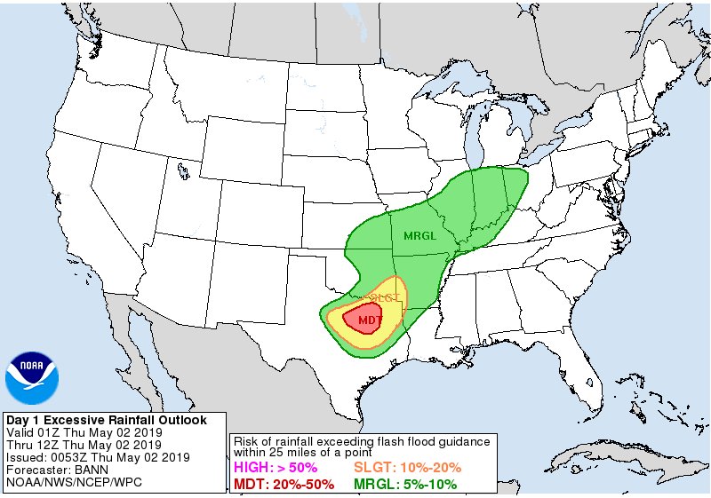
Re: Texas Spring 2019
Flooding risk will increase the next 24/36 hours. Very efficient rain producers.


4 likes
The above post and any post by Ntxw is NOT an official forecast and should not be used as such. It is just the opinion of the poster and may or may not be backed by sound meteorological data. It is NOT endorsed by any professional institution including Storm2k. For official information, please refer to NWS products.
Help support Storm2K!
Return to “USA & Caribbean Weather”
Who is online
Users browsing this forum: Cpv17 and 102 guests