2019 Indicators: SST'S / Sal / MSLP / Steering / Shear / Instability (See updated graphics at first post)
Moderator: S2k Moderators
Forum rules

The posts in this forum are NOT official forecasts and should not be used as such. They are just the opinion of the poster and may or may not be backed by sound meteorological data. They are NOT endorsed by any professional institution or STORM2K. For official information, please refer to products from the National Hurricane Center and National Weather Service.


Re: 2019 Indicators: SST'S / Sal / MSLP / Steering / Shear / Instability (See updated graphics at first post)
who reckons the storms will form closer to land in 2019
1 likes
blonde stacey (xe/xem/xir)


-
TheStormExpert
Re: 2019 Indicators: SST'S / Sal / MSLP / Steering / Shear / Instability (See updated graphics at first post)
If it were to persist throughout the hurricane I can't see anything affecting the U.S. from the east, only the Western Caribbean.
1 likes
-
SFLcane

- S2K Supporter

- Posts: 10281
- Age: 48
- Joined: Sat Jun 05, 2010 1:44 pm
- Location: Lake Worth Florida
Re: 2019 Indicators: SST'S / Sal / MSLP / Steering / Shear / Instability (See updated graphics at first post)
See you in 2020 if the ECMWF is right lol...
https://twitter.com/BenNollWeather/status/1125392269354336256
https://twitter.com/BenNollWeather/status/1125392269354336256
1 likes
-
NotSparta

- Professional-Met

- Posts: 1677
- Age: 24
- Joined: Fri Aug 18, 2017 8:24 am
- Location: Naples, FL
- Contact:
Re: 2019 Indicators: SST'S / Sal / MSLP / Steering / Shear / Instability (See updated graphics at first post)
SFLcane wrote:See you in 2020 if the ECMWF is right lol...
https://twitter.com/BenNollWeather/status/1125392269354336256
It wasn't quite right in 2018
5 likes
This post was probably an opinion of mine, and in no way is official. Please refer to http://www.hurricanes.gov for official tropical analysis and advisories.
My website, with lots of tropical wx graphics, including satellite and recon: http://cyclonicwx.com
My website, with lots of tropical wx graphics, including satellite and recon: http://cyclonicwx.com
-
CyclonicFury

- Category 5

- Posts: 2038
- Age: 27
- Joined: Sun Jul 02, 2017 12:32 pm
- Location: NC
- Contact:
Re: 2019 Indicators: SST'S / Sal / MSLP / Steering / Shear / Instability (See updated graphics at first post)
SFLcane wrote:See you in 2020 if the ECMWF is right lol...
https://twitter.com/BenNollWeather/status/1125392269354336256
That's not how it works. Just because the Atlantic might be below average doesn't mean areas are free from threats.
Interestingly the ECMWF forecast shows a weak African Monsoon, if I remember correctly last year it also showed a weak WAM which did not verify at all.
3 likes
NCSU B.S. in Meteorology Class of 2021. Tropical weather blogger at http://www.cyclonicfury.com. My forecasts and thoughts are NOT official, for official forecasts please consult the National Hurricane Center.
-
crownweather

- S2K Supporter
- Posts: 602
- Age: 51
- Joined: Sat Aug 12, 2006 9:21 am
- Location: Sturbridge, Massachusetts
- Contact:
Re: 2019 Indicators: SST'S / Sal / MSLP / Steering / Shear / Instability (See updated graphics at first post)
SFLcane wrote:See you in 2020 if the ECMWF is right lol...
https://twitter.com/BenNollWeather/status/1125392269354336256
Definitely not. Even though the Euro seasonal is showing below average tropical cyclone activity, it is also showing enhanced rainfall signals along the East Coast of the US. Also the monthly ensemble means from the Euro seasonal hints at above average rainfall in the NE Gulf of Mexico & especially from NE Florida to the Jersey coast in August.
Honestly, I think in-close development is a real concern this season & even in-close development can spin up & intensify quite fast (i.e. Elena 1985, Diana 1984, Humberto 2007).
1 likes
Rob Lightbown
Crown Weather Services
https://crownweather.com
Crown Weather Services
https://crownweather.com
-
CyclonicFury
- Category 5
- Posts: 2038
- Age: 27
- Joined: Sun Jul 02, 2017 12:32 pm
- Location: NC
- Contact:
Re: 2019 Indicators: SST'S / Sal / MSLP / Steering / Shear / Instability (See updated graphics at first post)
It's not surprising to see the EC so bearish on Atlantic TC activity. That model's high bias with surface pressures over the Atlantic is definitely impacting its TC forecasts. While El Nino will likely continue for at least a few more months, and the 60% of normal forecast may not be that outlandish, the EC's seasonal forecasts for the Atlantic have been pretty bad. I've also noticed it predicts a weak west African monsoon, which would certainly impact the forecast. I believe it showed the same thing last season, when precipitable water over the Sahel region was well above average for most of the season.
If I remember correctly, last year it predicted less than 10 named storms for the Atlantic with ACE ~50% of normal. In 2017 it didn't do very well either.
If I remember correctly, last year it predicted less than 10 named storms for the Atlantic with ACE ~50% of normal. In 2017 it didn't do very well either.
1 likes
NCSU B.S. in Meteorology Class of 2021. Tropical weather blogger at http://www.cyclonicfury.com. My forecasts and thoughts are NOT official, for official forecasts please consult the National Hurricane Center.

Re: 2019 Indicators: SST'S / Sal / MSLP / Steering / Shear / Instability (See updated graphics at first post)
CyclonicFury wrote:SFLcane wrote:See you in 2020 if the ECMWF is right lol...
https://twitter.com/BenNollWeather/status/1125392269354336256
That's not how it works. Just because the Atlantic might be below average doesn't mean areas are free from threats.
Interestingly the ECMWF forecast shows a weak African Monsoon, if I remember correctly last year it also showed a weak WAM which did not verify at all.
What SFLcane suggested was obviously tongue in cheek. The essential point being that if this ECMWF forecast verifies, one would broadly expect a significantly reduced Atlantic Hurricane season as well as an under average ACE for the season. To what extent relative smaller "Goldilocks" regions of more favorable conditions might still exist simply suggest, both smaller windows where formative conditions may exist and smaller windows for potential track and "time over water" intensity potential. There's no question that the decades long history of Atlantic Storm tracks show's multiple examples of intense "home-grown" or near land storm tracks which ultimately impacted the U.S. That merely suggests the obvious; During Hurricane Season potential risk is always present. Overall though, I do believe that ENSO related stronger then normal Southern Jet winds and anomalously higher 500mb heights through most of the MDR, Caribbean, and Gulf will help mitigate the threat of moderate to stronger tropical cyclones from impacting typically prone regions of the Caribbean, GOM, and S.E. CONUS. I'm less concerned about a potential for 2-3 GOM Tropical Storm tracks impacting the N.E. Gulf, then the greater more ominous threat some season's present for a powerful hurricane to strike. Hopefully, we won't see an Elena, Andrew, or Charlie find their way toward a N. GOM or Florida W. Coast track during this season. Dependent on overall steering however, I think the Eastern (and/or Northeast U.S. or Canadian Maritimes) U.S. Seaboard regions, Bermuda, and the Azores might well see a bit more of an amplified Hurricane impact risk this year. With any luck, the Lesser and Greater Antilles will get "a pass" this year with a decreased risk of storm tracks toward those regions.
0 likes
Andy D
(For official information, please refer to the NHC and NWS products.)
(For official information, please refer to the NHC and NWS products.)
Re: 2019 Indicators: SST'S / Sal / MSLP / Steering / Shear / Instability (See updated graphics at first post)
CyclonicFury wrote:It's not surprising to see the EC so bearish on Atlantic TC activity. That model's high bias with surface pressures over the Atlantic is definitely impacting its TC forecasts. While El Nino will likely continue for at least a few more months, and the 60% of normal forecast may not be that outlandish, the EC's seasonal forecasts for the Atlantic have been pretty bad. I've also noticed it predicts a weak west African monsoon, which would certainly impact the forecast. I believe it showed the same thing last season, when precipitable water over the Sahel region was well above average for most of the season.
If I remember correctly, last year it predicted less than 10 named storms for the Atlantic with ACE ~50% of normal. In 2017 it didn't do very well either.
This too is a solid point. If it were not for present ENSO conditions and my own belief that ENSO will possibly amplify during May-August, I'd be a good deal more skeptical of the EURO's typical bias depicting the Atlantic as a high pressure dust bowl.
0 likes
Andy D
(For official information, please refer to the NHC and NWS products.)
(For official information, please refer to the NHC and NWS products.)
-
SFLcane
- S2K Supporter
- Posts: 10281
- Age: 48
- Joined: Sat Jun 05, 2010 1:44 pm
- Location: Lake Worth Florida
Re: 2019 Indicators: SST'S / Sal / MSLP / Steering / Shear / Instability (See updated graphics at first post)
I for one do not think el nino will not play a significant role this season but we shall see.
https://twitter.com/jameil123456/status/1125506750327685121
https://twitter.com/jameil123456/status/1125506750327685121
3 likes
-
Hurricaneman

- Category 5
- Posts: 7404
- Age: 45
- Joined: Tue Aug 31, 2004 3:24 pm
- Location: central florida
Re: 2019 Indicators: SST'S / Sal / MSLP / Steering / Shear / Instability (See updated graphics at first post)
Honestly I’d go neutral ENSO for hurricane season and may even end up at 0 for peak season IMO as the WWBs are not making it past the dateline so we’ll see as that will be the thing that may separate an active season and a below average season
1 likes
-
Hurricaneman
- Category 5
- Posts: 7404
- Age: 45
- Joined: Tue Aug 31, 2004 3:24 pm
- Location: central florida
Re: 2019 Indicators: SST'S / Sal / MSLP / Steering / Shear / Instability (See updated graphics at first post)
I also noticed that if the ENSO somehow goes negative 1985 may pop up as an analog with a very similar Atlantic SSTA and fits with closer to land development with cooler MDR so that may be something to watch for
1 likes
-
weathaguyry

- Category 5
- Posts: 1273
- Age: 22
- Joined: Wed Jun 15, 2016 5:16 am
- Location: Long Island, NY
Re: 2019 Indicators: SST'S / Sal / MSLP / Steering / Shear / Instability (See updated graphics at first post)
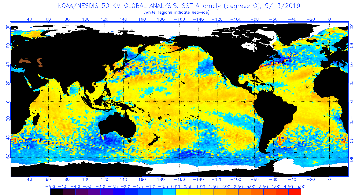
Now that it is becoming increasingly likely that the ENSO will have a minimal effect on the Atlantic hurricane season, I think there is a shot for a fairly active season. The SST profile is far from ideal, but the MDR is either at or above normal in most spots, and the WAM looks to be decently strong this year. Of course it is May and there are many factors that can change, but I personally believe that this season will be at least as active as last year, if not more.
1 likes
My posts are only my opinions and NOT official forecasts. For official forecasts, consult the National Hurricane Center or the National Weather Service.
Irene 11', Sandy 12', Fay 20’, Isaias 20’, Elsa 21’, Henri 21’, Ida 21’
Irene 11', Sandy 12', Fay 20’, Isaias 20’, Elsa 21’, Henri 21’, Ida 21’
-
NotSparta
- Professional-Met
- Posts: 1677
- Age: 24
- Joined: Fri Aug 18, 2017 8:24 am
- Location: Naples, FL
- Contact:
Re: 2019 Indicators: SST'S / Sal / MSLP / Steering / Shear / Instability (See updated graphics at first post)
No doubt the WAM will be a favorable indicator again this yr

3 likes
This post was probably an opinion of mine, and in no way is official. Please refer to http://www.hurricanes.gov for official tropical analysis and advisories.
My website, with lots of tropical wx graphics, including satellite and recon: http://cyclonicwx.com
My website, with lots of tropical wx graphics, including satellite and recon: http://cyclonicwx.com
-
TheStormExpert
Re: 2019 Indicators: SST'S / Sal / MSLP / Steering / Shear / Instability (See updated graphics at first post)
1 likes
-
NotSparta
- Professional-Met
- Posts: 1677
- Age: 24
- Joined: Fri Aug 18, 2017 8:24 am
- Location: Naples, FL
- Contact:
Re: 2019 Indicators: SST'S / Sal / MSLP / Steering / Shear / Instability (See updated graphics at first post)
TheStormExpert wrote::uarrow: Could this also allow storms to form sooner and recurve OTS away from land? Would love to track some Cape Verde long-trackers that harmlessly affect only the fishes.
I hope there's lots of recurvature. It does look like this will make it more favorable for storms to form earlier, but we still need to figure out how ridging is, as that is the big factor. We weren't so lucky the past 2 yrs
0 likes
This post was probably an opinion of mine, and in no way is official. Please refer to http://www.hurricanes.gov for official tropical analysis and advisories.
My website, with lots of tropical wx graphics, including satellite and recon: http://cyclonicwx.com
My website, with lots of tropical wx graphics, including satellite and recon: http://cyclonicwx.com
-
TheStormExpert
Re: 2019 Indicators: SST'S / Sal / MSLP / Steering / Shear / Instability (See updated graphics at first post)
NotSparta wrote:TheStormExpert wrote::uarrow: Could this also allow storms to form sooner and recurve OTS away from land? Would love to track some Cape Verde long-trackers that harmlessly affect only the fishes.
I hope there's lots of recurvature. It does look like this will make it more favorable for storms to form earlier, but we still need to figure out how ridging is, as that is the big factor. We weren't so lucky the past 2 yrs
Yes the NAO was mostly positive the last few years during the peak months, but as of lately it has been holding steadily negative. I wonder if it’ll remain that way all summer for once a lot like back in 2010.
1 likes
Re: 2019 Indicators: SST'S / Sal / MSLP / Steering / Shear / Instability (See updated graphics at first post)
We've often seen a number of high amplitude tropical wave migrating westward from the African coast, appear to have more then one point of clear vorticity. Often times where low latitude conditions are not conducive to development, the convection along the north and east of that wave or "inverted V" becomes dominant (assuming favorable conditions of course). I think I recall this type of wave as being referenced as a flying or screaming eagle (??). In any case, should typically lower MDR regions still be experiencing strong westerly shear then one result of course might simply cause many waves to weaken as they push west outpacing their MLC. On the other hand, a strong African monsoonal flow and healthy wave train could also result in some development to occur at somewhat higher latitudes (as described above) but then likely become susceptible to a quicker re-curve track in the process. On the other hand we've also seen circumstances where strong Atlantic waves seem to wilt under Atlantic high surface pressures, dry air, upper level conditions, etc. yet suddenly begin to see it's southern wave axis become much more active over coastal S. America and as it enters into the W. Caribbean as well. Some positive conditions appear to be in play this season. Just a matter of where conditions will ultimately be conducive enough for development to occur, and where those storm tracks will carry them from there.
1 likes
Andy D
(For official information, please refer to the NHC and NWS products.)
(For official information, please refer to the NHC and NWS products.)
Who is online
Users browsing this forum: Bing [Bot], mixedDanilo.E and 161 guests