2019 Indicators: SST'S / Sal / MSLP / Steering / Shear / Instability (See updated graphics at first post)
Moderator: S2k Moderators
Forum rules

The posts in this forum are NOT official forecasts and should not be used as such. They are just the opinion of the poster and may or may not be backed by sound meteorological data. They are NOT endorsed by any professional institution or STORM2K. For official information, please refer to products from the National Hurricane Center and National Weather Service.
-
Hurricaneman

- Category 5

- Posts: 7404
- Age: 45
- Joined: Tue Aug 31, 2004 3:24 pm
- Location: central florida
Re: 2019 Indicators: SST'S / Sal / MSLP / Steering / Shear / Instability (See updated graphics at first post)
The CDAS seems to be prone to error though, I would go with the NOAA one as that seems like the more official one
0 likes
-
NotSparta

- Professional-Met

- Posts: 1677
- Age: 24
- Joined: Fri Aug 18, 2017 8:24 am
- Location: Naples, FL
- Contact:
Re: 2019 Indicators: SST'S / Sal / MSLP / Steering / Shear / Instability (See updated graphics at first post)
Hurricaneman wrote:The CDAS seems to be prone to error though, I would go with the NOAA one as that seems like the more official one
Problem is NOAA baseline is atrocious and regularly is biased towards +AMOs
3 likes
This post was probably an opinion of mine, and in no way is official. Please refer to http://www.hurricanes.gov for official tropical analysis and advisories.
My website, with lots of tropical wx graphics, including satellite and recon: http://cyclonicwx.com
My website, with lots of tropical wx graphics, including satellite and recon: http://cyclonicwx.com

Re: 2019 Indicators: SST'S / Sal / MSLP / Steering / Shear / Instability (See updated graphics at first post)
Lets compared apples to apples using the same sources, what we can all agree with is that the MDR is warmer right now that this same time last year.


Edit: added CDAS:


Edit: added CDAS:
4 likes
-
cycloneye

- Admin

- Posts: 149719
- Age: 69
- Joined: Thu Oct 10, 2002 10:54 am
- Location: San Juan, Puerto Rico
Re: 2019 Indicators: SST'S / Sal / MSLP / Steering / Shear / Instability (See updated graphics at first post)
2 likes
Visit the Caribbean-Central America Weather Thread where you can find at first post web cams,radars
and observations from Caribbean basin members Click Here
and observations from Caribbean basin members Click Here
-
BYG Jacob
Re: 2019 Indicators: SST'S / Sal / MSLP / Steering / Shear / Instability (See updated graphics at first post)
Anomalies are cool and all, but what are the actual SSTs over the MDR?
0 likes
-
NotSparta
- Professional-Met
- Posts: 1677
- Age: 24
- Joined: Fri Aug 18, 2017 8:24 am
- Location: Naples, FL
- Contact:
Re: 2019 Indicators: SST'S / Sal / MSLP / Steering / Shear / Instability (See updated graphics at first post)
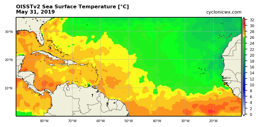
BYG Jacob wrote:Anomalies are cool and all, but what are the actual SSTs over the MDR?
They may be a bit biased low w/ the recent SAL, but:
1 likes
This post was probably an opinion of mine, and in no way is official. Please refer to http://www.hurricanes.gov for official tropical analysis and advisories.
My website, with lots of tropical wx graphics, including satellite and recon: http://cyclonicwx.com
My website, with lots of tropical wx graphics, including satellite and recon: http://cyclonicwx.com
-
AnnularCane

- S2K Supporter

- Posts: 2964
- Joined: Thu Jun 08, 2006 9:18 am
- Location: Wytheville, VA
Re: 2019 Indicators: SST'S / Sal / MSLP / Steering / Shear / Instability (See updated graphics at first post)
storm_in_a_teacup wrote:So like I know for the western Gulf the really bad stuff usually comes at the end of August/beginning of September. I was planning to go back to Houston during July-early August since usually that's not too bad, but I guess what you guys seem to imply is those times will be bad for the western Gulf as well?
I heard talk that it might be quiet until about mid-July or so, but now we have 91L, so... I guess only time will tell! Hopefully you won't experience too many issues in Houston, but there's really no telling until something happens, or doesn't.
Sorry, not sure how helpful that was. But just keep an eye on things and see what happens, and prepare if necessary.
2 likes
-
TheStormExpert
Re: 2019 Indicators: SST'S / Sal / MSLP / Steering / Shear / Instability (See updated graphics at first post)
SAL has been at its lowest levels in the MDR this spring in at least 16 years!
https://twitter.com/MichaelRLowry/status/1135003230331645952
https://twitter.com/MichaelRLowry/status/1135003230331645952
3 likes
-
storm_in_a_teacup

- Category 2

- Posts: 500
- Age: 33
- Joined: Wed Aug 16, 2017 5:01 pm
- Location: Huntsville, Alabama (originally from Houston)
- Contact:
Re: 2019 Indicators: SST'S / Sal / MSLP / Steering / Shear / Instability (See updated graphics at first post)
NotSparta wrote:Hurricaneman wrote:The CDAS seems to be prone to error though, I would go with the NOAA one as that seems like the more official one
Problem is NOAA baseline is atrocious and regularly is biased towards +AMOs
Please forgive me here but what is an AMO? I assume it's some kind of oscillation, but I don't recognize the initials.
1 likes
I know I can't straddle the atmosphere...just a tiny storm in your teacup, girl.
-
StruThiO

- Category 3

- Posts: 821
- Age: 26
- Joined: Fri Sep 15, 2017 5:51 am
- Location: Currently Portland, OR. Raised in Jax, FL.
Re: 2019 Indicators: SST'S / Sal / MSLP / Steering / Shear / Instability (See updated graphics at first post)
storm_in_a_teacup wrote:Please forgive me here but what is an AMO? I assume it's some kind of oscillation, but I don't recognize the initials.
Atlantic Multidecadal Oscillation, the climate cycle that's responsible for the Atlantic's current high activity era that began in 1995
0 likes
-
NotSparta
- Professional-Met
- Posts: 1677
- Age: 24
- Joined: Fri Aug 18, 2017 8:24 am
- Location: Naples, FL
- Contact:
Re: 2019 Indicators: SST'S / Sal / MSLP / Steering / Shear / Instability (See updated graphics at first post)
storm_in_a_teacup wrote:NotSparta wrote:Hurricaneman wrote:The CDAS seems to be prone to error though, I would go with the NOAA one as that seems like the more official one
Problem is NOAA baseline is atrocious and regularly is biased towards +AMOs
Please forgive me here but what is an AMO? I assume it's some kind of oscillation, but I don't recognize the initials.
The Atlantic Multidecadal Oscillation, the positive phase has a warm MDR and far North Atlantic, and typically features more TC activity
2 likes
This post was probably an opinion of mine, and in no way is official. Please refer to http://www.hurricanes.gov for official tropical analysis and advisories.
My website, with lots of tropical wx graphics, including satellite and recon: http://cyclonicwx.com
My website, with lots of tropical wx graphics, including satellite and recon: http://cyclonicwx.com
-
StruThiO
- Category 3
- Posts: 821
- Age: 26
- Joined: Fri Sep 15, 2017 5:51 am
- Location: Currently Portland, OR. Raised in Jax, FL.
Re: 2019 Indicators: SST'S / Sal / MSLP / Steering / Shear / Instability (See updated graphics at first post)
TheStormExpert wrote:SAL has been at its lowest levels in the MDR this spring in at least 16 years!
https://twitter.com/MichaelRLowry/status/1135003230331645952
judging by that graphic, 2005, 2010, and 2017 had above average dust, so not sure if this can be used as a positive indicator for the Atlantic
3 likes
Re: 2019 Indicators: SST'S / Sal / MSLP / Steering / Shear / Instability (See updated graphics at first post)
StruThiO wrote:TheStormExpert wrote:SAL has been at its lowest levels in the MDR this spring in at least 16 years!
https://twitter.com/MichaelRLowry/status/1135003230331645952
judging by that graphic, 2005, 2010, and 2017 had above average dust, so not sure if this can be used as a positive indicator for the Atlantic
I'm questioning that graphic in general. I'm like 98% sure that back in 2017 either during the spring or early summer one of the pro mets mentioned on twitter that SAL was at its lowest levels since 2005. That graphic does not reflect anything like that. I'm suspicious.
Maybe I'm wrong though.
2 likes
Solar Aquarian
Lunar Cancerian
 Sagittarian
Lunar Cancerian
Re: 2019 Indicators: SST'S / Sal / MSLP / Steering / Shear / Instability (See updated graphics at first post)
StruThiO wrote:TheStormExpert wrote:SAL has been at its lowest levels in the MDR this spring in at least 16 years!
https://twitter.com/MichaelRLowry/status/1135003230331645952
judging by that graphic, 2005, 2010, and 2017 had above average dust, so not sure if this can be used as a positive indicator for the Atlantic
The graph is only during spring, if memory serves me correct 2005 did have below average SAL outbreaks during the summer. So probably most important is if SAL will stay below average or not through the next summer months.
3 likes
Re: 2019 Indicators: SST'S / Sal / MSLP / Steering / Shear / Instability (See updated graphics at first post)
Yet another image to compare to this same time last year. So far warmer than last year but not as warm as '16 & '17.


0 likes
-
weathaguyry

- Category 5
- Posts: 1273
- Age: 22
- Joined: Wed Jun 15, 2016 5:16 am
- Location: Long Island, NY
Re: 2019 Indicators: SST'S / Sal / MSLP / Steering / Shear / Instability (See updated graphics at first post)
I really think the takeaway is that SST's are so variable that they aren't a great indicator for the season as a whole, especially considering we are only on the second day of the season. No matter what, the SST's will always be warm enough to sustain hurricanes in the deep tropics and the GOM by August, it's all a matter of atmospheric conditions such as SAL and shear, which seem that they may be at least lower than last year. We are all itching to track monster canes rolling through the Atlantic, but we have to sit back for a little while and focus on the little slop systems until mother nature is ready to give us her worst 
5 likes
My posts are only my opinions and NOT official forecasts. For official forecasts, consult the National Hurricane Center or the National Weather Service.
Irene 11', Sandy 12', Fay 20’, Isaias 20’, Elsa 21’, Henri 21’, Ida 21’
Irene 11', Sandy 12', Fay 20’, Isaias 20’, Elsa 21’, Henri 21’, Ida 21’

Re: 2019 Indicators: SST'S / Sal / MSLP / Steering / Shear / Instability (See updated graphics at first post)
weathaguyry wrote:I really think the takeaway is that SST's are so variable that they aren't a great indicator for the season as a whole, especially considering we are only on the second day of the season. No matter what, the SST's will always be warm enough to sustain hurricanes in the deep tropics and the GOM by August, it's all a matter of atmospheric conditions such as SAL and shear, which seem that they may be at least lower than last year. We are all itching to track monster canes rolling through the Atlantic, but we have to sit back for a little while and focus on the little slop systems until mother nature is ready to give us her worst
Good point. I think SST's are only particularly relevant when they might be unusually cool. Anomalously high SST could play into an increased RI potential but only if all other dynamics are in place for cyclogenesis to even occur.
By the way..... anyone notice how nicely the Atlantic ITCZ is beginning to flare up? Then again, "that's occuring" barely north of the equator around 2N-4N
0 likes
Andy D
(For official information, please refer to the NHC and NWS products.)
(For official information, please refer to the NHC and NWS products.)
-
NotSparta
- Professional-Met
- Posts: 1677
- Age: 24
- Joined: Fri Aug 18, 2017 8:24 am
- Location: Naples, FL
- Contact:
Re: 2019 Indicators: SST'S / Sal / MSLP / Steering / Shear / Instability (See updated graphics at first post)
chaser1 wrote:weathaguyry wrote:I really think the takeaway is that SST's are so variable that they aren't a great indicator for the season as a whole, especially considering we are only on the second day of the season. No matter what, the SST's will always be warm enough to sustain hurricanes in the deep tropics and the GOM by August, it's all a matter of atmospheric conditions such as SAL and shear, which seem that they may be at least lower than last year. We are all itching to track monster canes rolling through the Atlantic, but we have to sit back for a little while and focus on the little slop systems until mother nature is ready to give us her worst
Good point. I think SST's are only particularly relevant when they might be unusually cool. Anomalously high SST could play into an increased RI potential but only if all other dynamics are in place for cyclogenesis to even occur.
By the way..... anyone notice how nicely the Atlantic ITCZ is beginning to flare up? Then again, "that's occuring" barely north of the equator around 2N-4N
Well, it is only early June
0 likes
This post was probably an opinion of mine, and in no way is official. Please refer to http://www.hurricanes.gov for official tropical analysis and advisories.
My website, with lots of tropical wx graphics, including satellite and recon: http://cyclonicwx.com
My website, with lots of tropical wx graphics, including satellite and recon: http://cyclonicwx.com
-
cycloneye
- Admin
- Posts: 149719
- Age: 69
- Joined: Thu Oct 10, 2002 10:54 am
- Location: San Juan, Puerto Rico
Re: 2019 Indicators: SST'S / Sal / MSLP / Steering / Shear / Instability (See updated graphics at first post)
1 likes
Visit the Caribbean-Central America Weather Thread where you can find at first post web cams,radars
and observations from Caribbean basin members Click Here
and observations from Caribbean basin members Click Here
-
Hurricaneman
- Category 5
- Posts: 7404
- Age: 45
- Joined: Tue Aug 31, 2004 3:24 pm
- Location: central florida
Re: 2019 Indicators: SST'S / Sal / MSLP / Steering / Shear / Instability (See updated graphics at first post)
2005 might not be as big an analog as I thought but 2004 looks closer to a good analog along with 1969 with a madoki look to the El Niño and the Atlantic trending towards a similar look temperature and shear wise
1 likes
Who is online
Users browsing this forum: USTropics and 152 guests