Texas Summer 2019

U.S. & Caribbean Weather Discussions and Severe Weather Events

Moderator: S2k Moderators

Forum rules

The posts in this forum are NOT official forecast and should not be used as such. They are just the opinion of the poster and may or may not be backed by sound meteorological data. They are NOT endorsed by any professional institution or STORM2K.

Help Support Storm2K
Message
Author
User avatar
TheProfessor
Professional-Met
Professional-Met
Posts: 3506
Age: 28
Joined: Tue Dec 03, 2013 10:56 am
Location: Wichita, Kansas

Re: Texas Summer 2019

#381 Postby TheProfessor » Fri Jun 21, 2019 9:27 pm

1900hurricane wrote:The dewpoint briefly touched 80ºF here today. That's a little excessive.


Accuweather had me at a dewpoint of 82 lol. It was cloudy when I was walking the dog though so it didn't feel too bad.
1 likes   
An alumnus of The Ohio State University.

Your local National Weather Service office is your best source for weather information.

Brent
S2K Supporter
S2K Supporter
Posts: 38088
Age: 36
Joined: Sun May 16, 2004 10:30 pm
Location: Tulsa Oklahoma
Contact:

Re: Texas Summer 2019

#382 Postby Brent » Fri Jun 21, 2019 9:37 pm

Not one but two squall lines for DFW on the 0z NAM between tomorrow evening at this time and Sunday morning :double:

Also has some scattered storms Sunday afternoon which would have severe potential too probably

Image
Image
1 likes   
#neversummer

User avatar
bubba hotep
S2K Supporter
S2K Supporter
Posts: 5837
Joined: Wed Dec 28, 2016 1:00 am
Location: Collin County Texas

Re: Texas Summer 2019

#383 Postby bubba hotep » Fri Jun 21, 2019 9:50 pm

Brent wrote:Not one but two squall lines for DFW on the 0z NAM between tomorrow evening at this time and Sunday morning :double:

Also has some scattered storms Sunday afternoon which would have severe potential too probably

https://i.ibb.co/RN6Gbtx/nam3km-mslp-pcpn-frzn-scus-26.png
https://i.ibb.co/68qjZBc/nam3km-mslp-pcpn-frzn-scus-33.png


Widespread 4-6" totals for DFW!
0 likes   
Winter time post are almost exclusively focused on the DFW area.

User avatar
bubba hotep
S2K Supporter
S2K Supporter
Posts: 5837
Joined: Wed Dec 28, 2016 1:00 am
Location: Collin County Texas

Re: Texas Summer 2019

#384 Postby bubba hotep » Fri Jun 21, 2019 9:59 pm

Some South Texas folks getting slammed tonight

Image
1 likes   
Winter time post are almost exclusively focused on the DFW area.

Brent
S2K Supporter
S2K Supporter
Posts: 38088
Age: 36
Joined: Sun May 16, 2004 10:30 pm
Location: Tulsa Oklahoma
Contact:

Re: Texas Summer 2019

#385 Postby Brent » Fri Jun 21, 2019 10:11 pm

bubba hotep wrote:
Brent wrote:Not one but two squall lines for DFW on the 0z NAM between tomorrow evening at this time and Sunday morning :double:

Also has some scattered storms Sunday afternoon which would have severe potential too probably

https://i.ibb.co/RN6Gbtx/nam3km-mslp-pcpn-frzn-scus-26.png
https://i.ibb.co/68qjZBc/nam3km-mslp-pcpn-frzn-scus-33.png


Widespread 4-6" totals for DFW!


And yet the NWS only has 30% Saturday Night and 40% Sunday what gives
0 likes   
#neversummer

User avatar
bubba hotep
S2K Supporter
S2K Supporter
Posts: 5837
Joined: Wed Dec 28, 2016 1:00 am
Location: Collin County Texas

Re: Texas Summer 2019

#386 Postby bubba hotep » Fri Jun 21, 2019 10:40 pm

Brent wrote:
bubba hotep wrote:
Brent wrote:Not one but two squall lines for DFW on the 0z NAM between tomorrow evening at this time and Sunday morning :double:

Also has some scattered storms Sunday afternoon which would have severe potential too probably

https://i.ibb.co/RN6Gbtx/nam3km-mslp-pcpn-frzn-scus-26.png
https://i.ibb.co/68qjZBc/nam3km-mslp-pcpn-frzn-scus-33.png


Widespread 4-6" totals for DFW!


And yet the NWS only has 30% Saturday Night and 40% Sunday what gives


And no mention of a Flash Flood Watch in the afternoon AFD.
0 likes   
Winter time post are almost exclusively focused on the DFW area.

User avatar
Ntxw
Storm2k Moderator
Storm2k Moderator
Posts: 22784
Joined: Wed Oct 21, 2009 6:34 pm
Location: DFW, Texas

Re: Texas Summer 2019

#387 Postby Ntxw » Fri Jun 21, 2019 11:32 pm

It will likely warrant flash flood watches. I suspect the nws may have to hoist them up.

The air is ripe for heavy rain.
3 likes   
The above post and any post by Ntxw is NOT an official forecast and should not be used as such. It is just the opinion of the poster and may or may not be backed by sound meteorological data. It is NOT endorsed by any professional institution including Storm2k. For official information, please refer to NWS products.

  Help support Storm2K!
Help Support Storm2K

Brent
S2K Supporter
S2K Supporter
Posts: 38088
Age: 36
Joined: Sun May 16, 2004 10:30 pm
Location: Tulsa Oklahoma
Contact:

Re: Texas Summer 2019

#388 Postby Brent » Fri Jun 21, 2019 11:44 pm

Ntxw wrote:It will likely warrant flash flood watches. I suspect the nws may have to hoist them up.

The air is ripe for heavy rain.


now I will say the models the news show had no widespread rain til Sunday Night, didn't show anything close to what the NAM has tomorrow night, and honestly the NAM has been consistent with at least one line in the timeframe

but those same models failed on Wednesday :roflmao:

Also the SPC day 1 doesnt even have the metro in a marginal
0 likes   
#neversummer

User avatar
Ntxw
Storm2k Moderator
Storm2k Moderator
Posts: 22784
Joined: Wed Oct 21, 2009 6:34 pm
Location: DFW, Texas

Re: Texas Summer 2019

#389 Postby Ntxw » Sat Jun 22, 2019 7:13 am

Brent wrote:
Ntxw wrote:It will likely warrant flash flood watches. I suspect the nws may have to hoist them up.

The air is ripe for heavy rain.


now I will say the models the news show had no widespread rain til Sunday Night, didn't show anything close to what the NAM has tomorrow night, and honestly the NAM has been consistent with at least one line in the timeframe

but those same models failed on Wednesday :roflmao:

Also the SPC day 1 doesnt even have the metro in a marginal


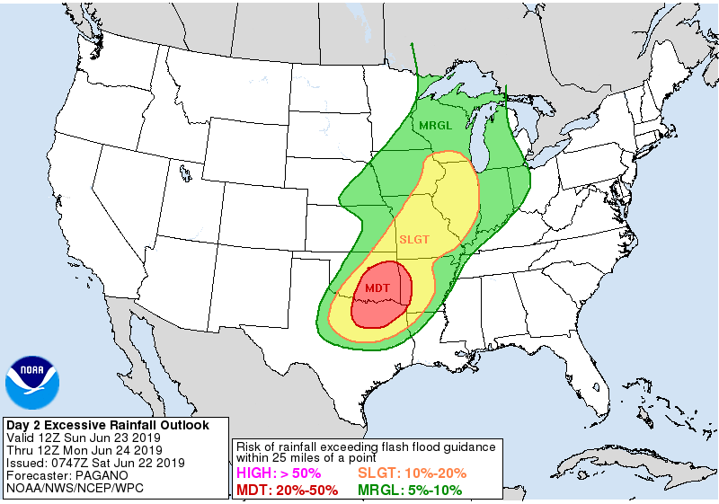
Severe weather is finicky. This isn't about severe weather though. This is a pretty solid MCS, it is not so much about initiation. It will come through and pwats are high.

Moderate risk for excessive rainfall has been extended down to include more of NTX.
0 likes   
The above post and any post by Ntxw is NOT an official forecast and should not be used as such. It is just the opinion of the poster and may or may not be backed by sound meteorological data. It is NOT endorsed by any professional institution including Storm2k. For official information, please refer to NWS products.


  Help support Storm2K!

Help Support Storm2K


User avatar
Ntxw
Storm2k Moderator
Storm2k Moderator
Posts: 22784
Joined: Wed Oct 21, 2009 6:34 pm
Location: DFW, Texas

Re: Texas Summer 2019

#390 Postby Ntxw » Sat Jun 22, 2019 7:18 am

Image
1 likes   
The above post and any post by Ntxw is NOT an official forecast and should not be used as such. It is just the opinion of the poster and may or may not be backed by sound meteorological data. It is NOT endorsed by any professional institution including Storm2k. For official information, please refer to NWS products.


  Help support Storm2K!

Help Support Storm2K


User avatar
bubba hotep
S2K Supporter
S2K Supporter
Posts: 5837
Joined: Wed Dec 28, 2016 1:00 am
Location: Collin County Texas

Re: Texas Summer 2019

#391 Postby bubba hotep » Sat Jun 22, 2019 10:13 am

Welp that was fun while it lasted... pretty much all the 12z HiRes models pull the plug on N. Texas rain of any significance and now have everything in far eastern Ok lol
2 likes   
Winter time post are almost exclusively focused on the DFW area.

gpsnowman
S2K Supporter
S2K Supporter
Posts: 3185
Joined: Fri Jan 07, 2011 10:35 am
Location: Grand Prairie Tx

Re: Texas Summer 2019

#392 Postby gpsnowman » Sat Jun 22, 2019 10:18 am

bubba hotep wrote:Welp that was fun while it lasted... pretty much all the 12z HiRes models pull the plug on N. Texas rain of any significance and now have everything in far eastern Ok lol

I noticed that. The morning reports from Fox 4 and channel 8 showed the same thing, most of the rain in Oklahoma. Still a chance here with cooler temps though.
0 likes   

User avatar
bubba hotep
S2K Supporter
S2K Supporter
Posts: 5837
Joined: Wed Dec 28, 2016 1:00 am
Location: Collin County Texas

Re: Texas Summer 2019

#393 Postby bubba hotep » Sat Jun 22, 2019 10:25 am

00z 3k NAM, which showed this solution for a about 2 straight days

Image

Now the 12z 3k NAM

Image
1 likes   
Winter time post are almost exclusively focused on the DFW area.

DonWrk
Category 1
Category 1
Posts: 488
Age: 37
Joined: Mon Jan 03, 2011 11:54 pm
Location: Collinsville, TX

Re: Texas Summer 2019

#394 Postby DonWrk » Sat Jun 22, 2019 10:36 am

bubba hotep wrote:Welp that was fun while it lasted... pretty much all the 12z HiRes models pull the plug on N. Texas rain of any significance and now have everything in far eastern Ok lol


Wouldn’t expect anything less with a shift into eastern Oklahoma lol.
0 likes   

User avatar
bubba hotep
S2K Supporter
S2K Supporter
Posts: 5837
Joined: Wed Dec 28, 2016 1:00 am
Location: Collin County Texas

Re: Texas Summer 2019

#395 Postby bubba hotep » Sat Jun 22, 2019 10:43 am

Looking at things, it looks like the models are firing too much convection across the warm sector and that is preventing the MCS from developing in SW OK and then crashing into N. Texas. HiRes models do seem to be overly aggressive with warm sector convection, so lets' see if a bunch of convection fires in Texas and then lifts into Eastern OK. If that doesn't happen or isn't as robust as models show then we turn or focus to SW OK and watch for a MCS to develop.

The SPC ENH area in SW OK would be the area to watch for MCS development late this afternoon.

Image
0 likes   
Winter time post are almost exclusively focused on the DFW area.

User avatar
Ntxw
Storm2k Moderator
Storm2k Moderator
Posts: 22784
Joined: Wed Oct 21, 2009 6:34 pm
Location: DFW, Texas

Re: Texas Summer 2019

#396 Postby Ntxw » Sat Jun 22, 2019 11:06 am

The feature that the short range guidance creates lift to generate the eastern Oklahoma convection is currently meandering through the west side of C-TX. It could trigger some afternoon activity in NTX later today. This is the remnants of the MCV that went through SW and S Texas yesterday evening.

Image
1 likes   
The above post and any post by Ntxw is NOT an official forecast and should not be used as such. It is just the opinion of the poster and may or may not be backed by sound meteorological data. It is NOT endorsed by any professional institution including Storm2k. For official information, please refer to NWS products.


  Help support Storm2K!

Help Support Storm2K


rwfromkansas
Category 5
Category 5
Posts: 2627
Joined: Sat Aug 27, 2005 12:47 am
Location: North Fort Worth

Re: Texas Summer 2019

#397 Postby rwfromkansas » Sat Jun 22, 2019 11:30 am

Would something like that create subsidence and kill any MCS late overnight?
0 likes   

User avatar
Ntxw
Storm2k Moderator
Storm2k Moderator
Posts: 22784
Joined: Wed Oct 21, 2009 6:34 pm
Location: DFW, Texas

Re: Texas Summer 2019

#398 Postby Ntxw » Sat Jun 22, 2019 11:37 am

rwfromkansas wrote:Would something like that create subsidence and kill any MCS late overnight?


I wouldn't think subsidence is the main issue. Being summer time steering is going to be the question the next 12 hours. We'll get an MCS tomorrow afternoon/evening but this evening is dependent on weak steering, and which complex takes over. FW AFD had a great discussion about the dual steering.

.SHORT TERM... /Issued 310 AM CDT Sat Jun 22 2019/
/Through Tonight/

Relatively low predictability exists regarding convective chances
over the next 24 hours. Those with outdoor activities today
through tonight should have methods of monitoring the weather
with the potential for scattered strong storms throughout this
time period. Increased cloud cover should keep temperatures a
couple degrees lower than yesterday, preventing heat indices from
climbing above 105 for most locations, thus no heat headlines are
advertised.

Similar to the past several days, an open warm sector with 70+
degree dewpoints will exist across the region, with temperatures
expected to climb into the upper 80s and 90s. Steep lapse rates
exist through the mid levels, which will yield very strong
instability through the peak heating hours as surface based
inhibition erodes. The main question mark through the day will be
the lifting mechanisms, and whether they will be sufficient to
initiate and sustain deep moist convection. A subtle upstream
shortwave exists across West Texas which will pivot over the area
today. In addition, there is some indication that a convectively
induced vorticity lobe from ongoing convection across southwest
Texas (or perhaps a smaller scale MCV feature) may join with the
larger scale impulse within southwesterly flow aloft. Should this
occur, these features could allow for scattered convective
initiation attempts through the afternoon hours today, although
they would be highly disorganized without a the presence of a
focusing surface boundary. Given the magnitude of instability but
modest shear, a localized threat for borderline strong/severe
multicellular storms could exist, with a potential for hail and
downburst winds. Confidence in coverage, placement, and timing are
all rather low through this afternoon/evening, so modest broad
PoPs have been advertised. A plausible alternate scenario through
the afternoon is that no convection is able to develop at all if
lift is more absent compared to what guidance currently indicates.

Regardless of how things unfold this afternoon, additional
convective chances may exist this evening and tonight, as
convection to our northwest grows upscale into an MCS. While a
complex in this environment should exhibit elements of both
upwind and downwind propagation, its unclear which may be favored
at this point. Upwind propagation would favor a more southeastward
motion, possibly steering the complex into North Texas late this
evening and overnight, while downwind propagation would keep most
activity to the north in Oklahoma. There could at least be a
lower-end strong/severe wind threat, especially near the Red
River should a complex remain robust into the overnight hours.
Areas south of I-20 are largely expected to be dry tonight, unless
a complex maintains much better organization than currently
anticipated.


-Stalley
0 likes   
The above post and any post by Ntxw is NOT an official forecast and should not be used as such. It is just the opinion of the poster and may or may not be backed by sound meteorological data. It is NOT endorsed by any professional institution including Storm2k. For official information, please refer to NWS products.


  Help support Storm2K!

Help Support Storm2K


User avatar
bubba hotep
S2K Supporter
S2K Supporter
Posts: 5837
Joined: Wed Dec 28, 2016 1:00 am
Location: Collin County Texas

Re: Texas Summer 2019

#399 Postby bubba hotep » Sat Jun 22, 2019 11:43 am

Ntxw wrote:The feature that the short range guidance creates lift to generate the eastern Oklahoma convection is currently meandering through the west side of C-TX. It could trigger some afternoon activity in NTX later today. This is the remnants of the MCV that went through SW and S Texas yesterday evening.

https://images2.imgbox.com/17/77/EbgSfc3R_o.gif


A lot going on in that loop. The remnant MCV appears to be drifting N-NW, which is putting it a long ways from helping set storms in SE OK later today. Also, looks like Eastern OK is capped pretty good right now.
1 likes   
Winter time post are almost exclusively focused on the DFW area.

User avatar
funster
Category 3
Category 3
Posts: 816
Joined: Sat Dec 29, 2007 4:27 pm
Location: North Dallas

Re: Texas Summer 2019

#400 Postby funster » Sat Jun 22, 2019 2:59 pm

surprise pop-up downpour in N Dallas. A little thunder. And it's over. Sun coming back out...
0 likes   


Return to “USA & Caribbean Weather”

Who is online

Users browsing this forum: Cpv17, ElectricStorm, txtwister78 and 15 guests