https://twitter.com/BigJoeBastardi/status/1147165127277514752
2019 Indicators: SST'S / Sal / MSLP / Steering / Shear / Instability (See updated graphics at first post)
Moderator: S2k Moderators
Forum rules

The posts in this forum are NOT official forecasts and should not be used as such. They are just the opinion of the poster and may or may not be backed by sound meteorological data. They are NOT endorsed by any professional institution or STORM2K. For official information, please refer to products from the National Hurricane Center and National Weather Service.
-
cycloneye

- Admin

- Posts: 149720
- Age: 69
- Joined: Thu Oct 10, 2002 10:54 am
- Location: San Juan, Puerto Rico
Re: 2019 Indicators: SST'S / Sal / MSLP / Steering / Shear / Instability (See updated graphics at first post)
0 likes
Visit the Caribbean-Central America Weather Thread where you can find at first post web cams,radars
and observations from Caribbean basin members Click Here
and observations from Caribbean basin members Click Here
-
toad strangler

- S2K Supporter

- Posts: 4546
- Joined: Sun Jul 28, 2013 3:09 pm
- Location: Earth
- Contact:
Re: 2019 Indicators: SST'S / Sal / MSLP / Steering / Shear / Instability (See updated graphics at first post)
cycloneye wrote:https://twitter.com/BigJoeBastardi/status/1147165127277514752
I like JB but it's still too early for deep MDR action to being with so saying it's closed for business doesn't tell me much. Main MDR go time is August through September.
0 likes
My Weather Station
https://www.wunderground.com/dashboard/pws/KFLPORTS603
https://www.wunderground.com/dashboard/pws/KFLPORTS603
-
CyclonicFury

- Category 5

- Posts: 2038
- Age: 27
- Joined: Sun Jul 02, 2017 12:32 pm
- Location: NC
- Contact:
Re: 2019 Indicators: SST'S / Sal / MSLP / Steering / Shear / Instability (See updated graphics at first post)
cycloneye wrote:https://twitter.com/BigJoeBastardi/status/1147165127277514752
JB always says the MDR is closed until activity actually picks up there.
4 likes
NCSU B.S. in Meteorology Class of 2021. Tropical weather blogger at http://www.cyclonicfury.com. My forecasts and thoughts are NOT official, for official forecasts please consult the National Hurricane Center.
-
cycloneye
- Admin
- Posts: 149720
- Age: 69
- Joined: Thu Oct 10, 2002 10:54 am
- Location: San Juan, Puerto Rico
Re: 2019 Indicators: SST'S / Sal / MSLP / Steering / Shear / Instability (See updated graphics at first post)
Great video discussion bu Mark Sudduth (hurricanetrack) about the NGOM situation for late next week.
https://twitter.com/hurricanetrack/status/1147194553016967170
https://twitter.com/hurricanetrack/status/1147194553016967170
6 likes
Visit the Caribbean-Central America Weather Thread where you can find at first post web cams,radars
and observations from Caribbean basin members Click Here
and observations from Caribbean basin members Click Here
-
gatorcane

- S2K Supporter
- Posts: 23708
- Age: 48
- Joined: Sun Mar 13, 2005 3:54 pm
- Location: Boca Raton, FL
Re: 2019 Indicators: SST'S / Sal / MSLP / Steering / Shear / Instability (See updated graphics at first post)
Hurricaneman wrote:Shell Mound wrote:Very important—and potentially bad—indicators for the prospects of U.S. impacts by peak season:
https://twitter.com/antmasiello/status/1146479491415511042
https://twitter.com/antmasiello/status/1146481379103952898
https://twitter.com/antmasiello/status/1146831219277148160
https://twitter.com/antmasiello/status/1146832215042666497
https://twitter.com/antmasiello/status/1146836371883118592
https://twitter.com/antmasiello/status/1146837609001422853
Looks like 2004 may be emerging as a top analog which means from the Carolinas to New Orleans May be at highest risk
The posts in this forum are NOT official forecast and should not be used as such. They are just the opinion of the poster and may or may not be backed by sound meteorological data. They are NOT endorsed by any professional institution or STORM2K. For official information, please refer to products from the National Hurricane Center and National Weather Service.
Hmm I don’t see a 2004 redux. It does seem like the Bermuda High is not as strong as it has been the past few years at this time. Things seem back to “normal” this year as far as the Bermuda High is concerned. The past few years we were going weeks with deep easterly flow across South Florida now we are switching between SW flow and east flow periodically. Of course the long-wave pattern happening now probably doesn’t mean much come peak of hurricane season. My hunch is that we will see some Cape Verde long trackers but I think we will see more recurves east of Florida this year. I think threats to Florida, if any, would be from the Caribbean or close, quick spin up type scenarios.
0 likes
-
TheStormExpert
Re: 2019 Indicators: SST'S / Sal / MSLP / Steering / Shear / Instability (See updated graphics at first post)
gatorcane wrote:Hurricaneman wrote:Shell Mound wrote:Very important—and potentially bad—indicators for the prospects of U.S. impacts by peak season:
https://twitter.com/antmasiello/status/1146479491415511042
https://twitter.com/antmasiello/status/1146481379103952898
https://twitter.com/antmasiello/status/1146831219277148160
https://twitter.com/antmasiello/status/1146832215042666497
https://twitter.com/antmasiello/status/1146836371883118592
https://twitter.com/antmasiello/status/1146837609001422853
Looks like 2004 may be emerging as a top analog which means from the Carolinas to New Orleans May be at highest riskThe posts in this forum are NOT official forecast and should not be used as such. They are just the opinion of the poster and may or may not be backed by sound meteorological data. They are NOT endorsed by any professional institution or STORM2K. For official information, please refer to products from the National Hurricane Center and National Weather Service.
Hmm I don’t see a 2004 redux. It does seem like the Bermuda High is not as strong as it has been the past few years at this time. Things seem back to “normal” this year as far as the Bermuda High is concerned. The past few years we were going weeks with deep easterly flow across South Florida now we are switching between SW flow and east flow periodically. Of course the long-wave pattern happening now probably doesn’t mean much come peak of hurricane season. My hunch is that we will see some Cape Verde long trackers but I think we will see more recurves east of Florida this year. I think threats to Florida, if any, would be from the Caribbean or close, quick spin up type scenarios.
Our biggest threats if any will likely be in October yet again if the steering pattern we’re in continues.
This is likely to be the first summer since 2014 where the Bermuda High is little non-existent.
2004 shouldn’t even be brought up in my opinion.
0 likes
-
NotSparta

- Professional-Met

- Posts: 1677
- Age: 24
- Joined: Fri Aug 18, 2017 8:24 am
- Location: Naples, FL
- Contact:
Re: 2019 Indicators: SST'S / Sal / MSLP / Steering / Shear / Instability (See updated graphics at first post)
TheStormExpert wrote:gatorcane wrote:Hurricaneman wrote:Looks like 2004 may be emerging as a top analog which means from the Carolinas to New Orleans May be at highest riskThe posts in this forum are NOT official forecast and should not be used as such. They are just the opinion of the poster and may or may not be backed by sound meteorological data. They are NOT endorsed by any professional institution or STORM2K. For official information, please refer to products from the National Hurricane Center and National Weather Service.
Hmm I don’t see a 2004 redux. It does seem like the Bermuda High is not as strong as it has been the past few years at this time. Things seem back to “normal” this year as far as the Bermuda High is concerned. The past few years we were going weeks with deep easterly flow across South Florida now we are switching between SW flow and east flow periodically. Of course the long-wave pattern happening now probably doesn’t mean much come peak of hurricane season. My hunch is that we will see some Cape Verde long trackers but I think we will see more recurves east of Florida this year. I think threats to Florida, if any, would be from the Caribbean or close, quick spin up type scenarios.
Our biggest threats if any will likely be in October yet again if the steering pattern we’re in continues.
This is likely to be the first summer since 2014 where the Bermuda High is little non-existent.
2004 shouldn’t even be brought up in my opinion.
Hopefully that -NAO continues
0 likes
This post was probably an opinion of mine, and in no way is official. Please refer to http://www.hurricanes.gov for official tropical analysis and advisories.
My website, with lots of tropical wx graphics, including satellite and recon: http://cyclonicwx.com
My website, with lots of tropical wx graphics, including satellite and recon: http://cyclonicwx.com

Re: 2019 Indicators: SST'S / Sal / MSLP / Steering / Shear / Instability (See updated graphics at first post)
TheStormExpert wrote:gatorcane wrote:Hurricaneman wrote:Looks like 2004 may be emerging as a top analog which means from the Carolinas to New Orleans May be at highest riskThe posts in this forum are NOT official forecast and should not be used as such. They are just the opinion of the poster and may or may not be backed by sound meteorological data. They are NOT endorsed by any professional institution or STORM2K. For official information, please refer to products from the National Hurricane Center and National Weather Service.
Hmm I don’t see a 2004 redux. It does seem like the Bermuda High is not as strong as it has been the past few years at this time. Things seem back to “normal” this year as far as the Bermuda High is concerned. The past few years we were going weeks with deep easterly flow across South Florida now we are switching between SW flow and east flow periodically. Of course the long-wave pattern happening now probably doesn’t mean much come peak of hurricane season. My hunch is that we will see some Cape Verde long trackers but I think we will see more recurves east of Florida this year. I think threats to Florida, if any, would be from the Caribbean or close, quick spin up type scenarios.
Our biggest threats if any will likely be in October yet again if the steering pattern we’re in continues.
This is likely to be the first summer since 2014 where the Bermuda High is little non-existent.
2004 shouldn’t even be brought up in my opinion.
For the record the NAO was not positive the whole time during the hurricane season in 2004, it was negative during June then went positive in July before going back negative in August, that’s why Charlie had that crazy track because of an unseasonal cold front that dropped down to the Deep South.
The NAO still has time to go back positive before the heart of the hurricane season like it did in 2008.
4 likes
-
Shell Mound
- Category 5
- Posts: 2432
- Age: 33
- Joined: Thu Sep 07, 2017 3:39 pm
- Location: St. Petersburg, FL → Scandinavia
Re: 2019 Indicators: SST'S / Sal / MSLP / Steering / Shear / Instability (See updated graphics at first post)
This study sampled Florida hurricane impacts from 1900 to 2000. The study noted that "there does not appear to be any relationship between NAO phase and location of hurricane landfall. An equal number of positive and negative NAO phase years for both East Coast (Table 1) and Florida landfalls (Table 2) are observed." However, more major hurricane landfalls occurred when the NAO was positive, whereas hurricane impacts during -NAOs tended to be weaker. Exceptions occurred in 1917 (Cat-3), 1933 (Cat-3), 1947 (Cat-4), and 1960 (DONNA, Cat-4). +NAO events occurred in 1919 (Cat-4), 1921 (Cat-3), 1926 (Cat-4), 1928 (Cat-4), 1935 (Cat-5), 1945 (Cat-4), 1948 (Cat-4), 1950 (KING, Cat-4), and 1992 (ANDREW, Cat-5). Note, however, that the study only utilised one methodology to measure the state of the NAO. There are several different indices by which the NAO may be calibrated.
1 likes
CVW / MiamiensisWx / Shell Mound
The posts in this forum are NOT official forecasts and should not be used as such. They are just the opinion of the poster and may or may not be backed by sound meteorological data. They are NOT endorsed by any professional institution or STORM2K. For official information, please refer to products from the NHC and NWS.
Re: 2019 Indicators: SST'S / Sal / MSLP / Steering / Shear / Instability (See updated graphics at first post)
Shell Mound wrote:This study sampled Florida hurricane impacts from 1900 to 2000. The study noted that "there does not appear to be any relationship between NAO phase and location of hurricane landfall. An equal number of positive and negative NAO phase years for both East Coast (Table 1) and Florida landfalls (Table 2) are observed." However, more major hurricane landfalls occurred when the NAO was positive, whereas hurricane impacts during -NAOs tended to be weaker. Exceptions occurred in 1917 (Cat-3), 1933 (Cat-3), 1947 (Cat-4), and 1960 (DONNA, Cat-4). +NAO events occurred in 1919 (Cat-4), 1921 (Cat-3), 1926 (Cat-4), 1928 (Cat-4), 1935 (Cat-5), 1945 (Cat-4), 1948 (Cat-4), 1950 (KING, Cat-4), and 1992 (ANDREW, Cat-5). Note, however, that the study only utilised one methodology to measure the state of the NAO. There are several different indices by which the NAO may be calibrated.
That makes sense, Charley can be added to the instance that FL got hit by a Major Hurricane when the NAO was negative, but had it been positive Charlie would had made landfall much further west into TX or MX.
It all depends where the storm forms, had Charlie formed further east it would had missed FL all together because of the trough. IMO.
1 likes
-
cycloneye
- Admin
- Posts: 149720
- Age: 69
- Joined: Thu Oct 10, 2002 10:54 am
- Location: San Juan, Puerto Rico
Re: 2019 Indicators: SST'S / Sal / MSLP / Steering / Shear / Instability (See updated graphics at first post)
Great discussion thread by Tyler Stanfield.
https://twitter.com/TylerJStanfield/status/1147629110040113154
https://twitter.com/TylerJStanfield/status/1147632276534169602
https://twitter.com/TylerJStanfield/status/1147635419145809922
https://twitter.com/TylerJStanfield/status/1147949822260981760
https://twitter.com/TylerJStanfield/status/1147629110040113154
https://twitter.com/TylerJStanfield/status/1147632276534169602
https://twitter.com/TylerJStanfield/status/1147635419145809922
https://twitter.com/TylerJStanfield/status/1147949822260981760
2 likes
Visit the Caribbean-Central America Weather Thread where you can find at first post web cams,radars
and observations from Caribbean basin members Click Here
and observations from Caribbean basin members Click Here
-
gatorcane
- S2K Supporter
- Posts: 23708
- Age: 48
- Joined: Sun Mar 13, 2005 3:54 pm
- Location: Boca Raton, FL
Re: 2019 Indicators: SST'S / Sal / MSLP / Steering / Shear / Instability (See updated graphics at first post)
The waves rolling off Africa are looking rather robust just like the last few years at this time:
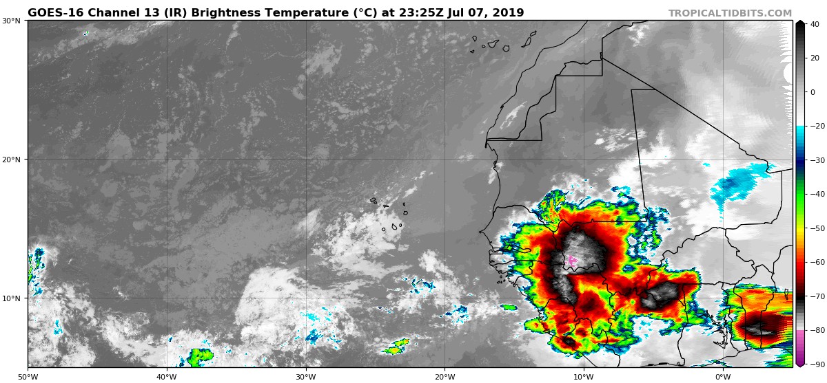
6 likes
-
StruThiO

- Category 3

- Posts: 821
- Age: 26
- Joined: Fri Sep 15, 2017 5:51 am
- Location: Currently Portland, OR. Raised in Jax, FL.
Re: 2019 Indicators: SST'S / Sal / MSLP / Steering / Shear / Instability (See updated graphics at first post)
Just a bit of a difference from last year wrt to the AMO


1 likes
-
gatorcane
- S2K Supporter
- Posts: 23708
- Age: 48
- Joined: Sun Mar 13, 2005 3:54 pm
- Location: Boca Raton, FL
Re: 2019 Indicators: SST'S / Sal / MSLP / Steering / Shear / Instability (See updated graphics at first post)
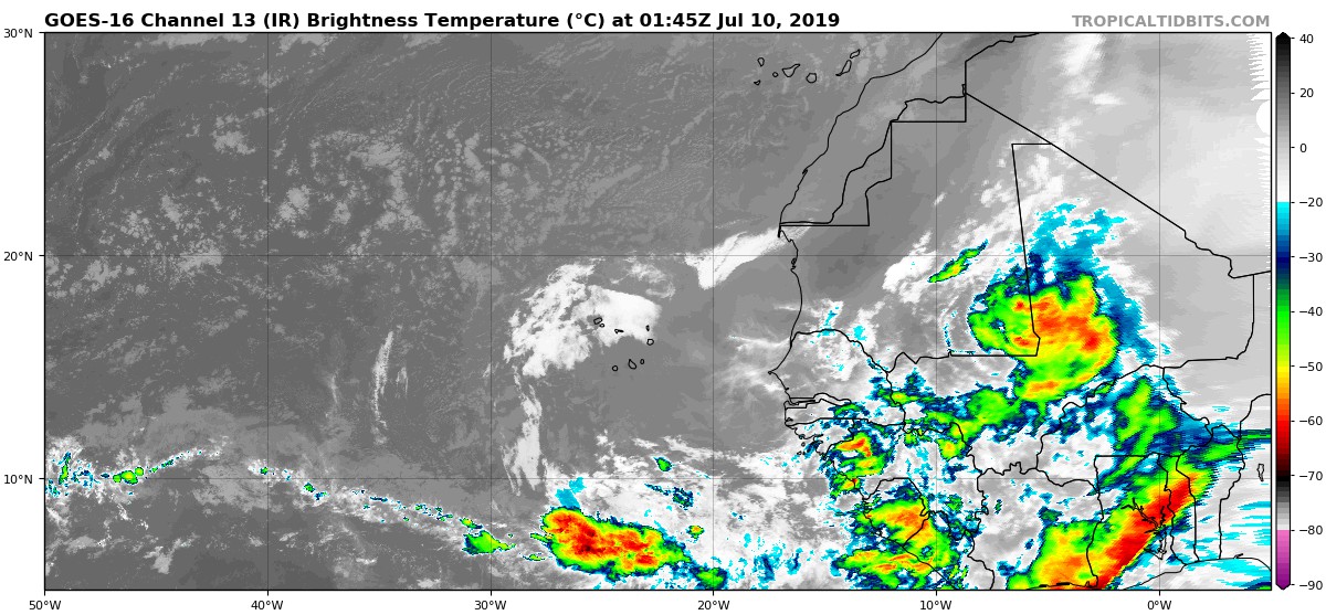
Seems like yet again these waves are quite a bit north in latitude. I remember the last couple of years were similar. Perhaps this high latitude convection will further put a dent in the SAL:
0 likes
-
TheStormExpert
Re: 2019 Indicators: SST'S / Sal / MSLP / Steering / Shear / Instability (See updated graphics at first post)
Does anyone else get the vibe that this season is going to feature a lot of weak sloppy storms like in 2012 or 2001? Vertical Instability is lacking in several different areas of the Atlantic currently including the Gulf of Mexico, Caribbean, and Tropical Atlantic. Doesn't paint a good picture if you're banking on an active or high in quantity season. If this is the case then we may not see more than two majors and only a handful of hurricanes.
0 likes


Re: 2019 Indicators: SST'S / Sal / MSLP / Steering / Shear / Instability (See updated graphics at first post)
TheStormExpert wrote:Does anyone else get the vibe that this season is going to feature a lot of weak sloppy storms like in 2012 or 2001? Vertical Instability is lacking in several different areas of the Atlantic currently including the Gulf of Mexico, Caribbean, and Tropical Atlantic. Doesn't paint a good picture if you're banking on an active or high in quantity season. If this is the case then we may not see more than two majors and only a handful of hurricanes.
When was the last season that vertical instability was above average (or even average) in the Atlantic? Not in the past 7 years. Don’t think it’s a good idea to bet activity on that parameter or on a July storm ingesting continental air.
5 likes
-
tolakram
- Admin
- Posts: 20186
- Age: 62
- Joined: Sun Aug 27, 2006 8:23 pm
- Location: Florence, KY (name is Mark)
Re: 2019 Indicators: SST'S / Sal / MSLP / Steering / Shear / Instability (See updated graphics at first post)
TheStormExpert wrote:Does anyone else get the vibe that this season is going to feature a lot of weak sloppy storms like in 2012 or 2001? Vertical Instability is lacking in several different areas of the Atlantic currently including the Gulf of Mexico, Caribbean, and Tropical Atlantic. Doesn't paint a good picture if you're banking on an active or high in quantity season. If this is the case then we may not see more than two majors and only a handful of hurricanes.
Those indicators have been meaningless for the last few years. Every year, regardless of activity, they indicate below normal. The only time they go above normal is when there's activity, so it's more of a lagging indicator. The MDR and Caribbean are way below normal at the moment due to the dust outbreak. The Gulf has been near average but typically storms nearing the coast of the Gulf have to contend with dry air. That's one thing that made Michael so unique. It's not going to happen every year.

Most experts are calling for a near normal season, and a normal season is pretty much what you describe.
4 likes
M a r k
- - - - -
Join us in chat: Storm2K Chatroom Invite. Android and IOS apps also available.
The posts in this forum are NOT official forecasts and should not be used as such. Posts are NOT endorsed by any professional institution or STORM2K.org. For official information and forecasts, please refer to NHC and NWS products.

Re: 2019 Indicators: SST'S / Sal / MSLP / Steering / Shear / Instability (See updated graphics at first post)
TheStormExpert wrote:Does anyone else get the vibe that this season is going to feature a lot of weak sloppy storms like in 2012 or 2001?
Yep, felt it in April. Still feeling it in July
2 likes
Andy D
(For official information, please refer to the NHC and NWS products.)
(For official information, please refer to the NHC and NWS products.)
-
StruThiO
- Category 3
- Posts: 821
- Age: 26
- Joined: Fri Sep 15, 2017 5:51 am
- Location: Currently Portland, OR. Raised in Jax, FL.
Re: 2019 Indicators: SST'S / Sal / MSLP / Steering / Shear / Instability (See updated graphics at first post)
The vertical shear is quite low for this time of year. I know some use Caribbean shear this time of year to forecast activity later on - does shear in the rest of the MDR have any statistical significance for the rest of the season or is it noise?


1 likes
-
StruThiO
- Category 3
- Posts: 821
- Age: 26
- Joined: Fri Sep 15, 2017 5:51 am
- Location: Currently Portland, OR. Raised in Jax, FL.
Re: 2019 Indicators: SST'S / Sal / MSLP / Steering / Shear / Instability (See updated graphics at first post)
that warm horseshoe look

0 likes
Who is online
Users browsing this forum: Google Adsense [Bot] and 130 guests