
2019 Indicators: SST'S / Sal / MSLP / Steering / Shear / Instability (See updated graphics at first post)
Moderator: S2k Moderators
Forum rules

The posts in this forum are NOT official forecasts and should not be used as such. They are just the opinion of the poster and may or may not be backed by sound meteorological data. They are NOT endorsed by any professional institution or STORM2K. For official information, please refer to products from the National Hurricane Center and National Weather Service.
-
crownweather

- S2K Supporter

- Posts: 602
- Age: 51
- Joined: Sat Aug 12, 2006 9:21 am
- Location: Sturbridge, Massachusetts
- Contact:
Re: 2019 Indicators: SST'S / Sal / MSLP / Steering / Shear / Instability (See updated graphics at first post)
For those that have brought up the 2004 hurricane season as a analog, check out the 18Z GFS and the 12Z Euro EPS models. Both have some sort of development very near the East Coast of the US at the beginning of August as a tropical wave interacts with a pretty robust trough of low pressure. This is very similar to what we saw with Alex in 2004 at the very end of July. If anything, it's a little intriguing.
3 likes
Rob Lightbown
Crown Weather Services
https://crownweather.com
Crown Weather Services
https://crownweather.com
-
TheStormExpert
Re: 2019 Indicators: SST'S / Sal / MSLP / Steering / Shear / Instability (See updated graphics at first post)
crownweather wrote:For those that have brought up the 2004 hurricane season as a analog, check out the 18Z GFS and the 12Z Euro EPS models. Both have some sort of development very near the East Coast of the US at the beginning of August as a tropical wave interacts with a pretty robust trough of low pressure. This is very similar to what we saw with Alex in 2004 at the very end of July. If anything, it's a little intriguing.
https://i.imgur.com/p95tHmb.png
The other day you were saying how 1991 seemed like a reasonable analog, could you please explain your reasoning more?
0 likes
-
crownweather
- S2K Supporter
- Posts: 602
- Age: 51
- Joined: Sat Aug 12, 2006 9:21 am
- Location: Sturbridge, Massachusetts
- Contact:
Re: 2019 Indicators: SST'S / Sal / MSLP / Steering / Shear / Instability (See updated graphics at first post)
TheStormExpert wrote:crownweather wrote:For those that have brought up the 2004 hurricane season as a analog, check out the 18Z GFS and the 12Z Euro EPS models. Both have some sort of development very near the East Coast of the US at the beginning of August as a tropical wave interacts with a pretty robust trough of low pressure. This is very similar to what we saw with Alex in 2004 at the very end of July. If anything, it's a little intriguing.
https://i.imgur.com/p95tHmb.png
The other day you were saying how 1991 seemed like a reasonable analog, could you please explain your reasoning more?
The big reason why I brought up 1991 as a possible analog is the many of the extreme heat records set here in the Northeastern United States last weekend were last set in 1991. Also, most of the development that year was north of 20 North Latitude, which if the seasonal guidance is correct, we could see a similar evolution this season with tropical waves waiting to develop until they are out of the MDR. It was just a thought that was thrown out there into the ether.
2 likes
Rob Lightbown
Crown Weather Services
https://crownweather.com
Crown Weather Services
https://crownweather.com
-
gatorcane

- S2K Supporter
- Posts: 23708
- Age: 48
- Joined: Sun Mar 13, 2005 3:54 pm
- Location: Boca Raton, FL
Re: 2019 Indicators: SST'S / Sal / MSLP / Steering / Shear / Instability (See updated graphics at first post)
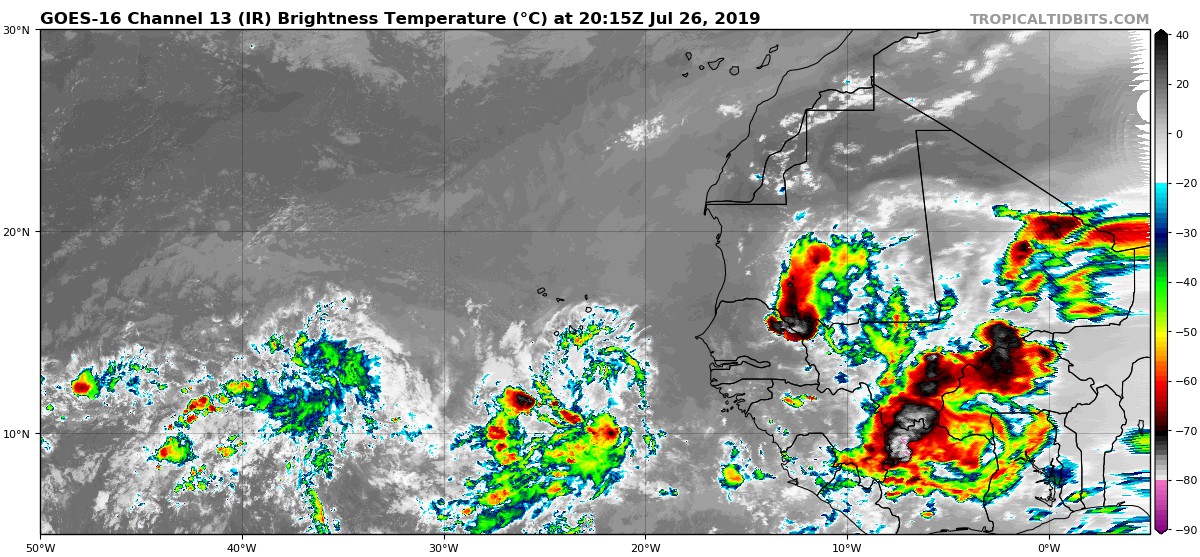
The waves rolling off Africa look just as impressive as the last few years at this time. Here is the latest image:
5 likes
-
cycloneye

- Admin

- Posts: 149286
- Age: 69
- Joined: Thu Oct 10, 2002 10:54 am
- Location: San Juan, Puerto Rico
Re: 2019 Indicators: SST'S / Sal / MSLP / Steering / Shear / Instability (See updated graphics at first post)
0 likes
Visit the Caribbean-Central America Weather Thread where you can find at first post web cams,radars
and observations from Caribbean basin members Click Here
and observations from Caribbean basin members Click Here
-
Dylan

- Professional-Met

- Posts: 338
- Age: 31
- Joined: Mon May 31, 2010 9:50 am
- Location: New Orleans, LA
Re: 2019 Indicators: SST'S / Sal / MSLP / Steering / Shear / Instability (See updated graphics at first post)
1 likes
Georges('98), Allison('01), Isidore('02), Lili('02), Frances('04) Ivan('04), Cindy('05), Katrina('05), Rita('05), Gustav('08), Isaac('12), Matthew('16), Harvey('17), Irma('17), Nate ('17), Ida ('21).
-
cycloneye
- Admin
- Posts: 149286
- Age: 69
- Joined: Thu Oct 10, 2002 10:54 am
- Location: San Juan, Puerto Rico
Re: 2019 Indicators: SST'S / Sal / MSLP / Steering / Shear / Instability (See updated graphics at first post)
0 likes
Visit the Caribbean-Central America Weather Thread where you can find at first post web cams,radars
and observations from Caribbean basin members Click Here
and observations from Caribbean basin members Click Here
-
Monsoonjr99
- Tropical Storm

- Posts: 210
- Age: 26
- Joined: Fri Sep 21, 2018 11:22 pm
- Location: Inland Empire, SoCal
Re: 2019 Indicators: SST'S / Sal / MSLP / Steering / Shear / Instability (See updated graphics at first post)
So I've been reading this thread for a while and have seen some interesting analogs pop up.
1991 could work better in terms of formation locations and steering than overall activity. After all it is +AMO (albeit EOF 2) rather than -AMO.
I've seen 1893 mentioned as a year with EOF 2 AMO (like 2019) where steering directed a lot of east coast threats (like 1991). This year has had a persistent -NAO so storms riding up the east coast seems plausible.
2004 and 2005 have popped up based on SST configuration, but with the MDR being not as warm as those years with this EOF 2, I'm not so sure how good those work as analogs. ENSO this year has behaved somewhat in between 2004 and 2005/2017, where it's hard to say if it will be Modoki El Nino or cool neutral. I'm leaning towards a "Modoki warm neutral" where 3.4 is warm neutral but there is an east-based -ENSO approaching La Nina territory. This would make 2004 the better analog of those two I'd say.
I'd also bring up both 2017 and 2018 based on WAM. The MDR has been active the past two years, even 2018 in spite of the cold MDR, thanks to the strong WAM which continues this year. MDR SSTs this year are in between the past two. A warm MDR does promote much more activity than one that's just average, such as how 2005 (to bring that up again) had record activity despite not much of it being MDR-based. But I suppose even with the eastern MDR being cool as it has been lately, the WAM can overpower that like last year and allow more waves or TCs to reach the warmer SSTs to the west and north. Of course, 2017 was way more active than 2018 is part due to the activity within the warm MDR, but remember 2018's Caribbean shear wall.
Beyond analogs, I think the indicators this year are intriguing. The subtropical Atlantic to the north of the Caribbean could be a focal point this year, especially if a lot of disturbances from this strong WAM make it there. The Caribbean I think is more of a wild card though, as it has had an inactive phase since 2008, though ENSO may be able to wake it up again this year like 2016. Caribbean shear has been lower as of late. Looking at all those above average to hyperactive analogs I mentioned in this post, I think the Caribbean is what could be the difference between a hyperactive season or a "light" version of those analogs. I do think I'm perhaps being quite a bit bullish here...
Anyway, a CCKW is moving through and helping the AEWs moisten the environment and wash away the SAL. There may or may not be near-term development before the suppressed phase arrives, but it looks like the Atlantic is readying itself for peak season. I think the real wake up will begin once the suppressed phase of this CCKW is done moving through. Now let's wait and see what 2019 has in store for the next three months...
6 likes
The posts in this forum are NOT official forecasts and should not be used as such. They are just the opinion of the poster and may or may not be backed by sound meteorological data. They are NOT endorsed by any professional institution or STORM2K. For official information, please refer to products from the NHC and NWS.
Some Californian who codes things and tracks weather.
Kay '22, Hilary '23
-
Emmett_Brown

- Category 5

- Posts: 1433
- Joined: Wed Aug 24, 2005 9:10 pm
- Location: Sarasota FL
Re: 2019 Indicators: SST'S / Sal / MSLP / Steering / Shear / Instability (See updated graphics at first post)
Funny how the positive TC development conditions alway seem to show up in time for the real climo TC season.
4 likes
-
Shell Mound
- Category 5
- Posts: 2432
- Age: 33
- Joined: Thu Sep 07, 2017 3:39 pm
- Location: St. Petersburg, FL → Scandinavia
Re: 2019 Indicators: SST'S / Sal / MSLP / Steering / Shear / Instability (See updated graphics at first post)
Emmett_Brown wrote:Funny how the positive TC development conditions alway seem to show up in time for the real climo TC season.
Well, that is why they're climatologically favoured, after all.
Anyway, the subtropics, Gulf, and central MDR look to be the favoured regions of development in 2019. The Caribbean and western MDR look to be a bit sheared, similar to 2018, while the eastern MDR is a bit cool. So the favoured zone in the deep tropics looks to lie between the Cabo Verde islands and the Lesser Antilles, that is, in the central MDR. The remainder of development is likely occur north of the deep tropics, so we would need significant blocking to allow landfalls on the U.S.
2 likes
CVW / MiamiensisWx / Shell Mound
The posts in this forum are NOT official forecasts and should not be used as such. They are just the opinion of the poster and may or may not be backed by sound meteorological data. They are NOT endorsed by any professional institution or STORM2K. For official information, please refer to products from the NHC and NWS.
-
NotSparta

- Professional-Met
- Posts: 1677
- Age: 24
- Joined: Fri Aug 18, 2017 8:24 am
- Location: Naples, FL
- Contact:
Re: 2019 Indicators: SST'S / Sal / MSLP / Steering / Shear / Instability (See updated graphics at first post)
Shell Mound wrote:Emmett_Brown wrote:Funny how the positive TC development conditions alway seem to show up in time for the real climo TC season.
Well, that is why they're climatologically favoured, after all.
Anyway, the subtropics, Gulf, and central MDR look to be the favoured regions of development in 2019. The Caribbean and western MDR look to be a bit sheared, similar to 2018, while the eastern MDR is a bit cool. So the favoured zone in the deep tropics looks to lie between the Cabo Verde islands and the Lesser Antilles, that is, in the central MDR. The remainder of development is likely occur north of the deep tropics, so we would need significant blocking to allow landfalls on the U.S.
The shear isn't as bad as 2018, but yeah, it's still generally there. The main issue this yr has been the dry air
1 likes
This post was probably an opinion of mine, and in no way is official. Please refer to http://www.hurricanes.gov for official tropical analysis and advisories.
My website, with lots of tropical wx graphics, including satellite and recon: http://cyclonicwx.com
My website, with lots of tropical wx graphics, including satellite and recon: http://cyclonicwx.com

-
WeatherEmperor
- S2K Supporter
- Posts: 4806
- Age: 42
- Joined: Thu Sep 04, 2003 2:54 pm
- Location: South Florida
Re: 2019 Indicators: SST'S / Sal / MSLP / Steering / Shear / Instability (See updated graphics at first post)
With the exception of a brief slip into positive territory in July, the NAO has been negative for a surprising 3+ months and is forecast to go sharply negative in the next 1-2 weeks.
The NAO has been stuck in this negative pattern for so long and I have yet to see anything to suggest it flip to strongly positive.

Sent from my iPhone using Tapatalk
The NAO has been stuck in this negative pattern for so long and I have yet to see anything to suggest it flip to strongly positive.
Sent from my iPhone using Tapatalk
1 likes
-
TheStormExpert
Re: 2019 Indicators: SST'S / Sal / MSLP / Steering / Shear / Instability (See updated graphics at first post)
May have to watch to see how things play out come late-September into October for Western Caribbean development that could potentially threaten the U.S. thanks to the -NAO.
1 likes
-
jconsor
- Professional-Met
- Posts: 580
- Joined: Mon Jun 30, 2008 9:31 pm
- Location: Jerusalem, Israel
- Contact:
Re: 2019 Indicators: SST'S / Sal / MSLP / Steering / Shear / Instability (See updated graphics at first post)
No guarantee -NAO will continue beyond mid-Aug. Euro weeklies and CFS both suggest neutral to positive NAO returns second half of Aug.
TheStormExpert wrote::uarrow: With this kind of pattern everything should track safely offshore the east coast either between the east coast and Bermuda or east of that.
May have to watch to see how things play out come late-September into October for Western Caribbean development that could potentially threaten the U.S. thanks to the -NAO.
6 likes
-
crownweather
- S2K Supporter
- Posts: 602
- Age: 51
- Joined: Sat Aug 12, 2006 9:21 am
- Location: Sturbridge, Massachusetts
- Contact:
Re: 2019 Indicators: SST'S / Sal / MSLP / Steering / Shear / Instability (See updated graphics at first post)
jconsor wrote:No guarantee -NAO will continue beyond mid-Aug. Euro weeklies and CFS both suggest neutral to positive NAO returns second half of Aug.TheStormExpert wrote::uarrow: With this kind of pattern everything should track safely offshore the east coast either between the east coast and Bermuda or east of that.
May have to watch to see how things play out come late-September into October for Western Caribbean development that could potentially threaten the U.S. thanks to the -NAO.
Also, no guarantee that a tropical system will safely move offshore while moving along the East Coast. A deep enough trough oriented "the right way" could easily pull a system northward into the Northeast US or Atlantic Canada even with a -NAO.
6 likes
Rob Lightbown
Crown Weather Services
https://crownweather.com
Crown Weather Services
https://crownweather.com

Re: 2019 Indicators: SST'S / Sal / MSLP / Steering / Shear / Instability (See updated graphics at first post)
Does the NAO have any impact on activity in general or just helping determine the tracking trend?
0 likes
The above post is not official and should not be used as such. It is the opinion of the poster and may or may not be backed by sound meteorological data. It is not endorsed by any professional institution or storm2k.org. For official information, please refer to the NHC and NWS products.
-
USTropics
- Professional-Met
- Posts: 2737
- Joined: Sun Aug 12, 2007 3:45 am
- Location: Florida State University
Re: 2019 Indicators: SST'S / Sal / MSLP / Steering / Shear / Instability (See updated graphics at first post)
Hammy wrote:Does the NAO have any impact on activity in general or just helping determine the tracking trend?
This study found no real correlation between activity (SSTA configuration played the most significant role), using a Poisson regression model encompassing 212 years of global atmospheric simulations from the HiRAM-C180 cubed-sphere dynamical core. A couple quotes from the article:
The strength of the trade winds and the position of the Bermuda high are indicated as the physical links between NAO and hurricane activity (e.g., Elsner et al. 2000b, 2001), with effects mostly associated with the steering of the hurricane tracks.
These results suggest that there are important remote influences (SOI and/or tropical mean SST) in explaining the fraction of hurricanes making U.S. landfall. As far as local influences are concerned, NAO is an important predictor, while tropical Atlantic SST is not, possibly because it affects the genesis and development rather than the hurricane tracking.
1 likes
-
TheStormExpert
Re: 2019 Indicators: SST'S / Sal / MSLP / Steering / Shear / Instability (See updated graphics at first post)
crownweather wrote:jconsor wrote:No guarantee -NAO will continue beyond mid-Aug. Euro weeklies and CFS both suggest neutral to positive NAO returns second half of Aug.TheStormExpert wrote::uarrow: With this kind of pattern everything should track safely offshore the east coast either between the east coast and Bermuda or east of that.
May have to watch to see how things play out come late-September into October for Western Caribbean development that could potentially threaten the U.S. thanks to the -NAO.
Also, no guarantee that a tropical system will safely move offshore while moving along the East Coast. A deep enough trough oriented "the right way" could easily pull a system northward into the Northeast US or Atlantic Canada even with a -NAO.
Like what we saw with Sandy (2012)
1 likes
Who is online
Users browsing this forum: Teban54 and 83 guests