
EPAC: ERICK - Remnants
Moderator: S2k Moderators
-
Kingarabian

- S2K Supporter

- Posts: 16344
- Joined: Sat Aug 08, 2009 3:06 am
- Location: Honolulu, Hawaii
-
Yellow Evan

- Professional-Met

- Posts: 16222
- Age: 27
- Joined: Fri Jul 15, 2011 12:48 pm
- Location: Henderson, Nevada/Honolulu, HI
- Contact:

-
Yellow Evan
- Professional-Met
- Posts: 16222
- Age: 27
- Joined: Fri Jul 15, 2011 12:48 pm
- Location: Henderson, Nevada/Honolulu, HI
- Contact:
Re: EPAC: ERICK - Tropical Storm
----- Current Analysis -----
Date : 28 JUL 2019 Time : 043000 UTC
Lat : 11:57:01 N Lon : 127:09:39 W
CI# /Pressure/ Vmax
3.0 /1001.5mb/ 45.0kt
Final T# Adj T# Raw T#
2.8 3.2 3.4
Center Temp : -76.1C Cloud Region Temp : -60.6C
Scene Type : UNIFORM CDO CLOUD REGION
Subtropical Adjustment : OFF
Extratropical Adjustment : OFF
Date : 28 JUL 2019 Time : 043000 UTC
Lat : 11:57:01 N Lon : 127:09:39 W
CI# /Pressure/ Vmax
3.0 /1001.5mb/ 45.0kt
Final T# Adj T# Raw T#
2.8 3.2 3.4
Center Temp : -76.1C Cloud Region Temp : -60.6C
Scene Type : UNIFORM CDO CLOUD REGION
Subtropical Adjustment : OFF
Extratropical Adjustment : OFF
0 likes
-
Yellow Evan
- Professional-Met
- Posts: 16222
- Age: 27
- Joined: Fri Jul 15, 2011 12:48 pm
- Location: Henderson, Nevada/Honolulu, HI
- Contact:
Re: EPAC: ERICK - Tropical Storm
TXPZ25 KNES 280618
TCSENP
A. 06E (ERICK)
B. 28/0600Z
C. 11.9N
D. 127.6W
E. THREE/GOES-W
F. T2.5/2.5/D0.5/24HRS
G. IR/EIR/SWIR
H. REMARKS...4/10 BANDING RESULTS IN A DT OF 2.5. MET AND PT AGREE. FT
IS BASED ON MET BECAUSE BANDING FEATURES WERE NOT CLEAR CUT.
I. ADDL POSITIONS
NIL
...TURK
TCSENP
A. 06E (ERICK)
B. 28/0600Z
C. 11.9N
D. 127.6W
E. THREE/GOES-W
F. T2.5/2.5/D0.5/24HRS
G. IR/EIR/SWIR
H. REMARKS...4/10 BANDING RESULTS IN A DT OF 2.5. MET AND PT AGREE. FT
IS BASED ON MET BECAUSE BANDING FEATURES WERE NOT CLEAR CUT.
I. ADDL POSITIONS
NIL
...TURK
0 likes
-
Kingarabian
- S2K Supporter
- Posts: 16344
- Joined: Sat Aug 08, 2009 3:06 am
- Location: Honolulu, Hawaii
Re: EPAC: ERICK - Tropical Storm
UW - CIMSS
ADVANCED DVORAK TECHNIQUE
ADT-Version 9.0
Tropical Cyclone Intensity Algorithm
----- Current Analysis -----
Date : 28 JUL 2019 Time : 063000 UTC
Lat : 12:01:02 N Lon : 127:38:55 W
CI# /Pressure/ Vmax
3.3 / 997.8mb/ 51.0kt
Final T# Adj T# Raw T#
3.3 3.6 4.0
ADVANCED DVORAK TECHNIQUE
ADT-Version 9.0
Tropical Cyclone Intensity Algorithm
----- Current Analysis -----
Date : 28 JUL 2019 Time : 063000 UTC
Lat : 12:01:02 N Lon : 127:38:55 W
CI# /Pressure/ Vmax
3.3 / 997.8mb/ 51.0kt
Final T# Adj T# Raw T#
3.3 3.6 4.0
0 likes
RIP Kobe Bryant
-
Kingarabian
- S2K Supporter
- Posts: 16344
- Joined: Sat Aug 08, 2009 3:06 am
- Location: Honolulu, Hawaii
Re: EPAC: ERICK - Tropical Storm
It's probably dealing with some mid level shear if you look at how sharp the CDO boundaries get:

But outflow south and north of the system continues to look better and better.
But outflow south and north of the system continues to look better and better.
1 likes
RIP Kobe Bryant
-
cycloneye

- Admin

- Posts: 149232
- Age: 69
- Joined: Thu Oct 10, 2002 10:54 am
- Location: San Juan, Puerto Rico
Re: EPAC: ERICK - Tropical Storm
Tropical Storm Erick Discussion Number 4
NWS National Hurricane Center Miami FL EP062019
1100 PM HST Sat Jul 27 2019
Erick's cloud pattern has not changed much in organization over the
past several hours, although there is slight evidence of increased
convective banding over the southern semicircle of the circulation.
Dvorak intensity estimates from both TAFB and SAB remain at 35 kt,
so the advisory intensity is held at 35 kt for now. An upper-level
anticyclone is established over the storm, and water temperatures
are sufficiently warm for intensification. Apparently, Erick has
not yet acquired a well-defined inner core but that is expected
to occur rather soon. Therefore, steady strengthening is likely to
begin within the next 12 hours. Some of the dynamical intensity
models along with the simple and corrected consensus aids show the
system becoming a hurricane within 36 hours, so the official
forecast has been increased from the earlier NHC predictions and is
near or below the consensus through 72 hours. By days 4 to 5,
increased shear and some drier air is likely to cause weakening.
The motion continues to be only slightly north of due west, or
280/14 kt. The steering scenario is fairly straightforward. A
fairly well-defined mid-level ridge is forecast by the global models
to remain established to the north of Erick throughout most of the
forecast period. By the end of the forecast period, this ridge is
likely to weaken, and this could cause a more northward motion to
develop. By that time however, the weakening cyclone should be
steered more by the low-level easterly flow which should keep the
motion on a generally westward or just north of westward heading.
The official track forecast is similar to the previous one, and
close to the corrected dynamical model consensus.
FORECAST POSITIONS AND MAX WINDS
INIT 28/0900Z 12.1N 128.1W 35 KT 40 MPH
12H 28/1800Z 12.4N 130.2W 45 KT 50 MPH
24H 29/0600Z 12.8N 133.0W 55 KT 65 MPH
36H 29/1800Z 13.4N 135.9W 65 KT 75 MPH
48H 30/0600Z 14.0N 138.5W 75 KT 85 MPH
72H 31/0600Z 15.4N 143.3W 85 KT 100 MPH
96H 01/0600Z 16.6N 148.0W 65 KT 75 MPH
120H 02/0600Z 17.0N 153.0W 50 KT 60 MPH
$$
Forecaster Pasch
0 likes
Visit the Caribbean-Central America Weather Thread where you can find at first post web cams,radars
and observations from Caribbean basin members Click Here
and observations from Caribbean basin members Click Here
-
cycloneye
- Admin
- Posts: 149232
- Age: 69
- Joined: Thu Oct 10, 2002 10:54 am
- Location: San Juan, Puerto Rico
Re: EPAC: ERICK - Tropical Storm
0 likes
Visit the Caribbean-Central America Weather Thread where you can find at first post web cams,radars
and observations from Caribbean basin members Click Here
and observations from Caribbean basin members Click Here
-
1900hurricane

- Category 5

- Posts: 6063
- Age: 34
- Joined: Fri Feb 06, 2015 12:04 pm
- Location: Houston, TX
- Contact:
Re: EPAC: ERICK - Tropical Storm
Not sure if I might be squinting too hard at the edge of this pass, but Erick may have begun to built a partial eyewall just to the southeast of the center.

1 likes
Contract Meteorologist. TAMU & MSST. Fiercely authentic, one of a kind. We are all given free will, so choose a life meant to be lived. We are the Masters of our own Stories.
Opinions expressed are mine alone.
Follow me on Twitter at @1900hurricane : Read blogs at https://1900hurricane.wordpress.com/
Opinions expressed are mine alone.
Follow me on Twitter at @1900hurricane : Read blogs at https://1900hurricane.wordpress.com/
-
cycloneye
- Admin
- Posts: 149232
- Age: 69
- Joined: Thu Oct 10, 2002 10:54 am
- Location: San Juan, Puerto Rico
Re: EPAC: ERICK - Tropical Storm
Tropical Storm Erick Discussion Number 5
NWS National Hurricane Center Miami FL EP062019
500 AM HST Sun Jul 28 2019
The convective cloud pattern has changed little overall since the
previous advisory, with the main cloud mass displaced into the
southern semicircle due to some northerly mid-level shear. A
late-arriving 0615Z ASCAT-C scatterometer pass along with passive
microwave imagery indicate that the low-level center is positioned
near the northern edge of the central convective cloud mass.
However, the upper-level outflow has continued to improve and expand
in all quadrants. The scatterometer pass showed only a few 33-kt
surface wind vectors in the northeastern quadrant, so the advisory
intensity remains at 35 kt, which is in agreement with 35-kt Dvorak
satellite estimates from both TAFB and SAB.
The initial motion is 275/15 kt. A slight westward jog has occurred
during the past 6 hours, likely due to the southward shift in the
convective cloud mass. However, resumption of the earlier base
motion of 280 degrees is expected later today when the shear
decreases and the convective cloud pattern becomes more symmetrical.
Overall, there is no significant change to the previous forecast
track rationale. A narrow but well-defined low to mid-level ridge is
forecast by the global models to build westward across the Hawaiian
Islands through the entire forecast period, which is expected to
keep Erick moving generally westward to slightly west-northwestward.
On the forecast track, Erick is expected to cross into the Central
Pacific basin on Tuesday, and the new NHC model guidance remains in
good agreement on this track scenario. The new official forecast
track is a little south of the previous advisory track, mainly due
to the more southerly initial position, and lies close to a blend of
the consensus track models HCCA and TVCE.
Convective banding has started to increase during the past few
hours, along with the development of a small CDO feature. The
aforementioned ASCAT-C pass revealed that Erick has a small radius
of maximum winds (RMW) of about 20 nmi. The small RMW, low vertical
wind shear of about 5 kt, and SSTs near 28C support at least steady
strengthening at a typical climatological rate of 20 kt per 24 hours
for the next 2-3 days. As a result, Erick is forecast to become a
hurricane in 36 hours. Although rapid intensification (RI) is a
possibility due to the small RMW and low shear, a dry mid-level
environment is expected to hinder RI through 72 hours when stronger
vertical wind shear is forecast to affect the cyclone and disrupt
the intensification process. Thereafter, steady weakening
due to westerly wind shear increasing to more than 20 kt is
expected, resulting in Erick becoming a tropical storm by 120 hours.
It is worth mentioning that although the Navy COAMPS model is
forecasting Erick to become a category-4 hurricane by 72 hours, this
scenario has been disregarded at this time due to the abundance of
dry mid-level surrounding cyclone. The official intensity forecast
is similar to the previous NHC advisory, and closely follows the
HCCA corrected consensus model.
FORECAST POSITIONS AND MAX WINDS
INIT 28/1500Z 12.3N 129.8W 35 KT 40 MPH
12H 29/0000Z 12.6N 132.0W 45 KT 50 MPH
24H 29/1200Z 13.1N 134.9W 55 KT 65 MPH
36H 30/0000Z 13.6N 137.6W 65 KT 75 MPH
48H 30/1200Z 14.3N 140.3W 75 KT 85 MPH
72H 31/1200Z 15.6N 145.0W 85 KT 100 MPH
96H 01/1200Z 16.6N 149.6W 65 KT 75 MPH
120H 02/1200Z 17.1N 154.8W 45 KT 50 MPH
$$
Forecaster Stewart
0 likes
Visit the Caribbean-Central America Weather Thread where you can find at first post web cams,radars
and observations from Caribbean basin members Click Here
and observations from Caribbean basin members Click Here
-
Yellow Evan
- Professional-Met
- Posts: 16222
- Age: 27
- Joined: Fri Jul 15, 2011 12:48 pm
- Location: Henderson, Nevada/Honolulu, HI
- Contact:
Re: EPAC: ERICK - Tropical Storm
----- Current Analysis -----
Date : 28 JUL 2019 Time : 153000 UTC
Lat : 12:18:58 N Lon : 129:55:09 W
CI# /Pressure/ Vmax
3.4 / 996.4mb/ 53.0kt
Final T# Adj T# Raw T#
2.7 3.0 3.0
Center Temp : -52.6C Cloud Region Temp : -55.6C
Scene Type : CURVED BAND with 0.75 ARC in LT GRAY
Date : 28 JUL 2019 Time : 153000 UTC
Lat : 12:18:58 N Lon : 129:55:09 W
CI# /Pressure/ Vmax
3.4 / 996.4mb/ 53.0kt
Final T# Adj T# Raw T#
2.7 3.0 3.0
Center Temp : -52.6C Cloud Region Temp : -55.6C
Scene Type : CURVED BAND with 0.75 ARC in LT GRAY
0 likes


Re: EPAC: ERICK - Tropical Storm
Very organized. The southwest dip definitely gives it a bit more warm water to work with.
0 likes
The above post and any post by Ntxw is NOT an official forecast and should not be used as such. It is just the opinion of the poster and may or may not be backed by sound meteorological data. It is NOT endorsed by any professional institution including Storm2k. For official information, please refer to NWS products.
Help support Storm2K!

-
Chris_in_Tampa
- Category 5
- Posts: 5101
- Age: 42
- Joined: Thu Jun 21, 2007 11:06 pm
- Location: Tampa, Florida, USA
- Contact:
Re: EPAC: ERICK - Tropical Storm
Storm Specific Imagery:
https://www.star.nesdis.noaa.gov/GOES/f ... d=EP062019
http://rammb.cira.colostate.edu/product ... r=EP062019
https://www.ssd.noaa.gov/PS/TROP/floate ... oater.html
http://tropic.ssec.wisc.edu/real-time/s ... 000&loop=0
https://www.nrlmry.navy.mil/tc-bin/tc_h ... km&PROD=ir
http://rammb.cira.colostate.edu/product ... r=EP062019
https://www.tropicaltidbits.com/sat/sat ... product=ir
Other imagery:
https://www.star.nesdis.noaa.gov/GOES/s ... sector=tpw
https://www.weathernerds.org/satellite/floaters/
https://weather.cod.edu/satrad/?parms=g ... 24-0-100-1
https://weather.msfc.nasa.gov/GOES/
http://rammb-slider.cira.colostate.edu/?sat=goes-17
https://realearth.ssec.wisc.edu/?produc ... 128&zoom=4
1 likes
-
Yellow Evan
- Professional-Met
- Posts: 16222
- Age: 27
- Joined: Fri Jul 15, 2011 12:48 pm
- Location: Henderson, Nevada/Honolulu, HI
- Contact:
-
Yellow Evan
- Professional-Met
- Posts: 16222
- Age: 27
- Joined: Fri Jul 15, 2011 12:48 pm
- Location: Henderson, Nevada/Honolulu, HI
- Contact:
Re: EPAC: ERICK - Tropical Storm
Umm what
XPZ25 KNES 281820
TCSENP
A. 06E (ERICK)
B. 28/1800Z
C. 11.8N
D. 130.6W
E. THREE/GOES-W
F. T3.0/3.0/D1.0/24HRS
G. IR/EIR/VIS
H. REMARKS...A 1.8 DEG IRR CDO RESULTS IN A DT OF 3.0. MET AND PT ARE
3.0. FT IS BASED ON MET.
I. ADDL POSITIONS
NIL
...RAMIREZ
TCSENP
A. 06E (ERICK)
B. 28/1800Z
C. 11.8N
D. 130.6W
E. THREE/GOES-W
F. T3.0/3.0/D1.0/24HRS
G. IR/EIR/VIS
H. REMARKS...A 1.8 DEG IRR CDO RESULTS IN A DT OF 3.0. MET AND PT ARE
3.0. FT IS BASED ON MET.
I. ADDL POSITIONS
NIL
...RAMIREZ
0 likes
-
Yellow Evan
- Professional-Met
- Posts: 16222
- Age: 27
- Joined: Fri Jul 15, 2011 12:48 pm
- Location: Henderson, Nevada/Honolulu, HI
- Contact:
Re: EPAC: ERICK - Tropical Storm
* EAST PACIFIC 2019 SHIPS INTENSITY FORECAST *
* IR SAT DATA AVAILABLE, OHC AVAILABLE *
* ERICK EP062019 07/28/19 18 UTC *
TIME (HR) 0 6 12 18 24 36 48 60 72 84 96 108 120
V (KT) NO LAND 40 42 45 47 50 55 57 57 54 49 45 42 39
V (KT) LAND 40 42 45 47 50 55 57 57 54 49 45 42 39
V (KT) LGEM 40 42 43 45 46 48 50 49 47 42 37 34 30
Storm Type TROP TROP TROP TROP TROP TROP TROP TROP TROP TROP TROP TROP TROP
SHEAR (KT) 3 1 2 2 5 7 9 11 15 14 19 24 25
SHEAR ADJ (KT) 4 4 7 4 -2 -3 -1 1 4 5 2 0 0
SHEAR DIR 251 249 180 220 254 189 233 256 271 243 253 258 267
SST (C) 28.4 28.4 28.3 28.1 27.9 28.0 27.9 27.6 27.1 26.7 27.4 27.4 27.2
POT. INT. (KT) 150 150 149 147 145 146 144 141 136 131 139 139 137
200 MB T (C) -53.3 -52.9 -53.3 -53.5 -53.4 -52.8 -53.1 -53.0 -53.2 -53.0 -53.1 -53.0 -53.2
200 MB VXT (C) 0.0 0.0 0.1 0.1 0.2 0.0 0.0 0.1 0.1 0.1 0.1 0.0 0.1
TH_E DEV (C) 6 6 6 6 6 5 5 6 5 6 6 6 7
700-500 MB RH 58 58 58 57 58 63 55 53 52 53 53 54 57
MODEL VTX (KT) 13 13 13 13 14 16 17 16 16 14 13 12 11
850 MB ENV VOR 7 8 8 0 -1 17 19 8 0 -5 -5 1 0
200 MB DIV 66 80 59 35 18 21 56 56 4 -8 -8 26 5
700-850 TADV -12 -11 -8 -6 -4 -2 -3 0 6 6 4 3 5
LAND (KM) 2396 2480 2390 2246 2102 1806 1508 1255 1004 761 545 339 220
LAT (DEG N) 12.0 12.3 12.6 12.8 13.0 13.6 14.3 14.9 15.7 16.2 16.3 16.6 17.0
LONG(DEG W) 130.6 132.1 133.6 135.0 136.3 139.0 141.7 144.0 146.2 148.5 150.9 153.5 156.2
STM SPEED (KT) 15 15 14 13 13 14 12 11 12 11 12 13 13
HEAT CONTENT 19 14 12 11 12 20 18 10 8 3 9 10 18
FORECAST TRACK FROM OFCI INITIAL HEADING/SPEED (DEG/KT):270/ 15 CX,CY: -14/ 0
T-12 MAX WIND: 35 PRESSURE OF STEERING LEVEL (MB): 594 (MEAN=587)
GOES IR BRIGHTNESS TEMP. STD DEV. 50-200 KM RAD: 15.3 (MEAN=14.5)
% GOES IR PIXELS WITH T < -20 C 50-200 KM RAD: 84.0 (MEAN=65.0)
PRELIM RI PROB (DV .GE. 35 KT IN 36 HR): 23.6
INDIVIDUAL CONTRIBUTIONS TO INTENSITY CHANGE
6 12 18 24 36 48 60 72 84 96 108 120
----------------------------------------------------------
SAMPLE MEAN CHANGE 0. 0. 1. 1. 1. 2. 1. 1. 1. 0. -1. -1.
SST POTENTIAL 0. 1. 2. 3. 6. 9. 13. 16. 18. 19. 20. 21.
VERTICAL SHEAR MAG 1. 2. 3. 4. 5. 6. 6. 6. 5. 4. 2. 0.
VERTICAL SHEAR ADJ 0. -1. -1. -1. -1. 0. 0. 0. 0. 0. 0. 0.
VERTICAL SHEAR DIR -1. -2. -3. -4. -7. -10. -12. -13. -14. -15. -15. -14.
PERSISTENCE 1. 1. 1. 1. 1. 1. 1. 1. 1. 1. 1. 1.
200/250 MB TEMP. 0. 0. 0. 0. 0. 0. -1. -1. -2. -2. -2. -2.
THETA_E EXCESS 0. 0. 0. 0. 0. -1. -1. -1. -1. -1. -1. -1.
700-500 MB RH 0. 0. 0. 0. 0. 0. 0. -1. -1. -1. -1. -1.
MODEL VTX TENDENCY 0. 0. 0. 1. 2. 3. 4. 3. 1. 0. -2. -4.
850 MB ENV VORTICITY 0. 0. 0. 0. 0. 0. 0. 0. 1. 1. 1. 1.
200 MB DIVERGENCE 0. 0. 0. 0. 0. 0. 0. 0. 0. -1. -1. -1.
850-700 T ADVEC 0. 0. 0. 0. 0. 0. 0. 0. 0. 0. 0. 0.
ZONAL STORM MOTION 0. 1. 1. 1. 2. 3. 3. 3. 2. 2. 2. 2.
STEERING LEVEL PRES 0. 0. 0. 0. 0. 0. 0. 0. 0. 0. 0. 0.
DAYS FROM CLIM. PEAK 0. 0. 0. 0. 0. 0. 0. 0. 0. 0. 0. 0.
GOES PREDICTORS 1. 1. 1. 1. 1. 1. 1. 1. 1. 1. 1. 1.
OCEAN HEAT CONTENT 0. 0. 0. 0. 0. 0. 0. 0. 0. 0. 0. 0.
RI POTENTIAL 0. 1. 2. 3. 4. 4. 2. 0. 0. -1. -1. -1.
----------------------------------------------------------
TOTAL CHANGE 2. 5. 7. 10. 15. 17. 17. 14. 9. 5. 2. -1.
CURRENT MAX WIND (KT): 40. LAT, LON: 12.0 130.6
** 2019 E. Pacific RI INDEX EP062019 ERICK 07/28/19 18 UTC **
(SHIPS-RII PREDICTOR TABLE for 30 KT OR MORE MAXIMUM WIND INCREASE IN NEXT 24-h)
Predictor Value RI Predictor Range Scaled Value(0-1) % Contribution
POT = MPI-VMAX (KT) : 108.2 40.5 to 149.3 0.62 4.6
12 HR PERSISTENCE (KT) : 5.0 -22.0 to 44.0 0.41 4.4
850-200 MB SHEAR (KT) : 2.6 19.6 to 1.6 0.94 8.5
D200 (10**7s-1) : 51.6 -33.0 to 156.2 0.45 3.2
MAXIMUM WIND (KT) : 40.0 22.5 to 132.0 0.50 3.5
HEAT CONTENT (KJ/CM2) : 13.6 2.7 to 106.7 0.10 0.6
STD DEV OF IR BR TEMP : 15.3 37.8 to 2.1 0.63 3.9
BL DRY-AIR FLUX (W/M2) : 196.8 800.8 to -82.5 0.68 0.0
2nd PC OF IR BR TEMP : -1.4 2.2 to -1.9 0.88 0.6
%area of TPW <45 mm upshear : 11.8 62.3 to 0.0 0.81 -0.2
SHIPS Prob RI for 20kt/ 12hr RI threshold= 18% is 2.9 times climatological mean ( 6.1%)
SHIPS Prob RI for 25kt/ 24hr RI threshold= 36% is 2.9 times climatological mean (12.5%)
SHIPS Prob RI for 30kt/ 24hr RI threshold= 29% is 3.5 times climatological mean ( 8.4%)
SHIPS Prob RI for 35kt/ 24hr RI threshold= 22% is 3.7 times climatological mean ( 6.0%)
SHIPS Prob RI for 40kt/ 24hr RI threshold= 14% is 3.6 times climatological mean ( 4.0%)
SHIPS Prob RI for 45kt/ 36hr RI threshold= 23% is 3.6 times climatological mean ( 6.5%)
SHIPS Prob RI for 55kt/ 48hr RI threshold= 0% is 0.0 times climatological mean ( 5.9%)
SHIPS Prob RI for 65kt/ 72hr RI threshold= 0% is 0.0 times climatological mean ( 4.8%)
Matrix of RI probabilities
------------------------------------------------------------------------------
RI (kt / h) | 20/12 | 25/24 | 30/24 | 35/24 | 40/24 | 45/36 | 55/48 |65/72
------------------------------------------------------------------------------
SHIPS-RII: 18.0% 36.3% 29.2% 22.3% 14.3% 23.4% 0.0% 0.0%
Logistic: 23.4% 47.2% 37.3% 28.5% 3.6% 14.6% 4.6% 1.8%
Bayesian: 10.7% 7.2% 2.3% 0.6% 0.1% 0.4% 0.3% 0.0%
Consensus: 17.3% 30.2% 22.9% 17.2% 6.0% 12.8% 1.6% 0.6%
DTOPS: 3.0% 11.0% 6.0% 4.0% 2.0% 8.0% 5.0% 8.0%
## ANNULAR HURRICANE INDEX (AHI) EP062019 ERICK 07/28/19 18 UTC ##
## STORM NOT ANNULAR, SCREENING STEP FAILED, NPASS=4 NFAIL=3 ##
## AHI= 0 (AHI OF 100 IS BEST FIT TO ANN. STRUC., 1 IS MARGINAL, 0 IS NOT ANNULAR) ##
0 likes
-
Yellow Evan
- Professional-Met
- Posts: 16222
- Age: 27
- Joined: Fri Jul 15, 2011 12:48 pm
- Location: Henderson, Nevada/Honolulu, HI
- Contact:
Re: EPAC: ERICK - Tropical Storm
EP, 06, 201907281800, 10, DVTS, CI, , 1230N, 13050W, , 3, 35, 2, 1005, 2, DVRK, , , , , , , , , , , , , , E, TAFB, AL, VI, 5, 2525 /////, , , GOES17, CSC, T,
0 likes

Re: EPAC: ERICK - Tropical Storm
He's looking pretty good, I'd guess he's a 55-60kt storm right now, approaching hurricane intensity. I know I'm way ahead of NHC in my intensity guess, but he's been producing good convection, improving his appearance on microwave images, and if Barry was a hurricane, Erick could definitely be approaching that status.
I'm hoping he can intensify to Cat 3/4 and hold on long enough to get some good recon data, but I'm not holding out hope.
I'm hoping he can intensify to Cat 3/4 and hold on long enough to get some good recon data, but I'm not holding out hope.
1 likes
Solar Aquarian
Lunar Cancerian
 Sagittarian
Lunar Cancerian
-
NotSparta

- Professional-Met
- Posts: 1676
- Age: 24
- Joined: Fri Aug 18, 2017 8:24 am
- Location: Naples, FL
- Contact:
Re: EPAC: ERICK - Tropical Storm
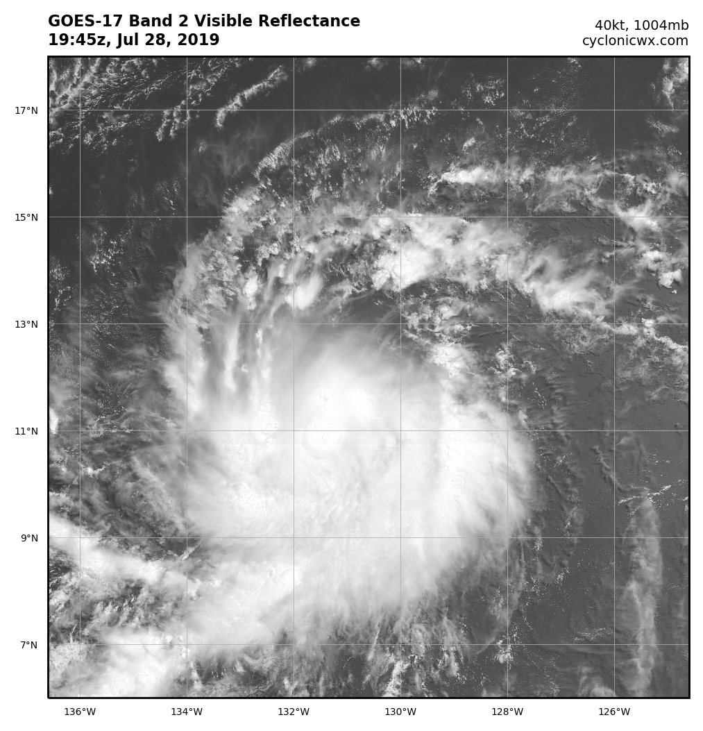
Looking good, but there does appear to be some northerly shear, but nothing too strong
0 likes
This post was probably an opinion of mine, and in no way is official. Please refer to http://www.hurricanes.gov for official tropical analysis and advisories.
My website, with lots of tropical wx graphics, including satellite and recon: http://cyclonicwx.com
My website, with lots of tropical wx graphics, including satellite and recon: http://cyclonicwx.com
-
Kingarabian
- S2K Supporter
- Posts: 16344
- Joined: Sat Aug 08, 2009 3:06 am
- Location: Honolulu, Hawaii
Re: EPAC: ERICK - Tropical Storm
Chris90 wrote:He's looking pretty good, I'd guess he's a 55-60kt storm right now, approaching hurricane intensity. I know I'm way ahead of NHC in my intensity guess, but he's been producing good convection, improving his appearance on microwave images, and if Barry was a hurricane, Erick could definitely be approaching that status.
I'm hoping he can intensify to Cat 3/4 and hold on long enough to get some good recon data, but I'm not holding out hope.
He looks good for sure, probably the best looking Tropical Storm so far. Mid level shear of about 10kts is doing just enough to disrupt the core development process, which is the only reason why it's not a hurricane right now.

But no doubt in my mind that it will be a major hurricane in a day or so.
1 likes
RIP Kobe Bryant
Who is online
Users browsing this forum: No registered users and 4 guests