Tropical Wave SW of Cabo Verde Islands: (Is Invest 96L)

This is the general tropical discussion area. Anyone can take their shot at predicting a storms path.

Moderator: S2k Moderators

Forum rules

The posts in this forum are NOT official forecasts and should not be used as such. They are just the opinion of the poster and may or may not be backed by sound meteorological data. They are NOT endorsed by any professional institution or STORM2K. For official information, please refer to products from the National Hurricane Center and National Weather Service.

Help Support Storm2K
Message
Author
User avatar
cycloneye
Admin
Admin
Posts: 145283
Age: 68
Joined: Thu Oct 10, 2002 10:54 am
Location: San Juan, Puerto Rico

Re: Tropical Wave SW of Cabo Verde Islands

#281 Postby cycloneye » Wed Jul 31, 2019 12:43 pm

A broad area of shower and thunderstorm activity is associated with
a tropical wave located several hundred miles southwest of the Cabo
Verde Islands. Little to no development of the wave is expected for
the next few days while it moves westward across the eastern and
central tropical Atlantic Ocean at about 15 mph. Environmental
conditions are forecast to become more conducive for development
over the weekend and a tropical depression could form by early next
week several hundred miles east of the Lesser Antilles.
* Formation chance through 48 hours...low...near 0 percent.
* Formation chance through 5 days...medium...60 percent.
3 likes   
Visit the Caribbean-Central America Weather Thread where you can find at first post web cams,radars
and observations from Caribbean basin members Click Here

User avatar
abajan
S2K Supporter
S2K Supporter
Posts: 4230
Joined: Sun Sep 07, 2003 5:10 am
Location: Barbados

Re: Tropical Wave SW of Cabo Verde Islands

#282 Postby abajan » Wed Jul 31, 2019 12:48 pm

cycloneye wrote:
A broad area of shower and thunderstorm activity is associated with
a tropical wave located several hundred miles southwest of the Cabo
Verde Islands. Little to no development of the wave is expected for
the next few days while it moves westward across the eastern and
central tropical Atlantic Ocean at about 15 mph. Environmental
conditions are forecast to become more conducive for development
over the weekend and a tropical depression could form by early next
week several hundred miles east of the Lesser Antilles.
* Formation chance through 48 hours...low...near 0 percent.
* Formation chance through 5 days...medium...60 percent.


Thanks. I'm trying to locate the image but can't find it anywhere online as yet.
0 likes   

User avatar
artist
Category 5
Category 5
Posts: 9792
Joined: Mon Jun 06, 2005 3:26 pm
Location: West Palm

Re: Tropical Wave SW of Cabo Verde Islands

#283 Postby artist » Wed Jul 31, 2019 12:52 pm

abajan wrote:
cycloneye wrote:
A broad area of shower and thunderstorm activity is associated with
a tropical wave located several hundred miles southwest of the Cabo
Verde Islands. Little to no development of the wave is expected for
the next few days while it moves westward across the eastern and
central tropical Atlantic Ocean at about 15 mph. Environmental
conditions are forecast to become more conducive for development
over the weekend and a tropical depression could form by early next
week several hundred miles east of the Lesser Antilles.
* Formation chance through 48 hours...low...near 0 percent.
* Formation chance through 5 days...medium...60 percent.


Thanks. I'm trying to locate the image but can't find it anywhere online as yet.


Image


Updated image
Last edited by artist on Wed Jul 31, 2019 1:14 pm, edited 2 times in total.
1 likes   

LarryWx
S2K Supporter
S2K Supporter
Posts: 6302
Joined: Sun Sep 07, 2003 2:04 pm
Location: GA

Re: Tropical Wave SW of Cabo Verde Islands

#284 Postby LarryWx » Wed Jul 31, 2019 12:53 pm

jfk08c wrote:At what longitude do the trade winds start to not have an effect on the westward movement? When does the Bermuda High have to pick the system up and keep it moving west? Still relatively new to the science behind meteorology but to me it seems like the ridging in the Atlantic isn't strong enough to keep the system moving westward after it becomes uninfluenced by the trades. Or is it the trough on the EC that is causing the ridge to move out of the way and letting it recurve? Like I said, still new so if anyone can help me understand what we are looking for i'd greatly appreciate it!


Hi,
1. You need to substitute "westerlies" for "trade winds".
2. I think it is more like the E US trough weakens or keeps weak the western extent of the Atlantic high thus allowing a recurve on the models. But the key words are "on the models". It is still too far out to know if they're right. They may very well be correct as recurves from TCs that have genesis well out in the MDR are significantly more common than non-recurves, even in early August. BUT, we have to watch for the POSSSIBILTY that the model consensus has the E US trough too far east/south since there's a bias. The SE Ridge has often been underdone on model consensus for at least a year.
1 likes   
Personal Forecast Disclaimer:
The posts in this forum are NOT official forecasts and should not be used as such. They are just the opinion of the poster and may or may not be backed by sound meteorological data. They are NOT endorsed by any professional institution or storm2k.org. For official information, please refer to the NHC and NWS products.

User avatar
jfk08c
S2K Supporter
S2K Supporter
Posts: 204
Joined: Mon Jun 11, 2018 4:36 pm
Location: Lakeland, FL

Re: Tropical Wave SW of Cabo Verde Islands

#285 Postby jfk08c » Wed Jul 31, 2019 12:57 pm

LarryWx wrote:
jfk08c wrote:At what longitude do the trade winds start to not have an effect on the westward movement? When does the Bermuda High have to pick the system up and keep it moving west? Still relatively new to the science behind meteorology but to me it seems like the ridging in the Atlantic isn't strong enough to keep the system moving westward after it becomes uninfluenced by the trades. Or is it the trough on the EC that is causing the ridge to move out of the way and letting it recurve? Like I said, still new so if anyone can help me understand what we are looking for i'd greatly appreciate it!


Hi,
1. You need to substitute "westerlies" for "trade winds".
2. I think it is more like the E US trough weakens or keeps weak the western extent of the Atlantic high thus allowing a recurve on the models. But they key words are "on the models". It is still too far out to know if they're right. they may very well be correct and a recurves from TCs that have genesis well out in the MDR are significantly more common than non-recurves, even in early August. BUT, we have to watch for the POSSSIBILTY that the model consensus has the E US trough too far east/south since there's a bias. The SE Ridge has often been underdone on mode consensus for at least a year.


Thanks for the explanation. I know the system is still way too far out to know exactly where its headed, just wasn't sure the exact interaction between the trough and the Atlantic high and what would keep the storm moving west after it exited the area of influence of the "westerlies" lol. Thanks again, great information!
1 likes   

LarryWx
S2K Supporter
S2K Supporter
Posts: 6302
Joined: Sun Sep 07, 2003 2:04 pm
Location: GA

Re: Tropical Wave SW of Cabo Verde Islands

#286 Postby LarryWx » Wed Jul 31, 2019 12:59 pm

jfk08c wrote:
LarryWx wrote:
jfk08c wrote:At what longitude do the trade winds start to not have an effect on the westward movement? When does the Bermuda High have to pick the system up and keep it moving west? Still relatively new to the science behind meteorology but to me it seems like the ridging in the Atlantic isn't strong enough to keep the system moving westward after it becomes uninfluenced by the trades. Or is it the trough on the EC that is causing the ridge to move out of the way and letting it recurve? Like I said, still new so if anyone can help me understand what we are looking for i'd greatly appreciate it!


Hi,
1. You need to substitute "westerlies" for "trade winds".
2. I think it is more like the E US trough weakens or keeps weak the western extent of the Atlantic high thus allowing a recurve on the models. But they key words are "on the models". It is still too far out to know if they're right. they may very well be correct and a recurves from TCs that have genesis well out in the MDR are significantly more common than non-recurves, even in early August. BUT, we have to watch for the POSSSIBILTY that the model consensus has the E US trough too far east/south since there's a bias. The SE Ridge has often been underdone on mode consensus for at least a year.


Thanks for the explanation. I know the system is still way too far out to know exactly where its headed, just wasn't sure the exact interaction between the trough and the Atlantic high and what would keep the storm moving west after it exited the area of influence of the "westerlies" lol. Thanks again, great information!


Ooops, I misread your first post. You were right and me wrong to say substitute westerlies for trade winds. Oy :oops:
0 likes   
Personal Forecast Disclaimer:
The posts in this forum are NOT official forecasts and should not be used as such. They are just the opinion of the poster and may or may not be backed by sound meteorological data. They are NOT endorsed by any professional institution or storm2k.org. For official information, please refer to the NHC and NWS products.

User avatar
NDG
S2K Supporter
S2K Supporter
Posts: 15446
Joined: Sun Jul 09, 2006 10:14 pm
Location: Orlando, FL

Re: Tropical Wave SW of Cabo Verde Islands

#287 Postby NDG » Wed Jul 31, 2019 1:02 pm

I think this still needs a good 48-72 hrs if not closer to 96 hrs to consolidate. IMO.

Image
2 likes   

User avatar
jfk08c
S2K Supporter
S2K Supporter
Posts: 204
Joined: Mon Jun 11, 2018 4:36 pm
Location: Lakeland, FL

Re: Tropical Wave SW of Cabo Verde Islands

#288 Postby jfk08c » Wed Jul 31, 2019 1:03 pm

LarryWx wrote:
Ooops, I misread your first post. You were right and me wrong to say substitute westerlies for trade winds. Oy :oops:


No worries, solid information regardless!
0 likes   

ava_ati
Tropical Storm
Tropical Storm
Posts: 174
Joined: Thu Sep 01, 2016 8:36 am
Location: Saint Augustine

Re: Tropical Wave SW of Cabo Verde Islands

#289 Postby ava_ati » Wed Jul 31, 2019 1:04 pm

Watching the 12z Euro, my eyes are on this upper level feature in the Gulf both models have it, and it appears to have some influence on the GFS on eroding away the ridge once it "hooks-up" with the trough coming across the US

Image
0 likes   

shiny-pebble
Category 1
Category 1
Posts: 299
Joined: Thu Jul 05, 2018 1:38 pm

Re: RE: Re: Tropical Wave SW of Cabo Verde Islands

#290 Postby shiny-pebble » Wed Jul 31, 2019 1:08 pm

artist wrote:Odd, the image still shows 50% but the writeup is at 60%.
The image you posted is from the 8 A.M. outlook

Sent from my LG-H700 using Tapatalk
1 likes   
Not an meteorologist! Just someone who is interested in weather. Please refer to the NHC and local weather officials to make decisions.
-Jack 8-)

User avatar
artist
Category 5
Category 5
Posts: 9792
Joined: Mon Jun 06, 2005 3:26 pm
Location: West Palm

Re: RE: Re: Tropical Wave SW of Cabo Verde Islands

#291 Postby artist » Wed Jul 31, 2019 1:09 pm

shiny-pebble wrote:
artist wrote:Odd, the image still shows 50% but the writeup is at 60%.
The image you posted is from the 8 A.M. outlook

Sent from my LG-H700 using Tapatalk

Oops, didn’t notice that. Guess they posted the outlook before the image. Thanks.
0 likes   

User avatar
abajan
S2K Supporter
S2K Supporter
Posts: 4230
Joined: Sun Sep 07, 2003 5:10 am
Location: Barbados

Re: Tropical Wave SW of Cabo Verde Islands

#292 Postby abajan » Wed Jul 31, 2019 1:10 pm

artist wrote:Odd, the image still shows 50% but the writeup is at 60%.


It took a while to get updated. But it's correct now. Too many S2Kers were bombarding their servers. :D
1 likes   

Aric Dunn
Category 5
Category 5
Posts: 21238
Age: 42
Joined: Sun Sep 19, 2004 9:58 pm
Location: Ready for the Chase.
Contact:

Re: Tropical Wave SW of Cabo Verde Islands

#293 Postby Aric Dunn » Wed Jul 31, 2019 1:31 pm

NDG wrote:I think this still needs a good 48-72 hrs if not closer to 96 hrs to consolidate. IMO.

https://i.imgur.com/Qv851DP.gif


Well it would not take much to consolidate once convection can build. Everything else is there
0 likes   
Note: If I make a post that is brief. Please refer back to previous posts for the analysis or reasoning. I do not re-write/qoute what my initial post said each time.
If there is nothing before... then just ask :)

Space & Atmospheric Physicist, Embry-Riddle Aeronautical University,
I believe the sky is falling...

AutoPenalti
Category 5
Category 5
Posts: 4030
Age: 29
Joined: Mon Aug 17, 2015 4:16 pm
Location: Ft. Lauderdale, Florida

Re: Tropical Wave SW of Cabo Verde Islands

#294 Postby AutoPenalti » Wed Jul 31, 2019 1:35 pm

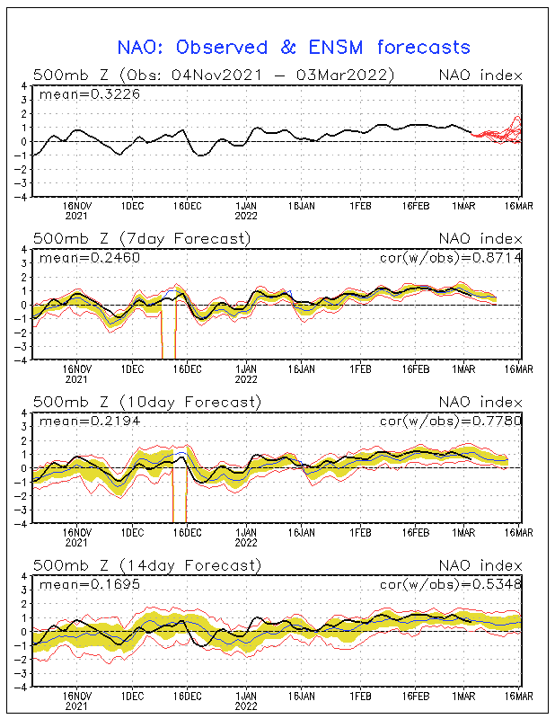
FWIW, NAO tilting to positive by the middle of August.

Image
2 likes   
The posts in this forum are NOT official forecasts and should not be used as such. They are just the opinion of the poster and may or may not be backed by sound meteorological data. They are NOT endorsed by any professional institution or STORM2K. For official information, please refer to products from the NHC and NWS.


Model Runs Cheat Sheet:
GFS (5:30 AM/PM, 11:30 AM/PM)
HWRF, GFDL, UKMET, NAVGEM (6:30-8:00 AM/PM, 12:30-2:00 AM/PM)
ECMWF (1:45 AM/PM)

TCVN
is a weighted averaged

User avatar
NDG
S2K Supporter
S2K Supporter
Posts: 15446
Joined: Sun Jul 09, 2006 10:14 pm
Location: Orlando, FL

Re: Tropical Wave SW of Cabo Verde Islands

#295 Postby NDG » Wed Jul 31, 2019 1:39 pm

12z Euro and GFS are pretty close to each other on its forecasted track through day 7.
12z Euro does not really consolidates its vorticity until at least Sunday night if not Monday morning.
0 likes   

User avatar
GCANE
S2K Supporter
S2K Supporter
Posts: 11496
Joined: Mon Oct 22, 2007 8:03 am

Re: Tropical Wave SW of Cabo Verde Islands

#296 Postby GCANE » Wed Jul 31, 2019 1:43 pm

850mb vort appears to be consolidating and taking a dip to the SW.
0 likes   

TheStormExpert

Re: Tropical Wave SW of Cabo Verde Islands

#297 Postby TheStormExpert » Wed Jul 31, 2019 1:45 pm

AutoPenalti wrote:FWIW, NAO tilting to positive by the middle of August.

https://www.cpc.ncep.noaa.gov/products/precip/CWlink/pna/nao.sprd2.gif

If anything every time the ensembles show the NAO going positive it does but not as much as originally forecasted.
1 likes   

Aric Dunn
Category 5
Category 5
Posts: 21238
Age: 42
Joined: Sun Sep 19, 2004 9:58 pm
Location: Ready for the Chase.
Contact:

Re: Tropical Wave SW of Cabo Verde Islands

#298 Postby Aric Dunn » Wed Jul 31, 2019 1:48 pm

NDG wrote:12z Euro and GFS are pretty close to each other on its forecasted track through day 7.
12z Euro does not really consolidates its vorticity until at least Sunday night if not Monday morning.


8am tomorrow...

Image
0 likes   
Note: If I make a post that is brief. Please refer back to previous posts for the analysis or reasoning. I do not re-write/qoute what my initial post said each time.
If there is nothing before... then just ask :)

Space & Atmospheric Physicist, Embry-Riddle Aeronautical University,
I believe the sky is falling...

TheStormExpert

Re: Tropical Wave SW of Cabo Verde Islands

#299 Postby TheStormExpert » Wed Jul 31, 2019 1:51 pm

Now the Euro kills this in 9 days east of the Bahamas, what good consistency! :lol:
2 likes   

Aric Dunn
Category 5
Category 5
Posts: 21238
Age: 42
Joined: Sun Sep 19, 2004 9:58 pm
Location: Ready for the Chase.
Contact:

Re: Tropical Wave SW of Cabo Verde Islands

#300 Postby Aric Dunn » Wed Jul 31, 2019 1:51 pm

GCANE wrote:850mb vort appears to be consolidating and taking a dip to the SW.


Yeah even with the minimal convection it has had. The surface circ has been able to slowly consolidate. Wont take much convection to really tighten up.
0 likes   
Note: If I make a post that is brief. Please refer back to previous posts for the analysis or reasoning. I do not re-write/qoute what my initial post said each time.
If there is nothing before... then just ask :)

Space & Atmospheric Physicist, Embry-Riddle Aeronautical University,
I believe the sky is falling...


Return to “Talkin' Tropics”

Who is online

Users browsing this forum: kevin and 30 guests