ATL: INVEST 96L - Models
Moderator: S2k Moderators
-
cycloneye

- Admin

- Posts: 149843
- Age: 69
- Joined: Thu Oct 10, 2002 10:54 am
- Location: San Juan, Puerto Rico
ATL: INVEST 96L - Models
Model runs here.
0 likes
Visit the Caribbean-Central America Weather Thread where you can find at first post web cams,radars
and observations from Caribbean basin members Click Here
and observations from Caribbean basin members Click Here
-
CyclonicFury

- Category 5

- Posts: 2040
- Age: 27
- Joined: Sun Jul 02, 2017 12:32 pm
- Location: NC
- Contact:
Re: ATL: INVEST 96L - Models
* ATLANTIC 2019 SHIPS INTENSITY FORECAST *
* IR SAT DATA AVAILABLE, OHC AVAILABLE *
* INVEST AL962019 08/01/19 00 UTC *
TIME (HR) 0 6 12 18 24 36 48 60 72 84 96 108 120
V (KT) NO LAND 25 26 27 28 30 36 42 50 60 67 74 79 81
V (KT) LAND 25 26 27 28 30 36 42 50 60 67 74 79 81
V (KT) LGEM 25 25 25 26 26 28 30 34 41 49 58 67 72
Storm Type TROP TROP TROP TROP TROP TROP TROP TROP TROP TROP TROP TROP TROP
SHEAR (KT) 22 16 16 16 13 7 5 8 4 9 6 11 15
SHEAR ADJ (KT) -11 -7 -6 -5 -5 1 -2 -5 -3 -3 -3 -2 -1
SHEAR DIR 96 94 66 63 51 13 351 354 38 8 301 318 286
SST (C) 27.7 27.7 27.8 27.9 27.8 27.6 27.4 26.5 26.7 27.2 27.5 28.0 28.1
POT. INT. (KT) 133 133 133 134 133 132 130 119 121 127 131 138 139
ADJ. POT. INT. 133 133 132 132 133 132 129 116 118 124 128 137 136
200 MB T (C) -53.4 -53.5 -53.2 -53.0 -53.1 -53.0 -53.6 -53.9 -53.8 -53.9 -53.6 -54.0 -53.7
200 MB VXT (C) 0.0 -0.1 -0.2 -0.3 -0.3 -0.6 -0.3 -0.1 -0.1 -0.2 -0.1 0.0 0.1
TH_E DEV (C) 4 4 4 4 5 5 5 5 5 6 7 8 8
700-500 MB RH 72 69 65 63 60 60 61 63 69 65 65 63 61
MODEL VTX (KT) 11 12 12 11 11 11 9 9 11 12 14 14 14
850 MB ENV VOR 57 65 65 56 54 43 19 2 6 13 13 7 15
200 MB DIV 38 8 -17 -30 -46 -75 -10 6 18 -1 3 10 30
700-850 TADV 0 0 -2 -1 -3 -2 -1 0 -2 -3 -5 -5 -6
LAND (KM) 1803 1696 1590 1515 1444 1309 1236 1190 1130 1060 1032 844 719
LAT (DEG N) 9.6 9.4 9.3 9.2 9.4 10.3 11.7 12.9 13.7 14.2 14.8 15.4 16.3
LONG(DEG W) 35.7 36.7 37.7 38.4 39.2 41.1 43.1 45.2 47.2 49.6 52.1 54.8 57.5
STM SPEED (KT) 11 10 8 7 9 12 12 11 11 12 13 14 13
HEAT CONTENT 10 11 13 17 20 22 13 11 11 8 14 44 34
0 likes
NCSU B.S. in Meteorology Class of 2021. Tropical weather blogger at http://www.cyclonicfury.com. My forecasts and thoughts are NOT official, for official forecasts please consult the National Hurricane Center.
-
Kingarabian

- S2K Supporter

- Posts: 16384
- Joined: Sat Aug 08, 2009 3:06 am
- Location: Honolulu, Hawaii
Re: ATL: INVEST 96L - Models
18z Euro close to 18z GFS and 12z Euro thriugh hour 90.
0 likes
RIP Kobe Bryant
-
cycloneye
- Admin
- Posts: 149843
- Age: 69
- Joined: Thu Oct 10, 2002 10:54 am
- Location: San Juan, Puerto Rico
Re: ATL: INVEST 96L - Models
Kingarabian wrote:18z Euro close to 18z GFS and 12z Euro thriugh hour 90.
Do you have a graphic?
0 likes
Visit the Caribbean-Central America Weather Thread where you can find at first post web cams,radars
and observations from Caribbean basin members Click Here
and observations from Caribbean basin members Click Here

-
TheStormExpert


-
gatorcane

- S2K Supporter
- Posts: 23708
- Age: 48
- Joined: Sun Mar 13, 2005 3:54 pm
- Location: Boca Raton, FL
Re: ATL: INVEST 96L - Models
USTropics wrote:18z GFS ensemble members:
https://i.ibb.co/cYk0GXd/gfs-ememb-lowlocs-atl-fh120-288.gif
Notice some of those ensembles do not recurve and head over Florida or recurve very near Florida like the 18Z GFS legacy. First time we see some ensembles doing that.
0 likes
-
Kingarabian
- S2K Supporter
- Posts: 16384
- Joined: Sat Aug 08, 2009 3:06 am
- Location: Honolulu, Hawaii
Re: ATL: INVEST 96L - Models
cycloneye wrote:Kingarabian wrote:18z Euro close to 18z GFS and 12z Euro thriugh hour 90.
Do you have a graphic?
This graphic shows an organized vort although we'll need to wait for the 12z Euro to see if it means anything.

PC: Weathermodels.com
1 likes
RIP Kobe Bryant
-
USTropics
- Professional-Met

- Posts: 2742
- Joined: Sun Aug 12, 2007 3:45 am
- Location: Florida State University
Re: ATL: INVEST 96L - Models
GFS ensemble 500mb trend - past 4 runs (much shallower trough displaced to the NE):

2 likes
-
floridasun78
- Category 5
- Posts: 3755
- Joined: Sun May 17, 2009 10:16 pm
- Location: miami fl
-
AutoPenalti
- Category 5
- Posts: 4091
- Age: 29
- Joined: Mon Aug 17, 2015 4:16 pm
- Location: Ft. Lauderdale, Florida
Re: ATL: INVEST 96L - Models
That’s one hell of a shallow trough. It’s cutting it close.
1 likes
The posts in this forum are NOT official forecasts and should not be used as such. They are just the opinion of the poster and may or may not be backed by sound meteorological data. They are NOT endorsed by any professional institution or STORM2K. For official information, please refer to products from the NHC and NWS.
Model Runs Cheat Sheet:
GFS (5:30 AM/PM, 11:30 AM/PM)
HWRF, GFDL, UKMET, NAVGEM (6:30-8:00 AM/PM, 12:30-2:00 AM/PM)
ECMWF (1:45 AM/PM)
TCVN is a weighted averaged
-
Hurricaneman

- Category 5
- Posts: 7404
- Age: 45
- Joined: Tue Aug 31, 2004 3:24 pm
- Location: central florida
Re: ATL: INVEST 96L - Models
AutoPenalti wrote:That’s one hell of a shallow trough. It’s cutting it close.
I’m in Clermont Fl and I’m watching this like a hawk as the trend is toward Florida and the SEUS and this could be anything from TS to cat 3 or 4 hurricane according to the models so interesting days ahead
1 likes
-
floridasun78
- Category 5
- Posts: 3755
- Joined: Sun May 17, 2009 10:16 pm
- Location: miami fl
-
CrazyC83
- Professional-Met
- Posts: 34316
- Joined: Tue Mar 07, 2006 11:57 pm
- Location: Deep South, for the first time!
Re: ATL: INVEST 96L - Models
This is one we will likely be watching for a while. Although we have a long way to go.
0 likes

Re: ATL: INVEST 96L - Models
During the last couple of days I have been looking at the pattern so far this summer week by week across the eastern US and SW Atlantic it has been kind of mix bag, though it has been a persistent -NAO it has not been a deep trough pattern all the time across the eastern US and SW Atlantic. In fact the over all pattern so far this July has been above average ridging across the GLs & NE US, which makes sense because northern Europe's weather has also been visited by ridging giving them a couple of record breaking heat waves, it has not been your typical -NAO pattern. Where it has been below average heights is across the southern US.
Yes, troughs have come down but have lifted up and ridging has taken over the NE US, but heights have stayed below average across the southern US after the trough lifts. It will all depend on timing when these troughs come down over the next 7-10 days as to whether 96L goes out to sea well east of the US or if it could become a threat to the eastern US.
Yes, troughs have come down but have lifted up and ridging has taken over the NE US, but heights have stayed below average across the southern US after the trough lifts. It will all depend on timing when these troughs come down over the next 7-10 days as to whether 96L goes out to sea well east of the US or if it could become a threat to the eastern US.
1 likes
-
CyclonicFury
- Category 5
- Posts: 2040
- Age: 27
- Joined: Sun Jul 02, 2017 12:32 pm
- Location: NC
- Contact:
Re: ATL: INVEST 96L - Models
00Z GFS much faster with development. 1010 mb TS at hour 84.
0 likes
NCSU B.S. in Meteorology Class of 2021. Tropical weather blogger at http://www.cyclonicfury.com. My forecasts and thoughts are NOT official, for official forecasts please consult the National Hurricane Center.
-
Hurricaneman
- Category 5
- Posts: 7404
- Age: 45
- Joined: Tue Aug 31, 2004 3:24 pm
- Location: central florida
Re: ATL: INVEST 96L - Models
CyclonicFury wrote:00Z GFS much faster with development. 1010 mb TS at hour 84.
And farther south
0 likes
-
Evil Jeremy

- S2K Supporter
- Posts: 5463
- Age: 32
- Joined: Mon Apr 10, 2006 2:10 pm
- Location: Los Angeles, CA
Re: ATL: INVEST 96L - Models
CyclonicFury wrote:00Z GFS much faster with development. 1010 mb TS at hour 84.
At 144 hours, it's farther south than any run in the past 6 cycles. Going to go south of PR looks like.
1 likes
Frances 04 / Jeanne 04 / Katrina 05 / Wilma 05 / Fay 08 / Debby 12 / Andrea 13 / Colin 16 / Hermine 16 / Matthew 16 / Irma 17
-
USTropics
- Professional-Met
- Posts: 2742
- Joined: Sun Aug 12, 2007 3:45 am
- Location: Florida State University
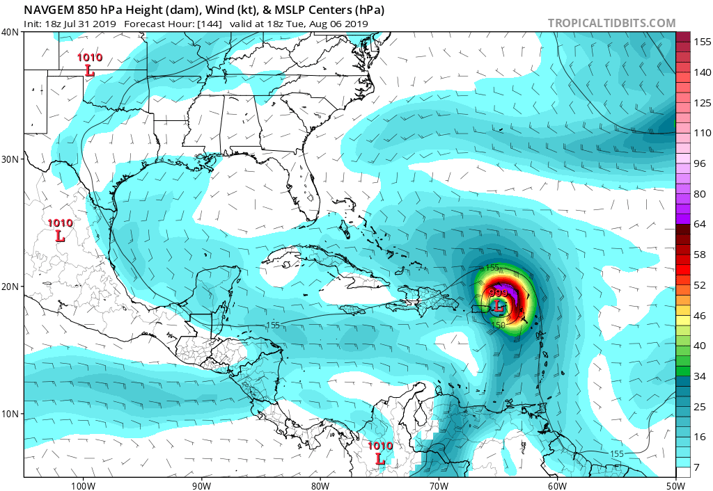
Re: ATL: INVEST 96L - Models
Evil Jeremy wrote:CyclonicFury wrote:00Z GFS much faster with development. 1010 mb TS at hour 84.
At 144 hours, it's farther south than any run in the past 6 cycles. Going to go south of PR looks like.
Skirts western PR and looks to make landfall in eastern Hispaniola, quite a big shift south (very tiny core too):

0 likes
Who is online
Users browsing this forum: No registered users and 42 guests