ATL: INVEST 96L - Models
Moderator: S2k Moderators

Re: ATL: INVEST 96L - Models
06z gfs continues the trend of no development.
0 likes
Kendall -> SLO -> PBC
Memorable Storms: Katrina (for its Florida landfall...) Wilma Matthew Irma
Memorable Storms: Katrina (for its Florida landfall...) Wilma Matthew Irma
-
gatorcane

- S2K Supporter

- Posts: 23708
- Age: 48
- Joined: Sun Mar 13, 2005 3:54 pm
- Location: Boca Raton, FL
Re: ATL: INVEST 96L - Models
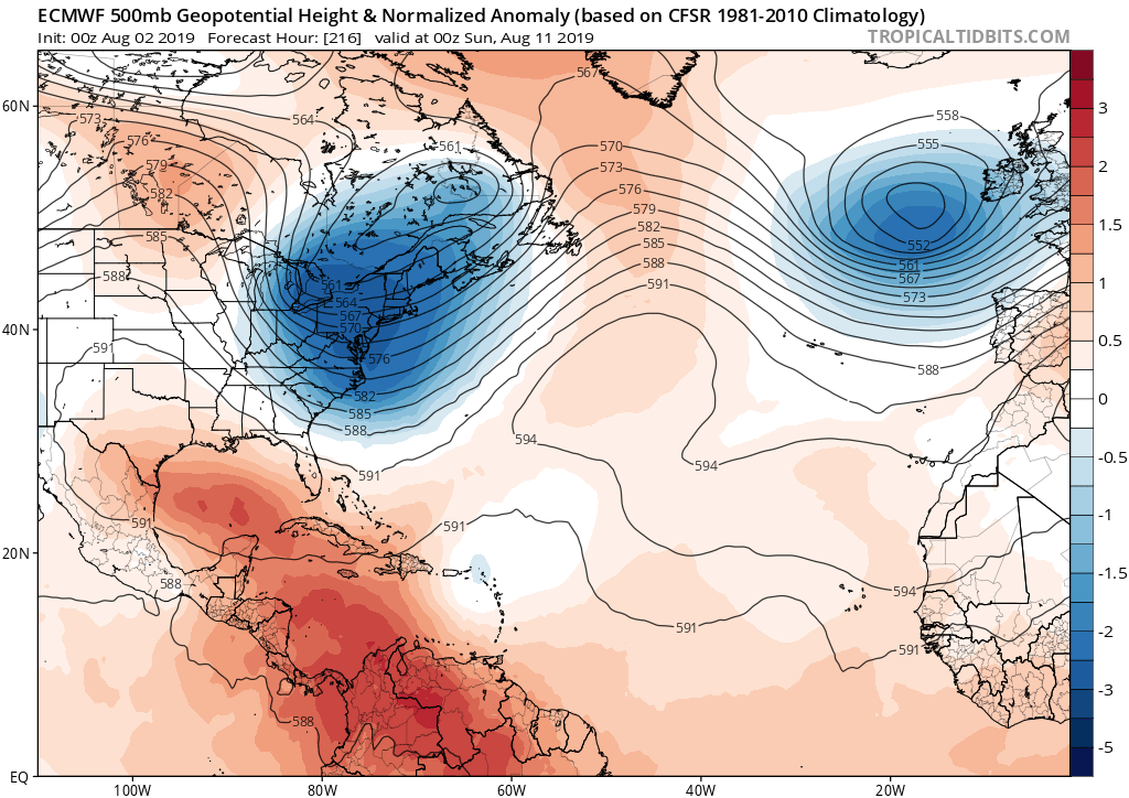
Looks like even if 96l were to have developed into a hurricane near the Bahamas like the models thought a couple of days ago, recurve away from US would probably have been the outcome. For example, look at that deep East Coast trough on the ECMWF:
0 likes
-
SFLcane

- S2K Supporter
- Posts: 10281
- Age: 48
- Joined: Sat Jun 05, 2010 1:44 pm
- Location: Lake Worth Florida
Re: ATL: INVEST 96L - Models
gatorcane wrote:Looks like even if 96l were to have developed into a hurricane near the Bahamas like the models thought a couple of days ago, recurve away from US would probably have been the outcome. For example, look at that deep East Coast trough on the ECMWF:
https://i.postimg.cc/DzyNmVwW/ecmwf-z500a-Norm-atl-10.png
Hey Gator, indeed! Nothing will come close with that December like trof in place.
0 likes
-
wxman57

- Moderator-Pro Met

- Posts: 23172
- Age: 68
- Joined: Sat Jun 21, 2003 8:06 pm
- Location: Houston, TX (southwest)
Re: ATL: INVEST 96L - Models
Development chances over the next 3-4 days look close to zero. Even if it can escape the giant dust cloud it's embedded within, it'll run into high shear as it nears the Caribbean. Only shot at development would be after it passes east of the Bahamas and is recurving to the NE and out to sea.

5 likes
-
northjaxpro

- S2K Supporter
- Posts: 8900
- Joined: Mon Sep 27, 2010 11:21 am
- Location: Jacksonville, FL
Re: ATL: INVEST 96L - Models
The -NAO , if it continues to linger, could save us and spare many from tropical cyclone impacts here especially the Southeast U.S. and much of the CONUS Eastern Seaboard.
1 likes
NEVER, EVER SAY NEVER in the tropics and weather in general, and most importantly, with life itself!!
________________________________________________________________________________________
Fay 2008 Beryl 2012 Debby 2012 Colin 2016 Hermine 2016 Julia 2016 Matthew 2016 Irma 2017 Dorian 2019
________________________________________________________________________________________
Fay 2008 Beryl 2012 Debby 2012 Colin 2016 Hermine 2016 Julia 2016 Matthew 2016 Irma 2017 Dorian 2019
-
AutoPenalti
- Category 5

- Posts: 4091
- Age: 29
- Joined: Mon Aug 17, 2015 4:16 pm
- Location: Ft. Lauderdale, Florida
Re: ATL: INVEST 96L - Models
northjaxpro wrote::uarrow: -NAO still going strong, as has been the case for much of this Summer.
The -NAO , if it continues to linger, could save us and spare many from tropical cyclone impacts here especially the Southeast U.S. and much of the CONUS Eastern Seaboard.
NAO is forecast to go positive by the middle of August.
0 likes
The posts in this forum are NOT official forecasts and should not be used as such. They are just the opinion of the poster and may or may not be backed by sound meteorological data. They are NOT endorsed by any professional institution or STORM2K. For official information, please refer to products from the NHC and NWS.
Model Runs Cheat Sheet:
GFS (5:30 AM/PM, 11:30 AM/PM)
HWRF, GFDL, UKMET, NAVGEM (6:30-8:00 AM/PM, 12:30-2:00 AM/PM)
ECMWF (1:45 AM/PM)
TCVN is a weighted averaged
-
TheStormExpert
Re: ATL: INVEST 96L - Models
AutoPenalti wrote:northjaxpro wrote::uarrow: -NAO still going strong, as has been the case for much of this Summer.
The -NAO , if it continues to linger, could save us and spare many from tropical cyclone impacts here especially the Southeast U.S. and much of the CONUS Eastern Seaboard.
NAO is forecast to go positive by the middle of August.
Not anymore.

1 likes

Re: ATL: INVEST 96L - Models
wxman57 wrote:Development chances over the next 3-4 days look close to zero. Even if it can escape the giant dust cloud it's embedded within, it'll run into high shear as it nears the Caribbean. Only shot at development would be after it passes east of the Bahamas and is recurving to the NE and out to sea.
http://wxman57.com/images/96L.JPG
A lot of that area you circled is makes it look like the dust is much larger than what it is, probably because of the sun's reflections from its angle being early in the morning.
According to this image the dust is not that extensive, but 96L has definitely sucked some of that dust into its circulation. Mid level dry air is another subject is definitely large over the middle of the Atlantic Ocean.

3 likes

Re: ATL: INVEST 96L - Models
People in St Maarten collectively breathing sighs of relief! PTSD is real! 

10 likes
Too many hurricanes to remember
-
CyclonicFury

- Category 5
- Posts: 2032
- Age: 27
- Joined: Sun Jul 02, 2017 12:32 pm
- Location: NC
- Contact:
Re: ATL: INVEST 96L - Models
The 12z ECMWF shows 96L a bit more defined than the last three runs as it approaches the Lesser Antilles.
0 likes
NCSU B.S. in Meteorology Class of 2021. Tropical weather blogger at http://www.cyclonicfury.com. My forecasts and thoughts are NOT official, for official forecasts please consult the National Hurricane Center.
-
Dylan

- Professional-Met

- Posts: 338
- Age: 31
- Joined: Mon May 31, 2010 9:50 am
- Location: New Orleans, LA
Re: ATL: INVEST 96L - Models
0 likes
Georges('98), Allison('01), Isidore('02), Lili('02), Frances('04) Ivan('04), Cindy('05), Katrina('05), Rita('05), Gustav('08), Isaac('12), Matthew('16), Harvey('17), Irma('17), Nate ('17), Ida ('21).

Re: ATL: INVEST 96L - Models
6z GFS looks like it splits the wave and keeps the southern vorticity fairly strong:

3 likes


Re: ATL: INVEST 96L - Models
N2FSU wrote:6z GFS looks like it splits the wave and keeps the southern vorticity fairly strong:
https://lh3.googleusercontent.com/aUmoTvaxeN1zQcQvXLcGZuNdRR6xP0fB1SGveGkRlI1d5InWp1eLWJpuUkSDCkCsWlmcSJ2nD81kbewvKiCSpBtNIXrWKVBcBLO-IpbKTklCI2vXExqWpoINRtKMpwaokocEe2QHz18=w2400
Yeah it’s been oscillating back in forth between which lobe would be stronger since it dropped significant development. Reminds me of Harvey and PTC10 or whatever it was which were supposed to be two halves of a merged system but eventually split with Harvey becoming a weak Caribbean cruiser that degenerated soon after the Lesser Antilles.
3 likes
-
Hurricaneman

- Category 5
- Posts: 7404
- Age: 45
- Joined: Tue Aug 31, 2004 3:24 pm
- Location: central florida
Re: ATL: INVEST 96L - Models
It looks as though the GFS has the right idea as it seems to be developing at 12N unlike the EURO which has it at 15N which would be better for this system as it stays south of the TUTT and might just develop in the western Caribbean
0 likes
-
Emmett_Brown

- Category 5
- Posts: 1433
- Joined: Wed Aug 24, 2005 9:10 pm
- Location: Sarasota FL
Re: ATL: INVEST 96L - Models
12Z GFS showing a weak vort max associated with 96L approaching Jamaica by next Thursday... so a chance 96L continues W and makes it into the W Caribbean. However, GFS also predicting westerly wind shear to develop in that area, which dissipates 96L.
0 likes
Re: ATL: INVEST 96L - Models
18z GFS has the same Caribbean idea, good vorticity at first but then it moves straight into the shear


0 likes
-
Hurricaneman
- Category 5
- Posts: 7404
- Age: 45
- Joined: Tue Aug 31, 2004 3:24 pm
- Location: central florida
Re: ATL: INVEST 96L - Models
Visioen wrote:18z GFS has the same Caribbean idea, good vorticity at first but then it moves straight into the shear
https://i.imgur.com/yR0neMH.png
https://i.imgur.com/JejwOSR.png
Looks very El Niño with those westerlies through the Caribbean
1 likes
-
AxaltaRacing24
- Category 5
- Posts: 1774
- Age: 25
- Joined: Wed Jul 27, 2016 11:14 am
- Location: Jupiter, FL
Re: ATL: INVEST 96L - Models
Hurricaneman wrote:Visioen wrote:18z GFS has the same Caribbean idea, good vorticity at first but then it moves straight into the shear
https://i.imgur.com/yR0neMH.png
https://i.imgur.com/JejwOSR.png
Looks very El Niño with those westerlies through the Caribbean
it's just typical for that area so far man. even 2017 killed harvey in that area in mid to late august and caused everybody to scream season cancel. give it 3 weeks.
8 likes
Who is online
Users browsing this forum: No registered users and 50 guests