

18z GFS has a low pressure area popping out into the Southwest GOM
Moderator: S2k Moderators


USTropics wrote:Area of genesis from the past 2/3 very-long range GFS runs can be tracked from this currently tilted AEW heading WSW (expected to depart the African coast on Sunday):
https://i.imgur.com/hdN30sR.jpg
I've shrewdly highlighted the wave axis below as it progresses through the Atlantic:
https://i.ibb.co/82HBFhB/Webp-net-gifmaker-2.gif
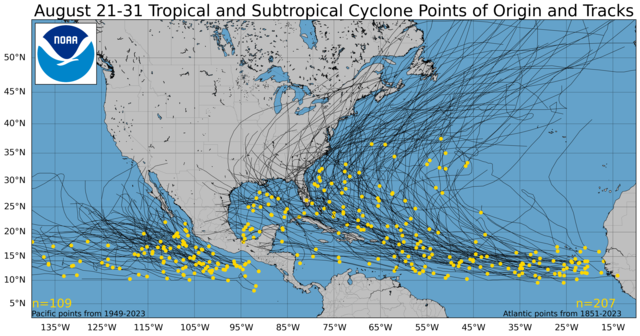
Climatology speaking, the WGOM/BOC is a prime spot for development in the last 10 days of August:
https://www.nhc.noaa.gov/climo/images/aug_21_31_sm.png


Ubuntwo wrote:The 0z legacy picks up on this too
Ubuntwo wrote:https://i.imgur.com/AViPBGG.png
Hurricane! Let's see if it persists in future runs
Hurricaneman wrote:Ubuntwo wrote:https://i.imgur.com/AViPBGG.png
Hurricane! Let's see if it persists in future runs
Have to watch this in future runs, hurricanes that formed in this area from frontal means are
Diana 1984
Carol 1954
Bob 1991
Belle 1976
The thing that’s interesting is that this is the area that the GFS developed 3 or 4 days ago in its runs although farther NE


Users browsing this forum: AnnularCane, cycloneye, Google Adsense [Bot] and 75 guests

