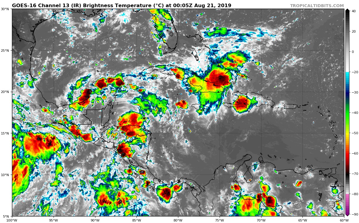
Area in the Bahamas: Is Invest 98L

This is the general tropical discussion area. Anyone can take their shot at predicting a storms path.

Moderator: S2k Moderators

Forum rules

The posts in this forum are NOT official forecasts and should not be used as such. They are just the opinion of the poster and may or may not be backed by sound meteorological data. They are NOT endorsed by any professional institution or STORM2K. For official information, please refer to products from the National Hurricane Center and National Weather Service.

Help Support Storm2K
Message
Author
User avatar
boca
Category 5
Category 5
Posts: 6367
Age: 60
Joined: Mon Dec 15, 2003 8:49 am
Location: Boca Raton,FL

Re: Area in the Bahamas

#41 Postby boca » Tue Aug 20, 2019 5:20 pm

Hurricaneman wrote:
Aric Dunn wrote:
Hurricaneman wrote:Actually I believe that’s the Caribbean system, this system is near the Florida east coast


no you can follow it. the carrib wave is already in western gulf by then.


nothing come from it.

I see it now, I do believe that this is as far west this can go with that setup, expecting it to not quite make it that far west


How far west do you think this will go?
0 likes   

User avatar
Hurricaneman
Category 5
Category 5
Posts: 7351
Age: 45
Joined: Tue Aug 31, 2004 3:24 pm
Location: central florida

Re: Area in the Bahamas

#42 Postby Hurricaneman » Tue Aug 20, 2019 5:38 pm

boca wrote:
Hurricaneman wrote:
Aric Dunn wrote:
no you can follow it. the carrib wave is already in western gulf by then.


nothing come from it.

I see it now, I do believe that this is as far west this can go with that setup, expecting it to not quite make it that far west


How far west do you think this will go?

It seems to split in 2 pieces the one in the central GOM and an area east of Florida so looking at things my thought is just off the Florida east coast kind of drifting around before a trough in about 8 days picks it up and brushes by the Carolinas on its way to Nova Scotia but as always this could and probably will change
0 likes   

floridasun78
Category 5
Category 5
Posts: 3755
Joined: Sun May 17, 2009 10:16 pm
Location: miami fl

Re: Area in the Bahamas

#43 Postby floridasun78 » Tue Aug 20, 2019 6:29 pm

miami weather office do talk about tropical wave coming by friday https://forecast.weather.gov/product.ph ... glossary=0
0 likes   

User avatar
Nimbus
Category 5
Category 5
Posts: 5300
Joined: Mon Jul 19, 2004 10:54 am

Re: Area in the Bahamas

#44 Postby Nimbus » Tue Aug 20, 2019 6:30 pm

There was a vortex visible just east of Andros island at sunset, but I haven't checked the buoys for surface pressure.
0 likes   

User avatar
northjaxpro
S2K Supporter
S2K Supporter
Posts: 8900
Joined: Mon Sep 27, 2010 11:21 am
Location: Jacksonville, FL

Re: Area in the Bahamas

#45 Postby northjaxpro » Tue Aug 20, 2019 6:43 pm

Nimbus wrote:There was a vortex visible just east of Andros island at sunset, but I haven't checked the buoys for surface pressure.


Pressures are in the 1015 -1016 range currently, but with the redevelopment of deep convection in the area near and north of the coast of Cuba, into the Central Bahamas late today into this evening, I am expecting pressures to gradually fall off .

I agree the NHC should tag this as an invest shortly as there is sufficient model support now.
1 likes   
NEVER, EVER SAY NEVER in the tropics and weather in general, and most importantly, with life itself!!

________________________________________________________________________________________

Fay 2008 Beryl 2012 Debby 2012 Colin 2016 Hermine 2016 Julia 2016 Matthew 2016 Irma 2017 Dorian 2019

Aric Dunn
Category 5
Category 5
Posts: 21238
Age: 42
Joined: Sun Sep 19, 2004 9:58 pm
Location: Ready for the Chase.
Contact:

Re: Area in the Bahamas

#46 Postby Aric Dunn » Tue Aug 20, 2019 7:48 pm

18z Euro. 51 hours.

then slow development over 90hrs. but spends time over florida. has the vorticity increasing a lot in the next 24 hours.

Image
1 likes   
Note: If I make a post that is brief. Please refer back to previous posts for the analysis or reasoning. I do not re-write/qoute what my initial post said each time.
If there is nothing before... then just ask :)

Space & Atmospheric Physicist, Embry-Riddle Aeronautical University,
I believe the sky is falling...

User avatar
gatorcane
S2K Supporter
S2K Supporter
Posts: 23691
Age: 47
Joined: Sun Mar 13, 2005 3:54 pm
Location: Boca Raton, FL

Re: Area in the Bahamas

#47 Postby gatorcane » Tue Aug 20, 2019 8:24 pm

12Z UKMET with weak development in SE GOM:

Image
1 likes   

User avatar
northjaxpro
S2K Supporter
S2K Supporter
Posts: 8900
Joined: Mon Sep 27, 2010 11:21 am
Location: Jacksonville, FL

Re: Area in the Bahamas

#48 Postby northjaxpro » Tue Aug 20, 2019 8:27 pm

OK. So now the UKMET is now on board with the EURO and GFS for development. The Big 3 all have it now.

Should see this declared an invest by tomorrow.
Last edited by northjaxpro on Tue Aug 20, 2019 8:32 pm, edited 1 time in total.
1 likes   
NEVER, EVER SAY NEVER in the tropics and weather in general, and most importantly, with life itself!!

________________________________________________________________________________________

Fay 2008 Beryl 2012 Debby 2012 Colin 2016 Hermine 2016 Julia 2016 Matthew 2016 Irma 2017 Dorian 2019

User avatar
gatorcane
S2K Supporter
S2K Supporter
Posts: 23691
Age: 47
Joined: Sun Mar 13, 2005 3:54 pm
Location: Boca Raton, FL

Re: Area in the Bahamas

#49 Postby gatorcane » Tue Aug 20, 2019 8:31 pm

Convection is sheared but seems to be persisting. I agree maybe an invest should be declared. This system kindaof fell of the radar but bears watching:

https://www.tropicaltidbits.com/sat/sat ... product=ir

Image
2 likes   

psyclone
S2K Supporter
S2K Supporter
Posts: 4762
Joined: Wed Aug 24, 2005 9:04 pm
Location: palm harbor fl

Re: Area in the Bahamas

#50 Postby psyclone » Tue Aug 20, 2019 9:11 pm

Proximity, the calendar and a lack of much else has me intrigued with this. convection has been rather tenacious.
1 likes   

floridasun78
Category 5
Category 5
Posts: 3755
Joined: Sun May 17, 2009 10:16 pm
Location: miami fl

Re: Area in the Bahamas

#51 Postby floridasun78 » Tue Aug 20, 2019 9:15 pm

it may takes days to get invest nhc not in hurry to put invest in area their need few days models runs
1 likes   

User avatar
toad strangler
S2K Supporter
S2K Supporter
Posts: 4543
Joined: Sun Jul 28, 2013 3:09 pm
Location: Earth
Contact:

Re: Area in the Bahamas

#52 Postby toad strangler » Tue Aug 20, 2019 9:43 pm

floridasun78 wrote:it may takes days to get invest nhc not in hurry to put invest in area their need few days models runs


The NHC doesn’t hug models like that my friend.
0 likes   

floridasun78
Category 5
Category 5
Posts: 3755
Joined: Sun May 17, 2009 10:16 pm
Location: miami fl

Re: Area in the Bahamas

#53 Postby floridasun78 » Tue Aug 20, 2019 9:43 pm

here pic of bahamas radar coming down good southern bahamas http://smartmet.bahamasweather.org.bs/radarcomposite/
0 likes   

User avatar
Hurricaneman
Category 5
Category 5
Posts: 7351
Age: 45
Joined: Tue Aug 31, 2004 3:24 pm
Location: central florida

Re: Area in the Bahamas

#54 Postby Hurricaneman » Tue Aug 20, 2019 11:01 pm

The 0zGFS seems to show a wave split where the southern part goes into the GOM while the northern part meanders east of Florida, this may be a very complicated system and could be a problem for someone along the east coast from Florida to Nova Scotia so this needs to be watched
1 likes   

USTropics
Professional-Met
Professional-Met
Posts: 2650
Joined: Sun Aug 12, 2007 3:45 am
Location: Florida State University

Re: Area in the Bahamas

#55 Postby USTropics » Wed Aug 21, 2019 1:56 am

The vorticity from this area can be tracked moving over Fl and then up the east coast on the 00z ECMWF operational, strengthening into a hurricane as it moves north (similar genesis as Chantal):

Image
0 likes   

USTropics
Professional-Met
Professional-Met
Posts: 2650
Joined: Sun Aug 12, 2007 3:45 am
Location: Florida State University

Re: Area in the Bahamas

#56 Postby USTropics » Wed Aug 21, 2019 2:35 am

00z UKMET on board with development:
Image
0 likes   

User avatar
GCANE
S2K Supporter
S2K Supporter
Posts: 11496
Joined: Mon Oct 22, 2007 8:03 am

Re: Area in the Bahamas

#57 Postby GCANE » Wed Aug 21, 2019 3:34 am

A small 850mb vort is starting to show up on the north shore of Cuba

Image
0 likes   

User avatar
GCANE
S2K Supporter
S2K Supporter
Posts: 11496
Joined: Mon Oct 22, 2007 8:03 am

Re: Area in the Bahamas

#58 Postby GCANE » Wed Aug 21, 2019 3:36 am

700mb vort is well defined

Image
0 likes   

User avatar
GCANE
S2K Supporter
S2K Supporter
Posts: 11496
Joined: Mon Oct 22, 2007 8:03 am

Re: Area in the Bahamas

#59 Postby GCANE » Wed Aug 21, 2019 4:08 am

Shear clears out in about 36 hrs.
1 likes   

Aric Dunn
Category 5
Category 5
Posts: 21238
Age: 42
Joined: Sun Sep 19, 2004 9:58 pm
Location: Ready for the Chase.
Contact:

Re: Area in the Bahamas

#60 Postby Aric Dunn » Wed Aug 21, 2019 5:14 am

Model support keeps increasing
1 likes   
Note: If I make a post that is brief. Please refer back to previous posts for the analysis or reasoning. I do not re-write/qoute what my initial post said each time.
If there is nothing before... then just ask :)

Space & Atmospheric Physicist, Embry-Riddle Aeronautical University,
I believe the sky is falling...


Return to “Talkin' Tropics”

Who is online

Users browsing this forum: Europa non è lontana, StormWeather and 35 guests