000
WTNT44 KNHC 210835
TCDAT4
Tropical Storm Chantal Discussion Number 2
NWS National Hurricane Center Miami FL AL042019
500 AM AST Wed Aug 21 2019
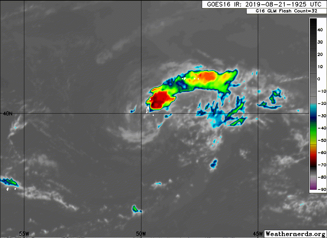
Chantal has changed little overnight. A small area of deep
convection has persisted northeast of the tropical storm's exposed
surface center. Given the steady-state structure of the cyclone, the
initial intensity has been held at 35 kt based on earlier ASCAT
data.
Only minor adjustments were made to the NHC track and intensity
forecasts, the most substantial of which is that Chantal is now
expected to become a remnant low within 96 h. The tropical storm is
surrounded by dry air and will be moving over marginal SSTs for the
next couple of days. As a result of this unfavorable environment,
Chantal is expected to weaken to a tropical depression by 48 h. Most
of the dynamical models indicate that the cyclone will lose all of
its convection and become post-tropical soon after, but the official
forecast conservatively maintains the system as a tropical cyclone
for 72 h. The official intensity forecast is near a consensus of the
GFS, HMON, and HWRF models.
The tropical storm is moving quickly eastward, but is forecast to
slow and turn southeastward by Thursday. It should then turn toward
the south on Friday as it moves around the northeast periphery of a
low- to mid-level ridge centered over the central Atlantic. The
track guidance is in good agreement on the forecast, at least as
long as Chantal remains a tropical cyclone. The uncertainty in the
track forecast is higher after the cyclone becomes a remnant low,
but most of the guidance generally suggests that Chantal will become
trapped in weak steering flow and meander over the North Atlantic
for a couple days thereafter.
FORECAST POSITIONS AND MAX WINDS
INIT 21/0900Z 40.3N 53.7W 35 KT 40 MPH
12H 21/1800Z 40.2N 50.4W 35 KT 40 MPH
24H 22/0600Z 39.6N 46.3W 35 KT 40 MPH
36H 22/1800Z 38.4N 43.4W 35 KT 40 MPH
48H 23/0600Z 37.2N 42.0W 30 KT 35 MPH
72H 24/0600Z 35.3N 42.4W 30 KT 35 MPH
96H 25/0600Z 35.5N 44.0W 30 KT 35 MPH...POST-TROP/REMNT LOW
120H 26/0600Z 37.5N 44.0W 30 KT 35 MPH...POST-TROP/REMNT LOW
$$
Forecaster Zelinsky
ATL: CHANTAL - Remnants
Moderator: S2k Moderators
-
Sciencerocks
- Category 5

- Posts: 10181
- Age: 40
- Joined: Thu Jul 06, 2017 1:51 am
-
plasticup
Re: ATL: CHANTAL - Tropical Storm - Discussion
Hammy wrote:Was this the same system that was an X over NW Florida like a week ago?
Yep! Developed a lot later than we all expected, but here it is.
1 likes
-
HurricaneEnzo

- Category 2

- Posts: 743
- Joined: Wed Mar 14, 2018 12:18 pm
- Location: Newport, NC (Hurricane Alley)
Re: ATL: CHANTAL - Tropical Storm - Discussion
Not the prettiest storm ever but worthy of a name. Chantal has foiled the hopes of an August with no storms.  Still think the season will end with a bang unfortunately.
1 likes
Bertha 96' - Fran 96' - Bonnie 98' - Dennis 99' - Floyd 99' - Isabel 03' - Alex 04' - Ophelia 05' - Irene 11' - Arthur 14' - Matthew 16' - Florence 18' - Dorian 19' - Isaias 20' (countless other tropical storms and Hurricane swipes)
I am not a Professional Met just an enthusiast. Get your weather forecasts from the Pros!
I am not a Professional Met just an enthusiast. Get your weather forecasts from the Pros!
-
USTropics
- Professional-Met

- Posts: 2737
- Joined: Sun Aug 12, 2007 3:45 am
- Location: Florida State University
Re: ATL: CHANTAL - Tropical Storm - Discussion
Image loop of TS Chantal saved as an .AVI video, shows formative stages from when the vorticity tracked over NE Florida (a bit large, over 1000 images):
[youtube]https://youtu.be/rBlxDPE8BOA[/youtube]
[youtube]https://youtu.be/rBlxDPE8BOA[/youtube]
3 likes
-
tolakram
- Admin

- Posts: 20179
- Age: 62
- Joined: Sun Aug 27, 2006 8:23 pm
- Location: Florence, KY (name is Mark)
Re: ATL: CHANTAL - Tropical Storm - Discussion
2 likes
M a r k
- - - - -
Join us in chat: Storm2K Chatroom Invite. Android and IOS apps also available.
The posts in this forum are NOT official forecasts and should not be used as such. Posts are NOT endorsed by any professional institution or STORM2K.org. For official information and forecasts, please refer to NHC and NWS products.
-
AnnularCane

- S2K Supporter

- Posts: 2957
- Joined: Thu Jun 08, 2006 9:18 am
- Location: Wytheville, VA
Re: ATL: CHANTAL - Tropical Storm - Discussion
Chantal IS pretty. You guys are so hard on them sometimes.
5 likes

Re: ATL: CHANTAL - Tropical Storm - Discussion
I know it's doubtful, but do the longer range models show any re-development of this storm later on?
0 likes
-
cycloneye

- Admin
- Posts: 149275
- Age: 69
- Joined: Thu Oct 10, 2002 10:54 am
- Location: San Juan, Puerto Rico
Re: ATL: CHANTAL - Tropical Storm - Discussion
Tropical Storm Chantal Discussion Number 3
NWS National Hurricane Center Miami FL AL042019
1100 AM AST Wed Aug 21 2019
Chantal has changed little since last night. It remains a sheared
tropical cyclone, with the low-level center exposed to the west of
the deep convection. The current intensity estimate is held at 35
kt based on a blend of subjective and objective Dvorak estimates.
Although the shear is forecast to gradually diminish, the system
should remain in an environment of dry air at the low- to
mid-levels for the next several days. This will likely cause
weakening, and Chantal is forecast to become a depression within 48
hours and degenerate into a remnant low in 3 to 4 days. The
official intensity forecast is the same as the previous one, and
only slightly below the model consensus.
The motion continues eastward, or 090/17 kt. Chantal is forecast
to turn clockwise and decelerate around the periphery of a mid-level
anticyclone over the next few days. Later in the period, the
cyclone is predicted to drift northward. The official track
forecast is close to the latest HFIP Corrected Consensus, HCCA,
guidance.
FORECAST POSITIONS AND MAX WINDS
INIT 21/1500Z 40.2N 51.6W 35 KT 40 MPH
12H 22/0000Z 40.0N 48.3W 35 KT 40 MPH
24H 22/1200Z 39.2N 44.7W 35 KT 40 MPH
36H 23/0000Z 38.1N 42.3W 35 KT 40 MPH
48H 23/1200Z 36.9N 41.4W 30 KT 35 MPH
72H 24/1200Z 35.5N 42.5W 30 KT 35 MPH
96H 25/1200Z 36.0N 43.3W 30 KT 35 MPH...POST-TROP/REMNT LOW
120H 26/1200Z 37.0N 43.5W 30 KT 35 MPH...POST-TROP/REMNT LOW
$$
Forecaster Pasch
0 likes
Visit the Caribbean-Central America Weather Thread where you can find at first post web cams,radars
and observations from Caribbean basin members Click Here
and observations from Caribbean basin members Click Here
-
Sciencerocks
- Category 5
- Posts: 10181
- Age: 40
- Joined: Thu Jul 06, 2017 1:51 am
-
1900hurricane

- Category 5
- Posts: 6063
- Age: 34
- Joined: Fri Feb 06, 2015 12:04 pm
- Location: Houston, TX
- Contact:
Re: ATL: CHANTAL - Tropical Depression - Discussion
Down to a Tropical Depression at 00Z. If it never regains TS status again, the ACE total will be a whopping 0.49 units, along with 0.1715 units of PDI and 5.237 TJ of TIKE. Thats...not very much.
AL, 04, 2019082200, , BEST, 0, 396N, 483W, 30, 1010, TD, 34, NEQ, 0, 0, 0, 0, 1016, 120, 40, 0, 0, L, 0, , 0, 0, CHANTAL, M, 0, , 0, 0, 0, 0, genesis-num, 012,
3 likes
Contract Meteorologist. TAMU & MSST. Fiercely authentic, one of a kind. We are all given free will, so choose a life meant to be lived. We are the Masters of our own Stories.
Opinions expressed are mine alone.
Follow me on Twitter at @1900hurricane : Read blogs at https://1900hurricane.wordpress.com/
Opinions expressed are mine alone.
Follow me on Twitter at @1900hurricane : Read blogs at https://1900hurricane.wordpress.com/
-
SconnieCane
- Category 5
- Posts: 1013
- Joined: Thu Aug 02, 2018 5:29 pm
- Location: Madison, WI
Re: ATL: CHANTAL - Tropical Depression - Discussion
Ironically in that loop posted above it looked like it was starting to wrap the convection around a little better.
1 likes
-
cycloneye
- Admin
- Posts: 149275
- Age: 69
- Joined: Thu Oct 10, 2002 10:54 am
- Location: San Juan, Puerto Rico
Re: ATL: CHANTAL - Tropical Depression - Discussion
Tropical Depression Chantal Discussion Number 5
NWS National Hurricane Center Miami FL AL042019
1100 PM AST Wed Aug 21 2019
Chantal's cloud pattern has become quite ragged during the past
several hours with a shrinking intermittently bursting convective
mass remaining sheared to the east of the surface center. The
initial intensity is lowered to 30 kt and is in agreement with a
recent 0020 UTC ASCAT-A overpass and the subjective satellite
intensity estimates from TAFB and SAB.
There are no changes to the philosophy of the intensity forecast.
Further weakening is forecast through the period as the depression
continues moving through an inhibiting, high statically stable
surrounding environment. The official forecast calls for Chantal
to degenerate into a remnant low by Friday night, if not sooner,
and is based primarily on the deterministic models.
The initial motion is estimated to be east-southeastward, or 105/16
kt, within the deep-layer mid-latitude westerlies. Chantal is
forecast to turn southeastward to southward, around the
eastern periphery of a subtropical high, with a reduction in
forward speed, over the next couple of days. By Saturday night, the
remnants of Chantal is likely to turn toward the west-northwest as
high pressure near the Azores Islands builds to the east of the
cyclone. The NHC track forecast is a compromise of the TVCA
multi-model guidance and the NOAA HFIP corrected consensus.
FORECAST POSITIONS AND MAX WINDS
INIT 22/0300Z 39.4N 47.4W 30 KT 35 MPH
12H 22/1200Z 38.8N 44.9W 30 KT 35 MPH
24H 23/0000Z 37.9N 42.6W 30 KT 35 MPH
36H 23/1200Z 36.8N 41.4W 30 KT 35 MPH
48H 24/0000Z 35.9N 41.5W 25 KT 30 MPH...POST-TROP/REMNT LOW
72H 25/0000Z 35.8N 42.9W 20 KT 25 MPH...POST-TROP/REMNT LOW
96H 26/0000Z...DISSIPATED
$$
Forecaster Roberts
0 likes
Visit the Caribbean-Central America Weather Thread where you can find at first post web cams,radars
and observations from Caribbean basin members Click Here
and observations from Caribbean basin members Click Here
-
Stormi

- Tropical Depression

- Posts: 86
- Age: 38
- Joined: Sun Aug 18, 2019 10:04 pm
- Location: Northeast FL
Re: ATL: CHANTAL - Tropical Storm - Discussion
Hammy wrote:The bell does indeed ring on August 20.HurricaneBelle wrote:and to think it started as a little hatchling in the Northeast Gulf
Was this the same system that was an X over NW Florida like a week ago?
Yes Hammy - this was that system.
0 likes
-
Stormi
- Tropical Depression
- Posts: 86
- Age: 38
- Joined: Sun Aug 18, 2019 10:04 pm
- Location: Northeast FL
Re: ATL: CHANTAL - Tropical Storm - Discussion
GlennOBX wrote:I know it's doubtful, but do the longer range models show any re-development of this storm later on?
GlennOBX - All seems to indicate Chantal becoming just a remnant low by Friday.
0 likes
-
cycloneye
- Admin
- Posts: 149275
- Age: 69
- Joined: Thu Oct 10, 2002 10:54 am
- Location: San Juan, Puerto Rico
Re: ATL: CHANTAL - Tropical Depression - Discussion
Tropical Depression Chantal Discussion Number 7
NWS National Hurricane Center Miami FL AL042019
1100 AM AST Thu Aug 22 2019
Chantal continues to produce an area of deep convection just
northeast of the mostly exposed low-level center. Recent
scatterometer data shows winds near 30 kt to the southeast east of
the center, and the initial intensity is again held at 30 kt. The
cyclone is moving toward warmer sea surface temperatures and into
an area of decreasing vertical wind shear. However, abundant dry
air and increasing upper-level convergence should cause the
system's convection to dissipate in 24 h or so. The new intensity
forecast is similar to the previous forecast in calling for the
cyclone to decay to a remnant low by 36 h and dissipating
completely by 96 h.
The initial motion is 100/15 as Chantal is moving along the
southern edge of the mid-latitude westerlies. A low- to mid-level
ridge to the south is expected to build northward between the
depression and the westerlies, leaving Chantal in weak steering flow
and causing it to make a slow clockwise loop before it dissipates.
The new NHC track forecast is similar to, but slightly north of the
previous forecast.
FORECAST POSITIONS AND MAX WINDS
INIT 22/1500Z 38.8N 43.8W 30 KT 35 MPH
12H 23/0000Z 38.0N 42.0W 30 KT 35 MPH
24H 23/1200Z 36.9N 41.1W 30 KT 35 MPH
36H 24/0000Z 36.1N 41.0W 25 KT 30 MPH...POST-TROP/REMNT LOW
48H 24/1200Z 35.7N 41.7W 25 KT 30 MPH...POST-TROP/REMNT LOW
72H 25/1200Z 36.6N 42.9W 20 KT 25 MPH...POST-TROP/REMNT LOW
96H 26/1200Z...DISSIPATED
$$
Forecaster Beven
0 likes
Visit the Caribbean-Central America Weather Thread where you can find at first post web cams,radars
and observations from Caribbean basin members Click Here
and observations from Caribbean basin members Click Here
-
cycloneye
- Admin
- Posts: 149275
- Age: 69
- Joined: Thu Oct 10, 2002 10:54 am
- Location: San Juan, Puerto Rico
Re: ATL: CHANTAL - Tropical Depression - Discussion
Tropical Depression Chantal Discussion Number 8
NWS National Hurricane Center Miami FL AL042019
500 PM AST Thu Aug 22 2019
Chantal is still producing deep convection to the east of the
exposed low-level center. The initial intensity will be held at
30 kt based on a combination of earlier scatterometer data and
current satellite intensity estimates. While the cyclone continues
to move toward warmer sea surface temperatures and into an area of
decreasing vertical wind shear, abundant dry air and increasing
upper-level convergence should cause the associated convection to
dissipate in 24 h or so. There is no change to the previous
intensity forecast, and Chantal is expected to decay to a remnant
low by 36 h and dissipated completely by 96 h.
The initial motion is now 110/12. A building low- to mid-level
ridge is separating Chantal from the mid-latitude westerlies, and
this should leave the cyclone in an area of weak steering currents.
The track guidance continues to forecast a clockwise loop before the
cyclone dissipates, and the new official forecast track is
basically an update of the previous advisory.
FORECAST POSITIONS AND MAX WINDS
INIT 22/2100Z 38.1N 42.4W 30 KT 35 MPH
12H 23/0600Z 37.3N 41.2W 30 KT 35 MPH
24H 23/1800Z 36.3N 40.8W 30 KT 35 MPH
36H 24/0600Z 35.6N 41.2W 25 KT 30 MPH...POST-TROP/REMNT LOW
48H 24/1800Z 35.5N 41.9W 25 KT 30 MPH...POST-TROP/REMNT LOW
72H 25/1800Z 37.0N 42.5W 20 KT 25 MPH...POST-TROP/REMNT LOW
96H 26/1800Z...DISSIPATED
$$
Forecaster Beven
0 likes
Visit the Caribbean-Central America Weather Thread where you can find at first post web cams,radars
and observations from Caribbean basin members Click Here
and observations from Caribbean basin members Click Here
-
cycloneye
- Admin
- Posts: 149275
- Age: 69
- Joined: Thu Oct 10, 2002 10:54 am
- Location: San Juan, Puerto Rico
Re: ATL: CHANTAL - Tropical Depression - Discussion
Tropical Depression Chantal Discussion Number 9
NWS National Hurricane Center Miami FL AL042019
1100 PM AST Thu Aug 22 2019
Chantal continues to survive the harsh thermodynamic and shear
environment of the central Atlantic by producing intermittent
small bursts of deep convection well to the east of the exposed
surface center. No changes to the subjective satellite intensity
estimates from TAFB and SAB this evening, and the initial intensity
is once again held at 30 kt. Large-scale sinking air with low to
mid-level associated relative humidities less than 40 percent along
with increasing west-southwesterly vertical shear are expected to
weaken Chantal to a remnant low by Saturday, and dissipate in less
than 3 days.
The initial motion is estimated to be southeastward, or 135/6 kt,
around the northeastern periphery of a subtropical ridge over
the central Atlantic. The global and ensemble guidance continue to
show an anti-cyclonic motion at a slower forward speed before the
system dissipates over the weekend. The new NHC forecast follows
suit and is based on a compromise of the NOAA HCCA model and the
simple TVCA multi-model consensus.
FORECAST POSITIONS AND MAX WINDS
INIT 23/0300Z 37.8N 41.9W 30 KT 35 MPH
12H 23/1200Z 37.1N 41.2W 30 KT 35 MPH
24H 24/0000Z 36.1N 41.3W 30 KT 35 MPH
36H 24/1200Z 35.6N 42.2W 25 KT 30 MPH...POST-TROP/REMNT LOW
48H 25/0000Z 35.9N 42.7W 25 KT 30 MPH...POST-TROP/REMNT LOW
72H 26/0000Z...DISSIPATED
$$
Forecaster Roberts
0 likes
Visit the Caribbean-Central America Weather Thread where you can find at first post web cams,radars
and observations from Caribbean basin members Click Here
and observations from Caribbean basin members Click Here
-
cycloneye
- Admin
- Posts: 149275
- Age: 69
- Joined: Thu Oct 10, 2002 10:54 am
- Location: San Juan, Puerto Rico
Re: ATL: CHANTAL - Remnants
Post-Tropical Cyclone Chantal Discussion Number 13
NWS National Hurricane Center Miami FL AL042019
1100 PM AST Fri Aug 23 2019
Chantal has not produced organized deep convection since early this
morning and is now a remnant low. Recent ASCAT data indicate that
the maximum winds associated with the cyclone remain near 25 kt. The
remnant low is forecast to gradually spin down during the next
couple of days while it slowly makes a small clockwise loop over the
central North Atlantic. By Monday, the low will likely become poorly
defined and dissipate. This is the last NHC advisory on Chantal.
FORECAST POSITIONS AND MAX WINDS
INIT 24/0300Z 35.6N 40.9W 25 KT 30 MPH...POST-TROP/REMNT LOW
12H 24/1200Z 35.1N 41.7W 25 KT 30 MPH...POST-TROP/REMNT LOW
24H 25/0000Z 34.9N 43.0W 25 KT 30 MPH...POST-TROP/REMNT LOW
36H 25/1200Z 35.4N 43.8W 20 KT 25 MPH...POST-TROP/REMNT LOW
48H 26/0000Z 35.9N 44.1W 20 KT 25 MPH...POST-TROP/REMNT LOW
72H 27/0000Z...DISSIPATED
$$
Forecaster Zelinsky
1 likes
Visit the Caribbean-Central America Weather Thread where you can find at first post web cams,radars
and observations from Caribbean basin members Click Here
and observations from Caribbean basin members Click Here

Re: ATL: CHANTAL - Remnants
It was nice while it lasted.
0 likes
The above post is not official and should not be used as such. It is the opinion of the poster and may or may not be backed by sound meteorological data. It is not endorsed by any professional institution or storm2k.org. For official information, please refer to the NHC and NWS products.
-
SconnieCane
- Category 5
- Posts: 1013
- Joined: Thu Aug 02, 2018 5:29 pm
- Location: Madison, WI
Re: ATL: CHANTAL - Remnants
RIP Chantal. You'll be resurrected in 2025.
Never much to look at but perhaps the canary in the coal mine that things were about to pick up in the Atlantic? Still remains to be seen.
Never much to look at but perhaps the canary in the coal mine that things were about to pick up in the Atlantic? Still remains to be seen.
0 likes
Who is online
Users browsing this forum: No registered users and 64 guests