ATL: DORIAN - Models
Moderator: S2k Moderators
-
Kingarabian

- S2K Supporter

- Posts: 16348
- Joined: Sat Aug 08, 2009 3:06 am
- Location: Honolulu, Hawaii
Re: ATL: INVEST 99L - Models
12z CMC has a track similar to the Euro but stronger.
0 likes
RIP Kobe Bryant
-
gatorcane

- S2K Supporter
- Posts: 23708
- Age: 48
- Joined: Sun Mar 13, 2005 3:54 pm
- Location: Boca Raton, FL
Re: ATL: INVEST 99L - Models
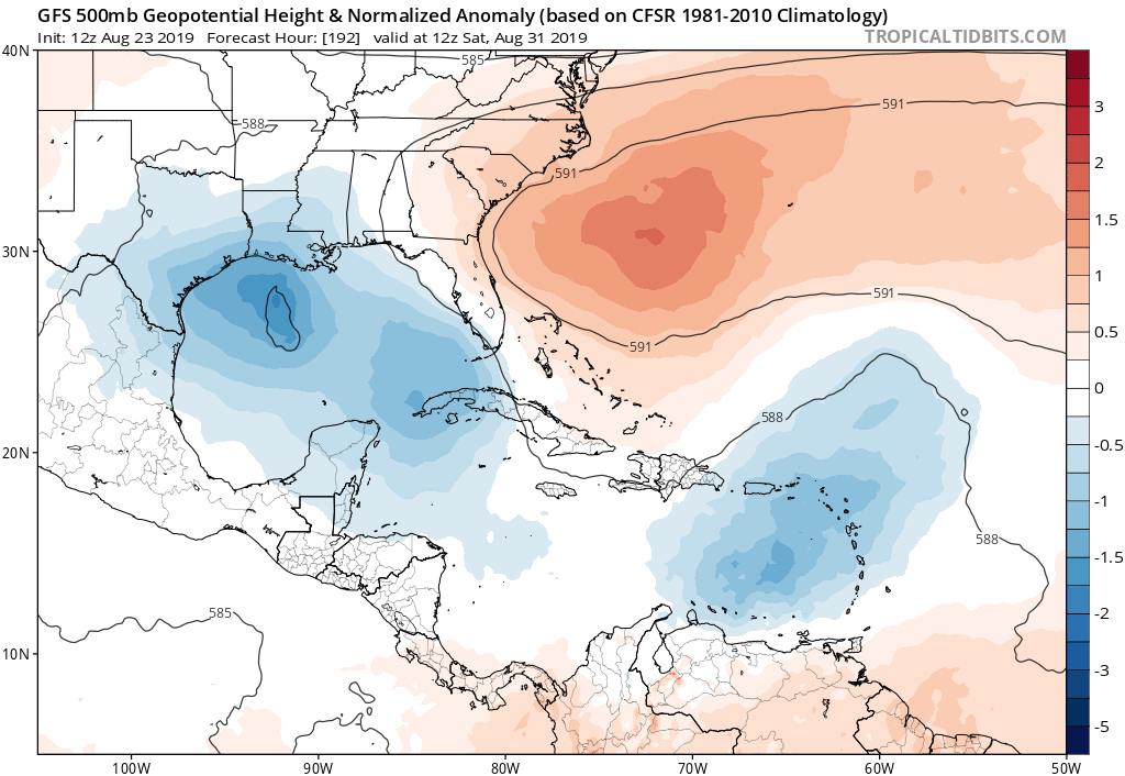
Both the Euro and GFS show a building and expanding Bermuda High ridge after a week so 99l may not have recurve out to sea route if it heads north of the islands:
0 likes
-
AutoPenalti
- Category 5

- Posts: 4091
- Age: 29
- Joined: Mon Aug 17, 2015 4:16 pm
- Location: Ft. Lauderdale, Florida
Re: ATL: INVEST 99L - Models
NotSparta wrote:AutoPenalti wrote:Siding with the Euro on this one, MDR is still too hostile and shear is waiting for it in the Caribbean.
That's a bold strategy, given that run practically caved to the GFS wrt development
That dry air mass is still in place. It hasn’t gone anywhere.
1 likes
The posts in this forum are NOT official forecasts and should not be used as such. They are just the opinion of the poster and may or may not be backed by sound meteorological data. They are NOT endorsed by any professional institution or STORM2K. For official information, please refer to products from the NHC and NWS.
Model Runs Cheat Sheet:
GFS (5:30 AM/PM, 11:30 AM/PM)
HWRF, GFDL, UKMET, NAVGEM (6:30-8:00 AM/PM, 12:30-2:00 AM/PM)
ECMWF (1:45 AM/PM)
TCVN is a weighted averaged
-
CrazyC83
- Professional-Met

- Posts: 34315
- Joined: Tue Mar 07, 2006 11:57 pm
- Location: Deep South, for the first time!
Re: ATL: INVEST 99L - Models
If this is going to be significant, it probably needs to go north of the islands. The eastern Caribbean looks like a graveyard, but the subtropical Atlantic looks ready to go.
8 likes
-
cycloneye

- Admin

- Posts: 149275
- Age: 69
- Joined: Thu Oct 10, 2002 10:54 am
- Location: San Juan, Puerto Rico
Re: ATL: INVEST 99L - Models
Anyone have the ensembles from GFS and Euro?
0 likes
Visit the Caribbean-Central America Weather Thread where you can find at first post web cams,radars
and observations from Caribbean basin members Click Here
and observations from Caribbean basin members Click Here
-
TheStormExpert
Re: ATL: INVEST 99L - Models
cycloneye wrote:Anyone have the ensembles from GFS and Euro?
Here are the 12z GFS and Euro Ensembles.


Last edited by TheStormExpert on Fri Aug 23, 2019 3:13 pm, edited 1 time in total.
1 likes


Re: ATL: INVEST 99L - Models

Last edited by Highteeld on Fri Aug 23, 2019 3:13 pm, edited 1 time in total.
1 likes
Very useful information on the Dvorak Technique --
https://severe.worldweather.wmo.int/TCF ... kBeven.pdf
https://severe.worldweather.wmo.int/TCF ... kBeven.pdf
-
Kingarabian
- S2K Supporter
- Posts: 16348
- Joined: Sat Aug 08, 2009 3:06 am
- Location: Honolulu, Hawaii
Re: ATL: INVEST 99L - Models
cycloneye wrote:Anyone have the ensembles from GFS and Euro?
Through 10 days: 12z EPS has about 4 members (1004mb or lower) developing this with tracks similar to the operation Euro.
Last edited by Kingarabian on Fri Aug 23, 2019 3:19 pm, edited 1 time in total.
1 likes
RIP Kobe Bryant
-
Hurricaneman

- Category 5
- Posts: 7404
- Age: 45
- Joined: Tue Aug 31, 2004 3:24 pm
- Location: central florida
Re: ATL: INVEST 99L - Models
In 7 days the 18zGFS is showing a strong tropical storm near Puerto Rico, similar track to the Euro, may be bad news for Hispaniola with this track, if this goes 50 to 100 miles north of that Florida could have some trouble, it all depends on when the weakness fills in
0 likes
Re: ATL: INVEST 99L - Models
SFLcane wrote:cycloneye wrote:Anyone have the ensembles from GFS and Euro?
https://i.imgur.com/F4mFW1f.png
Fwiw, that 979 mb EPS member at day 10 hits Ft. Pierce, FL, 2 days later (9/4) as a formidable H. One other member hits as a 992ish storm the same day. Otherwise, there are no major hits through the 15 day run.
Last edited by LarryWx on Fri Aug 23, 2019 5:51 pm, edited 1 time in total.
0 likes
Personal Forecast Disclaimer:
The posts in this forum are NOT official forecasts and should not be used as such. They are just the opinion of the poster and may or may not be backed by sound meteorological data. They are NOT endorsed by any professional institution or storm2k.org. For official information, please refer to the NHC and NWS products.
The posts in this forum are NOT official forecasts and should not be used as such. They are just the opinion of the poster and may or may not be backed by sound meteorological data. They are NOT endorsed by any professional institution or storm2k.org. For official information, please refer to the NHC and NWS products.
-
TheStormExpert
Re: ATL: INVEST 99L - Models
18z GFS with a TS into the Lesser Antilles and a hurricane slams and gets shredded by Hispaniola. Need to watch future runs to see if it’s just the “Happy Hour” GFS doing its thing or a real deal since shear doesn’t seem to be an issue this run.

Last edited by TheStormExpert on Fri Aug 23, 2019 5:48 pm, edited 1 time in total.
2 likes
-
Hypercane_Kyle

- Category 5
- Posts: 3465
- Joined: Sat Mar 07, 2015 7:58 pm
- Location: Cape Canaveral, FL
Re: ATL: INVEST 99L - Models
Hurricaneman wrote:In 7 days the 18zGFS is showing a strong tropical storm near Puerto Rico, similar track to the Euro, may be bad news for Hispaniola with this track, if this goes 50 to 100 miles north of that Florida could have some trouble, it all depends on when the weakness fills in
Full-res shows a Cat 1 hurricane.
0 likes
My posts are my own personal opinion, defer to the National Hurricane Center (NHC) and other NOAA products for decision making during hurricane season.
Re: ATL: INVEST 99L - Models
18Z GEFS: 4 of ~21 members hit the CONUS as a TS+: 2 on 9/5 (S FL/LA/TX border), SE LA 9/6, LA/TX border 9/8
2 likes
Personal Forecast Disclaimer:
The posts in this forum are NOT official forecasts and should not be used as such. They are just the opinion of the poster and may or may not be backed by sound meteorological data. They are NOT endorsed by any professional institution or storm2k.org. For official information, please refer to the NHC and NWS products.
The posts in this forum are NOT official forecasts and should not be used as such. They are just the opinion of the poster and may or may not be backed by sound meteorological data. They are NOT endorsed by any professional institution or storm2k.org. For official information, please refer to the NHC and NWS products.

Re: ATL: INVEST 99L - Models
Decent chance this makes it into the Gulf if it can survive. Should be fun to track.
0 likes
Re: ATL: INVEST 99L - Models
LarryWx wrote:18Z GEFS: 4 of ~21 members hit the CONUS as a TS+: 2 on 9/5 (S FL/LA/TX border), SE LA 9/6, LA/TX border 9/8
Yet the op slams it into Mexico as a cat 1 or 2.
0 likes
-
Hurricaneman
- Category 5
- Posts: 7404
- Age: 45
- Joined: Tue Aug 31, 2004 3:24 pm
- Location: central florida
Re: ATL: INVEST 99L - Models
At the end of the 18zGFS run has a final landfalling hurricane near Veracruz from this, This is probably going to change many times before we know the final outcome
1 likes


-
Hypercane_Kyle
- Category 5
- Posts: 3465
- Joined: Sat Mar 07, 2015 7:58 pm
- Location: Cape Canaveral, FL
Re: ATL: INVEST 99L - Models
What's funny is that the ECMWF is a higher resolution model than the GFS, yet somehow cannot pick this system up.
1 likes
My posts are my own personal opinion, defer to the National Hurricane Center (NHC) and other NOAA products for decision making during hurricane season.
Who is online
Users browsing this forum: No registered users and 19 guests