ATL: DORIAN - Post-Tropical - Discussion
Moderator: S2k Moderators
-
Aric Dunn
- Category 5

- Posts: 21238
- Age: 43
- Joined: Sun Sep 19, 2004 9:58 pm
- Location: Ready for the Chase.
- Contact:
Re: ATL: DORIAN - Tropical Storm - Discussion
Well at least tomorrow we will have radar.
1 likes
Note: If I make a post that is brief. Please refer back to previous posts for the analysis or reasoning. I do not re-write/qoute what my initial post said each time.
If there is nothing before... then just ask
Space & Atmospheric Physicist, Embry-Riddle Aeronautical University,
I believe the sky is falling...
If there is nothing before... then just ask
Space & Atmospheric Physicist, Embry-Riddle Aeronautical University,
I believe the sky is falling...
-
gatorcane

- S2K Supporter

- Posts: 23708
- Age: 48
- Joined: Sun Mar 13, 2005 3:54 pm
- Location: Boca Raton, FL
Re: ATL: DORIAN - Tropical Storm - Discussion
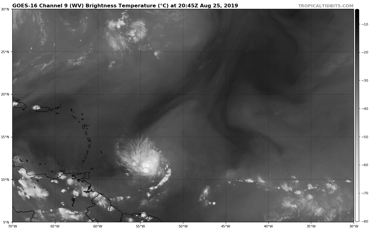
You can see Dorian continues to fight the dry wedge of air to the west (dark color):
3 likes
-
Aric Dunn
- Category 5
- Posts: 21238
- Age: 43
- Joined: Sun Sep 19, 2004 9:58 pm
- Location: Ready for the Chase.
- Contact:
Re: ATL: DORIAN - Tropical Storm - Discussion
Looks like 3rd convective boost is starting. lets see if this will be enough
0 likes
Note: If I make a post that is brief. Please refer back to previous posts for the analysis or reasoning. I do not re-write/qoute what my initial post said each time.
If there is nothing before... then just ask
Space & Atmospheric Physicist, Embry-Riddle Aeronautical University,
I believe the sky is falling...
If there is nothing before... then just ask
Space & Atmospheric Physicist, Embry-Riddle Aeronautical University,
I believe the sky is falling...
-
Kingarabian

- S2K Supporter
- Posts: 16366
- Joined: Sat Aug 08, 2009 3:06 am
- Location: Honolulu, Hawaii
Re: ATL: DORIAN - Tropical Storm - Discussion
gatorcane wrote:You can see Dorian continues to fight the dry wedge of air to the west (dark color):
[url]https://i.postimg.cc/4nCVgwHJ/goes16-wv-mid-catl-201908252045.jpg[url]
Hot towers continue to go off near the COC but remain fragmented and unable to expand and so it's been hard for it to maintain a deep CDO.
0 likes
RIP Kobe Bryant
-
GeneratorPower

- S2K Supporter
- Posts: 1648
- Age: 46
- Joined: Sun Dec 18, 2005 11:48 pm
- Location: Huntsville, AL
Re: ATL: DORIAN - Tropical Storm - Discussion
The interesting thing about this storm is it already has a well defined core. Has for a while now. So many storms we track struggle to gain a well defined LLC.
4 likes

Re: ATL: DORIAN - Tropical Storm - Discussion
TheStormExpert wrote:https://twitter.com/DerekOrtt/status/1165794971481456641
So how strong would that indicate? I'm not the greatest with reading wind barbs.
0 likes
-
1900hurricane

- Category 5
- Posts: 6063
- Age: 34
- Joined: Fri Feb 06, 2015 12:04 pm
- Location: Houston, TX
- Contact:
Re: ATL: DORIAN - Tropical Storm - Discussion
cycloneye wrote:TXNT28 KNES 260021
TCSNTL
A. 05L (DORIAN)
B. 26/0000Z
C. 11.5N
D. 54.4W
E. THREE/GOES-E
F. T3.5/3.5/D1.5/24HRS
G. IR/EIR/SWIR/WINDSAT
H. REMARKS...SYSTEM IS CHARACTERIZED BY A CENTRAL COLD COVER ATTM
BUT 7/10 BANDING WAS INFERRED IN A SSMIS PASS FROM 2219Z, WHICH WOULD
RESULT IN A DT OF 3.0. MET IS 3.0 BUT PT IS 3.5 BASED ON EYE-LIKE FEATURE
APPEARING IN THE 2146Z WINDSAT IMAGE. FT IS BASED ON PT BECAUSE BANDING
FEATURES COULD NOT BE DISCERNED IN THE CURRENT EIR IMAGERY.
I. ADDL POSITIONS
25/2146Z 11.5N 54.0W WINDSAT
...TURK
That's an odd fix. Never seen a pattern number assessed on a microwave image rather than the given IR image. Technically that shouldn't even be allowable under strict adherence to the Dvorak Technique.
2 likes
Contract Meteorologist. TAMU & MSST. Fiercely authentic, one of a kind. We are all given free will, so choose a life meant to be lived. We are the Masters of our own Stories.
Opinions expressed are mine alone.
Follow me on Twitter at @1900hurricane : Read blogs at https://1900hurricane.wordpress.com/
Opinions expressed are mine alone.
Follow me on Twitter at @1900hurricane : Read blogs at https://1900hurricane.wordpress.com/
-
CrazyC83
- Professional-Met

- Posts: 34315
- Joined: Tue Mar 07, 2006 11:57 pm
- Location: Deep South, for the first time!
Re: ATL: DORIAN - Tropical Storm - Discussion
Homie J wrote:TheStormExpert wrote:https://twitter.com/DerekOrtt/status/1165794971481456641
So how strong would that indicate? I'm not the greatest with reading wind barbs.
Strongest wind barb is 35 kt, but the resolution is very low. The current NHC estimate is probably reasonable.
0 likes
-
Blown Away

- S2K Supporter
- Posts: 10253
- Joined: Wed May 26, 2004 6:17 am
Re: ATL: DORIAN - Tropical Storm - Discussion

I attempted to draw the 00z TVCN Consensus line (NHC seems to follow this consensus line closely) compared to the 5pm NHC line... They flattened the line from 11am to 5pm, but didn't move it much north over Hispaniola, so I think at 11pm we will see a track inched N with less Hispaniola interaction and will that change intensity forecast???
0 likes
Hurricane Eye Experience: David 79, Irene 99, Frances 04, Jeanne 04, Wilma 05… Hurricane Brush Experience: Andrew 92, Erin 95, Floyd 99, Matthew 16, Irma 17, Ian 22, Nicole 22…
-
Hypercane_Kyle

- Category 5
- Posts: 3465
- Joined: Sat Mar 07, 2015 7:58 pm
- Location: Cape Canaveral, FL
Re: ATL: DORIAN - Tropical Storm - Discussion
GeneratorPower wrote:The interesting thing about this storm is it already has a well defined core. Has for a while now. So many storms we track struggle to gain a well defined LLC.
Usually because they're trucking at like 30 knots due west due to incredibly fast trade winds and can't close off properly.
1 likes
My posts are my own personal opinion, defer to the National Hurricane Center (NHC) and other NOAA products for decision making during hurricane season.
-
Aric Dunn
- Category 5
- Posts: 21238
- Age: 43
- Joined: Sun Sep 19, 2004 9:58 pm
- Location: Ready for the Chase.
- Contact:
Re: ATL: DORIAN - Tropical Storm - Discussion
an actual curved band has developed NW to SE around the center. looks like the vorticity has transferred up through the column more.
1 likes
Note: If I make a post that is brief. Please refer back to previous posts for the analysis or reasoning. I do not re-write/qoute what my initial post said each time.
If there is nothing before... then just ask
Space & Atmospheric Physicist, Embry-Riddle Aeronautical University,
I believe the sky is falling...
If there is nothing before... then just ask
Space & Atmospheric Physicist, Embry-Riddle Aeronautical University,
I believe the sky is falling...
-
Ian2401
- Category 1

- Posts: 321
- Joined: Thu Sep 14, 2017 5:55 pm
- Location: Tallahassee, Florida
- Contact:
Re: ATL: DORIAN - Tropical Storm - Discussion
Hypercane_Kyle wrote:GeneratorPower wrote:The interesting thing about this storm is it already has a well defined core. Has for a while now. So many storms we track struggle to gain a well defined LLC.
Usually because they're trucking at like 30 knots due west due to incredibly fast trade winds and can't close off properly.
i think its small size is helping that a lot. small storms can ramp up and die down very quickly. has been a champ so far with the dry air tho so far lol all things considered.
0 likes
B.S. Meteorology from Florida State '24 // Current M.S. Meteorology student at Florida State
Research Interests: Rapid Intensification, TC Climatology, TC Modeling
Consult the NHC for official information
Research Interests: Rapid Intensification, TC Climatology, TC Modeling
Consult the NHC for official information
-
1900hurricane
- Category 5
- Posts: 6063
- Age: 34
- Joined: Fri Feb 06, 2015 12:04 pm
- Location: Houston, TX
- Contact:
Re: ATL: DORIAN - Tropical Storm - Discussion
The average tropical storm force wind radius more than doubled between 18Z and 00Z, partially due to the system being assessed stronger and having TS wind radii in all four quadrants now. Regardless, TIKE more than doubled at 00Z, despite now being around 1.5 TS Days. Of course when I say doubled, 00Z IKE is still only barely over 2 TJ, so Dorian is still a very small system, although you probably didn't need me to tell you that.
5 likes
Contract Meteorologist. TAMU & MSST. Fiercely authentic, one of a kind. We are all given free will, so choose a life meant to be lived. We are the Masters of our own Stories.
Opinions expressed are mine alone.
Follow me on Twitter at @1900hurricane : Read blogs at https://1900hurricane.wordpress.com/
Opinions expressed are mine alone.
Follow me on Twitter at @1900hurricane : Read blogs at https://1900hurricane.wordpress.com/

Re: ATL: DORIAN - Tropical Storm - Discussion
CrazyC83 wrote:Homie J wrote:TheStormExpert wrote:https://twitter.com/DerekOrtt/status/1165794971481456641
So how strong would that indicate? I'm not the greatest with reading wind barbs.
Strongest wind barb is 35 kt, but the resolution is very low. The current NHC estimate is probably reasonable.
Less than ASCAT right? Or are they about the same?
0 likes
The above post is not official and should not be used as such. It is the opinion of the poster and may or may not be backed by sound meteorological data. It is not endorsed by any professional institution or storm2k.org. For official information, please refer to the NHC and NWS products.
-
Blown Away
- S2K Supporter
- Posts: 10253
- Joined: Wed May 26, 2004 6:17 am
Re: ATL: DORIAN - Tropical Storm - Discussion

Historical Aug/Sept tracks within 75 miles of the NHC 5 day point for Dorian... GOM is a real possibility after raking the entire Caribbean...
0 likes
Hurricane Eye Experience: David 79, Irene 99, Frances 04, Jeanne 04, Wilma 05… Hurricane Brush Experience: Andrew 92, Erin 95, Floyd 99, Matthew 16, Irma 17, Ian 22, Nicole 22…
-
AtlanticWind

- S2K Supporter
- Posts: 1898
- Age: 67
- Joined: Sun Aug 08, 2004 9:57 pm
- Location: Plantation,Fla
Re: ATL: DORIAN - Tropical Storm - Discussion
Wonder if the NHC. Is considering a hurricane watch for some of the islands in case of a ramp up.
1 likes
-
TheAustinMan

- Category 5
- Posts: 1060
- Joined: Mon Jul 08, 2013 4:26 pm
- Location: Central TX / United States
Re: ATL: DORIAN - Tropical Storm - Discussion
AMSU pressure estimate continues to fall and is now estimating a central pressure of 991 mbar based on the properties of Dorian's warm core. Such pressures for a storm of Dorian's size are typically indicative of a strong tropical storm or low-end hurricane. Would be very interested in a high-resolution GMI/AMSR2 microwave pass of Dorian given it already looks quite a bit different than it did just two hours ago with a new burst of convection.
5 likes
Treat my opinions with a grain of salt. For official information see your local weather service.
“It's tough to make predictions, especially about the future.”
“It's tough to make predictions, especially about the future.”
-
toad strangler

- S2K Supporter
- Posts: 4546
- Joined: Sun Jul 28, 2013 3:09 pm
- Location: Earth
- Contact:
Re: ATL: DORIAN - Tropical Storm - Discussion
Blown Away wrote:https://i.imgur.com/1RDuyZR.jpg
Historical Aug/Sept tracks within 75 miles of the NHC 5 day point for Dorian... GOM is a real possibility after raking the entire Caribbean...
ha Jeanne is on there
1 likes
My Weather Station
https://www.wunderground.com/dashboard/pws/KFLPORTS603
https://www.wunderground.com/dashboard/pws/KFLPORTS603
-
Evil Jeremy

- S2K Supporter
- Posts: 5463
- Age: 32
- Joined: Mon Apr 10, 2006 2:10 pm
- Location: Los Angeles, CA
Re: ATL: DORIAN - Tropical Storm - Discussion
If the South/East Florida scenario were to play out, impact looks to be next Sunday, a week from today. If I get off work tomorrow and models are holding steady, I'm getting my basic supplies. Not getting caught off guard. Hopefully not, but if there were to be madness in anticipation of a Hurricane here, it would be kicking in around Wednesday.
6 likes
Frances 04 / Jeanne 04 / Katrina 05 / Wilma 05 / Fay 08 / Debby 12 / Andrea 13 / Colin 16 / Hermine 16 / Matthew 16 / Irma 17
Who is online
Users browsing this forum: No registered users and 69 guests