ATL: DORIAN - Post-Tropical - Discussion

Moderator: S2k Moderators

Message
Author
Aric Dunn
Category 5
Category 5
Posts: 21238
Age: 42
Joined: Sun Sep 19, 2004 9:58 pm
Location: Ready for the Chase.
Contact:

Re: ATL: DORIAN - Tropical Storm - Discussion

#581 Postby Aric Dunn » Mon Aug 26, 2019 7:51 am

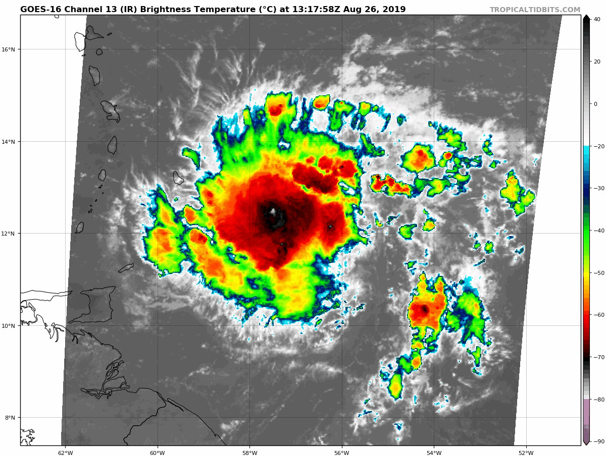
jconsor wrote:Microwave images appear to show a partial eyewall.

https://imgur.com/qE7LAqr

AL, 05, 201908261020, 30, WSAT, C, , 1200N, 5680W, , 2, , , , 3, , , , , , , , , , , , 3, , , , NHC, SRS, , , , , , , , , WSAT, , , , , , , , , , , , , , , , , , , 3, pbo partial 75pct eyewall in 37GHz data

(From https://ftp.nhc.noaa.gov/atcf/fix/fal052019.dat)


Yeah looks like 50 percent the entire northern semi circle.
0 likes   
Note: If I make a post that is brief. Please refer back to previous posts for the analysis or reasoning. I do not re-write/qoute what my initial post said each time.
If there is nothing before... then just ask :)

Space & Atmospheric Physicist, Embry-Riddle Aeronautical University,
I believe the sky is falling...

User avatar
northjaxpro
S2K Supporter
S2K Supporter
Posts: 8900
Joined: Mon Sep 27, 2010 11:21 am
Location: Jacksonville, FL

Re: ATL: DORIAN - Tropical Storm - Discussion

#582 Postby northjaxpro » Mon Aug 26, 2019 7:51 am

AutoPenalti wrote:The larger this becomes, the more it can filter out the dry air by creating a moisture pocket. NHC forecasted Dorian to become a hurricane by Thursday afternoon.


This will happen way sooner than that based on what I am seeing right now.
0 likes   
NEVER, EVER SAY NEVER in the tropics and weather in general, and most importantly, with life itself!!

________________________________________________________________________________________

Fay 2008 Beryl 2012 Debby 2012 Colin 2016 Hermine 2016 Julia 2016 Matthew 2016 Irma 2017 Dorian 2019

User avatar
SFLcane
S2K Supporter
S2K Supporter
Posts: 10163
Age: 47
Joined: Sat Jun 05, 2010 1:44 pm
Location: Lake Worth Florida

Re: ATL: DORIAN - Tropical Storm - Discussion

#583 Postby SFLcane » Mon Aug 26, 2019 7:52 am

0 likes   

User avatar
Highteeld
Category 5
Category 5
Posts: 2139
Age: 41
Joined: Tue Jan 30, 2018 9:10 pm
Location: Chicago

Re: ATL: DORIAN - Tropical Storm - Discussion

#584 Postby Highteeld » Mon Aug 26, 2019 8:00 am

Northern extend of the tropical storm force wind field has greatly expanded:

NHC will likely go 55 or 60 knots for 11 AM. Given Stewart is on shift, might go for 60, as he is probably the most aggressive senior hurricane specialist there.

Image
2 likes   
Very useful information on the Dvorak Technique --

https://severe.worldweather.wmo.int/TCF ... kBeven.pdf

User avatar
Highteeld
Category 5
Category 5
Posts: 2139
Age: 41
Joined: Tue Jan 30, 2018 9:10 pm
Location: Chicago

Re: ATL: DORIAN - Tropical Storm - Discussion

#585 Postby Highteeld » Mon Aug 26, 2019 8:03 am

Weatherboy1 wrote:To me, the biggest development overnight is the notable shift in modeling to the NE down the road. More models seem to suggest Dorian could cross over the eastern end of the island of Hispanola - or miss it entirely. As you can see from the topographical map here, that isn't where the biggest, most-disruptive mountains are located. In other words, a difference of maybe 50-100 miles can make a huge difference in the system's ultimate strength. Certainly paying closer attention here in SE FL given the trends seen over the last 24 hours

https://upload.wikimedia.org/wikipedia/commons/b/bb/Hispaniola_lrg.jpg


This is a great point. If Dorian threads the needle between PR and Hispaniola, could lead for a dangerous situation for the Bahamas. For those of you who have been watching the BT/Microwave fix data, you all have seen it move slightly north of west for a while. The upper air mission yesterday is probably a big reason in the shift north -- regarding modeling -- we have seen.
0 likes   
Very useful information on the Dvorak Technique --

https://severe.worldweather.wmo.int/TCF ... kBeven.pdf

User avatar
Siker
Category 4
Category 4
Posts: 904
Age: 28
Joined: Thu Oct 25, 2012 7:36 pm
Location: Miami, FL

Re: ATL: DORIAN - Tropical Storm - Discussion

#586 Postby Siker » Mon Aug 26, 2019 8:07 am

Upper level outflow present on the southern side unlike yesterday.
1 likes   

User avatar
GCANE
S2K Supporter
S2K Supporter
Posts: 11497
Joined: Mon Oct 22, 2007 8:03 am

Re: ATL: DORIAN - Tropical Storm - Discussion

#587 Postby GCANE » Mon Aug 26, 2019 8:08 am

Leading convection is taking out a good chunk of the dry slot to the west.

1 likes   

User avatar
SFLcane
S2K Supporter
S2K Supporter
Posts: 10163
Age: 47
Joined: Sat Jun 05, 2010 1:44 pm
Location: Lake Worth Florida

Re: ATL: DORIAN - Tropical Storm - Discussion

#588 Postby SFLcane » Mon Aug 26, 2019 8:08 am

Highteeld wrote:
Weatherboy1 wrote:To me, the biggest development overnight is the notable shift in modeling to the NE down the road. More models seem to suggest Dorian could cross over the eastern end of the island of Hispanola - or miss it entirely. As you can see from the topographical map here, that isn't where the biggest, most-disruptive mountains are located. In other words, a difference of maybe 50-100 miles can make a huge difference in the system's ultimate strength. Certainly paying closer attention here in SE FL given the trends seen over the last 24 hours

https://upload.wikimedia.org/wikipedia/commons/b/bb/Hispaniola_lrg.jpg


This is a great point. If Dorian threads the needle between PR and Hispaniola, could lead for a dangerous situation for the Bahamas. For those of you who have been watching the BT/Microwave fix data, you all have seen it move slightly north of west for a while. The upper air mission yesterday is probably a big reason in the shift north -- regarding modeling -- we have seen.


Yep I don't think it's a coincidence the Euro keeps it after all those sondes got in.
0 likes   

User avatar
NDG
S2K Supporter
S2K Supporter
Posts: 15446
Joined: Sun Jul 09, 2006 10:14 pm
Location: Orlando, FL

Re: ATL: DORIAN - Tropical Storm - Discussion

#589 Postby NDG » Mon Aug 26, 2019 8:10 am

Definitely its circulation coverage has grown, throw out the GFS and Euro runs out from 24 hours ago when they were showing to stay small and weak as it was to approach the Windward Islands.

Image
4 likes   

User avatar
NDG
S2K Supporter
S2K Supporter
Posts: 15446
Joined: Sun Jul 09, 2006 10:14 pm
Location: Orlando, FL

Re: ATL: DORIAN - Tropical Storm - Discussion

#590 Postby NDG » Mon Aug 26, 2019 8:26 am

Too bad Barbados radar is down, has been down for a while now.
0 likes   

User avatar
Kazmit
Category 5
Category 5
Posts: 2124
Age: 22
Joined: Mon Jul 25, 2016 8:49 am
Location: Williamsburg, VA / Bermuda

Re: ATL: DORIAN - Tropical Storm - Discussion

#591 Postby Kazmit » Mon Aug 26, 2019 8:26 am

Hurricane watch for the islands at 11am?
0 likes   
Igor 2010, Sandy 2012, Fay 2014, Gonzalo 2014, Joaquin 2015, Nicole 2016, Humberto 2019

I am only a tropical weather enthusiast. My predictions are not official and may or may not be backed by sound meteorological data. For official information, please refer to the NHC and NWS products.

zhukm29
Category 1
Category 1
Posts: 279
Joined: Tue Aug 28, 2018 2:37 pm

Re: ATL: DORIAN - Tropical Storm - Discussion

#592 Postby zhukm29 » Mon Aug 26, 2019 8:29 am

The storm is much larger now than it was yesterday.

Image
1 likes   

User avatar
Blown Away
S2K Supporter
S2K Supporter
Posts: 10146
Joined: Wed May 26, 2004 6:17 am

Re: ATL: DORIAN - Tropical Storm - Discussion

#593 Postby Blown Away » Mon Aug 26, 2019 8:29 am

Image
0 likes   
Hurricane Eye Experience: David 79, Irene 99, Frances 04, Jeanne 04, Wilma 05... EYE COMING MY WAY IN 2024…
Hurricane Brush Experience: Andrew 92, Erin 95, Floyd 99, Matthew 16, Irma 17, Ian 22, Nicole 22…

Dean4Storms
S2K Supporter
S2K Supporter
Posts: 6358
Age: 62
Joined: Sun Aug 31, 2003 1:01 pm
Location: Miramar Bch. FL

Re: ATL: DORIAN - Tropical Storm - Discussion

#594 Postby Dean4Storms » Mon Aug 26, 2019 8:30 am

Agree generally with everyone about the size of Dorian this morning. His moisture envelope and convective area has expanded and no doubt his wind field and strength both growing. I have to admit that I thought this system was doomed once it reached the Carib. Islands a couple days back, not so anymore. Looks like the first potential Tropical Wave to TC threat for the US.
0 likes   

USTropics
Professional-Met
Professional-Met
Posts: 2651
Joined: Sun Aug 12, 2007 3:45 am
Location: Florida State University

Re: ATL: DORIAN - Tropical Storm - Discussion

#595 Postby USTropics » Mon Aug 26, 2019 8:31 am

We can start to track the UL features with 200mb vort charts, how quickly and to what degree that upper-level trough moves SW that's currently diving towards the Caribbean is one key feature to watch:
Image
3 likes   

User avatar
Hurricane Jed
Category 2
Category 2
Posts: 545
Age: 37
Joined: Mon Jan 24, 2011 3:36 pm
Location: Cen Tex

Re: ATL: DORIAN - Tropical Storm - Discussion

#596 Postby Hurricane Jed » Mon Aug 26, 2019 8:35 am

Dean4Storms wrote:Agree generally with everyone about the size of Dorian this morning. His moisture envelope and convective area has expanded and no doubt his wind field and strength both growing. I have to admit that I thought this system was doomed once it reached the Carib. Islands a couple days back, not so anymore. Looks like the first potential Tropical Wave to TC threat for the US.


You know we had Barry right?
0 likes   

User avatar
Kazmit
Category 5
Category 5
Posts: 2124
Age: 22
Joined: Mon Jul 25, 2016 8:49 am
Location: Williamsburg, VA / Bermuda

Re: ATL: DORIAN - Tropical Storm - Discussion

#597 Postby Kazmit » Mon Aug 26, 2019 8:37 am

Hurricane Jed wrote:
Dean4Storms wrote:Agree generally with everyone about the size of Dorian this morning. His moisture envelope and convective area has expanded and no doubt his wind field and strength both growing. I have to admit that I thought this system was doomed once it reached the Carib. Islands a couple days back, not so anymore. Looks like the first potential Tropical Wave to TC threat for the US.


You know we had Barry right?

Barry didn't form from a tropical wave.
3 likes   
Igor 2010, Sandy 2012, Fay 2014, Gonzalo 2014, Joaquin 2015, Nicole 2016, Humberto 2019

I am only a tropical weather enthusiast. My predictions are not official and may or may not be backed by sound meteorological data. For official information, please refer to the NHC and NWS products.

User avatar
Bostonriff
Tropical Low
Tropical Low
Posts: 33
Joined: Tue Sep 05, 2017 9:23 pm

Re: ATL: DORIAN - Tropical Storm - Discussion

#598 Postby Bostonriff » Mon Aug 26, 2019 8:39 am

This is the fun part, equivalent to chasing in the plains, and watching a gnarly bear's cage and wondering how big of a hose will drop.
0 likes   
Do not bet the ranch based on any non-official forecasts that may appear in the post above no matter how strongly argued they may be, because the fates are capricious and have Murphy's Law on speed-dial.

zhukm29
Category 1
Category 1
Posts: 279
Joined: Tue Aug 28, 2018 2:37 pm

Re: ATL: DORIAN - Tropical Storm - Discussion

#599 Postby zhukm29 » Mon Aug 26, 2019 8:39 am

4 likes   

User avatar
Hurricane Jed
Category 2
Category 2
Posts: 545
Age: 37
Joined: Mon Jan 24, 2011 3:36 pm
Location: Cen Tex

Re: ATL: DORIAN - Tropical Storm - Discussion

#600 Postby Hurricane Jed » Mon Aug 26, 2019 8:40 am

Kazmit wrote:
Hurricane Jed wrote:
Dean4Storms wrote:Agree generally with everyone about the size of Dorian this morning. His moisture envelope and convective area has expanded and no doubt his wind field and strength both growing. I have to admit that I thought this system was doomed once it reached the Carib. Islands a couple days back, not so anymore. Looks like the first potential Tropical Wave to TC threat for the US.


You know we had Barry right?

Barry didn't form from a tropical wave.


I read it as if he was talking about a range. Getting anywhere from a wave to a TC.
0 likes   


Return to “2019”

Who is online

Users browsing this forum: No registered users and 3 guests