ATL: DORIAN - Post-Tropical - Discussion
Moderator: S2k Moderators
-
eastcoastFL

- Category 5

- Posts: 3996
- Age: 44
- Joined: Thu Apr 12, 2007 12:29 pm
- Location: Palm City, FL
Re: ATL: DORIAN - Tropical Storm - Discussion
Local Mets showing landfall right where I live. Normally I’d feel good this far out being in the bullseye. But that ridge doesn’t leave a ton of room for it to go. The only thing that seems up in the air is intensity .
0 likes
Personal Forecast Disclaimer:
The posts in this forum are NOT official forecast and should not be used as such. They are just the opinion of the poster and may or may not be backed by sound meteorological data. They are NOT endorsed by any professional institution or storm2k.org. For official information, please refer to the NHC and NWS products.
The posts in this forum are NOT official forecast and should not be used as such. They are just the opinion of the poster and may or may not be backed by sound meteorological data. They are NOT endorsed by any professional institution or storm2k.org. For official information, please refer to the NHC and NWS products.
-
Aric Dunn
- Category 5
- Posts: 21238
- Age: 43
- Joined: Sun Sep 19, 2004 9:58 pm
- Location: Ready for the Chase.
- Contact:
Re: ATL: DORIAN - Tropical Storm - Discussion
GCANE wrote:Since last microwave analysis showed center was north of operational track, it looks like convection is firing right on top of the CoC per the RAMMB IR depiction.
https://i.imgur.com/xUJE5tV.jpg
If it is there than the mid level and low level are not stacked
1 likes
Note: If I make a post that is brief. Please refer back to previous posts for the analysis or reasoning. I do not re-write/qoute what my initial post said each time.
If there is nothing before... then just ask
Space & Atmospheric Physicist, Embry-Riddle Aeronautical University,
I believe the sky is falling...
If there is nothing before... then just ask
Space & Atmospheric Physicist, Embry-Riddle Aeronautical University,
I believe the sky is falling...
-
jlauderdal
- S2K Supporter

- Posts: 7240
- Joined: Wed May 19, 2004 5:46 am
- Location: NE Fort Lauderdale
- Contact:
Re: ATL: DORIAN - Tropical Storm - Discussion
Watch john, if he says florida should be concerned, go get supplies...that would be 180 from his view yesterday
https://m.facebook.com/johnmoralesnbc6
Sent from my SM-G973U using Tapatalk
https://m.facebook.com/johnmoralesnbc6
Sent from my SM-G973U using Tapatalk
1 likes

Re: ATL: DORIAN - Tropical Storm - Discussion
Looking at visible, there was some sort of massive outflow burst started around 1245Z on the west side.
0 likes
-
jlauderdal
- S2K Supporter
- Posts: 7240
- Joined: Wed May 19, 2004 5:46 am
- Location: NE Fort Lauderdale
- Contact:
Re: RE: Re: ATL: DORIAN - Tropical Storm - Discussion
The days of felling good about being on a 5 day nhc track are almost over, they are too good noweastcoastFL wrote:Local Mets showing landfall right where I live. Normally I’d feel good this far out being in the bullseye. But that ridge doesn’t leave a ton of room for it to go. The only thing that seems up in the air is intensity .
Sent from my SM-G973U using Tapatalk
5 likes
-
AxaltaRacing24
- Category 5
- Posts: 1774
- Age: 25
- Joined: Wed Jul 27, 2016 11:14 am
- Location: Jupiter, FL
Re: ATL: DORIAN - Tropical Storm - Discussion
eastcoastFL wrote:Local Mets showing landfall right where I live. Normally I’d feel good this far out being in the bullseye. But that ridge doesn’t leave a ton of room for it to go. The only thing that seems up in the air is intensity .
this is what i have noticed. with this ridge in place, somebody in the u.s. will be getting impacts.
1 likes
-
northjaxpro

- S2K Supporter
- Posts: 8900
- Joined: Mon Sep 27, 2010 11:21 am
- Location: Jacksonville, FL
Re: ATL: DORIAN - Tropical Storm - Discussion
AxaltaRacing24 wrote:eastcoastFL wrote:Local Mets showing landfall right where I live. Normally I’d feel good this far out being in the bullseye. But that ridge doesn’t leave a ton of room for it to go. The only thing that seems up in the air is intensity .
this is what i have noticed. with this ridge in place, somebody in the u.s. will be getting impacts.
Unless it gets buried in the mountainous terrain of Hispaniola, then unfortunately chances of CONUS impact are very substantial should this indeed play out this way.
1 likes
NEVER, EVER SAY NEVER in the tropics and weather in general, and most importantly, with life itself!!
________________________________________________________________________________________
Fay 2008 Beryl 2012 Debby 2012 Colin 2016 Hermine 2016 Julia 2016 Matthew 2016 Irma 2017 Dorian 2019
________________________________________________________________________________________
Fay 2008 Beryl 2012 Debby 2012 Colin 2016 Hermine 2016 Julia 2016 Matthew 2016 Irma 2017 Dorian 2019

Re: ATL: DORIAN - Tropical Storm - Discussion
Is the environment in the areas the storm is projected to head towards conductive for hurricane formation?
0 likes
-
HurricaneEnzo

- Category 2

- Posts: 744
- Joined: Wed Mar 14, 2018 12:18 pm
- Location: Newport, NC (Hurricane Alley)
Re: ATL: DORIAN - Tropical Storm - Discussion
canes92 wrote:Is the environment in the areas the storm is projected to head towards conductive for hurricane formation?
As of right now the conditions are conducive in the Bahamas. Will they be conducive by the time Dorian reaches the islands? That is the million dollar question. Current indications/thinking are that the environment will be conducive. Low shear and warm waters. A lot could change by then though. In the nearterm it doesn't appear there is anything to tear this apart other than possible land interaction.
0 likes
Bertha 96' - Fran 96' - Bonnie 98' - Dennis 99' - Floyd 99' - Isabel 03' - Alex 04' - Ophelia 05' - Irene 11' - Arthur 14' - Matthew 16' - Florence 18' - Dorian 19' - Isaias 20' (countless other tropical storms and Hurricane swipes)
I am not a Professional Met just an enthusiast. Get your weather forecasts from the Pros!
I am not a Professional Met just an enthusiast. Get your weather forecasts from the Pros!
-
eastcoastFL
- Category 5
- Posts: 3996
- Age: 44
- Joined: Thu Apr 12, 2007 12:29 pm
- Location: Palm City, FL
Re: ATL: DORIAN - Tropical Storm - Discussion
jlauderdal wrote:Watch john, if he says florida should be concerned, go get supplies...that would be 180 from his view yesterday
https://m.facebook.com/johnmoralesnbc6
Sent from my SM-G973U using Tapatalk
I’m well supplied . Hit BJs yesterday just to get a few extra cases of water . May get additional fuel tonight otherwise we’re set.
1 likes
Personal Forecast Disclaimer:
The posts in this forum are NOT official forecast and should not be used as such. They are just the opinion of the poster and may or may not be backed by sound meteorological data. They are NOT endorsed by any professional institution or storm2k.org. For official information, please refer to the NHC and NWS products.
The posts in this forum are NOT official forecast and should not be used as such. They are just the opinion of the poster and may or may not be backed by sound meteorological data. They are NOT endorsed by any professional institution or storm2k.org. For official information, please refer to the NHC and NWS products.
-
Weatherboy1

- Category 5
- Posts: 1190
- Age: 50
- Joined: Mon Jul 05, 2004 1:50 pm
- Location: Jupiter/Sarasota, FL
Re: ATL: DORIAN - Tropical Storm - Discussion
Yes, this really does seem to be a case where 50-100 mile variation in track could have a HUGE impact on what Dorian ultimately does. If he dodges Hispanola/avoids interaction with the mountains there, then Bahamas/FL could be in for something potentially serious. Still plenty early to watch and wait, but many models trending in that direction (further E in shorter-term ... therefore missing Hispanola ... before swinging back W/WNW afterward)
0 likes

Re: ATL: DORIAN - Tropical Storm - Discussion
About another hour or two and we'll have the center on radar so that'll take away a lot of the guesswork until recon arrives.
0 likes
The above post is not official and should not be used as such. It is the opinion of the poster and may or may not be backed by sound meteorological data. It is not endorsed by any professional institution or storm2k.org. For official information, please refer to the NHC and NWS products.
-
AubreyStorm

- Category 1

- Posts: 337
- Age: 45
- Joined: Fri Jun 16, 2017 6:21 pm
- Location: Texas, USA
Re: ATL: DORIAN - Tropical Storm - Discussion
Highteeld wrote:Raw ADT numbers are now suggesting Dorian is a hurricaneCurrent Intensity Analysis
UW - CIMSS
ADVANCED DVORAK TECHNIQUE
ADT-Version 9.0
Tropical Cyclone Intensity Algorithm
----- Current Analysis -----
Date : 26 AUG 2019 Time : 145020 UTC
Lat : 12:17:22 N Lon : 57:40:05 W
CI# /Pressure/ Vmax
3.5 / 997.1mb/ 55.0kt
Final T# Adj T# Raw T#
3.5 3.8 4.1
Center Temp : -62.3C Cloud Region Temp : -62.5C
Scene Type : UNIFORM CDO CLOUD REGION
Subtropical Adjustment : OFF
Extratropical Adjustment : OFF
Positioning Method : FORECAST INTERPOLATION
Ocean Basin : ATLANTIC
Dvorak CI > MSLP Conversion Used : CKZ Method
Tno/CI Rules : Constraint Limits : 0.7T/6hr
Weakening Flag : OFF
Rapid Dissipation Flag : OFF
At 2pm Hurricane Dorian?
0 likes
The posts are NOT an official forecast. Please REFER to the NHC and NWS for official forecasts and products.
-
tolakram
- Admin

- Posts: 20186
- Age: 62
- Joined: Sun Aug 27, 2006 8:23 pm
- Location: Florence, KY (name is Mark)
Re: ATL: DORIAN - Tropical Storm - Discussion
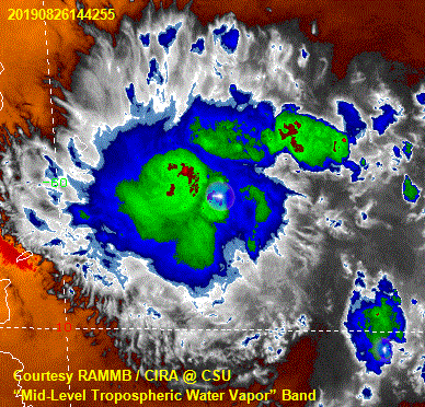
Is it healthy, or being squished from the north again? At first I thought northerly shear had picked back up but this might just be reorganization as the bands consolidate.
https://rammb-slider.cira.colostate.edu/?sat=goes-16&z=1&im=48&ts=1&st=0&et=0&speed=100&motion=loop&map=1&lat=0&opacity%5B0%5D=1&hidden%5B0%5D=0&pause=0&slider=-1&hide_controls=0&mouse_draw=0&follow_feature=0&follow_hide=0&s=rammb-slider&sec=mesoscale_02&p%5B0%5D=natural_color&x=952.940673828125&y=966.9375
https://rammb-slider.cira.colostate.edu/?sat=goes-16&z=1&im=48&ts=1&st=0&et=0&speed=100&motion=loop&map=1&lat=0&opacity%5B0%5D=1&hidden%5B0%5D=0&pause=0&slider=-1&hide_controls=0&mouse_draw=0&follow_feature=0&follow_hide=0&s=rammb-slider&sec=mesoscale_02&p%5B0%5D=natural_color&x=952.940673828125&y=966.9375
0 likes
M a r k
- - - - -
Join us in chat: Storm2K Chatroom Invite. Android and IOS apps also available.
The posts in this forum are NOT official forecasts and should not be used as such. Posts are NOT endorsed by any professional institution or STORM2K.org. For official information and forecasts, please refer to NHC and NWS products.
-
plasticup
Re: ATL: DORIAN - Tropical Storm - Discussion
Stronger --> rightward --> misses Hispaniola --> likely CONUS threat
3 likes
-
northjaxpro
- S2K Supporter
- Posts: 8900
- Joined: Mon Sep 27, 2010 11:21 am
- Location: Jacksonville, FL
Re: ATL: DORIAN - Tropical Storm - Discussion
plasticup wrote:Stronger --> rightward --> misses Hispaniola --> likely CONUS threat
To be straight-forward here, YES this is correct in a nutshell!
0 likes
NEVER, EVER SAY NEVER in the tropics and weather in general, and most importantly, with life itself!!
________________________________________________________________________________________
Fay 2008 Beryl 2012 Debby 2012 Colin 2016 Hermine 2016 Julia 2016 Matthew 2016 Irma 2017 Dorian 2019
________________________________________________________________________________________
Fay 2008 Beryl 2012 Debby 2012 Colin 2016 Hermine 2016 Julia 2016 Matthew 2016 Irma 2017 Dorian 2019
-
BYG Jacob
Re: ATL: DORIAN - Tropical Storm - Discussion
tolakram wrote:Is it healthy, or being squished from the north again? At first I thought northerly shear had picked back up but this might just be reorganization as the bands consolidate.
https://rammb-slider.cira.colostate.edu/?sat=goes-16&z=1&im=48&ts=1&st=0&et=0&speed=100&motion=loop&map=1&lat=0&opacity%5B0%5D=1&hidden%5B0%5D=0&pause=0&slider=-1&hide_controls=0&mouse_draw=0&follow_feature=0&follow_hide=0&s=rammb-slider&sec=mesoscale_02&p%5B0%5D=natural_color&x=952.940673828125&y=966.9375
Based on the outflow expanding to the north in that clip, I’d say reorganization
0 likes
Re: ATL: DORIAN - Tropical Storm - Discussion
Cirrus structure very indicative of an anticyclone directly overhead.
0 likes
-
tolakram
- Admin
- Posts: 20186
- Age: 62
- Joined: Sun Aug 27, 2006 8:23 pm
- Location: Florence, KY (name is Mark)
Re: ATL: DORIAN - Tropical Storm - Discussion
BYG Jacob wrote:tolakram wrote:Is it healthy, or being squished from the north again? At first I thought northerly shear had picked back up but this might just be reorganization as the bands consolidate.
https://rammb-slider.cira.colostate.edu/?sat=goes-16&z=1&im=48&ts=1&st=0&et=0&speed=100&motion=loop&map=1&lat=0&opacity%5B0%5D=1&hidden%5B0%5D=0&pause=0&slider=-1&hide_controls=0&mouse_draw=0&follow_feature=0&follow_hide=0&s=rammb-slider&sec=mesoscale_02&p%5B0%5D=natural_color&x=952.940673828125&y=966.9375
Based on the outflow expanding to the north in that clip, I’d say reorganization
In this case I think IR shows it best, just took a big gulp of dry air, which is making its way toward the center.
1 likes
M a r k
- - - - -
Join us in chat: Storm2K Chatroom Invite. Android and IOS apps also available.
The posts in this forum are NOT official forecasts and should not be used as such. Posts are NOT endorsed by any professional institution or STORM2K.org. For official information and forecasts, please refer to NHC and NWS products.
- - - - -
Join us in chat: Storm2K Chatroom Invite. Android and IOS apps also available.
The posts in this forum are NOT official forecasts and should not be used as such. Posts are NOT endorsed by any professional institution or STORM2K.org. For official information and forecasts, please refer to NHC and NWS products.
Who is online
Users browsing this forum: No registered users and 49 guests