ATL: DORIAN - Models

Moderator: S2k Moderators

Message
Author
User avatar
MetsIslesNoles
S2K Supporter
S2K Supporter
Posts: 64
Joined: Thu Jul 07, 2005 10:42 pm
Location: Tallahassee, FL

Re: ATL: DORIAN - Models

#781 Postby MetsIslesNoles » Tue Aug 27, 2019 12:21 pm

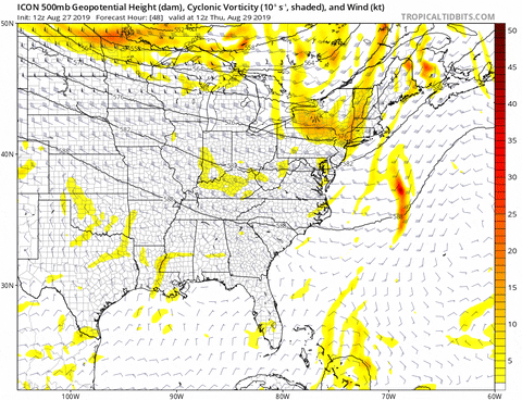
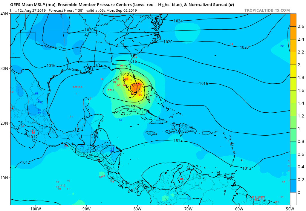
Siker wrote:GFS makes landfall Sunday afternoon and doesn't exit Florida until Friday evening when it heads offshore to the east.


It'll be a wonderful time in the panhandle if a solution like that occurs but a bit more south over the bay. I imagine it would be some epic flooding rains and with enough wind to (40-50 is plenty) to take out a lot of trees and power.
0 likes   

Kat5
Tropical Storm
Tropical Storm
Posts: 178
Joined: Tue Jul 07, 2009 5:28 pm

Re: ATL: DORIAN - Models

#782 Postby Kat5 » Tue Aug 27, 2019 12:29 pm

Just wanted to show how apparent the trend is, we can take the TVCN as an example.

Image
0 likes   

User avatar
StormLogic
Tropical Storm
Tropical Storm
Posts: 201
Joined: Mon Jun 03, 2019 9:58 am
Location: Beaumont

Re: ATL: DORIAN - Models

#783 Postby StormLogic » Tue Aug 27, 2019 12:31 pm

Image
icon takes dorian into gom where she hits some good fuel and grows bigger and then heads west
0 likes   
Personal Forecast Disclaimer:
The posts in this forum are NOT official forecast and should not be used as such. They are just the opinion of the poster and may or may not be backed by sound meteorological data. They are NOT endorsed by any professional institution or storm2k.org. For official information, please refer to the NHC and NWS products.

CrazyC83
Professional-Met
Professional-Met
Posts: 34002
Joined: Tue Mar 07, 2006 11:57 pm
Location: Deep South, for the first time!

Re: ATL: DORIAN - Models

#784 Postby CrazyC83 » Tue Aug 27, 2019 12:33 pm


Could it miss Puerto Rico to the right?
0 likes   

stormlover2013

Re: ATL: DORIAN - Models

#785 Postby stormlover2013 » Tue Aug 27, 2019 12:33 pm

Kat5 wrote:Just wanted to show how apparent the trend is, we can take the TVCN as an example.

http://www.atmos.albany.edu/facstaff/tang/tcguidance/al052019/tr13.png


There is no trend, wait till it gets passed the mountains for a trend, I have done this to long to say there is a trend 5-7 days out
1 likes   

User avatar
ObsessedMiami
Category 1
Category 1
Posts: 431
Joined: Tue Aug 31, 2004 8:08 pm
Location: West Kendall, Fl

Re: ATL: DORIAN - Models

#786 Postby ObsessedMiami » Tue Aug 27, 2019 12:35 pm

Kat5 wrote:
CourierPR wrote:
Kat5 wrote:
Wouldn’t doubt that at all, anybody north of Jupiter beach should keep tabs on this storm, it’s unlikely at this point for it to make a direct hit south of there. If you live in south Florida, still be weary as we still haven’t seen the peak of this season yet!


So your meteorological expertise now puts South Florida in the clear. Now I can rest easy tonight.


Hence the word “unlikely” never said cleared. And I’m not a meteorologist, just an outsider throwing in his two cents.


Whatever happened to the old disclaimer one had to use if they were posting their opinion and not a professional forecast?
I remember they used to be strict on that when storms threatened populated areas because some may log on only once and see that post and figure its all clear.
6 likes   

User avatar
chris_fit
Category 5
Category 5
Posts: 3222
Age: 42
Joined: Wed Sep 10, 2003 11:58 pm
Location: Tampa Bay Area, FL

Re: ATL: DORIAN - Models

#787 Postby chris_fit » Tue Aug 27, 2019 12:38 pm

Notable change in the GFS Ensembles - MUCH stronger - MUCH more defined W Bend

12Z
Image


06Z
Image
0 likes   

User avatar
Hammy
Category 5
Category 5
Posts: 5849
Age: 41
Joined: Fri May 25, 2012 5:25 pm
Contact:

Re: ATL: DORIAN - Models

#788 Postby Hammy » Tue Aug 27, 2019 12:39 pm

ObsessedMiami wrote:
Kat5 wrote:
CourierPR wrote:

So your meteorological expertise now puts South Florida in the clear. Now I can rest easy tonight.


Hence the word “unlikely” never said cleared. And I’m not a meteorologist, just an outsider throwing in his two cents.


Whatever happened to the old disclaimer one had to use if they were posting their opinion and not a professional forecast?
I remember they used to be strict on that when storms threatened populated areas because some may log on only once and see that post and figure its all clear.


If I remember correctly there were actual legal liability issues that prompted that in the first place and a later ruling rendered it unnecessary.
2 likes   
The above post is not official and should not be used as such. It is the opinion of the poster and may or may not be backed by sound meteorological data. It is not endorsed by any professional institution or storm2k.org. For official information, please refer to the NHC and NWS products.

User avatar
NotSparta
Professional-Met
Professional-Met
Posts: 1670
Age: 23
Joined: Fri Aug 18, 2017 8:24 am
Location: Naples, FL
Contact:

Re: ATL: DORIAN - Models

#789 Postby NotSparta » Tue Aug 27, 2019 12:41 pm

ObsessedMiami wrote:
Kat5 wrote:
CourierPR wrote:

So your meteorological expertise now puts South Florida in the clear. Now I can rest easy tonight.


Hence the word “unlikely” never said cleared. And I’m not a meteorologist, just an outsider throwing in his two cents.


It's on the top of the page
Whatever happened to the old disclaimer one had to use if they were posting their opinion and not a professional forecast?
I remember they used to be strict on that when storms threatened populated areas because some may log on only once and see that post and figure its all clear.
.

The disclaimer is still there, at the top
Last edited by NotSparta on Tue Aug 27, 2019 12:44 pm, edited 1 time in total.
2 likes   
This post was probably an opinion of mine, and in no way is official. Please refer to http://www.hurricanes.gov for official tropical analysis and advisories.

My website, with lots of tropical wx graphics, including satellite and recon: http://cyclonicwx.com

User avatar
Evil Jeremy
S2K Supporter
S2K Supporter
Posts: 5463
Age: 32
Joined: Mon Apr 10, 2006 2:10 pm
Location: Los Angeles, CA

Re: ATL: DORIAN - Models

#790 Postby Evil Jeremy » Tue Aug 27, 2019 12:42 pm

:uarrow: Not what I was expecting from the ensembles given the jump N from the operational. Between those ensembles, ICON, and the weird UKMET dive WSW at day 5, it’s clear Dorian will be shoved west eventually. I wonder if there’s a hypothetical limit to how far N it can get before feeling the ridge. And also, how would a stronger Dorian that misses Hispaniola to the E interact with the ridge.
0 likes   
Frances 04 / Jeanne 04 / Katrina 05 / Wilma 05 / Fay 08 / Debby 12 / Andrea 13 / Colin 16 / Hermine 16 / Matthew 16 / Irma 17

User avatar
toad strangler
S2K Supporter
S2K Supporter
Posts: 4543
Joined: Sun Jul 28, 2013 3:09 pm
Location: Earth
Contact:

Re: ATL: DORIAN - Models

#791 Postby toad strangler » Tue Aug 27, 2019 12:43 pm

Some of already said it before. Nothing ever good comes from a track like this historically. #UKMET

 https://twitter.com/hurrtrackerapp/status/1166392770766036994


0 likes   

tolakram
Admin
Admin
Posts: 20009
Age: 62
Joined: Sun Aug 27, 2006 8:23 pm
Location: Florence, KY (name is Mark)

Re: ATL: DORIAN - Models

#792 Postby tolakram » Tue Aug 27, 2019 12:45 pm

I'm starting to get concerned about a stall and flooding. A non sexy storm hitting and stalling is extremely dangerous. UK sends it southwest, GFS stalls the vorticity over the panhandle, and GFS legacy has it meandering over Ga and the panhandle. The 0Z Euro washing out the vorticity but also shows it lingering.

This is still very far out but something to watch.

Image
1 likes   
M a r k
- - - - -
Join us in chat: Storm2K Chatroom Invite. Android and IOS apps also available.

The posts in this forum are NOT official forecasts and should not be used as such. Posts are NOT endorsed by any professional institution or STORM2K.org. For official information and forecasts, please refer to NHC and NWS products.

tolakram
Admin
Admin
Posts: 20009
Age: 62
Joined: Sun Aug 27, 2006 8:23 pm
Location: Florence, KY (name is Mark)

Re: ATL: DORIAN - Models

#793 Postby tolakram » Tue Aug 27, 2019 12:46 pm

12Z Euro init
Image
1 likes   
M a r k
- - - - -
Join us in chat: Storm2K Chatroom Invite. Android and IOS apps also available.

The posts in this forum are NOT official forecasts and should not be used as such. Posts are NOT endorsed by any professional institution or STORM2K.org. For official information and forecasts, please refer to NHC and NWS products.

User avatar
robbielyn
Category 5
Category 5
Posts: 1298
Joined: Wed May 07, 2003 9:45 am
Location: brooksville, fl

Re: ATL: DORIAN - Models

#794 Postby robbielyn » Tue Aug 27, 2019 12:46 pm

toad strangler wrote:
Evil Jeremy wrote:I disagree with the assessment that there's no trend. There has been a notable trend to the north and east over the past 12 hours. I'm just not convinced it will stick. GFS, UKMET, ICON, CMC have all made those adjustments this cycle. I agree with the toad strangler though, it's a crapshoot at the moment.


Fair enough. In my eyes none of these model runs matter until Dorian or whats left of him actually clear the GA's.
what’s GA?
0 likes   
Robbielyn McCrary
I know just about enough to sound like I know what I'm talking about sometimes. But for your safety please follow the nhc for truly professional forecasting. :D

User avatar
toad strangler
S2K Supporter
S2K Supporter
Posts: 4543
Joined: Sun Jul 28, 2013 3:09 pm
Location: Earth
Contact:

Re: ATL: DORIAN - Models

#795 Postby toad strangler » Tue Aug 27, 2019 12:48 pm

robbielyn wrote:
toad strangler wrote:
Evil Jeremy wrote:I disagree with the assessment that there's no trend. There has been a notable trend to the north and east over the past 12 hours. I'm just not convinced it will stick. GFS, UKMET, ICON, CMC have all made those adjustments this cycle. I agree with the toad strangler though, it's a crapshoot at the moment.


Fair enough. In my eyes none of these model runs matter until Dorian or whats left of him actually clear the GA's.
what’s GA?


Greater Antilles
0 likes   

User avatar
AdamFirst
S2K Supporter
S2K Supporter
Posts: 2491
Age: 36
Joined: Thu Aug 14, 2008 10:54 am
Location: Port Saint Lucie, FL

Re: ATL: DORIAN - Models

#796 Postby AdamFirst » Tue Aug 27, 2019 12:48 pm

robbielyn wrote:what’s GA?


The Greater Antilles - Puerto Rico and Hispaniola
0 likes   
Dolphins Marlins Canes Golden Panthers HEAT
Andrew 1992 - Irene 1999 - Frances 2004 - Jeanne 2004 - Wilma 2005 - Fay 2008 - Isaac 2012 - Matthew 2016 - Irma 2017 - Dorian 2019 - Ian 2022 - Nicole 2022 - Milton 2024

CrazyC83
Professional-Met
Professional-Met
Posts: 34002
Joined: Tue Mar 07, 2006 11:57 pm
Location: Deep South, for the first time!

Re: ATL: DORIAN - Models

#797 Postby CrazyC83 » Tue Aug 27, 2019 12:48 pm

A stall over the Labor Day weekend would be a business disaster even if it is a weak storm. Yet it is looking very possible...it will be hard pressed to go north in the eastern Gulf, while if a ridge blocks to the west...I wonder if the models are on to something?

Do they account for the new center though?
0 likes   

User avatar
Kohlecane
Category 2
Category 2
Posts: 593
Age: 33
Joined: Sun Jul 31, 2011 11:03 pm
Location: Beaufort, SC

Re: ATL: DORIAN - Models

#798 Postby Kohlecane » Tue Aug 27, 2019 12:48 pm

Euro Initialized A tad bit south IMO!
0 likes   
Once I see the REDS and GREENS Converge on a Base Velocity. ... I'm There!!

This is NOT an Official Forecast....Just my Opinion. For official information, please refer to the NHC and NWS products.
HIGHLIGHTS : '13 El Reno Tornado : 2013 Storm Chaser Tour, Joaquin; SC flood event, Matthew '16, Lowcountry Snow storm Jan '18

User avatar
gatorcane
S2K Supporter
S2K Supporter
Posts: 23691
Age: 47
Joined: Sun Mar 13, 2005 3:54 pm
Location: Boca Raton, FL

Re: ATL: DORIAN - Models

#799 Postby gatorcane » Tue Aug 27, 2019 12:49 pm

Look at all of these GFS ensembles zeroing in on SE Florida also they are coming in stronger. By no means is South Florida in the clear. Let us hope the big islands can severely disrupt Dorian:

Image
Last edited by gatorcane on Tue Aug 27, 2019 12:52 pm, edited 1 time in total.
5 likes   

User avatar
La Sirena
Category 1
Category 1
Posts: 307
Joined: Sun Aug 21, 2016 4:02 pm
Location: Formerly of the Keys, back home in East TN

Re: ATL: DORIAN - Models

#800 Postby La Sirena » Tue Aug 27, 2019 12:52 pm

ObsessedMiami wrote:
Kat5 wrote:
CourierPR wrote:

So your meteorological expertise now puts South Florida in the clear. Now I can rest easy tonight.


Hence the word “unlikely” never said cleared. And I’m not a meteorologist, just an outsider throwing in his two cents.


Whatever happened to the old disclaimer one had to use if they were posting their opinion and not a professional forecast?
I remember they used to be strict on that when storms threatened populated areas because some may log on only once and see that post and figure its all clear.

Was wondering the same thing myself.
0 likes   
The posts in this forum are NOT official forecasts and should not be used as such. They are just the opinion of the poster and may or may not be backed by sound meteorological data. They are NOT endorsed by any professional institution or STORM2K. For official information, please refer to products from the NHC and NWS.


Return to “2019”

Who is online

Users browsing this forum: No registered users and 4 guests