
ATL: DORIAN - Models
Moderator: S2k Moderators
-
tolakram
- Admin

- Posts: 20186
- Age: 62
- Joined: Sun Aug 27, 2006 8:23 pm
- Location: Florence, KY (name is Mark)
Re: ATL: DORIAN - Models
0 likes
M a r k
- - - - -
Join us in chat: Storm2K Chatroom Invite. Android and IOS apps also available.
The posts in this forum are NOT official forecasts and should not be used as such. Posts are NOT endorsed by any professional institution or STORM2K.org. For official information and forecasts, please refer to NHC and NWS products.
-
AubreyStorm

- Category 1

- Posts: 337
- Age: 45
- Joined: Fri Jun 16, 2017 6:21 pm
- Location: Texas, USA
Re: ATL: DORIAN - Models
0 likes
The posts are NOT an official forecast. Please REFER to the NHC and NWS for official forecasts and products.


Re: ATL: DORIAN - Models
CrazyC83 wrote:A stall over the Labor Day weekend would be a business disaster even if it is a weak storm. Yet it is looking very possible...it will be hard pressed to go north in the eastern Gulf, while if a ridge blocks to the west...I wonder if the models are on to something?
Do they account for the new center though?
Not very likely given it's such a small scale feature and it only happened around 15z. Maybe some higher res models will pick up on it though.
0 likes
-
tolakram
- Admin
- Posts: 20186
- Age: 62
- Joined: Sun Aug 27, 2006 8:23 pm
- Location: Florence, KY (name is Mark)
Re: ATL: DORIAN - Models
Barely a tropical storm.
1 likes
M a r k
- - - - -
Join us in chat: Storm2K Chatroom Invite. Android and IOS apps also available.
The posts in this forum are NOT official forecasts and should not be used as such. Posts are NOT endorsed by any professional institution or STORM2K.org. For official information and forecasts, please refer to NHC and NWS products.
- - - - -
Join us in chat: Storm2K Chatroom Invite. Android and IOS apps also available.
The posts in this forum are NOT official forecasts and should not be used as such. Posts are NOT endorsed by any professional institution or STORM2K.org. For official information and forecasts, please refer to NHC and NWS products.
-
TheProfessor

- Professional-Met

- Posts: 3506
- Age: 29
- Joined: Tue Dec 03, 2013 10:56 am
- Location: Wichita, Kansas
Re: ATL: DORIAN - Models
12z HMON has a Cat 1 hurricane into Miami
4 likes
An alumnus of The Ohio State University.
Your local National Weather Service office is your best source for weather information.
Your local National Weather Service office is your best source for weather information.


Re: ATL: DORIAN - Models
toad strangler wrote:robbielyn wrote:what’s GA?toad strangler wrote:
Fair enough. In my eyes none of these model runs matter until Dorian or whats left of him actually clear the GA's.
Greater Antilles
oh ok i was so focused on it passing through the mona and maybe hispaniola is part of the GA, i was racking my brain trying to figure it out and decided to embarrass myself by asking it publicly vs. pm’ing you. but now i know.
0 likes
Robbielyn McCrary
I know just about enough to sound like I know what I'm talking about sometimes. But for your safety please follow the nhc for truly professional forecasting.
I know just about enough to sound like I know what I'm talking about sometimes. But for your safety please follow the nhc for truly professional forecasting.

Re: ATL: DORIAN - Models
tolakram wrote:I'm starting to get concerned about a stall and flooding. A non sexy storm hitting and stalling is extremely dangerous. UK sends it southwest, GFS stalls the vorticity over the panhandle, and GFS legacy has it meandering over Ga and the panhandle. The 0Z Euro washing out the vorticity but also shows it lingering.
This is still very far out but something to watch.
https://i.imgur.com/Qd316Tq.png
Does that show up to 2 feet of rain over Jax?
0 likes
-
SFLcane

- S2K Supporter

- Posts: 10281
- Age: 48
- Joined: Sat Jun 05, 2010 1:44 pm
- Location: Lake Worth Florida
Re: ATL: DORIAN - Models
TheProfessor wrote:12z HMON has a Cat 1 hurricane into Miami
Big change there... was not really developing Dorian previously.
2 likes

Re: ATL: DORIAN - Models
The 12Z HWRF is showing the effects of shear and high terrain near Hispaniola.
There is currently an upper level circulation north of Hispaniola that would impart shear from the west if it persists. So beyond that issue its going to be difficult to forecast, if Dorian weakens south of the Dominican Republic it could even dissipate.
There is currently an upper level circulation north of Hispaniola that would impart shear from the west if it persists. So beyond that issue its going to be difficult to forecast, if Dorian weakens south of the Dominican Republic it could even dissipate.
1 likes
-
gatorcane

- S2K Supporter
- Posts: 23708
- Age: 48
- Joined: Sun Mar 13, 2005 3:54 pm
- Location: Boca Raton, FL
Re: ATL: DORIAN - Models
12Z NAVGEM into Miami / SE Florida:
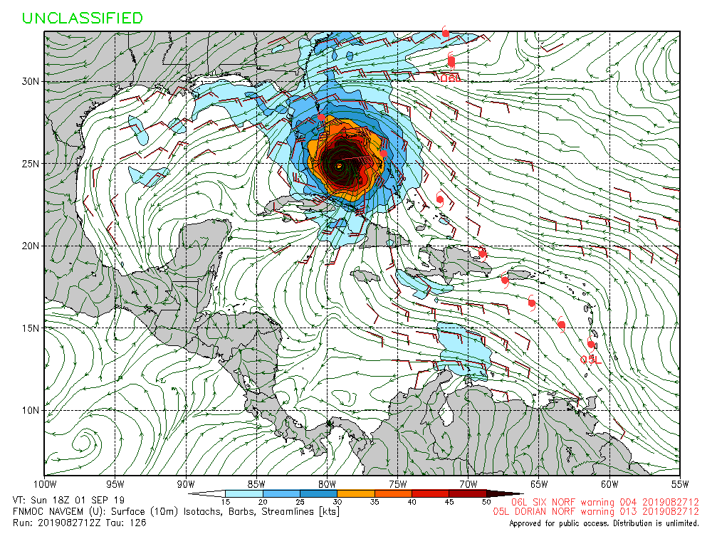
Last edited by gatorcane on Tue Aug 27, 2019 1:03 pm, edited 1 time in total.
1 likes
-
tolakram
- Admin
- Posts: 20186
- Age: 62
- Joined: Sun Aug 27, 2006 8:23 pm
- Location: Florence, KY (name is Mark)
Re: ATL: DORIAN - Models

0 likes
M a r k
- - - - -
Join us in chat: Storm2K Chatroom Invite. Android and IOS apps also available.
The posts in this forum are NOT official forecasts and should not be used as such. Posts are NOT endorsed by any professional institution or STORM2K.org. For official information and forecasts, please refer to NHC and NWS products.
- - - - -
Join us in chat: Storm2K Chatroom Invite. Android and IOS apps also available.
The posts in this forum are NOT official forecasts and should not be used as such. Posts are NOT endorsed by any professional institution or STORM2K.org. For official information and forecasts, please refer to NHC and NWS products.

-
TheProfessor
- Professional-Met
- Posts: 3506
- Age: 29
- Joined: Tue Dec 03, 2013 10:56 am
- Location: Wichita, Kansas
Re: ATL: DORIAN - Models
The 12z HWRF has a WSW moving hurricane making landfall on the central Florida coast.
Edited for correction.
Edited for correction.
Last edited by TheProfessor on Tue Aug 27, 2019 1:26 pm, edited 1 time in total.
0 likes
An alumnus of The Ohio State University.
Your local National Weather Service office is your best source for weather information.
Your local National Weather Service office is your best source for weather information.
-
AdamFirst

- S2K Supporter
- Posts: 2490
- Age: 36
- Joined: Thu Aug 14, 2008 10:54 am
- Location: Port Saint Lucie, FL
Re: ATL: DORIAN - Models
NAVGEM has been extremely consistent from run to run with a landfall down in SFL. For what it's worth, anyway
0 likes
Dolphins Marlins Canes Golden Panthers HEAT
Andrew 1992 - Irene 1999 - Frances 2004 - Jeanne 2004 - Wilma 2005 - Fay 2008 - Isaac 2012 - Matthew 2016 - Irma 2017 - Dorian 2019 - Ian 2022 - Nicole 2022 - Milton 2024
Andrew 1992 - Irene 1999 - Frances 2004 - Jeanne 2004 - Wilma 2005 - Fay 2008 - Isaac 2012 - Matthew 2016 - Irma 2017 - Dorian 2019 - Ian 2022 - Nicole 2022 - Milton 2024


-
Evil Jeremy

- S2K Supporter
- Posts: 5463
- Age: 32
- Joined: Mon Apr 10, 2006 2:10 pm
- Location: Los Angeles, CA
Re: ATL: DORIAN - Models
TheProfessor wrote:12z HMON has a Cat 1 hurricane into Miami
I'm not familiar with the HMON's reliability, but I can say this is the first run of it's past four that hits mainland FL. All the others were into the Keys or Straits.
0 likes
Frances 04 / Jeanne 04 / Katrina 05 / Wilma 05 / Fay 08 / Debby 12 / Andrea 13 / Colin 16 / Hermine 16 / Matthew 16 / Irma 17

Re: ATL: DORIAN - Models
Wow Big shift N @ 72 hours from the 00z to 12z Euro.
Also what's a good link for HMON 12z
Also what's a good link for HMON 12z
0 likes
Once I see the REDS and GREENS Converge on a Base Velocity. ... I'm There!!
This is NOT an Official Forecast....Just my Opinion. For official information, please refer to the NHC and NWS products.
HIGHLIGHTS : '13 El Reno Tornado : 2013 Storm Chaser Tour, Joaquin; SC flood event, Matthew '16, Lowcountry Snow storm Jan '18
This is NOT an Official Forecast....Just my Opinion. For official information, please refer to the NHC and NWS products.
HIGHLIGHTS : '13 El Reno Tornado : 2013 Storm Chaser Tour, Joaquin; SC flood event, Matthew '16, Lowcountry Snow storm Jan '18
-
tolakram
- Admin
- Posts: 20186
- Age: 62
- Joined: Sun Aug 27, 2006 8:23 pm
- Location: Florence, KY (name is Mark)
Re: ATL: DORIAN - Models
Kohlecane wrote:Wow Big shift N @ 72 hours from the 00z to 12z Euro.
Also what's a good link for HMON 12z
Tropical Tidbits for almost all models.
https://www.tropicaltidbits.com/analysis/models/?model=hmon®ion=05L&pkg=mslp_wind&runtime=2019082712&fh=72
0 likes
M a r k
- - - - -
Join us in chat: Storm2K Chatroom Invite. Android and IOS apps also available.
The posts in this forum are NOT official forecasts and should not be used as such. Posts are NOT endorsed by any professional institution or STORM2K.org. For official information and forecasts, please refer to NHC and NWS products.
- - - - -
Join us in chat: Storm2K Chatroom Invite. Android and IOS apps also available.
The posts in this forum are NOT official forecasts and should not be used as such. Posts are NOT endorsed by any professional institution or STORM2K.org. For official information and forecasts, please refer to NHC and NWS products.
Re: ATL: DORIAN - Models
tolakram wrote:https://i.imgur.com/cyUjiXp.png
Dorian being that close to hispaniola probably will beat it up a little but maybe not too bad since it’s a weak storm to begin with. stronger storms really get more affected although can survive if offshore.
0 likes
Robbielyn McCrary
I know just about enough to sound like I know what I'm talking about sometimes. But for your safety please follow the nhc for truly professional forecasting.
I know just about enough to sound like I know what I'm talking about sometimes. But for your safety please follow the nhc for truly professional forecasting.
-
TheProfessor
- Professional-Met
- Posts: 3506
- Age: 29
- Joined: Tue Dec 03, 2013 10:56 am
- Location: Wichita, Kansas
Re: ATL: DORIAN - Models
Kohlecane wrote:Wow Big shift N @ 72 hours from the 00z to 12z Euro.
Also what's a good link for HMON 12z
https://tropicaltidbits.com/analysis/mo ... 82712&fh=6
0 likes
An alumnus of The Ohio State University.
Your local National Weather Service office is your best source for weather information.
Your local National Weather Service office is your best source for weather information.
Who is online
Users browsing this forum: No registered users and 20 guests