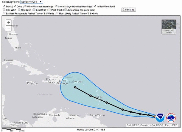
Track from 5pm TPC has a new attraction at Disney World.
Hurricane Dorian.
ATL: DORIAN - Post-Tropical - Discussion
Moderator: S2k Moderators
-
OuterBanker
- S2K Supporter

- Posts: 1761
- Joined: Wed Feb 26, 2003 10:53 am
- Location: Nags Head, NC
- Contact:
-
SconnieCane
- Category 5

- Posts: 1013
- Joined: Thu Aug 02, 2018 5:29 pm
- Location: Madison, WI
Re: ATL: DORIAN - Hurricane - Discussion
Highteeld wrote:drewschmaltz wrote:If atmospheric conditions are prime, why then are intensity forecasts not cat 4 winds? I'm sincerely interested, what conditions did say Andrew have that Dorian does not? Are the SSTs not high enough? Does it not have enough ventilation? Too high of shear? I thought with the setup these are all expected to be favorable... What's capping only a 35mph increase from right this minute.
hwrf sees it. same issue happened with michael last year. most models are initiated it wayyyyy too weak right now
HWRF is usually the outlier with extreme intensities, but occasionally it is on to something. NHC usually plays it conservative with intensity forecasts unless there is clear RI in progress.
0 likes
-
Kingarabian

- S2K Supporter
- Posts: 16344
- Joined: Sat Aug 08, 2009 3:06 am
- Location: Honolulu, Hawaii
Re: ATL: DORIAN - Hurricane - Discussion
Almost a complete eyewall now:

Rate its going, probably see a firmly closed eyewall in about 6 hours. After that we can expect the eye to clear out. Also this is not a pinhole eye-type.
Rate its going, probably see a firmly closed eyewall in about 6 hours. After that we can expect the eye to clear out. Also this is not a pinhole eye-type.
7 likes
RIP Kobe Bryant
-
jasons2k

- Storm2k Executive

- Posts: 8290
- Age: 52
- Joined: Wed Jul 06, 2005 12:32 pm
- Location: The Woodlands, TX
Re: ATL: DORIAN - Hurricane - Discussion
SoupBone wrote:HurricaneBelle wrote:Surprised nobody's seemed to notice the 5PM advisory has been out for about ten minutes, it's now being taken across Vero, hooking up with I-4 in the central part of the State.
Here in Tampa our probabilities went up from 36/11/5 to 62/31/17 in the space of one advisory interval.
Has Tampa ever been hit by a major coming from East to West like this?
Not in the historical record, no. And that would be nearly impossible. Not totally impossible - but pretty close.
The most recent major to impact the Tampa Bay Area directly was the 1921 hurricane, making landfall near Tarpon Springs.
1 likes

Re: ATL: DORIAN - Hurricane - Discussion
OuterBanker wrote:Track from 5pm TPC has a new attraction at Disney World.
Hurricane Dorian.
This weekend was the opening of Galaxys Edge here at WDW. Plus the holiday weekend.
4 likes
-
supercane4867
- Category 5
- Posts: 4966
- Joined: Wed Nov 14, 2012 10:43 am
-
weathaguyry

- Category 5
- Posts: 1273
- Age: 22
- Joined: Wed Jun 15, 2016 5:16 am
- Location: Long Island, NY
Re: ATL: DORIAN - Hurricane - Discussion
My sister is currently at UMiami in Coral Gables, many of the parents are nervous and flying their kids home. I think with the SFL building codes that a college campus may be a decent location to ride out a hurricane, especially since they will have priority in getting power restored and getting resources. Either way we shall see if the trend south continues, as Dorian seems pretty angry right now...
1 likes
My posts are only my opinions and NOT official forecasts. For official forecasts, consult the National Hurricane Center or the National Weather Service.
Irene 11', Sandy 12', Fay 20’, Isaias 20’, Elsa 21’, Henri 21’, Ida 21’
Irene 11', Sandy 12', Fay 20’, Isaias 20’, Elsa 21’, Henri 21’, Ida 21’

Re: ATL: DORIAN - Hurricane - Discussion
Dorian strengthening earlier than expected will lead to more EWRCs in the long run. This will cause him to expand quite a bit over the next few days- think about how much bigger Irma got from when it first became a hurricane in the eastern MDR to when it made landfall in Florida.
2 likes
Igor 2010, Sandy 2012, Fay 2014, Gonzalo 2014, Joaquin 2015, Nicole 2016, Humberto 2019, Imelda 2025
I am only a tropical weather enthusiast. My predictions are not official and may or may not be backed by sound meteorological data. For official information, please refer to the NHC and NWS products.
I am only a tropical weather enthusiast. My predictions are not official and may or may not be backed by sound meteorological data. For official information, please refer to the NHC and NWS products.
-
HurricaneBelle

- S2K Supporter
- Posts: 1209
- Joined: Sun Aug 27, 2006 6:12 pm
- Location: Clearwater, FL
Re: ATL: DORIAN - Hurricane - Discussion
SoupBone wrote:HurricaneBelle wrote:Surprised nobody's seemed to notice the 5PM advisory has been out for about ten minutes, it's now being taken across Vero, hooking up with I-4 in the central part of the State.
Here in Tampa our probabilities went up from 36/11/5 to 62/31/17 in the space of one advisory interval.
Has Tampa ever been hit by a major coming from East to West like this?
Not something that held as a 3 or better coming "backdoor" across the state. In 04, Frances and Jeanne were strong TSs when they made it here, but if Dorian hits as a 4 or 5 on the east coast, it could be a 1 or a 2 over here.
0 likes
-
supercane4867
- Category 5
- Posts: 4966
- Joined: Wed Nov 14, 2012 10:43 am
Re: ATL: DORIAN - Hurricane - Discussion
The current position of Dorian is actually way outside of previous 5 day cones.
7 likes
-
BYG Jacob
Re: ATL: DORIAN - Hurricane - Discussion
Kingarabian wrote:Almost a complete eyewall now:
https://i.imgur.com/SKPFXGB.jpg
Rate its going, probably see a firmly closed eyewall in about 6 hours. After that we can expect the eye to clear out. Also this is not a pinhole eye-type.
By the time he gets his eyewall sorted he might be a major.
0 likes
-
HurricaneBelle
- S2K Supporter
- Posts: 1209
- Joined: Sun Aug 27, 2006 6:12 pm
- Location: Clearwater, FL
Re: ATL: DORIAN - Hurricane - Discussion
cjrciadt wrote:OuterBanker wrote:Track from 5pm TPC has a new attraction at Disney World.
Hurricane Dorian.

This weekend was the opening of Galaxys Edge here at WDW. Plus the holiday weekend.
Maybe they can quickly convert it into a "Hurricane Heist" attraction like that movie from last year.
0 likes
-
p1nheadlarry

- Category 2

- Posts: 672
- Age: 34
- Joined: Wed Jan 29, 2014 2:42 pm
- Location: SR County FL
Re: ATL: DORIAN - Hurricane - Discussion
weathaguyry wrote:My sister is currently at UMiami in Coral Gables, many of the parents are nervous and flying their kids home. I think with the SFL building codes that a college campus may be a decent location to ride out a hurricane, especially since they will have priority in getting power restored and getting resources. Either way we shall see if the trend south continues, as Dorian seems pretty angry right now...
Some colleges kick everyone out of the dorms, even at the coast. For example this blew up for UNC-Wilmington during Matthew, because they opened classes and kids coming back got trapped by floodwaters.
1 likes
--;->#GoNoles--;->.

Re: ATL: DORIAN - Hurricane - Discussion
could be as high as 90 mph right now

5 likes
Very useful information on the Dvorak Technique --
https://severe.worldweather.wmo.int/TCF ... kBeven.pdf
https://severe.worldweather.wmo.int/TCF ... kBeven.pdf
-
drewschmaltz
- S2K Supporter
- Posts: 351
- Joined: Thu Aug 27, 2015 8:19 pm
Re: ATL: DORIAN - Hurricane - Discussion
supercane4867 wrote:The current position of Dorian is actually way outside of previous 5 day cones.
https://uploads.disquscdn.com/images/ac8f014b53a123276bfff4d68494d0b89b8ccce685793b5c884600e23185814b.gif
I rarely bring up analogs due to my limited knowledge. But being from Florida born in the early 80s and being named Andrew, I've always paid attention to it.
Is it JUST me or is the remainder of this track and setup way way too much like Andrew?
2 likes
I HAVE ABSOLUTELY NO IDEA WHAT I'M TALKING ABOUT. PLEASE CONSULT SOMEONE WHO DOES. START WITH THE NHC. ALL POSTS ARE FOR ENTERTAINMENT PURPOSES ONLY.

Re: ATL: DORIAN - Hurricane - Discussion
drewschmaltz wrote:supercane4867 wrote:The current position of Dorian is actually way outside of previous 5 day cones.
https://uploads.disquscdn.com/images/ac8f014b53a123276bfff4d68494d0b89b8ccce685793b5c884600e23185814b.gif
I rarely bring up analogs due to my limited knowledge. But being from Florida born in the early 80s and being named Andrew, I've always paid attention to it.
Is it JUST me or is the remainder of this track and setup way way too much like Andrew?
Andrew was way NE of this. Curved north well before it ever got the the islands. Then headed due west for several days.
0 likes
-
Bocadude85

- Category 5
- Posts: 2991
- Age: 39
- Joined: Mon Apr 18, 2005 2:20 pm
- Location: Honolulu,Hi
Re: ATL: DORIAN - Hurricane - Discussion
drewschmaltz wrote:supercane4867 wrote:The current position of Dorian is actually way outside of previous 5 day cones.
https://uploads.disquscdn.com/images/ac8f014b53a123276bfff4d68494d0b89b8ccce685793b5c884600e23185814b.gif
I rarely bring up analogs due to my limited knowledge. But being from Florida born in the early 80s and being named Andrew, I've always paid attention to it.
Is it JUST me or is the remainder of this track and setup way way too much like Andrew?
Based upon modeling, Andrew, 1947 Ft.Lauderdale hurricane, Betsy, Dora are all ok analogs for Dorian track wise once east of the Bahamas.
0 likes

Re: ATL: DORIAN - Hurricane - Discussion
5 likes
// Opinions are my own, I am not a Meteorologist. Consult the NHC or Local NWS and Emergency Management for current information in your area. //
-
StormPyrate
- Category 1

- Posts: 286
- Joined: Sun May 27, 2018 8:41 pm
- Location: Clearwater, FL
Re: ATL: DORIAN - Hurricane - Discussion
Is there still a satellite loop that you can overly the official track on? I sure miss the old floaters the new sliders are great but don't see how to overlay the track
0 likes
St Petersburg Florida
Who is online
Users browsing this forum: No registered users and 13 guests