ATL: DORIAN - Post-Tropical - Discussion
Moderator: S2k Moderators

Re: ATL: DORIAN - Hurricane - Discussion
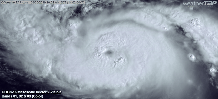
Just a few hours ago I thought the satellite appearance was pretty poor for a high-end cat 2. Turns out, all it needed was an eye.
2 likes
Igor 2010, Sandy 2012, Fay 2014, Gonzalo 2014, Joaquin 2015, Nicole 2016, Humberto 2019, Imelda 2025
I am only a tropical weather enthusiast. My predictions are not official and may or may not be backed by sound meteorological data. For official information, please refer to the NHC and NWS products.
I am only a tropical weather enthusiast. My predictions are not official and may or may not be backed by sound meteorological data. For official information, please refer to the NHC and NWS products.
-
supercane4867
- Category 5

- Posts: 4966
- Joined: Wed Nov 14, 2012 10:43 am
-
Dylan

- Professional-Met

- Posts: 338
- Age: 31
- Joined: Mon May 31, 2010 9:50 am
- Location: New Orleans, LA
Re: ATL: DORIAN - Hurricane - Discussion
2 likes
Georges('98), Allison('01), Isidore('02), Lili('02), Frances('04) Ivan('04), Cindy('05), Katrina('05), Rita('05), Gustav('08), Isaac('12), Matthew('16), Harvey('17), Irma('17), Nate ('17), Ida ('21).
-
EquusStorm
- Category 5
- Posts: 1649
- Age: 35
- Joined: Thu Nov 07, 2013 1:04 pm
- Location: Jasper, AL
- Contact:
Re: ATL: DORIAN - Hurricane - Discussion
Yeah I've been thinking of Hugo too. Same NW to SE stretch.
0 likes
Colors of lost purpose on the canvas of irrelevance
Not a meteorologist, in fact more of an idiot than anything. You should probably check with the NHC or a local NWS office for official information.
Not a meteorologist, in fact more of an idiot than anything. You should probably check with the NHC or a local NWS office for official information.

Re: ATL: DORIAN - Hurricane - Discussion
This could be the beginning of RI.
Heavy lightning on the eyewall tower.

Heavy lightning on the eyewall tower.
3 likes
ATL: DORIAN - Hurricane - Discussion
The flatness on top of Dorian bespeaks a hard ridge...I think it looks like it is turning early although there could be some -removed- involved...
Too close for comfort and have to act like it is coming here now...
1947 Ft Lauderdale hurricane followed same track, exited over Sanibel and had 120mph gust at lighthouse...
Too close for comfort and have to act like it is coming here now...
1947 Ft Lauderdale hurricane followed same track, exited over Sanibel and had 120mph gust at lighthouse...
1 likes
-
northjaxpro

- S2K Supporter

- Posts: 8900
- Joined: Mon Sep 27, 2010 11:21 am
- Location: Jacksonville, FL
Re: ATL: DORIAN - Hurricane - Discussion
jasons wrote:Yes, the eye clearing is concerning but almost more concerning when I look at the satellite loops is the improved cirrus outflow presentation in all directions now. An ominous sign indeed.
Yep. The visible satellite image of Dorian shows the cirrus outflow in all quadrants is actually a beautiful, but strikingly frightening image, one which is unquestionably signaling an intensifying tropical cyclone.
1 likes
NEVER, EVER SAY NEVER in the tropics and weather in general, and most importantly, with life itself!!
________________________________________________________________________________________
Fay 2008 Beryl 2012 Debby 2012 Colin 2016 Hermine 2016 Julia 2016 Matthew 2016 Irma 2017 Dorian 2019
________________________________________________________________________________________
Fay 2008 Beryl 2012 Debby 2012 Colin 2016 Hermine 2016 Julia 2016 Matthew 2016 Irma 2017 Dorian 2019
-
FLpanhandle91

- Category 5
- Posts: 1039
- Age: 34
- Joined: Mon Sep 13, 2010 3:50 pm
- Location: Fort Walton Beach, FL
Re: ATL: DORIAN - Hurricane - Discussion
NDG wrote:FLpanhandle91 wrote:93kt SFMR unflagged in the southwest quad.
Not enough for upgrade to Cat 3.
Agreed. Appears AF302 found that wind flying through the hot tower firing up on the southwest side. Once that deep convection wraps around to the northeast side, we will begin seeing winds supporting 100kt. Maybe 4 or so more hours.
Last edited by FLpanhandle91 on Fri Aug 30, 2019 9:39 am, edited 1 time in total.
1 likes

Re: ATL: DORIAN - Hurricane - Discussion
That eye is terrifying... bai god. Pressure is going to plummet and winds will follow. Cat 3 at least by tonight.
1 likes
-
BLUEBIRDFLA

- Tropical Wave

- Posts: 5
- Joined: Wed Oct 05, 2016 8:17 pm
- Location: South Florida
Re: ATL: DORIAN - Hurricane - Discussion
Wherever Dorian ends up makes landfall, where will the strongest winds be? To the north or south, east of the core? Thanks.
0 likes
Re: ATL: DORIAN - Hurricane - Discussion
Hello! Can someone post Dorian's current size, please? I am particularly interested to know how many wiles wide. I do understand it may be growing in size as it strengthens. Is there somewhere I can easily get this information on my own? I skimmed back a few pages but didn't see any reference to it.
I would also love to see the cone progression gif too if anyone has that handy.
I'm at work biting my nails. Little Ole Seminole County here, about 60 miles from the east coast. Hoping the best for everyone. xo
I would also love to see the cone progression gif too if anyone has that handy.
I'm at work biting my nails. Little Ole Seminole County here, about 60 miles from the east coast. Hoping the best for everyone. xo
1 likes
-
dexterlabio
- Category 5
- Posts: 3499
- Joined: Sat Oct 24, 2009 11:50 pm
Re: ATL: DORIAN - Hurricane - Discussion
Atlantic canes have some weird shape... I remember Matthew in 2016 being heart-shaped at its peak. 
5 likes
Personal Forecast Disclaimer:
The posts in this forum are NOT official forecast and should not be used as such. They are just the opinion of the poster and may or may not be backed by sound meteorological data. They are NOT endorsed by any professional institution or storm2k.org. For official information, please refer to the NHC and NWS products.
The posts in this forum are NOT official forecast and should not be used as such. They are just the opinion of the poster and may or may not be backed by sound meteorological data. They are NOT endorsed by any professional institution or storm2k.org. For official information, please refer to the NHC and NWS products.
-
FLpanhandle91
- Category 5
- Posts: 1039
- Age: 34
- Joined: Mon Sep 13, 2010 3:50 pm
- Location: Fort Walton Beach, FL
Re: ATL: DORIAN - Hurricane - Discussion
BLUEBIRDFLA wrote:Wherever Dorian ends up makes landfall, where will the strongest winds be? To the north or south, east of the core? Thanks.
The strongest winds will be where the winds are coming onshore (out of the east and northeast) and north of center.
1 likes

-
TreasureIslandFLGal

- S2K Supporter
- Posts: 1584
- Age: 58
- Joined: Sun Aug 15, 2004 6:16 pm
- Location: Cancun, Mexico (northeast Yucatan coast)
Re: ATL: DORIAN - Hurricane - Discussion
Wasn't it said a few days ago that a stronger/faster storm was more likely to take a more southern/western route due to ridging influence? It would begin appearing on the right side of the cone, but would end up on the left side. Did any of the models guess at the current pressure at this time and location?
0 likes
Chrissy & Ligeia

-
EquusStorm
- Category 5
- Posts: 1649
- Age: 35
- Joined: Thu Nov 07, 2013 1:04 pm
- Location: Jasper, AL
- Contact:
Re: ATL: DORIAN - Hurricane - Discussion
Collenyd wrote:Hello! Can someone post Dorian's current size, please? I am particularly interested to know how many wiles wide. I do understand it may be growing in size as it strengthens. Is there somewhere I can easily get this information on my own? I skimmed back a few pages but didn't see any reference to it.
I would also love to see the cone progression gif too if anyone has that handy.
I'm at work biting my nails. Little Ole Seminole County here, about 60 miles from the east coast. Hoping the best for everyone. xo
The National Hurricane Center public advisories have the tropical storm and hurricane force wind radii; currently tropical storm force winds extend 105 miles from the center and hurricane 25 miles.
As for the cone history https://www.nhc.noaa.gov/archive/2019/DORIAN_graphics.php?product=5day_cone_no_line_and_wind
2 likes
Colors of lost purpose on the canvas of irrelevance
Not a meteorologist, in fact more of an idiot than anything. You should probably check with the NHC or a local NWS office for official information.
Not a meteorologist, in fact more of an idiot than anything. You should probably check with the NHC or a local NWS office for official information.
-
MississippiWx

- S2K Supporter
- Posts: 1720
- Joined: Sat Aug 14, 2010 1:44 pm
- Location: Hattiesburg, Mississippi
Re: ATL: DORIAN - Hurricane - Discussion
The compact size of Dorian will certainly aid in the intensification process. Now that the eye is clearing, it's off to the races until an eye wall replacement cycle occurs. Upwelling is the only possible obstacle for Dorian.
0 likes
This post is not an official forecast and should not be used as such. It is just the opinion of MississippiWx and may or may not be backed by sound meteorological data. It is not endorsed by any professional institution including storm2k.org. For Official Information please refer to the NHC and NWS products.

Re: ATL: DORIAN - Hurricane - Discussion
Current Intensity Analysis
UW - CIMSS
ADVANCED DVORAK TECHNIQUE
ADT-Version 9.0
Tropical Cyclone Intensity Algorithm
----- Current Analysis -----
Date : 30 AUG 2019 Time : 142019 UTC
Lat : 24:33:35 N Lon : 69:41:59 W
CI# /Pressure/ Vmax
4.4 / 977.8mb/ 74.6kt
Final T# Adj T# Raw T#
4.4 4.9 5.8
UW - CIMSS
ADVANCED DVORAK TECHNIQUE
ADT-Version 9.0
Tropical Cyclone Intensity Algorithm
----- Current Analysis -----
Date : 30 AUG 2019 Time : 142019 UTC
Lat : 24:33:35 N Lon : 69:41:59 W
CI# /Pressure/ Vmax
4.4 / 977.8mb/ 74.6kt
Final T# Adj T# Raw T#
4.4 4.9 5.8
0 likes
Very useful information on the Dvorak Technique --
https://severe.worldweather.wmo.int/TCF ... kBeven.pdf
https://severe.worldweather.wmo.int/TCF ... kBeven.pdf
-
AutoPenalti
- Category 5
- Posts: 4091
- Age: 29
- Joined: Mon Aug 17, 2015 4:16 pm
- Location: Ft. Lauderdale, Florida
Re: ATL: DORIAN - Hurricane - Discussion
Not necessarily true. EWRC's can cause some short-term weakening on approach.
1 likes
The posts in this forum are NOT official forecasts and should not be used as such. They are just the opinion of the poster and may or may not be backed by sound meteorological data. They are NOT endorsed by any professional institution or STORM2K. For official information, please refer to products from the NHC and NWS.
Model Runs Cheat Sheet:
GFS (5:30 AM/PM, 11:30 AM/PM)
HWRF, GFDL, UKMET, NAVGEM (6:30-8:00 AM/PM, 12:30-2:00 AM/PM)
ECMWF (1:45 AM/PM)
TCVN is a weighted averaged
-
StPeteMike

- Category 2

- Posts: 653
- Joined: Thu Jun 07, 2018 11:26 pm
Re: ATL: DORIAN - Hurricane - Discussion
Almost in an identical position as the Labor Day Hurricane. Crazy how Dorian’s projected track isn’t that far different to that one.
2 likes
The above post is not official and should not be used as such. It is the opinion of the poster and may or may not be backed by sound meteorological data. It is not endorsed by any professional institution or storm2k.org. For official information, please refer to the NHC and NWS products.
Who is online
Users browsing this forum: No registered users and 7 guests