ATL: DORIAN - Models
Moderator: S2k Moderators
-
Aric Dunn
- Category 5

- Posts: 21238
- Age: 43
- Joined: Sun Sep 19, 2004 9:58 pm
- Location: Ready for the Chase.
- Contact:
Re: ATL: DORIAN - Models
The euro still cant seem to get the initial conditions correct...
0 likes
Note: If I make a post that is brief. Please refer back to previous posts for the analysis or reasoning. I do not re-write/qoute what my initial post said each time.
If there is nothing before... then just ask
Space & Atmospheric Physicist, Embry-Riddle Aeronautical University,
I believe the sky is falling...
If there is nothing before... then just ask
Space & Atmospheric Physicist, Embry-Riddle Aeronautical University,
I believe the sky is falling...
Re: ATL: DORIAN - Models
AutoPenalti wrote:I get that the HMON and ICON have been considered outliers by some, but by god they have been the most consistent models I've seen so far.
UKMET as well, up until now.
The UKMET has a tendency to be consistently far too left run after run after run before suddenly caving far to the right like it just did. We've seen this before. I think it is overrated due to this left bias but at least it is predictably too far left when it is on its own. It nailed Irma but none that I can recall since then. Plus it had good support for Irma from the Euro, which was close.
Last edited by LarryWx on Fri Aug 30, 2019 12:59 pm, edited 2 times in total.
0 likes
Personal Forecast Disclaimer:
The posts in this forum are NOT official forecasts and should not be used as such. They are just the opinion of the poster and may or may not be backed by sound meteorological data. They are NOT endorsed by any professional institution or storm2k.org. For official information, please refer to the NHC and NWS products.
The posts in this forum are NOT official forecasts and should not be used as such. They are just the opinion of the poster and may or may not be backed by sound meteorological data. They are NOT endorsed by any professional institution or storm2k.org. For official information, please refer to the NHC and NWS products.
-
petit_bois

- Tropical Storm

- Posts: 227
- Joined: Tue Jun 22, 2010 12:04 pm
- Location: Petit Bois Island Mississippi
Re: ATL: DORIAN - Models
Steve wrote:petit_bois wrote:Steve wrote:
I'm thinking that's not going to happen here and probably less than a 1% chance of even hitting west of Panama City if it ever makes it to the gulf anyway. Would have to stall and screw around for several days for it to be a consideration, and that's also extremely unlikely.
yep... that's what they were saying in 2005 too. I remember my local radio station weather guy giving our area the all clear as late as Friday afternoon. total Chaos came on Monday.
Storm2k had it though. I caught the early cycle 18z guidance that Friday afternoon, and it was on. Next move was the NHC moving the landfall point 200 miles. That's seriously not going to happen this time. I'd bet any amount of money it doesn't cross 85 in the next 5 days. Most models don't get into the Gulf at all (ICON and possibly HWRF if it ran longer, but still unlikely). EC is the next chance.
I'll take that bet! $3.5 million dollars!
1 likes
Resident of the Atlantic Basin's Major Hurricane Hit Capital!
Camille (200+winds), Frederic, Goerges, Katrina... and many many more.
Disclaimer: I'm likely the smartest guy here... but I have no idea where a tropical cyclone will go. I suggest you take my opinion as a grain of salt. I suggest you look to the National Hurricane Center for accurate info.
Camille (200+winds), Frederic, Goerges, Katrina... and many many more.
Disclaimer: I'm likely the smartest guy here... but I have no idea where a tropical cyclone will go. I suggest you take my opinion as a grain of salt. I suggest you look to the National Hurricane Center for accurate info.
-
SouthDadeFish

- Professional-Met

- Posts: 2835
- Joined: Thu Sep 23, 2010 2:54 pm
- Location: Miami, FL
- Contact:
Re: ATL: DORIAN - Models
Aric Dunn wrote:The euro still cant seem to get the initial conditions correct...
What is it doing wrong?
1 likes
-
Evil Jeremy

- S2K Supporter

- Posts: 5463
- Age: 32
- Joined: Mon Apr 10, 2006 2:10 pm
- Location: Los Angeles, CA
Re: ATL: DORIAN - Models
Steve wrote:petit_bois wrote:Steve wrote:
I'm thinking that's not going to happen here and probably less than a 1% chance of even hitting west of Panama City if it ever makes it to the gulf anyway. Would have to stall and screw around for several days for it to be a consideration, and that's also extremely unlikely.
yep... that's what they were saying in 2005 too. I remember my local radio station weather guy giving our area the all clear as late as Friday afternoon. total Chaos came on Monday.
Storm2k had it though. I caught the early cycle 18z guidance that Friday afternoon, and it was on. Next move was the NHC moving the landfall point 200 miles. That's seriously not going to happen this time. I'd bet any amount of money it doesn't cross 85 in the next 5 days. Most models don't get into the Gulf at all (ICON and possibly HWRF if it ran longer, but still unlikely). EC is the next chance.
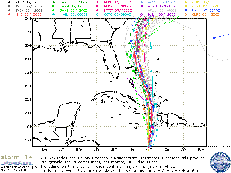
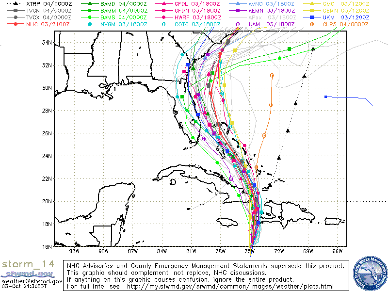
As an example of how much the models can swing in the 3-5 day range, in just two model cycles (12 hours total), I present Matthew, 3 years ago:
http://flhurricane.com/images/2016/stor ... 3-1222.gif
http://flhurricane.com/images/2016/stor ... 3-2144.gif
And we all know how that played out.
2 likes
Frances 04 / Jeanne 04 / Katrina 05 / Wilma 05 / Fay 08 / Debby 12 / Andrea 13 / Colin 16 / Hermine 16 / Matthew 16 / Irma 17


Re: ATL: DORIAN - Models
SouthDadeFish wrote:Aric Dunn wrote:The euro still cant seem to get the initial conditions correct...
What is it doing wrong?
Said it's initialized 20 miles off or something. I'm assuming they factored in that 12z is 8am and not now.
And Evil J, I know and agree. I don't agree this time. There's only so far it can get in 120 hours.
EC at 48 hours roughly 26.5N. It's probably going to bend it WSW again or it's coming in a bit farther north than last run
Last edited by Steve on Fri Aug 30, 2019 1:03 pm, edited 1 time in total.
0 likes
-
SouthDadeFish
- Professional-Met
- Posts: 2835
- Joined: Thu Sep 23, 2010 2:54 pm
- Location: Miami, FL
- Contact:
-
Aric Dunn
- Category 5
- Posts: 21238
- Age: 43
- Joined: Sun Sep 19, 2004 9:58 pm
- Location: Ready for the Chase.
- Contact:
Re: ATL: DORIAN - Models
SouthDadeFish wrote:Aric Dunn wrote:The euro still cant seem to get the initial conditions correct...
What is it doing wrong?
First glance.. still has it at 991 mb and im sure like previous runs there is more.
0 likes
Note: If I make a post that is brief. Please refer back to previous posts for the analysis or reasoning. I do not re-write/qoute what my initial post said each time.
If there is nothing before... then just ask
Space & Atmospheric Physicist, Embry-Riddle Aeronautical University,
I believe the sky is falling...
If there is nothing before... then just ask
Space & Atmospheric Physicist, Embry-Riddle Aeronautical University,
I believe the sky is falling...
-
beachman80
Re: ATL: DORIAN - Models
Agree that model swings can happen...
but....
I do think the models don't feel that the High in the Atlantic can stay there forever. Eventually it's gotta move or weaken or even break down. And I think the slower this moves around the Bahamas region, the better the chance this turns north perhaps before it gets to Florida. The worst thing that can happen for Florida right now is if this thing picks up speed. Then the GOM and Gulf coast comes into play. But the slower it moves from to the Bahamas, the more east thing track will be. I don't think the models think that High can stay in place for another 96+ hours.
0 likes
-
Hypercane_Kyle

- Category 5
- Posts: 3465
- Joined: Sat Mar 07, 2015 7:58 pm
- Location: Cape Canaveral, FL
Re: ATL: DORIAN - Models
SouthDadeFish wrote:Today's 12Z EC is much faster than yesterday's 12Z EC.
What implications do you think this would have?
0 likes
My posts are my own personal opinion, defer to the National Hurricane Center (NHC) and other NOAA products for decision making during hurricane season.

Re: ATL: DORIAN - Models
chris_fit wrote:Pretty much identical to the 00z for now
Faster westward movement is going to be pivotal on whether it'll scrape the coastline or plow through central FL. This run seems to be a tad more west
0 likes
-
AutoPenalti
- Category 5
- Posts: 4091
- Age: 29
- Joined: Mon Aug 17, 2015 4:16 pm
- Location: Ft. Lauderdale, Florida
Re: ATL: DORIAN - Models
Aric Dunn wrote:SouthDadeFish wrote:Aric Dunn wrote:The euro still cant seem to get the initial conditions correct...
What is it doing wrong?
First glance.. still has it at 991 mb and im sure like previous runs there is more.
I believe you were looking at the 500mb chart.
1 likes
The posts in this forum are NOT official forecasts and should not be used as such. They are just the opinion of the poster and may or may not be backed by sound meteorological data. They are NOT endorsed by any professional institution or STORM2K. For official information, please refer to products from the NHC and NWS.
Model Runs Cheat Sheet:
GFS (5:30 AM/PM, 11:30 AM/PM)
HWRF, GFDL, UKMET, NAVGEM (6:30-8:00 AM/PM, 12:30-2:00 AM/PM)
ECMWF (1:45 AM/PM)
TCVN is a weighted averaged
Re: ATL: DORIAN - Models
sounds like we need to take a census to make sense of this consensus.
5 likes
-
AutoPenalti
- Category 5
- Posts: 4091
- Age: 29
- Joined: Mon Aug 17, 2015 4:16 pm
- Location: Ft. Lauderdale, Florida
Re: ATL: DORIAN - Models
Bermuda ridge seems weaker... hmm...
2 likes
The posts in this forum are NOT official forecasts and should not be used as such. They are just the opinion of the poster and may or may not be backed by sound meteorological data. They are NOT endorsed by any professional institution or STORM2K. For official information, please refer to products from the NHC and NWS.
Model Runs Cheat Sheet:
GFS (5:30 AM/PM, 11:30 AM/PM)
HWRF, GFDL, UKMET, NAVGEM (6:30-8:00 AM/PM, 12:30-2:00 AM/PM)
ECMWF (1:45 AM/PM)
TCVN is a weighted averaged

Re: ATL: DORIAN - Models
SouthDadeFish wrote:Today's 12Z EC is much faster than yesterday's 12Z EC.
Yeah yesterdays 12z ECM was crazy slow, like 36hrs slower than even the next slower run! This looks alot more reasonable to me though.
Anyway about to truck into the Bahamas now at 48hrs out.
0 likes
Personal Forecast Disclaimer:
The posts in this forum are NOT official forecast and should not be used as such. They are just the opinion of the poster and may or may not be backed by sound meteorological data. They are NOT endorsed by any professional institution or storm2k.org. For official information, please refer to the NHC and NWS products
The posts in this forum are NOT official forecast and should not be used as such. They are just the opinion of the poster and may or may not be backed by sound meteorological data. They are NOT endorsed by any professional institution or storm2k.org. For official information, please refer to the NHC and NWS products
-
Kosmo Kitty

- Tropical Wave

- Posts: 9
- Joined: Wed Sep 20, 2017 4:32 pm
- Location: South Florida
Re: ATL: DORIAN - Models
I have a chance to move my flight out of FLL Sunday afternoon to Sunday early morning out of MIA, at a huge cost of $800. Still I would take it if Sunday morning really makes a big difference.
Any advice?
Any advice?
Last edited by Kosmo Kitty on Fri Aug 30, 2019 1:07 pm, edited 1 time in total.
0 likes
-
Aric Dunn
- Category 5
- Posts: 21238
- Age: 43
- Joined: Sun Sep 19, 2004 9:58 pm
- Location: Ready for the Chase.
- Contact:
Re: ATL: DORIAN - Models
AutoPenalti wrote:Aric Dunn wrote:SouthDadeFish wrote:
What is it doing wrong?
First glance.. still has it at 991 mb and im sure like previous runs there is more.
I believe you were looking at the 500mb chart.
No 850mb.. and surface starts at 988mb so yeah.
0 likes
Note: If I make a post that is brief. Please refer back to previous posts for the analysis or reasoning. I do not re-write/qoute what my initial post said each time.
If there is nothing before... then just ask
Space & Atmospheric Physicist, Embry-Riddle Aeronautical University,
I believe the sky is falling...
If there is nothing before... then just ask
Space & Atmospheric Physicist, Embry-Riddle Aeronautical University,
I believe the sky is falling...
-
petit_bois
- Tropical Storm
- Posts: 227
- Joined: Tue Jun 22, 2010 12:04 pm
- Location: Petit Bois Island Mississippi
Re: ATL: DORIAN - Models
Evil Jeremy wrote:Steve wrote:petit_bois wrote:
yep... that's what they were saying in 2005 too. I remember my local radio station weather guy giving our area the all clear as late as Friday afternoon. total Chaos came on Monday.
Storm2k had it though. I caught the early cycle 18z guidance that Friday afternoon, and it was on. Next move was the NHC moving the landfall point 200 miles. That's seriously not going to happen this time. I'd bet any amount of money it doesn't cross 85 in the next 5 days. Most models don't get into the Gulf at all (ICON and possibly HWRF if it ran longer, but still unlikely). EC is the next chance.
As an example of how much the models can swing in the 3-5 day range, in just two model cycles (12 hours total), I present Matthew, 3 years ago:
http://flhurricane.com/images/2016/stor ... 3-1222.gif
http://flhurricane.com/images/2016/stor ... 3-2144.gif
And we all know how that played out.
get outta here... fake news... you're looking at model runs from Oct 2013... I was here too... Shock and amazement that Friday night-Saturday here when it refused to turn north... Like I said... $2.5mill is the bet
0 likes
Resident of the Atlantic Basin's Major Hurricane Hit Capital!
Camille (200+winds), Frederic, Goerges, Katrina... and many many more.
Disclaimer: I'm likely the smartest guy here... but I have no idea where a tropical cyclone will go. I suggest you take my opinion as a grain of salt. I suggest you look to the National Hurricane Center for accurate info.
Camille (200+winds), Frederic, Goerges, Katrina... and many many more.
Disclaimer: I'm likely the smartest guy here... but I have no idea where a tropical cyclone will go. I suggest you take my opinion as a grain of salt. I suggest you look to the National Hurricane Center for accurate info.
Who is online
Users browsing this forum: No registered users and 18 guests