
I’ve been on here lurking in the shadows for a few years now and I’ve noticed a trend over those years with the models. During the daytime runs they typically shift to the east and in the overnight or evening runs things tend to shift back to the west. Why is this? Everyone calls this the windshield wiper effect but if you look at when this effect is happening it regularly falls into daytime/west. nighttime/west
Thank you in advance.
ATL: DORIAN - Models
Moderator: S2k Moderators
Re: ATL: DORIAN - Models
3 likes

Re: ATL: DORIAN - Models
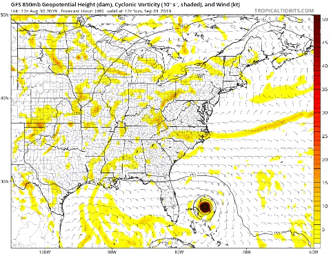
I see what is going with the 12z Euro compared to last night's run, besides now showing a weaker ridge to its north at 48-72 hrs, it delays the short wave trough coming across the northern US into the great lakes, which now shows it to be stronger. So the Western US ridge will not extend eastward towards the MS river Valley when Dorian approaches FL which will create a stronger weakness to the north of Dorian for it to take advantage of. It will all depend on the timing of that shortwave trough forecasted to come across the northern US.
GFS shows the weakness to be weaker and more ridging than what the Euro shows at 96 & 120 hr forecast north of Dorian.
GFS shows the weakness to be weaker and more ridging than what the Euro shows at 96 & 120 hr forecast north of Dorian.
Last edited by NDG on Fri Aug 30, 2019 2:17 pm, edited 3 times in total.
4 likes
Re: ATL: DORIAN - Models
catskillfire51 wrote:Does the fact the euro initializes Dorian at 991, it doesn’t get to 967mb till it gets to Florida but it’s currently at 967 or even lower when recon gets back, but will that have big impacts on track in the future?
Not really, it's a known limitation in the ECMWF:
HRES errors in central pressure are erratic but have a relatively small average bias, meanwhile the ENS Control run is generally not deep enough by around 15hPa.
(ref: https://confluence.ecmwf.int/display/FU ... e+products)
4 likes
-
AutoPenalti
- Category 5

- Posts: 4091
- Age: 29
- Joined: Mon Aug 17, 2015 4:16 pm
- Location: Ft. Lauderdale, Florida
Re: ATL: DORIAN - Models
These runs are honestly making my head hurt.
10 likes
The posts in this forum are NOT official forecasts and should not be used as such. They are just the opinion of the poster and may or may not be backed by sound meteorological data. They are NOT endorsed by any professional institution or STORM2K. For official information, please refer to products from the NHC and NWS.
Model Runs Cheat Sheet:
GFS (5:30 AM/PM, 11:30 AM/PM)
HWRF, GFDL, UKMET, NAVGEM (6:30-8:00 AM/PM, 12:30-2:00 AM/PM)
ECMWF (1:45 AM/PM)
TCVN is a weighted averaged
Re: ATL: DORIAN - Models
AutoPenalti wrote:These runs are honestly making my head hurt.
I'm about to start drinking, I'm about to give up, we still got a good 72 hrs of model watching lol.
20 likes

Re: ATL: DORIAN - Models
One model run saying this will miss Florida is not enough to start sounding the all clear. Look at where the models said Irma would be 60 hours out.
It is a bit irresponsible for any 'pro' met to tell the public that Florida will likely get spared this early out.
If that trend continues through tomorrow morning then we can start feeling a little better.
It is a bit irresponsible for any 'pro' met to tell the public that Florida will likely get spared this early out.
If that trend continues through tomorrow morning then we can start feeling a little better.
5 likes
-
hurricaneCW
- Category 5
- Posts: 1799
- Joined: Wed Mar 03, 2010 6:20 am
- Location: Toms River, NJ
Re: ATL: DORIAN - Models
The NHC doesn't do model hugging. They may shift slightly but the consensus is still on a FL landfall.
Don't get caught up in one model run.
Don't get caught up in one model run.
4 likes
Re: ATL: DORIAN - Models
First post, have been reading for 15+ years. I had an account but forgot credentials so created a new one. If a mod can link me to my old account via email I’d appreciate.
This link is probably a staple for most but if anyone isn’t aware, the magenta line has been very accurate in predicting the hurricane’s eventual landfall.
https://www.sfwmd.gov/weather-radar/cur ... conditions
It’s replotted at every NHC update so it’s obviously using their modeling.
**update - the south florida wmd website seems to be down atm and it's one of my favorite weather radars...please fix it cheers
0 likes
I'm a hurricane magnet.
Frances, Jeanne, Wilma, Matthew, and Irma
Frances, Jeanne, Wilma, Matthew, and Irma

Re: ATL: DORIAN - Models
Salute,
thanks, psyclone
Unless you have been thru numerous storms and near misses, you must "interpret" the models and discard a significant portion of the national media.
The local weather folks and experienced storm survivors have much better results predicting last day or two track within 30 - 40 miles or so.
that being said, if you have not been there, LEAVE and look back at a peaceful beach or Armageddon as we saw lasr Oct with Mexico Beach. And know what? Extremely low casualties because those folks got out early, many for the first time.
This storm will be a bear when it hits land, but storm surge nothing like Katrina, Camille, Audrey, 1947 storm, Betsy, Ike, Rita, Hugo, Ivan, and on The sea floor and coast elevation on the Gulf coast is much different than on the Atlantic except for the low country on South Carolina and southern Georgia.
************
Models now are 200% better than 40 years ago, but you still have to interpret to make good decisions about leaving. And you must be willing to cook and drink as we did 200 years ago for days or even weeks if you ride it out and live.
Gums sends....
3 likes
-
Hypercane_Kyle

- Category 5
- Posts: 3465
- Joined: Sat Mar 07, 2015 7:58 pm
- Location: Cape Canaveral, FL
Re: ATL: DORIAN - Models
NDG wrote:AutoPenalti wrote:These runs are honestly making my head hurt.
I'm about to start drinking, I'm about to give up, we still got a good 72 hrs of model watching lol.
Heck, I remember when this storm maybe had 72 hours to live before it was expected to die out in the MDR.
5 likes
My posts are my own personal opinion, defer to the National Hurricane Center (NHC) and other NOAA products for decision making during hurricane season.


Re: ATL: DORIAN - Models

This was Irma's model plot 4 days out and we all know how that went. Doesn't take much to shift one way or another, still need to be alert
9 likes
-
otowntiger
- Category 5
- Posts: 1932
- Joined: Tue Aug 31, 2004 7:06 pm
Re: ATL: DORIAN - Models
chris_fit wrote:https://i.imgur.com/d7n8D6n.png
I’m really starting to agree that this will be Matthew 2. Still obviously not good for some on the coast but certainly a lot better than it could be. I realize it’s still early but wow- big big change.
0 likes
Re: ATL: DORIAN - Models
12Z Euro ensemble: Many more members miss FL to the east than hit FL...maybe 2/3 of them.
1 likes
Personal Forecast Disclaimer:
The posts in this forum are NOT official forecasts and should not be used as such. They are just the opinion of the poster and may or may not be backed by sound meteorological data. They are NOT endorsed by any professional institution or storm2k.org. For official information, please refer to the NHC and NWS products.
The posts in this forum are NOT official forecasts and should not be used as such. They are just the opinion of the poster and may or may not be backed by sound meteorological data. They are NOT endorsed by any professional institution or storm2k.org. For official information, please refer to the NHC and NWS products.
-
hohnywx
- Category 2

- Posts: 511
- Age: 35
- Joined: Sun Jul 19, 2009 8:34 pm
- Location: Hastings-on-Hudson, NY
Re: ATL: DORIAN - Models
jfk08c wrote:https://i.imgur.com/VU0O7RU.png
This was Irma's model plot 4 days out and we all know how that went. Doesn't take much to shift one way or another, still need to be alert
That looks like a lot more "consensus" than we have now. Thanks for the look back in history.
2 likes
-
HurricaneFrances04
- Category 2
- Posts: 597
- Joined: Mon Jun 25, 2012 8:09 am
- Location: Fort Lauderdale, Florida

Re: ATL: DORIAN - Models
LarryWx wrote:12Z Euro ensemble: Many more members miss FL to the east than hit FL...maybe 2/3 of them.
The beginnings of a trend. Stay safe for those in it’s path.
2 likes
Re: ATL: DORIAN - Models
Looking at the visible and the Dvorak, it may already be near a Cat 4 already. Unfortunately there is no recon out there to confirm how much stronger he is since this morning.
1 likes
-
toad strangler

- S2K Supporter

- Posts: 4546
- Joined: Sun Jul 28, 2013 3:09 pm
- Location: Earth
- Contact:
-
SEASON_CANCELED

- Category 3

- Posts: 887
- Joined: Mon Jul 06, 2009 5:17 am
- Location: 8 Bit Charlie Sheen
Re: ATL: DORIAN - Models
jfk08c wrote:https://i.imgur.com/VU0O7RU.png
This was Irma's model plot 4 days out and we all know how that went. Doesn't take much to shift one way or another, still need to be alert
Thanks for this. I was about to post this, all those who worship at the alter of model accuracy never bring up the old forecasts
4 likes
i am a big stupid ugly moron with an ugly face and a big butt and my butt stinks and i like to kiss my own butt
Who is online
Users browsing this forum: No registered users and 22 guests