ATL: DORIAN - Post-Tropical - Discussion
Moderator: S2k Moderators
Re: ATL: DORIAN - Hurricane - Discussion
Is there word on whether Dorian has started the turn west. John Morales in NBC6 just said it’s starting the turn on a brief update
0 likes
-
Hypercane_Kyle

- Category 5

- Posts: 3465
- Joined: Sat Mar 07, 2015 7:58 pm
- Location: Cape Canaveral, FL
Re: ATL: DORIAN - Hurricane - Discussion
AF307 has just taken off on an unassigned mission to Dorian. Unlikely it'll make it to Dorian before 5pm though.
Last edited by Hypercane_Kyle on Fri Aug 30, 2019 2:58 pm, edited 1 time in total.
1 likes
My posts are my own personal opinion, defer to the National Hurricane Center (NHC) and other NOAA products for decision making during hurricane season.
-
Mouton
- S2K Supporter

- Posts: 222
- Age: 80
- Joined: Sat Jul 30, 2011 8:13 am
- Location: Amelia Island Florida
Re: ATL: DORIAN - Hurricane - Discussion
Posted this on the wrong board:
The coming NHC advisory will be interesting...last real one before public signs off. I would estimate they will be conservative and probably nudge their move to the right maybe 75 miles or so due to the movement in the models and if they get info the ridge is not building as fast or as much as expected. At the 11 edt advisory, they put in a sharp move to the right after landfall so they may not want to overdo it. For a final path, Mathew is a potential but just a 50 mile west of its path would be far more destructive compared to the actual damage that occurred. FWIW, our Fernandina barometer has been dropping the past few hours which would belie a notion the ridge is building west. Lastly, above Vero, the in closein water temps, west side of the GS, are unseasonably cool.
3 days ago, based on a WAG, I drew a line at 80w as west most advance. I'd love to be correct. Models with a good record show cat 4 intensity with a few at the mid point. NO 5s.
1 likes
-
Aric Dunn
- Category 5
- Posts: 21238
- Age: 43
- Joined: Sun Sep 19, 2004 9:58 pm
- Location: Ready for the Chase.
- Contact:
Re: ATL: DORIAN - Hurricane - Discussion
caneseddy wrote:Is there word on whether Dorian has started the turn west. John Morales in NBC6 just said it’s starting the turn on a brief update
looking at sat. it sure looks just north of west..
1 likes
Note: If I make a post that is brief. Please refer back to previous posts for the analysis or reasoning. I do not re-write/qoute what my initial post said each time.
If there is nothing before... then just ask
Space & Atmospheric Physicist, Embry-Riddle Aeronautical University,
I believe the sky is falling...
If there is nothing before... then just ask
Space & Atmospheric Physicist, Embry-Riddle Aeronautical University,
I believe the sky is falling...
-
Blown Away

- S2K Supporter
- Posts: 10253
- Joined: Wed May 26, 2004 6:17 am
Re: ATL: DORIAN - Hurricane - Discussion
Dorian has been on the right side of the error cone most of his life... It was supposed to hit Hispaniola a few days out and missed PR to the east...
1 likes
Hurricane Eye Experience: David 79, Irene 99, Frances 04, Jeanne 04, Wilma 05… Hurricane Brush Experience: Andrew 92, Erin 95, Floyd 99, Matthew 16, Irma 17, Ian 22, Nicole 22…
Re: ATL: DORIAN - Hurricane - Discussion
[quote="aperson"]Eye temps are shooting up. Currently a real warm spot in the eye that naively looks to me like a mesovort mixing around.
{/quote]
Just for fun
"Tropical cyclones can become annular as a result of eyewall mesovortices mixing the strong winds found in the eyewalls of storms with the weak winds of the eye, which helps to expand the eye. In addition, this process helps to make the equivalent potential temperature (often referred to as theta-e or {\displaystyle \theta _{e}} \theta _{e}) within the eye relatively uniform. "
2 likes

Re: ATL: DORIAN - Hurricane - Discussion
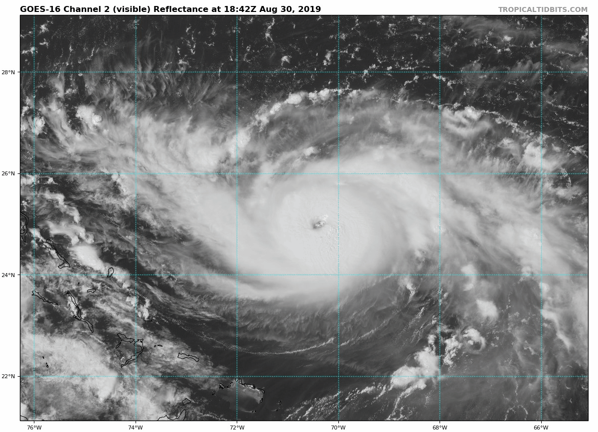
Holy cow! - look at that convection around the eye.
10 likes
-
Blown Away
- S2K Supporter
- Posts: 10253
- Joined: Wed May 26, 2004 6:17 am
Re: ATL: DORIAN - Hurricane - Discussion
Hypercane_Kyle wrote:AF307 has just taken off on an unassigned mission to Dorian. Unlikely it'll make it to Dorian before 5pm though.
Dorian is close enough now and the NHC will agressively sample the high pressure out in front and I expect in the next few NHC Disco's a conclusion the HP was stronger or weaker than expected...
2 likes
Hurricane Eye Experience: David 79, Irene 99, Frances 04, Jeanne 04, Wilma 05… Hurricane Brush Experience: Andrew 92, Erin 95, Floyd 99, Matthew 16, Irma 17, Ian 22, Nicole 22…

Re: ATL: DORIAN - Hurricane - Discussion
6 likes
Very useful information on the Dvorak Technique --
https://severe.worldweather.wmo.int/TCF ... kBeven.pdf
https://severe.worldweather.wmo.int/TCF ... kBeven.pdf
-
PandaCitrus
- Category 1

- Posts: 424
- Joined: Mon Sep 04, 2017 2:44 pm
Re: ATL: DORIAN - Hurricane - Discussion
Is this north of due west turn earlier than the models are saying? What does this mean for the eventual track a south shift and stall near Miami/Ft. Lauderdale instead of Jupiter?
0 likes
-
rickybobby
- Tropical Storm

- Posts: 174
- Joined: Fri Sep 18, 2015 11:11 am
- Location: Central Florida
Re: ATL: DORIAN - Hurricane - Discussion
Wesh 2’s Tony said he expects the cone to move to the east by maybe 50 miles at the 5pm update. There’s hope the it will recurve and not hit any land and that chance is increasing.
Last edited by rickybobby on Fri Aug 30, 2019 3:11 pm, edited 1 time in total.
0 likes
Re: ATL: DORIAN - Hurricane - Discussion
Looks to me it have pretty much stalled for an hour, or at least not moving much
Last edited by Airboy on Fri Aug 30, 2019 3:11 pm, edited 1 time in total.
0 likes
Personal Forecast Disclaimer:
The posts in this forum are NOT official forecast and should not be used as such. They are just the opinion of the poster and may or may not be backed by sound meteorological data. They are NOT endorsed by any professional institution or storm2k.org. For official information, please refer to the NHC and NWS products.
The posts in this forum are NOT official forecast and should not be used as such. They are just the opinion of the poster and may or may not be backed by sound meteorological data. They are NOT endorsed by any professional institution or storm2k.org. For official information, please refer to the NHC and NWS products.
-
AxaltaRacing24
- Category 5
- Posts: 1774
- Age: 25
- Joined: Wed Jul 27, 2016 11:14 am
- Location: Jupiter, FL
Re: ATL: DORIAN - Hurricane - Discussion
Airboy wrote:Looks to me it have pretty much stalled for on hour, or at least not moving much
A sign that the turn is imminent.
2 likes
-
Kingarabian

- S2K Supporter
- Posts: 16367
- Joined: Sat Aug 08, 2009 3:06 am
- Location: Honolulu, Hawaii
Re: ATL: DORIAN - Hurricane - Discussion
b0tzy29 wrote:Holy cow! - look at that convection around the eye.
[url]https://media.giphy.com/media/LPYsmAvGq7wjMS1DZO/source.gif[url]
That convection around the eye is still a little too warm thus its holding up Dvorak estimates from going higher.

1 likes
RIP Kobe Bryant
Re: ATL: DORIAN - Hurricane - Discussion
AxaltaRacing24 wrote:Airboy wrote:Looks to me it have pretty much stalled for on hour, or at least not moving much
A sign that the turn is imminent.
On a NW to WNW/West turn? Doubtful, it might had hit a weak steering pocket.
0 likes
-
Aric Dunn
- Category 5
- Posts: 21238
- Age: 43
- Joined: Sun Sep 19, 2004 9:58 pm
- Location: Ready for the Chase.
- Contact:
Re: ATL: DORIAN - Hurricane - Discussion
Looks like another ERC is starting.. some evidence of inner convection firing and an outer ring of convection.. hard to say but sure looks like it ..

3 likes
Note: If I make a post that is brief. Please refer back to previous posts for the analysis or reasoning. I do not re-write/qoute what my initial post said each time.
If there is nothing before... then just ask
Space & Atmospheric Physicist, Embry-Riddle Aeronautical University,
I believe the sky is falling...
If there is nothing before... then just ask
Space & Atmospheric Physicist, Embry-Riddle Aeronautical University,
I believe the sky is falling...
-
PandaCitrus
- Category 1
- Posts: 424
- Joined: Mon Sep 04, 2017 2:44 pm
Re: ATL: DORIAN - Hurricane - Discussion
They mean an earlier western turn. Not a turn to the north. That won't happen near the Bahamas or over Florida if it happens.
2 likes
Re: ATL: DORIAN - Hurricane - Discussion
If the storm turns more due west (or even south of west) sooner watch for the Euro wiper back left on the 0z.
1 likes
Re: ATL: DORIAN - Hurricane - Discussion
rickybobby wrote:AxaltaRacing24 wrote:Airboy wrote:Looks to me it have pretty much stalled for on hour, or at least not moving much
A sign that the turn is imminent.
Looks like Florida won’t get hit
Unless you're a met/pro forecaster, don't make statements like this. They can get people's hopes up for no reason. You aren't giving space to the idea that this is a minor wobble in the path of a hurricane that may mean nothing.
Official forecast still has Florida taking a direct hit. Until that chances, we need to keep the -removed- to a minimum.
7 likes

Re: ATL: DORIAN - Hurricane - Discussion
ozonepete wrote:rickybobby wrote:AxaltaRacing24 wrote:A sign that the turn is imminent.
Looks like Florida won’t get hit
Please don't do that without saying it's an amateur's opinion. A lot of people on here might take you seriously and of course you don't want that responsibility, right?
I make a lot of predictions (half of which end up wrong
On that note, the Euro seems to be the outlier at the moment so I wouldn't base anything off of one run. While I'm leaning towards Matthew track myself, everybody from Miami to the Outer Banks needs to prepare for a direct hit from a major.
Last edited by Hammy on Fri Aug 30, 2019 3:17 pm, edited 1 time in total.
2 likes
The above post is not official and should not be used as such. It is the opinion of the poster and may or may not be backed by sound meteorological data. It is not endorsed by any professional institution or storm2k.org. For official information, please refer to the NHC and NWS products.
Who is online
Users browsing this forum: No registered users and 22 guests