
MCO/Orlando International Airport is taking this seriously .
http://www.fox35orlando.com/home/orland ... 1nbMFIwheM
ATL: DORIAN - Post-Tropical - Discussion
Moderator: S2k Moderators

Re: ATL: DORIAN - Hurricane - Discussion
hmmm the NHC did shift the landfall to basically go right up the coast of Florida
Last edited by CronkPSU on Fri Aug 30, 2019 3:55 pm, edited 2 times in total.
0 likes
Just like Jon Snow..."I know nothing" except what I know, and most of what I know is gathered by the fine people of the NHC

Re: ATL: DORIAN - Hurricane - Discussion
HurricaneFrances04 wrote:Blown Away wrote:Dorian looks a little R of the track now... Starting to feel optimistic...
The 2 pm position was dead on from the 5 am forecast this morning:
INIT 30/0900Z 23.8N 69.1W 90 KT 105 MPH
12H 30/1800Z 24.8N 70.3W 100 KT 115 MPH
2:00 PM AST Fri Aug 30
Location: 24.8°N 70.3°W
Quite a difference in forecast skill from a few years or so ago when we'd see the storm going off the forecast track just an hour or two after the advisory.
0 likes
The above post is not official and should not be used as such. It is the opinion of the poster and may or may not be backed by sound meteorological data. It is not endorsed by any professional institution or storm2k.org. For official information, please refer to the NHC and NWS products.
-
ozonepete
- Professional-Met

- Posts: 4743
- Joined: Mon Sep 07, 2009 3:23 pm
- Location: From Ozone Park, NYC / Now in Brooklyn, NY
Re: ATL: DORIAN - Hurricane - Discussion
fci wrote:ozonepete wrote:rickybobby wrote:Wesh 2’s Tony said he expects the cone to move to the east by maybe 50 miles at the 5pm update. There’s hope the it will recurve and not hit any land and that chance is increasing.
It's almost certainly going to hit land. Just not clear where but somewhere from central FL to Hatteras.
I'm not sure you can really say that. While it very well might hit land, the models are trending towards a solution that it could stay offshore.
The models are trending toward a solution that it could stay offshore of Florida, not offshore of the entire southeast coast.
I said "almost certainly" not certainly. The great majority of tracks includng ensemble members show it hitting land somewhere before going out to sea. this is because, if you look at the steering currents from now until 10 days out, the least plausible path is out to sea without ever hitting land. That's just what the models said. So the models support almost certainly. Ok?
8 likes

Re: ATL: DORIAN - Hurricane - Discussion
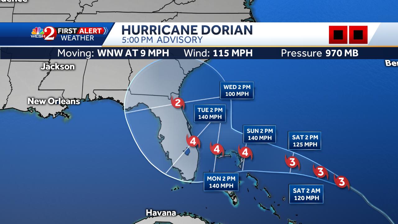
CronkPSU wrote:hmmm the NHC did shift the landfall to basically go right up the coast of Florida
https://pbs.twimg.com/media/EDPv7oiWkAEskuR.jpg:large
Greeeeat. Good thing we’re putting our boards up I guess
0 likes
-
craptacular
- Category 2

- Posts: 581
- Joined: Wed Aug 02, 2006 9:17 pm
- Location: The Mad City, WI
Re: ATL: DORIAN - Hurricane - Discussion
Aric Dunn wrote:we need more g4 flights.. not sure why there is not one today..
Am curious as well, as they were scheduled for every 12 hours. Anyway, I checked FlightAware, and Gonzo (NOAA 49, G-IV, tail number N49RF) made a one-hour flight from Lakeland to Savannah, GA very early this morning ... nothing since then. The TCPOD issued yesterday mentioned the G-IV flights for tomorrow would be taking off from Lakeland (KLAL). However, the TCPOD issued today still showed scheduled flights for tomorrow, and then mentioned Sunday's flights would take off from New Orleans. I wonder if Savannah has some specialized maintenance capability that they can't do at Lakeland. I'd think there has to be some big problem for them not to be flying a mission on this critical day.
0 likes
-
SFLcane

- S2K Supporter

- Posts: 10281
- Age: 48
- Joined: Sat Jun 05, 2010 1:44 pm
- Location: Lake Worth Florida
Re: ATL: DORIAN - Hurricane - Discussion
So the turn has begun this will be key to watch during the next couple of days.
0 likes
Re: ATL: DORIAN - Hurricane - Discussion
Cee235 wrote:CronkPSU wrote:hmmm the NHC did shift the landfall to basically go right up the coast of Florida
https://pbs.twimg.com/media/EDPv7oiWkAEskuR.jpg:large
Greeeeat. Good thing we’re putting our boards up I guess
Is it me or has landfall just been sitting consistently at 96h for days now

3 likes
The above post is not official and should not be used as such. It is the opinion of the poster and may or may not be backed by sound meteorological data. It is not endorsed by any professional institution or storm2k.org. For official information, please refer to the NHC and NWS products.

Re: ATL: DORIAN - Hurricane - Discussion
AxaltaRacing24 wrote:fci wrote:ozonepete wrote:
It's almost certainly going to hit land. Just not clear where but somewhere from central FL to Hatteras.
I'm not sure you can really say that. While it very well might hit land, the models are trending towards a solution that it could stay offshore.
That doesn’t mean that they won’t trend back. Dorian really has no real escape route. If it doesn’t make landfall, it’d be very very close.
For sure, they could.
But, the trend here is towards a "climatological solution" so the possibility truly exists that it will not make landfall.
Not true that there is no real escape route as it relates to hitting the CONUS.
Northern Bahamas are another story.
0 likes
Personal Forecast Disclaimer:
My posts are just my opinion and are most likely not backed by sound meteorological data. They are NOT endorsed by any professional institution or storm2k.org. For official information, please refer to the NHC and NWS products.
Bottom line is that I am just expressing my opinion!!!
My posts are just my opinion and are most likely not backed by sound meteorological data. They are NOT endorsed by any professional institution or storm2k.org. For official information, please refer to the NHC and NWS products.
Bottom line is that I am just expressing my opinion!!!

Re: ATL: DORIAN - Hurricane - Discussion
I don't know what the rules are to trigger an evacuation in FL/GA/SC/NC, but given how the latest models show it either riding the coast just offshore or just onshore... how many millions of people along the coast would be evacuated over the next 5 days? Even if it does stay offshore, if there's a Cat-4 20 miles off shore that could wobble on-shore, isn't the governor forced to pull the trigger on mandatory evacuations?
1 likes
Re: ATL: DORIAN - Hurricane - Discussion
so now that we "all" and the NHC move the forecast east based off the last computer models, it is about time for GFS to do something crazy, it is Friday of a three day weekend Happy Hour
2 likes
Just like Jon Snow..."I know nothing" except what I know, and most of what I know is gathered by the fine people of the NHC
Re: ATL: DORIAN - Hurricane - Discussion
fci wrote:AxaltaRacing24 wrote:fci wrote:
I'm not sure you can really say that. While it very well might hit land, the models are trending towards a solution that it could stay offshore.
That doesn’t mean that they won’t trend back. Dorian really has no real escape route. If it doesn’t make landfall, it’d be very very close.
For sure, they could.
But, the trend here is towards a "climatological solution" so the possibility truly exists that it will not make landfall.
Not true that there is no real escape route as it relates to hitting the CONUS.
Northern Bahamas are another story.
Climatological "solutions" have no place in a discussion about the path of one hurricane. There's no data to support your hypothesis.
Last edited by CryHavoc on Fri Aug 30, 2019 4:03 pm, edited 1 time in total.
1 likes

Re: ATL: DORIAN - Hurricane - Discussion
I agree with Hammy 1000%. This isn’t kindergarten. It’s one thing to put out patently false information as said user will rightfully get slammed for that. It’s another thing to post as a user and say what you think. Federal law changed several years ago, and this site is not responsible for the content of the users. Hammy and I disagree all the time. That’s a poster who sticks to their ideas. But I read and consider everything she (he?) posts regardless of whether or not I agree.
People who come on here rarely are here for the first time ever. Most have read for a while and maybe never set up an account and often will when they want to contribute or ask something. By all means people shouldn’t post obviously stupid ideas. But it’s been a while since I’ve seen anyone actively trolling S2K. It’s happened in the past for sure. The 180* on that would be to dumb down the forum to the point to where no one would want to participate. It’s a tropical fan site, not a baby sitting service imho. To the Havoc’s point, when there is an active threat, stupidity and bad posts are dealt with much more rigorously as they should be. Tolakram is going to get anybody who says x is y without an explanation. I always appreciate that as it cuts the noise.
As for the discussion, Dorian looks like a Cat 3 now, and it’s already telegraphing by orientation it’s forward direction for the next 36 hours or so at least.
https://www.star.nesdis.noaa.gov/GOES/f ... &length=12
5 likes
Re: ATL: DORIAN - Hurricane - Discussion
fci wrote:But, the trend here is towards a "climatological solution" so the possibility truly exists that it will not make landfall.
Not true that there is no real escape route as it relates to hitting the CONUS.
I'm no expert, but if someone could boil down the track to two factors (yes, I know, that's seriously oversimplifying things), then the models over the past few days were all showing a recurve. And when it made that NE movement was dependent on the arrival of the storm and the steering currents. Seemed like a slower arrival meant a higher chance to push it offshore.
Bunch of the models are showing Dorian ride the coast just on-or-offshore. If those tracks continue, a tiny wobble one way or the other would mean the difference between hurricane force winds from South/Central FL all the way to Cape Hatteras, NC or TS or weaker winds.
I double-checked our hurricane kit. Gassed up cars and gas cans. Sharpened the chainsaw. Can evac if necessary too. Get ahead of the panicky horde.
0 likes
-
MacTavish
Re: ATL: DORIAN - Hurricane - Discussion
CryHavoc wrote:
Climatological "solutions" have no place in a discussion about the path of one hurricane. There's no data to support your hypothesis.
A model solution that aligns with climatology is more belivable than one which doesn't
2 likes
Re: ATL: DORIAN - Hurricane - Discussion
pcolaman wrote:JtSmarts wrote:For all you oldheads on the forum. MikeWatkins, one of the original super-amateurs from the beginnings of s2k is doing videos again.
https://www.youtube.com/watch?v=DkksPw3sAZ8
WOW Mr Mike !! Always enjoyed his theory's and discussions !!!
Thank you SO much for posting this link
Mike is great.
1 likes
Personal Forecast Disclaimer:
My posts are just my opinion and are most likely not backed by sound meteorological data. They are NOT endorsed by any professional institution or storm2k.org. For official information, please refer to the NHC and NWS products.
Bottom line is that I am just expressing my opinion!!!
My posts are just my opinion and are most likely not backed by sound meteorological data. They are NOT endorsed by any professional institution or storm2k.org. For official information, please refer to the NHC and NWS products.
Bottom line is that I am just expressing my opinion!!!
-
northjaxpro

- S2K Supporter
- Posts: 8900
- Joined: Mon Sep 27, 2010 11:21 am
- Location: Jacksonville, FL
Re: RE: Re: ATL: DORIAN - Hurricane - Discussion
jaxfladude wrote:Seriously? Compared to recent hurricanes that have passed and to various degree have impacted Jacksonville Florida how does (at your post's time) Dorian compare? Sorry for delay in replying/asking trying to catch up from when I last read overnight.northjaxpro wrote:Needless to say, Northeast Florida will get serious impacts from extremely dangerous Hurricane Dorian this Labor day Weekend
The latest from the NHC and after seeing the recent guidance consensus, Hurricane conditions are anticipated, major implications with Storm Surge, and Torrential flooding and tornadoes will be HUGE concerns across the entire area.
I will do my best to keep everyone abreasted as to what is happening up here in the Jacksonville metro area, and the conditions. I know the mods and others will probably have threads available about posting on conditions throughout the state.
Godspeed everyone!!! Pray for us all here and all throughout the state of Florida and surrounding areas this Labor Day weekend into next week as well.
Lots have happened since I posted this earlier. We had the 12Z EURO shifted dramatically north and east to the point of even recurving Dorian and missing landfall on the East Florida Coast.Tonight,'ss 00z run packages of the EURO , UKMET and GFS for me will be quite interesting.
For now I want to be very brief as I can before I can fully analyze until after the 00Z packages a bit later.
I want.to now emphasize that the potential is there for Dorian's local impacts to be potentially as strong or even stronger with impacts to Jax and Northeast Florida. Storm Surge and and torrrntiL rains are likely anf we wi see tropical storm force einds for surewiththe approach of Dorian. Should Dorian's ìnner core (eyewall) gets within 40-60 miles of Jax metro, hurricane conditions are expected. Keep in mind anticopated Eyewall Replacement Cycles will serve to expand Dorian's windfield.each time this happens.
NOTE: and EDIT. NHC Advisory currently has Dorian to move through Northeast Florida on Wednesday as a Cat 2 hurricane. So, potentially if this verifies, Dorian could be stronger than Irma was when she impacted Jax area as a Cat 1 .
However, there is now a potential of Dorian missing the Florida East Coast , thanks to today's 12Z EURO. This COULDbe the prayer answered to help.keep this beast of a storm away from us,, IFthis one EURO run can be joined by the other model suite packages. I am rooting hard for continued east shifts tonight. to continue. This would be great news for everyone as this would leand much to the idea that Dorian will recurve and miss us next few days!!.
We will see later tonight!
Last edited by northjaxpro on Fri Aug 30, 2019 4:21 pm, edited 8 times in total.
3 likes
NEVER, EVER SAY NEVER in the tropics and weather in general, and most importantly, with life itself!!
________________________________________________________________________________________
Fay 2008 Beryl 2012 Debby 2012 Colin 2016 Hermine 2016 Julia 2016 Matthew 2016 Irma 2017 Dorian 2019
________________________________________________________________________________________
Fay 2008 Beryl 2012 Debby 2012 Colin 2016 Hermine 2016 Julia 2016 Matthew 2016 Irma 2017 Dorian 2019
-
supercane4867
- Category 5

- Posts: 4966
- Joined: Wed Nov 14, 2012 10:43 am
Re: ATL: DORIAN - Hurricane - Discussion
Very well formed structure. Probably will go through another eyewall replacement by this time tomorrow

4 likes
-
rickybobby
- Tropical Storm

- Posts: 174
- Joined: Fri Sep 18, 2015 11:11 am
- Location: Central Florida
Re: ATL: DORIAN - Hurricane - Discussion
Daytona Beach shores is in a voluntary evacuation.
Daytona AirPort will be closing at midnight on sunday.
Daytona AirPort will be closing at midnight on sunday.
0 likes
-
jaxfladude
- Category 5
- Posts: 1249
- Joined: Wed Aug 24, 2005 9:36 pm
- Location: Jacksonville, Fla
Re: ATL: DORIAN - Hurricane - Discussion
Tv local Jacksonville Florida showing cat two too close to me early next week. Need reassurance that the odds are moving towards Dorian off shore OTS. But that may mean those to the north of me may get hit.
0 likes
Stay safe y'all
Who is online
Users browsing this forum: No registered users and 17 guests