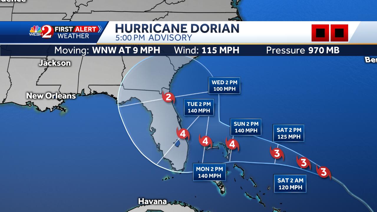
Blown Away wrote:jaxfladude wrote:Tv local Jacksonville Florida showing cat two too close to me early next week. Need reassurance that the odds are moving towards Dorian off shore OTS. But that may mean those to the north of me may get hit.
Yeah, rare event with current track into Jacksonville. I think 24 hours will determine the track either into Florida South/Central coast or begin a recurve towards Carolinas or OTS...
Similar to Mathew were this to happen. BTW, that would be a slightly inland run after an initial impact in Central Fl as a category 4.
I would be mindful of this from NHC as this is not etched in stone either albeit the last two runs have been encouraging for a more eastern shift. Alas, way to early to make such a call given it will turn more to the west from where it is now according to the NHC. This is some info from the NHC who get paid to make the calls:
"The ridge over the western Atlantic appears to be already building
to the north of Dorian and is beginning to force the hurricane on a
more west-northwest track or 300 degrees at 9 kt. The ridge is
forecast to build even more and steer Dorian on a westward track for
the next 3 to 4 days. However, the steering currents will then
weaken, and this should result in a decrease in the hurricane's
forward speed. Given the collapse of the steering currents, the
track forecast by the end of the forecast period is highly
uncertain, and any small deviation in the track could bring the
core of the powerful hurricane well inland over the Florida, keep
it near the coast, or offshore.
The models have not been very
consistent from run to run in terms of the timing of the northward
turn, but there are more models now indicating that the turn could
occur near the east coast of Florida instead of well inland. Given
this latest change, the NHC forecast has been shifted just a little
to the right at this time, but users should be prepared for
additional adjustements to the left or right depending on future
model trends."
The first team is in there now BTW


