ATL: DORIAN - Post-Tropical - Discussion

Moderator: S2k Moderators

Message
Author
User avatar
Steve
S2K Supporter
S2K Supporter
Posts: 9623
Joined: Sat Apr 05, 2003 11:41 pm
Location: Not a state-caster

Re: ATL: DORIAN - Hurricane - Discussion

#3741 Postby Steve » Fri Aug 30, 2019 6:06 pm

GCANE wrote:I have a sick feeling this goes under 900mb before all said and done


I’d take that bet G. Maybe 930’s? Then again, with 947mb, it could get to 920s maybe even next go round.
Last edited by Steve on Fri Aug 30, 2019 6:10 pm, edited 1 time in total.
1 likes   

User avatar
Hammy
Category 5
Category 5
Posts: 5849
Age: 42
Joined: Fri May 25, 2012 5:25 pm
Contact:

Re: ATL: DORIAN - Hurricane - Discussion

#3742 Postby Hammy » Fri Aug 30, 2019 6:07 pm

supercane4867 wrote:946mb


Safe to say rapid intensification underway and this is no longer a 3.
7 likes   
The above post is not official and should not be used as such. It is the opinion of the poster and may or may not be backed by sound meteorological data. It is not endorsed by any professional institution or storm2k.org. For official information, please refer to the NHC and NWS products.

User avatar
EquusStorm
Category 5
Category 5
Posts: 1649
Age: 34
Joined: Thu Nov 07, 2013 1:04 pm
Location: Jasper, AL
Contact:

Re: ATL: DORIAN - Hurricane - Discussion

#3743 Postby EquusStorm » Fri Aug 30, 2019 6:07 pm

946
0 likes   
Colors of lost purpose on the canvas of irrelevance

Not a meteorologist, in fact more of an idiot than anything. You should probably check with the NHC or a local NWS office for official information.

edu2703
Category 1
Category 1
Posts: 349
Joined: Thu Aug 23, 2018 7:15 pm

Re: ATL: DORIAN - Hurricane - Discussion

#3744 Postby edu2703 » Fri Aug 30, 2019 6:07 pm

4 likes   

supercane4867
Category 5
Category 5
Posts: 4966
Joined: Wed Nov 14, 2012 10:43 am

Re: ATL: DORIAN - Hurricane - Discussion

#3745 Postby supercane4867 » Fri Aug 30, 2019 6:07 pm

Weaker side of eyewall 112kts. Definitely a CAT4
6 likes   

User avatar
Highteeld
Category 5
Category 5
Posts: 2139
Age: 41
Joined: Tue Jan 30, 2018 9:10 pm
Location: Chicago

Re: ATL: DORIAN - Hurricane - Discussion

#3746 Postby Highteeld » Fri Aug 30, 2019 6:07 pm

EquusStorm wrote:946

Damn I was close lol
2 likes   
Very useful information on the Dvorak Technique --

https://severe.worldweather.wmo.int/TCF ... kBeven.pdf

Airboy
Category 1
Category 1
Posts: 439
Joined: Wed Jul 27, 2011 10:41 am

Re: ATL: DORIAN - Hurricane - Discussion

#3747 Postby Airboy » Fri Aug 30, 2019 6:07 pm

Extrap. Sfc. Press: 947.3 mb (27.98 inHg)
0 likes   
Personal Forecast Disclaimer:
The posts in this forum are NOT official forecast and should not be used as such. They are just the opinion of the poster and may or may not be backed by sound meteorological data. They are NOT endorsed by any professional institution or storm2k.org. For official information, please refer to the NHC and NWS products.

supercane4867
Category 5
Category 5
Posts: 4966
Joined: Wed Nov 14, 2012 10:43 am

Re: ATL: DORIAN - Hurricane - Discussion

#3748 Postby supercane4867 » Fri Aug 30, 2019 6:08 pm

I’d estimate the current intensity at 125kts
2 likes   

User avatar
Highteeld
Category 5
Category 5
Posts: 2139
Age: 41
Joined: Tue Jan 30, 2018 9:10 pm
Location: Chicago

Re: ATL: DORIAN - Hurricane - Discussion

#3749 Postby Highteeld » Fri Aug 30, 2019 6:09 pm

Highteeld wrote:120 kts/948 mb is my guess based off this IR imagery

https://www.tropicaltidbits.com/sat/images/goes16_ir_goes16-meso2_20190830215857.jpg

called it.
2 likes   
Very useful information on the Dvorak Technique --

https://severe.worldweather.wmo.int/TCF ... kBeven.pdf

User avatar
got ants?
Tropical Storm
Tropical Storm
Posts: 114
Age: 66
Joined: Sat Sep 03, 2011 3:44 am
Location: Hollywood/Ft Laud

Re: ATL: DORIAN - Hurricane - Discussion

#3750 Postby got ants? » Fri Aug 30, 2019 6:09 pm

I hate this typing a post a d the phone rings, anser phone post gone.

Anyhoos, I'm arguing with my brother in Jupiter, because hoe local forecasters are saying the storm is not going to make landfall, and turn north. I go to me Weather Underground app, and jt shows Dorian making landgall, and then a hard turn north out to sea. I can see those watching the adjusted track as if its a prediction of further changes, like he"s saying, it's not even making landfall. WTF!!!

Seriously, look at the WU app it it now shows Dorian making a gard turn north, and leaving land What are they seeing that I am not?
0 likes   
This post is NOT AN OFFICIAL FORECAST and should not be used as such. It is just the opinion of the poster and may or may not be backed by sound meteorological data. It is NOT endorsed by any professional institution including storm2k.org. For Official Information please refer to the NHC and NWS products.

User avatar
PanAmMIA
Tropical Depression
Tropical Depression
Posts: 66
Age: 62
Joined: Mon Aug 30, 2004 11:48 pm
Location: St. Cloud, FL; Islamorada, FL; Tortola, BVI

Re: ATL: DORIAN - Hurricane - Discussion

#3751 Postby PanAmMIA » Fri Aug 30, 2019 6:09 pm

Absolutely agree. We were securing our place in the Keys and decided to take an overnight in Miami. Got caught up in the Zone A evacs in Dade. Took us 14 hours to get back to Orlando area via the Turnpike...and that was calling it quits at YeeHaw Junction and taking the back roads home. Chance favors the prepared mind. Leave early if you can, have an alternate route or two, and be open to any lodging available. With MCO closing Monday morning at 0200 the tourists are stuck here. Book Ocala, Lake City, Tally, Valdosta, etc, now.You can always cancel it later.
sponger wrote:Hard to remember the struggles this storm endured. This may get to 5 easily although a strong 3 or weak 4 at landfall would not surprise me. The panic that a 5 will add to tomorrow's mandatory evacs will be substantial. If you are in SFL take a breath and determine your true risk and try not to get caught up in a panic. The traffic jam tomorrow will be from the GA FL line to Palm Beach so if you need to leave, leave tonight or Sunday at midnight. Sitting in traffic for 20 hours is not going to help your nerves.
1 likes   

User avatar
GCANE
S2K Supporter
S2K Supporter
Posts: 11501
Joined: Mon Oct 22, 2007 8:03 am

Re: ATL: DORIAN - Hurricane - Discussion

#3752 Postby GCANE » Fri Aug 30, 2019 6:09 pm

Helluva a pressure gradient
1 likes   

edu2703
Category 1
Category 1
Posts: 349
Joined: Thu Aug 23, 2018 7:15 pm

Re: ATL: DORIAN - Hurricane - Discussion

#3753 Postby edu2703 » Fri Aug 30, 2019 6:10 pm

112kt unflagged SFMR
0 likes   

supercane4867
Category 5
Category 5
Posts: 4966
Joined: Wed Nov 14, 2012 10:43 am

Re: ATL: DORIAN - Hurricane - Discussion

#3754 Postby supercane4867 » Fri Aug 30, 2019 6:10 pm

25mb drop in 5 hours. That’s some serious rapid intensification
6 likes   

User avatar
StruThiO
Category 3
Category 3
Posts: 821
Age: 25
Joined: Fri Sep 15, 2017 5:51 am
Location: Currently Portland, OR. Raised in Jax, FL.

Re: ATL: DORIAN - Hurricane - Discussion

#3755 Postby StruThiO » Fri Aug 30, 2019 6:11 pm

Image
1 likes   

User avatar
SouthDadeFish
Professional-Met
Professional-Met
Posts: 2835
Joined: Thu Sep 23, 2010 2:54 pm
Location: Miami, FL
Contact:

Re: ATL: DORIAN - Hurricane - Discussion

#3756 Postby SouthDadeFish » Fri Aug 30, 2019 6:11 pm

Yeah this thing is about to explode. Scared to see what it will look like tomorrow morning. This is a disaster for the NW Bahamas.
11 likes   

User avatar
KWT
Category 5
Category 5
Posts: 31415
Joined: Tue Aug 17, 2004 11:02 am
Location: UK!!!

Re: ATL: DORIAN - Hurricane - Discussion

#3757 Postby KWT » Fri Aug 30, 2019 6:11 pm

No surprise pressure has dropped like a stone since that eye has cleared out. Suspect its got a way to go yet as well to be honest. Could well see a 930s reading sooner rather than later.

Also, fully expect to find winds to support something in the range of 115-125kts as well.
2 likes   
Personal Forecast Disclaimer:
The posts in this forum are NOT official forecast and should not be used as such. They are just the opinion of the poster and may or may not be backed by sound meteorological data. They are NOT endorsed by any professional institution or storm2k.org. For official information, please refer to the NHC and NWS products

User avatar
KWT
Category 5
Category 5
Posts: 31415
Joined: Tue Aug 17, 2004 11:02 am
Location: UK!!!

Re: ATL: DORIAN - Hurricane - Discussion

#3758 Postby KWT » Fri Aug 30, 2019 6:14 pm

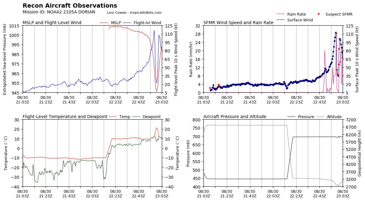
edu2703 wrote:112kt unflagged SFMR


Its definately a cat-4 now, should find 120s in the NE quadrant.

Also worth noting both the GFS and CMC were too far north at 00z in their 12z runs earlier for this point...interesting to note even so close in...
4 likes   
Personal Forecast Disclaimer:
The posts in this forum are NOT official forecast and should not be used as such. They are just the opinion of the poster and may or may not be backed by sound meteorological data. They are NOT endorsed by any professional institution or storm2k.org. For official information, please refer to the NHC and NWS products

wx98
Category 5
Category 5
Posts: 1383
Joined: Sat Aug 25, 2018 9:24 pm

Re: ATL: DORIAN - Hurricane - Discussion

#3759 Postby wx98 » Fri Aug 30, 2019 6:14 pm

Eagerly awaiting the next pass from the east side. I agree with others that it’s prob about 120 kt
0 likes   

supercane4867
Category 5
Category 5
Posts: 4966
Joined: Wed Nov 14, 2012 10:43 am

Re: ATL: DORIAN - Hurricane - Discussion

#3760 Postby supercane4867 » Fri Aug 30, 2019 6:16 pm

Image

Recon measured eye temp over 20C
1 likes   


Return to “2019”

Who is online

Users browsing this forum: No registered users and 1 guest