ATL: DORIAN - Models
Moderator: S2k Moderators

Re: ATL: DORIAN - Models
Yes the steering currents will collapse and just be drifting north due to weak currents off our coast.
0 likes
-
WeatherEmperor
- S2K Supporter

- Posts: 4806
- Age: 42
- Joined: Thu Sep 04, 2003 2:54 pm
- Location: South Florida
Re: ATL: DORIAN - Models
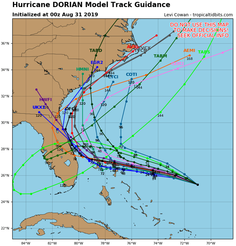
gatorcane wrote:Amazing model swings just 4 days out. Check out the 00Z tracks. Night and day from 24 hours ago. IN fact TVCN recurves with no US landfall:
[imi.postimg.cc/T3PFtpnf/05-L-tracks-00z.png[/img]
I hear you loud and clear Gator. For days it looked like a foregone conclusion FL was going to get hit and the only question being which part of FL. Looking at this map it looks like the models did a complete 180 and turn it away from all land. Totally stunning to say the least
Sent from my iPhone using Tapatalk
4 likes
Re: ATL: DORIAN - Models
supercane4867 wrote:Dorian is no Floyd. The setup is completely different
Matthew?
1 likes
-
gatorcane

- S2K Supporter
- Posts: 23708
- Age: 48
- Joined: Sun Mar 13, 2005 3:54 pm
- Location: Boca Raton, FL
Re: ATL: DORIAN - Models
WeatherEmperor wrote:gatorcane wrote:Amazing model swings just 4 days out. Check out the 00Z tracks. Night and day from 24 hours ago. IN fact TVCN recurves with no US landfall:
[imi.postimg.cc/T3PFtpnf/05-L-tracks-00z.png[/url]
I hear you loud and clear Gator. For days it looked like a foregone conclusion FL was going to get hit and the only question being which part of FL. Looking at this map it looks like the models did a complete 180 and turn it away from all land. Totally stunning to say the least
Well this just shows how difficult it is to get a major hurricane hit into the US especially the area from Stuart north to GA. Now of course Florida is not out of the woods yet but looking somewhat encouraging. But what will the next 00Z models show, swing back west?
Last edited by gatorcane on Fri Aug 30, 2019 7:59 pm, edited 3 times in total.
1 likes
-
boulderrr
- Tropical Depression

- Posts: 55
- Joined: Mon Aug 22, 2016 11:30 am
- Location: Nederland, Colorado - 8,500'
Re: ATL: DORIAN - Models
I'm confused. Looks to me like that 00z plot shows OFCL staying offshore (and bending NE toward hour 120). The latest NHC forecast doesn't stay offshore. Is this something interim that the NHC has produced, but not using as official?
Last edited by boulderrr on Fri Aug 30, 2019 7:59 pm, edited 2 times in total.
0 likes
-
arizona_sooner
- Tropical Depression
- Posts: 64
- Joined: Sat Jan 09, 2010 10:09 am
- Location: Peoria, AZ
Re: ATL: DORIAN - Models
Okay I'll add my two cents here... I live in Arizona, but am scheduled to fly from Port-of-Spain in the southern Caribbean to Miami on Saturday evening. We've been worried about possible cancellations but nothing so far. Anyhow, the heat ridge that has been plaguing Phoenix for the last month or so has been contracting and expanding in an E-W direction for awhile now. The local NWS guys have been all over that, calling for "Excessive Heat Warnings" when the ridge positions itself over us (and not expanding east) and we thus get above 112F or so... Anyhow, they have been dead-on forecasting that for the last month - and - for the next few days they forecast the western ridge to expand eastward, letting up of the heat in the desert a bit. So, this ridge may extend far enough east to block Dorian from going too far west, and maybe, just maybe, this is what the models are seeing also. If it expands far enough to the east maybe the damn thing stays offshore. Who knows.
0 likes
Re: ATL: DORIAN - Models
I don’t understand if their are no fronts how is this turning north because isn’t a break between 2 highs a trough
0 likes
-
SFLcane

- S2K Supporter
- Posts: 10281
- Age: 48
- Joined: Sat Jun 05, 2010 1:44 pm
- Location: Lake Worth Florida
Re: ATL: DORIAN - Models
gatorcane wrote:Amazing model swings just 4 days out. Check out the 00Z tracks. Night and day from 24 hours ago. IN fact TVCN recurves with no US landfall:
https://i.postimg.cc/T3PFtpnf/05-L-tracks-00z.png
Up up and away...
2 likes
-
supercane4867
- Category 5

- Posts: 4966
- Joined: Wed Nov 14, 2012 10:43 am
Re: ATL: DORIAN - Models
Ken711 wrote:supercane4867 wrote:Dorian is no Floyd. The setup is completely different
Matthew?
More like Frances if I have to pick one. Just maybe further east
0 likes


Re: ATL: DORIAN - Models
gatorcane wrote:Amazing model swings just 4 days out. Check out the 00Z tracks.
Check them out where?
0 likes
-
WilmingtonSandbar
- S2K Supporter
- Posts: 505
- Joined: Sun Aug 29, 2010 12:11 pm
- Location: Southport, NC
Re: ATL: DORIAN - Models
Bocadude85 wrote:WilmingtonSandbar wrote:Bocadude85 wrote:If these 18z runs of a stall just off the Fla coast verified, it would be absolutely devastating for the NW Bahamas, not to mention 24-30 hours of hurricane force gust on the Florida coast, this really does remind me of Frances in 2004, models did very similar things before finally coming into agreement on a slow wnw motion into the coast
It reminds me more of Floyd in 1999
I don’t remember the models showing a stall in the NW Bahamas for Floyd...
I was more referencing the strengthening and being so sure that it was going into Florida, and then making the turn at the last minute. I wasn't talking about a stall over the Bahamas.
0 likes
Diana X2 (look it up), Bertha, Fran, Bonnie, Floyd, Dennis, Charley, Ophelia, Ernesto, Irene, Matthew, And Florence
-
WilmingtonSandbar
- S2K Supporter
- Posts: 505
- Joined: Sun Aug 29, 2010 12:11 pm
- Location: Southport, NC
Re: ATL: DORIAN - Models
Carolinagirl18 wrote:AutoPenalti wrote:I’m not buying that 18z run, no way that’s sitting there for 38 hours...
Anything's possible florence sat over us for 3 days last year.
Yep. And my city lost 3 dams and a big lake because of Florence.
0 likes
Diana X2 (look it up), Bertha, Fran, Bonnie, Floyd, Dennis, Charley, Ophelia, Ernesto, Irene, Matthew, And Florence

Re: ATL: DORIAN - Models
I will be super happy if latest 0z early models come true but I will be super pissed it made me cancel my St Pete Beach plans this weekend 
Edit: But I will not let my guard down until ICON starts showing it staying off of FL
Edit: But I will not let my guard down until ICON starts showing it staying off of FL
Last edited by NDG on Fri Aug 30, 2019 8:15 pm, edited 1 time in total.
1 likes
-
otowntiger
- Category 5
- Posts: 1932
- Joined: Tue Aug 31, 2004 7:06 pm
Re: ATL: DORIAN - Models
Ken711 wrote:supercane4867 wrote:Dorian is no Floyd. The setup is completely different
Matthew?
I don’t think it will get as close as Matthew. The next NHC advisory will almost certainly be offshore and I believe the shifts east will continue. Just my opinion. It seems climatology and current Synoptics combined are pointing to a much better track for all of us in Florida. I for one am feeling much better tonight.
3 likes
Re: ATL: DORIAN - Models
otowntiger wrote:Ken711 wrote:supercane4867 wrote:Dorian is no Floyd. The setup is completely different
Matthew?
I don’t think it will get as close as Matthew. The next NHC advisory will almost certainly be offshore and I believe the shifts east will continue. Just my opinion. It seems climatology and current Synoptics combined are pointing to a much better track for all of us in Florida. I for one am feeling much better tonight.
I agree no swings back just east
2 likes
-
tarheelprogrammer

- S2K Supporter
- Posts: 1793
- Joined: Mon Mar 28, 2016 9:25 pm
- Location: Raleigh, NC area (Garner, NC)
Re: ATL: DORIAN - Models
The stronger the storm, the more likely it goes north then northeast. That seems to usually be a good way to look at things. That is not always the case. The models are sensing this as well.
0 likes
My posts are not official forecasts. They are just my opinion and may or may not be backed by sound meteorological data. They are NOT endorsed by any professional institution or storm2k.org. For official information, please refer to the NHC and NWS products.
-
Blown Away

- S2K Supporter
- Posts: 10253
- Joined: Wed May 26, 2004 6:17 am
Re: ATL: DORIAN - Models
gatorcane wrote:Amazing model swings just 4 days out. Check out the 00Z tracks. Night and day from 24 hours ago. IN fact TVCN recurves with no US landfall:
https://i.postimg.cc/T3PFtpnf/05-L-tracks-00z.png
And TVCN goes N of the Bahamas... Might be a total miss... Wow amazing swing...
1 likes
Hurricane Eye Experience: David 79, Irene 99, Frances 04, Jeanne 04, Wilma 05… Hurricane Brush Experience: Andrew 92, Erin 95, Floyd 99, Matthew 16, Irma 17, Ian 22, Nicole 22…
-
Blown Away
- S2K Supporter
- Posts: 10253
- Joined: Wed May 26, 2004 6:17 am
Re: ATL: DORIAN - Models
SFLcane wrote:gatorcane wrote:Amazing model swings just 4 days out. Check out the 00Z tracks. Night and day from 24 hours ago. IN fact TVCN recurves with no US landfall:
https://i.postimg.cc/T3PFtpnf/05-L-tracks-00z.png
Up up and away...
Florida is the hurricane hit capital of the CONUS, but more times than not that "Magic Trap Door" is always in play... Always... This was a reminder, thank goodness...
1 likes
Hurricane Eye Experience: David 79, Irene 99, Frances 04, Jeanne 04, Wilma 05… Hurricane Brush Experience: Andrew 92, Erin 95, Floyd 99, Matthew 16, Irma 17, Ian 22, Nicole 22…

Re: ATL: DORIAN - Models
Watching up here in New England but think it goes ots
Blown Away wrote:gatorcane wrote:Amazing model swings just 4 days out. Check out the 00Z tracks. Night and day from 24 hours ago. IN fact TVCN recurves with no US landfall:
https://i.postimg.cc/T3PFtpnf/05-L-tracks-00z.png
And TVCN goes N of the Bahamas... Might be a total miss... Wow amazing swing...
0 likes
-
AutoPenalti
- Category 5
- Posts: 4091
- Age: 29
- Joined: Mon Aug 17, 2015 4:16 pm
- Location: Ft. Lauderdale, Florida
Re: ATL: DORIAN - Models
Guys note that we are still roughly 72 hours before any sort of landfall, things can change just as quickly as today.
7 likes
The posts in this forum are NOT official forecasts and should not be used as such. They are just the opinion of the poster and may or may not be backed by sound meteorological data. They are NOT endorsed by any professional institution or STORM2K. For official information, please refer to products from the NHC and NWS.
Model Runs Cheat Sheet:
GFS (5:30 AM/PM, 11:30 AM/PM)
HWRF, GFDL, UKMET, NAVGEM (6:30-8:00 AM/PM, 12:30-2:00 AM/PM)
ECMWF (1:45 AM/PM)
TCVN is a weighted averaged
Who is online
Users browsing this forum: No registered users and 72 guests