ATL: DORIAN - Models

Moderator: S2k Moderators

Message
Author
User avatar
chris_fit
Category 5
Category 5
Posts: 3222
Age: 42
Joined: Wed Sep 10, 2003 11:58 pm
Location: Tampa Bay Area, FL

Re: ATL: DORIAN - Models

#4541 Postby chris_fit » Sat Aug 31, 2019 7:43 am

HurricaneFrances04 wrote:Doesn't look good for the Northwest Bahamas. I was hoping the north of the Bahamas solution shown by some of the models would pan out last night, but the Euro shows a W/WNW track, which appears to be occurring at the moment.


If a Cat4 parks directly over the Grand Bahama Island, I believe the only chance of avoid total destruction would be actually being in the eye for that long.... If it parks itself with the Eyewall over the Islands, FORGETABOUTIT.
1 likes   

User avatar
NDG
S2K Supporter
S2K Supporter
Posts: 15446
Joined: Sun Jul 09, 2006 10:14 pm
Location: Orlando, FL

Re: ATL: DORIAN - Models

#4542 Postby NDG » Sat Aug 31, 2019 7:50 am

0 likes   

BobHarlem
Category 5
Category 5
Posts: 2127
Joined: Thu Oct 20, 2005 6:11 pm

Re: ATL: DORIAN - Models

#4543 Postby BobHarlem » Sat Aug 31, 2019 7:50 am

Just to highlight the shift in just 24 hours... None of yesterday's GFS Ensembles even came close to what 6z shows.

 https://twitter.com/AndyHazelton/status/1167776321331744768


Last edited by BobHarlem on Sat Aug 31, 2019 7:56 am, edited 1 time in total.
4 likes   

b0tzy29
Tropical Depression
Tropical Depression
Posts: 65
Joined: Sun Sep 02, 2018 9:03 am

Re: ATL: DORIAN - Models

#4544 Postby b0tzy29 » Sat Aug 31, 2019 7:53 am

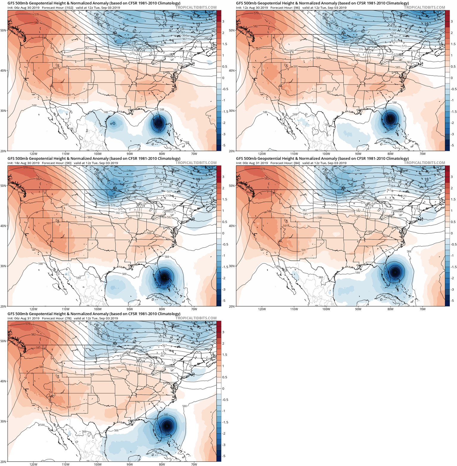
I know everyone is feeling better about things this morning in Florida but take a look at this trend over the last 5 GFS runs, about 3 days from 6am which is still quite a while.

Taking your eye off the storm itself for a second, to me, the trough that is coming down over CONUS looks like it is backing away a little bit, and the High/East of Dorian to the north seems to be building back in a bit over the last couple runs. If these features keep changing like this on run to run, i wouldn't sound the all clear for anyone on the Southern East Coast of the US.

Image
7 likes   

Mouton
S2K Supporter
S2K Supporter
Posts: 221
Age: 79
Joined: Sat Jul 30, 2011 8:13 am
Location: Amelia Island Florida

Re: ATL: DORIAN - Models

#4545 Postby Mouton » Sat Aug 31, 2019 7:57 am

NDG wrote:
KWT wrote:
NDG wrote:The forecasted position for 12z by the latest 06z HWRF is already too far north, something to keep in mind.


Yeah alot of the models are already too far north with its motion. The GFS has somewhat corrected itself but lunches it WNW from about 18z. I wouldn't be shocked if it keeps trundling along like this till it hits the weakness and it doesn't bend WNW like some of the models want.


We need the atmosphere sampled to the north of Dorian, ridging looks a little stronger than what the models showed last night.


We are at 81w 30n Aprox. Been watching barometer closely and the water vapor high levels. Been steady around 1016 since 2 am after rising. My interpretation is a sliver on the ridge got in north of here on a ne to sw diagonal. My concern is the weakness is overdone and any troughs will not be coming soon enough to send this damn thing OTS or even away from fl. Some of the better ensomble members show moves consistent with my analysis. I look at the ukmet as the right most potential track especially with the 12-14mph movement building momentum west. That said the NHC is the pros they get paid. I do not. They also have far more info than I have.
6 likes   

User avatar
Blown Away
S2K Supporter
S2K Supporter
Posts: 10151
Joined: Wed May 26, 2004 6:17 am

Re: ATL: DORIAN - Models

#4546 Postby Blown Away » Sat Aug 31, 2019 8:00 am

Mouton wrote:
NDG wrote:
KWT wrote:
Yeah alot of the models are already too far north with its motion. The GFS has somewhat corrected itself but lunches it WNW from about 18z. I wouldn't be shocked if it keeps trundling along like this till it hits the weakness and it doesn't bend WNW like some of the models want.


We need the atmosphere sampled to the north of Dorian, ridging looks a little stronger than what the models showed last night.


We are at 81w 30n Aprox. Been watching barometer closely and the water vapor high levels. Been steady around 1016 since 2 am after rising. My interpretation is a sliver on the ridge got in north of here on a ne to sw diagonal. My concern is the weakness is overdone and any troughs will not be coming soon enough to send this damn thing OTS or even away from fl. Some of the better ensomble members show moves consistent with my analysis. I look at the ukmet as the right most potential track especially with the 12-14mph movement building momentum west. That said the NHC is the pros they get paid. I do not. They also have far more info than I have.


That’s cool, there is a team of folks across this great country collecting and reporting simple observations and all play a role in the modeling
1 likes   
Hurricane Eye Experience: David 79, Irene 99, Frances 04, Jeanne 04, Wilma 05... EYE COMING MY WAY IN 2024…
Hurricane Brush Experience: Andrew 92, Erin 95, Floyd 99, Matthew 16, Irma 17, Ian 22, Nicole 22…

User avatar
NDG
S2K Supporter
S2K Supporter
Posts: 15446
Joined: Sun Jul 09, 2006 10:14 pm
Location: Orlando, FL

Re: ATL: DORIAN - Models

#4547 Postby NDG » Sat Aug 31, 2019 8:04 am

Getting too close for comfort with its south & westward trend over the northern Bahamas, after 60-72 hrs anything can still be possible. FL don't let your guard down!

Image
Image
3 likes   

User avatar
GeneratorPower
S2K Supporter
S2K Supporter
Posts: 1648
Age: 45
Joined: Sun Dec 18, 2005 11:48 pm
Location: Huntsville, AL

Re: ATL: DORIAN - Models

#4548 Postby GeneratorPower » Sat Aug 31, 2019 8:10 am

NDG wrote:Getting too close for comfort with its south & westward trend over the northern Bahamas, after 60-72 hrs anything can still be possible. FL don't let your guard down!

[url]https://i.imgur.com/ujFdqOn.gif[url]


Nailbiter for sure.
1 likes   

User avatar
syfr
S2K Supporter
S2K Supporter
Posts: 170
Age: 106
Joined: Fri Oct 26, 2012 7:33 pm
Location: East Central NC

Re: ATL: DORIAN - Models

#4549 Postby syfr » Sat Aug 31, 2019 8:11 am

It's really hard to tell which way a stationary object (ANY stationary object) will move.....
1 likes   
I'm not a meteorologist, I'm an electronics engineer. While I can probably fix your toaster oven, you're not going to learn about storms from me!

New Mexico had no hurricanes. Then I moved to NC right before Fran.....

jlauderdal
S2K Supporter
S2K Supporter
Posts: 7184
Joined: Wed May 19, 2004 5:46 am
Location: NE Fort Lauderdale
Contact:

Re: ATL: DORIAN - Models

#4550 Postby jlauderdal » Sat Aug 31, 2019 8:11 am

chris_fit wrote:
HurricaneFrances04 wrote:Doesn't look good for the Northwest Bahamas. I was hoping the north of the Bahamas solution shown by some of the models would pan out last night, but the Euro shows a W/WNW track, which appears to be occurring at the moment.


If a Cat4 parks directly over the Grand Bahama Island, I believe the only chance of avoid total destruction would be actually being in the eye for that long.... If it parks itself with the Eyewall over the Islands, FORGETABOUTIT.
doubt it stalls for that long but the Bahamas like Bermuda isnt built with old run down structures that have seen big winds...most of it is concrete reinforced steel like my house, extremely well built....the Bahamas have seen many major hurricanes, they recover quick and move on, they are pros at dealing with intense hurricanes

back to the models
0 likes   

User avatar
SFLcane
S2K Supporter
S2K Supporter
Posts: 10163
Age: 47
Joined: Sat Jun 05, 2010 1:44 pm
Location: Lake Worth Florida

Re: ATL: DORIAN - Models

#4551 Postby SFLcane » Sat Aug 31, 2019 8:12 am

NDG wrote:Getting too close for comfort with its south & westward trend over the northern Bahamas, after 60-72 hrs anything can still be possible. FL don't let your guard down!

https://i.imgur.com/ujFdqOn.gif
https://i.imgur.com/GCrPxbl.gif


Woah!! Indeed this just to close jeez
0 likes   

User avatar
KWT
Category 5
Category 5
Posts: 31415
Joined: Tue Aug 17, 2004 11:02 am
Location: UK!!!

Re: ATL: DORIAN - Models

#4552 Postby KWT » Sat Aug 31, 2019 8:18 am

NDG wrote:Getting too close for comfort with its south & westward trend over the northern Bahamas, after 60-72 hrs anything can still be possible. FL don't let your guard down!

https://i.imgur.com/ujFdqOn.gif
https://i.imgur.com/GCrPxbl.gif


Yes this matches FAR better against reality then what the GFS/HWRF are showing on their respective 06z for track, which is a constant near WNW motion from here on.

Remember the model bias folks, you eon't go far wrong if you do...

Still too close to call.
0 likes   
Personal Forecast Disclaimer:
The posts in this forum are NOT official forecast and should not be used as such. They are just the opinion of the poster and may or may not be backed by sound meteorological data. They are NOT endorsed by any professional institution or storm2k.org. For official information, please refer to the NHC and NWS products

SunnyThoughts
Category 5
Category 5
Posts: 2263
Joined: Wed Jul 09, 2003 12:42 pm
Location: Pensacola, Florida

Re: ATL: DORIAN - Models

#4553 Postby SunnyThoughts » Sat Aug 31, 2019 8:19 am

Awfully close for sure. If I lived anywhere along the east coast of Fla...I'd take a little trip over this holiday weekend. Drive over to the West coast, or come on up here to the NW panhandle...we'd love to have you guys. Just don't wait till the storm is 50 or 60 miles off the coast and see it isn't going to turn quickly enough. Will be too late to leave then.
2 likes   

User avatar
miami33
S2K Supporter
S2K Supporter
Posts: 8
Joined: Thu Jun 21, 2012 2:44 pm
Location: Coral Gables, FL

Re: ATL: DORIAN - Models

#4554 Postby miami33 » Sat Aug 31, 2019 8:21 am

b0tzy29 wrote:I know everyone is feeling better about things this morning in Florida but take a look at this trend over the last 5 GFS runs, about 3 days from 6am which is still quite a while.

Taking your eye off the storm itself for a second, to me, the trough that is coming down over CONUS looks like it is backing away a little bit, and the High/East of Dorian to the north seems to be building back in a bit over the last couple runs. If these features keep changing like this on run to run, i wouldn't sound the all clear for anyone on the Southern East Coast of the US.

https://media.giphy.com/media/gdZqYNdHnTO641ymqJ/source.gif


When I took my eye off of Dorian, I noticed a couple of yellow X's. More storms to watch. I'll keep refining my preparations for an eventual hurricane. My goal is to keep getting rid of stuff I don't need, and have all my files and photos on a thumb drive.
https://i.imgur.com/lx2e5nz.png
Last edited by miami33 on Sat Aug 31, 2019 8:25 am, edited 2 times in total.
1 likes   

b0tzy29
Tropical Depression
Tropical Depression
Posts: 65
Joined: Sun Sep 02, 2018 9:03 am

Re: ATL: DORIAN - Models

#4555 Postby b0tzy29 » Sat Aug 31, 2019 8:22 am

The weather channel just showed the "official NHC forecast" and not for nothing, but the 00Z Euro at 72 hours, shows the storm significantly further south than the official NHC track, in my opinion.
3 likes   

User avatar
miami33
S2K Supporter
S2K Supporter
Posts: 8
Joined: Thu Jun 21, 2012 2:44 pm
Location: Coral Gables, FL

Re: ATL: DORIAN - Models

#4556 Postby miami33 » Sat Aug 31, 2019 8:27 am

miami33 wrote:
b0tzy29 wrote:I know everyone is feeling better about things this morning in Florida but take a look at this trend over the last 5 GFS runs, about 3 days from 6am which is still quite a while.

Taking your eye off the storm itself for a second, to me, the trough that is coming down over CONUS looks like it is backing away a little bit, and the High/East of Dorian to the north seems to be building back in a bit over the last couple runs. If these features keep changing like this on run to run, i wouldn't sound the all clear for anyone on the Southern East Coast of the US.

https://media.giphy.com/media/gdZqYNdHnTO641ymqJ/source.gif


When I took my eye off of Dorian, I noticed a couple of yellow X's. More storms to watch. I'll keep refining my preparations for an eventual hurricane. My goal is to keep getting rid of stuff I don't need, and have all my files and photos on a thumb drive.
https://i.imgur.com/lx2e5nz.png
Last edited by miami33 on Sat Aug 31, 2019 8:28 am, edited 1 time in total.
0 likes   

underthwx
Category 5
Category 5
Posts: 2362
Joined: Sat Jul 30, 2011 2:14 pm
Location: Brazoria County Texas

Re: ATL: DORIAN - Models

#4557 Postby underthwx » Sat Aug 31, 2019 8:29 am

Blown Away wrote:
Mouton wrote:
NDG wrote:

We need the atmosphere sampled to the north of Dorian, ridging looks a little stronger than what the models showed last night.


We are at 81w 30n Aprox. Been watching barometer closely and the water vapor high levels. Been steady around 1016 since 2 am after rising. My interpretation is a sliver on the ridge got in north of here on a ne to sw diagonal. My concern is the weakness is overdone and any troughs will not be coming soon enough to send this damn thing OTS or even away from fl. Some of the better ensomble members show moves consistent with my analysis. I look at the ukmet as the right most potential track especially with the 12-14mph movement building momentum west. That said the NHC is the pros they get paid. I do not. They also have far more info than I have.


That’s cool, there is a team of folks across this great country collecting and reporting simple observations and all play a role in the modeling

That's true, I read yesterday, that the weather service in Brownsville TX, is sending up weather balloons, to aid in supplying as much information to help forecast this cyclone...its a piece of the weather puzzle, that forecasters need to provide critical info for yall...i find that amazing
1 likes   

Sailingtime
Tropical Low
Tropical Low
Posts: 37
Joined: Thu Aug 29, 2019 7:02 pm

Re: ATL: DORIAN - Models

#4558 Postby Sailingtime » Sat Aug 31, 2019 8:30 am

b0tzy29 wrote:The weather channel just showed the "official NHC forecast" and not for nothing, but the 00Z Euro at 72 hours, shows the storm significantly further south than the official NHC track, in my opinion.


I remember one of the older retired now weather man on an Orlando station 15-20 yrs ago said that when hurricanes get to be a CAT 4 with extremely low pressures, that they can and sometimes do in a sense create their own environment and don't always turn as the weather maps say they should. I'll always remember him saying that and to this day although I enjoy the models and tracking trends etc, I'm still going to keep my guard up until this storm is above my latitude and moving away. My thoughts are to believe the off shore models about 30 miles East of the Cape.
3 likes   

User avatar
Portastorm
Storm2k Moderator
Storm2k Moderator
Posts: 9914
Age: 63
Joined: Fri Jul 11, 2003 9:16 am
Location: Round Rock, TX
Contact:

Re: ATL: DORIAN - Models

#4559 Postby Portastorm » Sat Aug 31, 2019 8:33 am

LAST WARNING!

Enough with the "Point X is in the clear" posts! We have warned y'all repeatedly. No more warnings ... posts will be deleted and suspensions delivered. If you have questions about whether your post crosses the line or not, PM the mods/admins. Chances are if you're wondering if you should hit the "submit" button on your post, it probably means you shouldn't.
23 likes   
Any forecasts under my name are to be taken with a grain of salt. Get your best forecasts from the National Weather Service and National Hurricane Center.

USTropics
Professional-Met
Professional-Met
Posts: 2659
Joined: Sun Aug 12, 2007 3:45 am
Location: Florida State University

Re: ATL: DORIAN - Models

#4560 Postby USTropics » Sat Aug 31, 2019 8:33 am

Don't let your guard down yet, the 06z stall on the ECWMF is a bit concerning still, it's highlighting how subtle steering currents are, the amount of ridging and strength/orientation of the trough are still to be determined. I'd feel more confident in an offshore track if the ensemble mean of the UKMET jumps offshore at 12z. Dorian has proven to be a difficult storm to forecast, even 3 days out, was forecasted to hit Hispaniola, none of the ensemble guidance from the GFS/UKMET/ECMWF even showed a possibility of going east of Puerto Rico.

Image

At 96 hours, the best performing model currently (UKMET) still has a 125 mile absolute position error. The GFS, ECMWF, and even NHC track have a ~200+ positional error at 96 hours. Until Florida is out of the cone, things can change, stay vigilante.

Image
8 likes   


Return to “2019”

Who is online

Users browsing this forum: No registered users and 0 guests