ATL: DORIAN - Models
Moderator: S2k Moderators
-
HurricaneFrances04
- Category 2

- Posts: 597
- Joined: Mon Jun 25, 2012 8:09 am
- Location: Fort Lauderdale, Florida
Re: ATL: DORIAN - Models
Aric Dunn wrote:Just goes to show how delicate the set up.. just a very small amount of missing data caused pretty drastic changes. and the rest of the data might be even more west..
Is there any chance Dorian gets into GOM?
0 likes
Re: ATL: DORIAN - Models
HurricaneFrances04 wrote:18Z GFS Ensembles:
https://www.weathernerds.org/tc_guidance/images/AL05_2019083118_GEFS_0-120h_large.png?20190831233056
Yikes, not good. Very, very few of those paths are reflective of Dorians actual current motion
0 likes
- chris_fit
- Category 5

- Posts: 3261
- Age: 43
- Joined: Wed Sep 10, 2003 11:58 pm
- Location: Tampa Bay Area, FL
Re: ATL: DORIAN - Models
18Z Euro takes Dorian straight up NW in the first 3 hours....before returning to W - interesting - off already?
0 likes
Re: ATL: DORIAN - Models
Blinhart wrote:So this system will most likely be moving further West, the questions now is how far West, will it have a Southern movement at all, will there be a stall, will the troughs be as strong as the models show, will the edge of the HP actually erode away, will the Death Ridge over Texas and Louisiana move a little more West and cause a different opening??????? All these things are questions that most likely won't happen until they actually do happen. That is why this system has so many questions flip flopping just like the models. It would be a lot easier if there was easy and clear evidence of what is going to be happening in the next week, but we are still trying to figure out everything that happens on this big ol' marble we live on.
Tell me about it. The suspense is killing me. Everyday seems so long.
1 likes
-
tolakram
- Admin

- Posts: 20179
- Age: 62
- Joined: Sun Aug 27, 2006 8:23 pm
- Location: Florence, KY (name is Mark)
Re: ATL: DORIAN - Models
Sambucol wrote:Aric Dunn wrote:Just goes to show how delicate the set up.. just a very small amount of missing data caused pretty drastic changes. and the rest of the data might be even more west..
Is there any chance Dorian gets into GOM?
Everything is a percentage. The chances of it making it into the GOM are lower than hitting Florida are lower than it staying just offshore. The ridge is forecast to break down, sending Dorian north, WHEN is the question.
3 likes
M a r k
- - - - -
Join us in chat: Storm2K Chatroom Invite. Android and IOS apps also available.
The posts in this forum are NOT official forecasts and should not be used as such. Posts are NOT endorsed by any professional institution or STORM2K.org. For official information and forecasts, please refer to NHC and NWS products.
Re: ATL: DORIAN - Models
chris_fit wrote:18Z Euro takes Dorian straight up NW in the first 3 hours....before returning to W - interesting - off already?
Keep us updated
A lot of the gfs ens also shoot this nw quickly as well
1 likes
- ScottNAtlanta
- Category 5

- Posts: 2535
- Joined: Sat May 25, 2013 3:11 pm
- Location: Atlanta, GA
Re: ATL: DORIAN - Models
Ken711 wrote:Blinhart wrote:So this system will most likely be moving further West, the questions now is how far West, will it have a Southern movement at all, will there be a stall, will the troughs be as strong as the models show, will the edge of the HP actually erode away, will the Death Ridge over Texas and Louisiana move a little more West and cause a different opening??????? All these things are questions that most likely won't happen until they actually do happen. That is why this system has so many questions flip flopping just like the models. It would be a lot easier if there was easy and clear evidence of what is going to be happening in the next week, but we are still trying to figure out everything that happens on this big ol' marble we live on.
Lots and lots of moving parts.
The fact that the ULL that was supposed to dive SW but hasn't tells me that the high in the GOM that was supposed to move south and provide steering counter to the high currently pushing Dorian west causing a stall is not where it was forecast to be. It is possible the stall will not happen, or happen much later than forecast. I have been watching this most of the day.
Last edited by ScottNAtlanta on Sat Aug 31, 2019 6:55 pm, edited 1 time in total.
5 likes
The posts in this forum are NOT official forecast and should not be used as such. They are just the opinion of the poster and may or may not be backed by sound meteorological data. They are NOT endorsed by any professional institution or storm2k.org. For official information, please refer to the NHC and NWS products.
Re: ATL: DORIAN - Models
Sambucol wrote:Aric Dunn wrote:Just goes to show how delicate the set up.. just a very small amount of missing data caused pretty drastic changes. and the rest of the data might be even more west..
Is there any chance Dorian gets into GOM?
As of right now there is nearly 0% chance of it getting into the GoM. And if you know me, that is hard for me to say, but the only way to know for sure is to wait and see what will happen, there are way to many variables that are changing constantly. If I would put overall odds of it making into the GoM about less than 20%, but right now it is at about 0.05%
4 likes
Personal Forecast Disclaimer:
The posts in this forum are NOT official forecast and should not be used as such. They are just the opinion of the poster and may or may not be backed by sound meteorological data. They are NOT endorsed by any professional institution or storm2k.org. For official information, please refer to the NHC and NWS products.
The posts in this forum are NOT official forecast and should not be used as such. They are just the opinion of the poster and may or may not be backed by sound meteorological data. They are NOT endorsed by any professional institution or storm2k.org. For official information, please refer to the NHC and NWS products.
- chris_fit
- Category 5

- Posts: 3261
- Age: 43
- Joined: Wed Sep 10, 2003 11:58 pm
- Location: Tampa Bay Area, FL
Re: ATL: DORIAN - Models
so far 18Z Euro is similar to 12Z - right over middle Abacore Island in 24 hours.
2 likes
Re: ATL: DORIAN - Models
chris_fit wrote:18Z Euro takes Dorian straight up NW in the first 3 hours....before returning to W - interesting - off already?
Sometimes the models try to snap the low into a place that it thinks is most reasonable. Doesn't necessarily mean it's wrong, but you do have to slightly adjust track manually to compensate.
2 likes
Personal Forecast Disclaimer:
The posts in this forum are NOT official forecast and should not be used as such. They are just the opinion of the poster and may or may not be backed by sound meteorological data. They are NOT endorsed by any professional institution or storm2k.org. For official information, please refer to the NHC and NWS products
The posts in this forum are NOT official forecast and should not be used as such. They are just the opinion of the poster and may or may not be backed by sound meteorological data. They are NOT endorsed by any professional institution or storm2k.org. For official information, please refer to the NHC and NWS products
- Blown Away
- S2K Supporter

- Posts: 10253
- Joined: Wed May 26, 2004 6:17 am
Re: ATL: DORIAN - Models

Dorian moving along the S side of nearly all the 18z GFS ensembles...
5 likes
Hurricane Eye Experience: David 79, Irene 99, Frances 04, Jeanne 04, Wilma 05… Hurricane Brush Experience: Andrew 92, Erin 95, Floyd 99, Matthew 16, Irma 17, Ian 22, Nicole 22…
- chris_fit
- Category 5

- Posts: 3261
- Age: 43
- Joined: Wed Sep 10, 2003 11:58 pm
- Location: Tampa Bay Area, FL
Re: ATL: DORIAN - Models
18z EURO at 39 hours it's as W it ever got on the 12Z - let's see what happens next (W shift or N)
0 likes
- chris_fit
- Category 5

- Posts: 3261
- Age: 43
- Joined: Wed Sep 10, 2003 11:58 pm
- Location: Tampa Bay Area, FL
Re: ATL: DORIAN - Models
18z EURO still stalled over Grand Bahama island (E end) at 51 hours
0 likes
-
tolakram
- Admin

- Posts: 20179
- Age: 62
- Joined: Sun Aug 27, 2006 8:23 pm
- Location: Florence, KY (name is Mark)
Re: ATL: DORIAN - Models
Another horrible stall right over the island. Sheesh 
0 likes
M a r k
- - - - -
Join us in chat: Storm2K Chatroom Invite. Android and IOS apps also available.
The posts in this forum are NOT official forecasts and should not be used as such. Posts are NOT endorsed by any professional institution or STORM2K.org. For official information and forecasts, please refer to NHC and NWS products.
- - - - -
Join us in chat: Storm2K Chatroom Invite. Android and IOS apps also available.
The posts in this forum are NOT official forecasts and should not be used as such. Posts are NOT endorsed by any professional institution or STORM2K.org. For official information and forecasts, please refer to NHC and NWS products.
Re: ATL: DORIAN - Models
Blown Away wrote:https://i.imgur.com/iF3P4ol.jpg
Dorian moving along the S side of nearly all the 18z GFS ensembles...

0 likes
Re: ATL: DORIAN - Models
HurricaneFrances04 wrote:18Z GFS Ensembles:
https://www.weathernerds.org/tc_guidance/images/AL05_2019083118_GEFS_0-120h_large.png?20190831233056
Wow, that's 7 members now showing showing partial* landfall either along the immediate coast or well inland.
Last edited by NDG on Sat Aug 31, 2019 7:05 pm, edited 1 time in total.
0 likes
- gatorcane
- S2K Supporter

- Posts: 23708
- Age: 48
- Joined: Sun Mar 13, 2005 3:54 pm
- Location: Boca Raton, FL
Re: ATL: DORIAN - Models
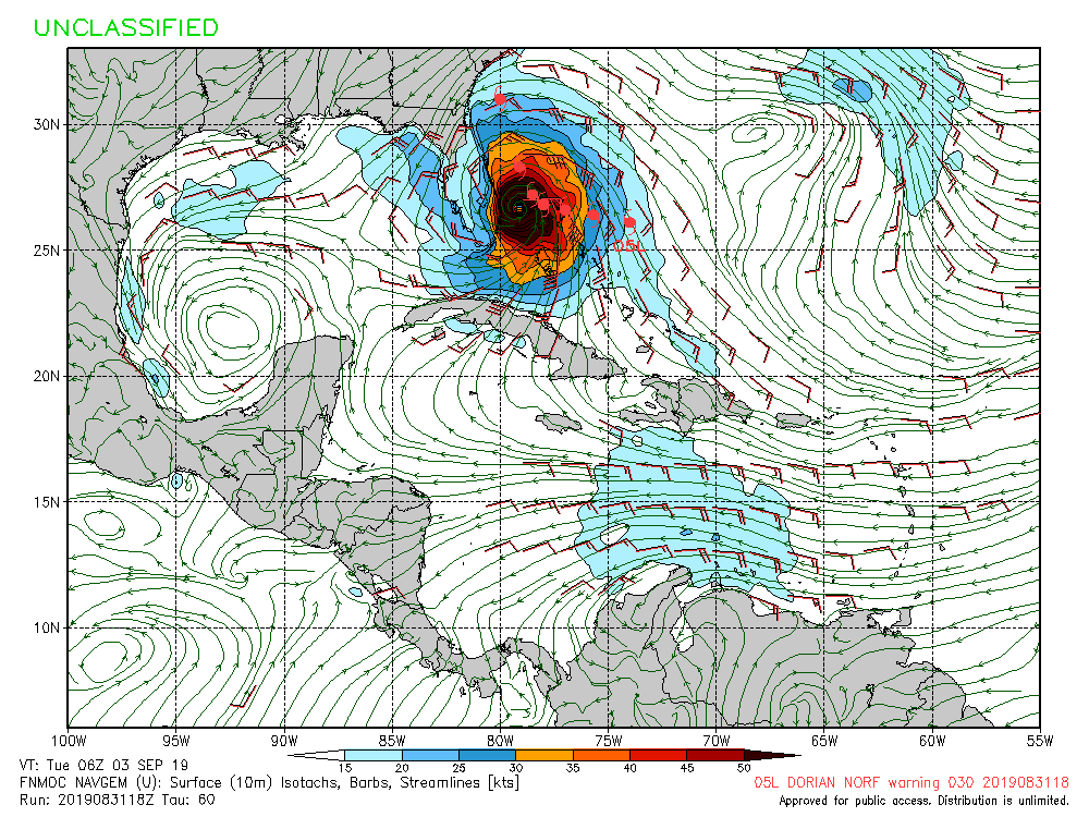
Another look at the 18Z NAVGEM:


Last edited by gatorcane on Sat Aug 31, 2019 7:05 pm, edited 1 time in total.
1 likes
Who is online
Users browsing this forum: No registered users and 89 guests
